Note: Descriptions are shown in the official language in which they were submitted.
2158500
NAVIGATION SYSTEM FOR AN AUTOMOLlv~ VEHICLE
BACKGROUND OF THE lN V ~ r, 1 lON
1. Field of the Invention
The present invention relates to a navigation system
for an automotive vehicle and, more particularly, to an
improvement for determining a navigation route from the
current position of an automotive vehicle to a given
destination.
2. Backqround of the Invention
Electronic navigation and information systems have
been developed for implementation in automotive vehicles.
These systems alleviate the driver or the passengers of an
automotive vehicle from the task of finding the best route
to a destination. Such systems are particularly useful in
regions unfamiliar to the driver in that it avoids the
tedious tasks of map interpretation.
The prior-art systems have further been adapted to
display the current position and traveling direction of
the automotive vehicle in correlation with a map image
overlapped on a display screen of a CRT (cathode ray tube)
display unit located adjacent the driver's seat of the
vehicle so as to further assist the driver in navigation
tasks.
In order for such a system to provide the
aforementioned navigation services, the system must be
oriented to the actual position of the automotive vehicle
relative to a road map. The actual position of an
automotive vehicle may be determined in correlation with
the global positioning system (GPS), the LORAN navigation
system, an inertia navigation system (e.g., the dead-
reckoning system) or a radar-like service such as ranging.
For example, the global positioning system (GPS)
determines the position of an automotive vehicle in a
2158500
-- 2
global geometrical region through the method of
triangularization. Typically, a global positioning system
includes a receiver for receiving radio waves transmitted
from three or more GPS satellites. The global positioning
system determines the position of a reception point where
the receivers have received the radio waves, based on
quasi-distance data between the GPS satellites and the
reception point, including a time offset of the receiver,
and positional data of the GPS satellites.
Once the actual position of the automotive vehicle is
determined and the desired destination has been inputted
by the user, the system is then enabled to provide the
vehicle operator with information regarding the best route
to be followed from the current vehicle location to a
desired destination. In the prior art, the best route is
determined through the process of discovering the minimum
distance between the desired destination and the actual
position of the automotive vehicle. However, such a
process is prone to setbacks. One such setback is that
the prior art system does not take into account route
speed rates. For example, two competing routes
(A and B) connect the automotive vehicle to a desired
destination. Route A has a travel length of 30 miles and
a corresponding speed rate of 25 mph, and route B has a
travel length of 35 miles and a corresponding speed rate
of 45 mph. The prior art system would select route A in
view of its shorter travel length (30 miles) eventhough
route B (35 miles) would provide the quickest route (in
time) to the desired destination. Therefore, the prior
art is in that it determines the best route to only be a
function of its travel length and not rate of speed.
SUMMARY OF THE lNv~NLlON
The present invention relates to a navigation system
for an automotive vehicle, and in particular to a
2158500
navigation system adapted to determine the best route to a
selected destination on the basis of the time necessary to
travel such a route. The system includes positioning
means for determining the actual position of the
automotive vehicle relative to a displayed road map.
Preferably, the positioning means includes the global
positioning system (GPS) which determines the position of
the automotive vehicle by measuring the propagation delay
times of signal waves propagated from GPS satellites
circling around the earth in predetermined orbits.
The system further includes map means for storing a
plurality of road maps, wherein the map means may include
a CD-ROM device mounted in the automotive vehicle or a
central database which transmits road map information to
the automotive vehicle. In conjunction with the map
means, the system includes selecting means for selecting a
road map from those stored in the map means on the basis
of the current position of the automotive vehicle.
Display means are provided for displaying the current
position of the automotive vehicle on a selected map.
Input means are further provided for enabling a user to
select a desired destination stored in the map means.
The best route to a selected destination is determined
by means which is adapted to select a navigation route of
a shortest duration from the current location of the
automotive vehicle to the selected destination. The
method for determining the aforementioned best route
includes the steps of identifying the available navigation
routes from the current position of the automotive vehicle
to the desired destination. After which, the travel
length and rate of speed of each identified navigation
route is determined. The time necessary to travel each
identified navigation route is then calculated in
dependence upon its determined travel length and rate of
~ 585~0
-- 4
speed. The best route is therefore the identified
navigation route which requires the shortest travel time.
In accordance with one aspect of the invention there
is provided a vehicle navigation system for identifying a
desired map route between a first position of a vehicle and
a second position, which comprises: (a) map means for
storing a plurality of road maps and speed limit values for
roads therein; (b) input means for enabling a user to
select said first and second positions; (c) selecting means
for selecting a road map from those stored in said map
means on the basis of said selected first and second
positions of said vehicle; (d) traffic receiving means for
receiving traffic information including speed rates
transmitted in a data representation format of variable
length differences from said stored speed limit values for
respective roads contained on said selected road map over a
wireless channel from a centrally located database to said
vehicle; and (e) means for determining a route of shortest
duration between said first position and said second
position from said selected road map on the basis of said
speed rates received by said traffic receiving means and
the length of travel between said first and second
positions of said vehicle.
In accordance with another aspect of the invention
there is provided a method of determining a best navigation
route from an actual position of an automotive vehicle to a
selected desired destination which comprises the steps of:
(a) determining the actual position of said automotive
vehicle; (b) storing a plurality of road maps and speed
limit values for roads on said maps; (c) selecting a
desired destination from one of said stored road maps; (d)
identifying the navigation routes from the actual position
of said automotive vehicle to said selected desired
destination; (e) receiving traffic information on the basis
of the actual position of, said automotive vehicle
including speed rates of said identified navigation routes
transmitted in a data representation format of variable
length differences from said stored speed limit values for
,~,:.~
~ ~ ~ 8 5 n a
- 4a -
respective roads over a wireless channel from a centrally
located database to said automotive vehicle; (f)
determining travel time necessary to travel each of said
identified navigation routes based on the traffic
information received; and (g) selecting one of said
identified navigation routes having the shortest travel
time.
BRIEF DESCRIPTION OF THE DRAWINGS
The foregoing features of the present invention will
become more readily apparent and may be understood by
referring to the following detailed description of
illustrative embodiments in accordance with the subject
invention with reference to the drawings wherein:
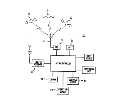
FIG. 1 illustrates a block diagram of a preferred
embodiment of a navigation system according to the present
invention;
FIG. 2 illustrates a central database in communication
with the navigation system of FIG. l; and
FIG. 3 illustrates a flow chart depicting the method
of selecting a best route in accordance with the present
invention.
DETAILED DESCRIPTION OF THE PREFERRED EMBODIMENTS
Referring now to the drawings, in which like reference
numerals identify similar or identical elements. FIG. 1
illustrates a block diagram of a navigation system adapted
to implement the present invention, designated generally by
reference numeral 10. Such a system 10 preferably includes
a global positioning system (GPS) 26 for approximating the
actual position of an automotive vehicle 70 (FIG. 2), as is
conventional. The GPS 26 is illustrative only and is a
preferred embodiment adapted for the implementation of the
present invention. The system 10 is not to be limited to
the aforementioned GPS 26 for approximating the current
position of the automotive vehicle, but may rather
incorporate other known positioning means such as: LORAN;
Dead-Reckoning; or radar services.
The configuration of the navigation system 10 shown
in FIG. 1 includes a microcontroller 22, and a cathode ray
215850~
-- 5
tube (CRT) 20 coupled to the microcontroller 22 adapted to
display images for navigation of an automotive vehicle 50
(FIG. 2). An input source 25, preferably in the
configuration of a keyboard (not shown), is coupled to
microcontroller 22 to enable driver input into the system
10 (e.g., to enable a driver to designate a destination
while viewing the CRT 20 or input a desired traveling
route). The input source 25 may alternatively be a touch
panel (not shown) implemented on the screen of the CRT 20
wherein the touch panel utilizes light-emitting diodes and
light-receiving elements. The system 10 further
preferably includes a conventional CD-ROM (compact disc
read only memory) 24 coupled to the microcontroller 22.
As is conventional, the CD-ROM 24 is adapted to store
various road map information classified in accordance with
selected geographical regions.
The aforementioned global positioning system receiver
(GPS) 26 is coupled to the microcontroller 22 and is
adapted to receive positioning signals, via antenna 27,
from GPS satellites 29, 31 and 33 so as to enable the
approximation of the actual position of the automotive
vehicle. Preferably, the microcontroller 22 is coupled to
both a direction sensor 28 for detecting the direction of
travel of the automotive vehicle, and a distance sensor 30
for measuring the traveling distance of the automotive
vehicle to assist the GPS 26 in the approximation of the
actual position of the automotive vehicle.
In accordance with the present invention and with
continued reference to FIG. 1, the system 10 includes the
provision of a traffic information receiver 32 coupled to
the microcontroller 22. The traffic information receiver
32 is adapted to input traffic information into the
microcontroller 22 to be processed therein and displayed
on the CRT 20. For example, such traffic information may
~ S85~
- 6 -
include traffic congestion, traffic speed, road conditions,
road closures, detours, etc.
Referring now to FIG. 2, the traffic information
receiver 32 receives such traffic information preferably
from a central database 50, via a wireless radio link 42
and respective antennas 54 (FIG. 1) and 56. The
transmitted traffic information is in preferably a minimum
data representation format so as to minimize transmission
time. For example, a locally stored map typically has
speed limits, while the transmitted data consists of
variable length differences from the typical value where no
information is transmitted in furtherance of
inconsiderable differences from the aforementioned typical
value. To further minimize transmission time, high degree
quantization of speed limit differences is employed. For
example, for 12 mph reduction on the average on a certain
road, the transmitted information can be reduced to 10 mph.
Still further to minimize transmission time, typical
patterns with season or during a day are captured and
placed into databases so that the updated transfer of
information is minimized. Preferably, the traffic
information, such as traffic speed corresponding to a route
of travel, is periodically updated and inputted into the
central database 50 either via human observation or from
actual electronic road measurement devices.
In another preferred embodiment of the present
invention, traffic information is periodically updated to
the central database 50 whereby mobile users periodically
transmit their respective position and speed to the central
database 50. The central database 50 is configured to then
average the aforementioned received information provided by
the mobile users so as to determine the average speed rate
on various traffic rates. Preferably, each mobile user is
enabled to initiate the minimum path information, and by
notifying the central
2158500
- 7 -
database 50 of its position and its destination, the
mobile user can obtain the best route information from the
central database 50. Still further, the transmitted
wireless message from each mobile user may include any
known type of information such as differential correction
information from the GPS receiver 26.
Further, the central database 50 may be adapted to
store and transmit the aforementioned various road map
information to the microcontroller 22 implemented in the
automotive vehicle 70 so as to obviate the need for the
CD-ROM 24. Therefore, the various road map information to
be displayed on the CRT 20, in another preferred
embodiment of the present invention, is transmitted from
the central database 50 to the microcontroller 22 in the
automotive vehicle 70. Further, it is to be appreciated
that the updated traffic information provided to the
traffic information receiver 32 may be provided to the
user on request via a wireless channel (i.e., a premium
service). Still further, trouble traffic stops may be
preferably immediately broadcasted on a broadcast channel
which is being monitored by the user.
The microcontroller 22 is coupled to a processing unit
34 which is adapted to read a road map related to a
geographical region in which the automotive vehicle is
currently traveling from the CD-ROM 24 on the basis of the
current position of the automotive vehicle as detected by
the GPS 26. Preferably, in the preferred embodiment of
the present invention, each stored road map is converted
into a data structure wherein a street map includes at
least two fields including the speed and length of each
route stored thereon. The microcontroller 22 is adapted
to then display the actual position of the automotive
vehicle overlapped with an appropriate road map on the
display screen of the CRT 20. The processing unit 34 is
further adapted to calculate the best route to a selected
2158500
destination on the basis of the travel length and traffic
speed of individual routes, as discussed in detail below.
As mentioned above, in the prior art, the best route
was calculated on the basis of the shortest navigation
route between the current position of the automotive
vehicle and the desired destination. However, such a best
route calculation was prone to setbacks. One such setback
was that the respective speed limits of competing routes
was not considered in the best route calculation.
The method of determining a best route is illustrated
in the schematic of FIG. 3. It is noted that the best
route may either be determined in the aforementioned
processing unit 34 or the central database 50. For
example, if the system 10 does not utilize a CD-ROM 24,
then the central database 50 maybe configured to both
store various road maps of geographical regions as well as
calculate the best route to a given destination. Further,
in another preferred embodiment, the system 10 may utilize
a CD-ROM 24 or equivalent structure (i.e. a magnetic tape
drive) to store various road maps, wherein the processing
unit 34 retrieves the map information from the CD-ROM 24,
the automotive vehicle's current position from the GPS
receiver 26 and traffic information from the central
database 50 to calculate the best route to a given
destination. One skilled in the art may configure the
aforementioned system 10 in numerous configurations to
calculate a best route as illustrated and described
hereinbelow.
Referring to FIG. 3, the user (e.g., the operator of
the automotive vehicle) first activates the best route
program, block 100, by inputting appropriate information
into the input source 24 (FIG. 1). The user then inputs,
via the input source 25, a particular desired destination,
block 110. The microcontroller 22 then retrieves the
2158500
current position of the automotive vehicle from the GPS
receiver 26, block 120. The system 10 next identifies the
navigation routes available for travel between the current
position of the automotive vehicle and the aforementioned
desired destination, block 130. The system 10 then
determines the length (e.g., miles, kilometers, etc.) of
each aforementioned identified route, block 140. The rate
of speed, via the central database 50, of each
aforementioned identified route is then determined, block
150.
Once the travel length, block 140, and rate of
speed, block 150, of each identified route has been
determined, the system 10 then determines the required
time to travel each identified route, block 160, by
correlating its travel length, block 140, with its rate of
speed, block 150. For example, the system 10 determines
that there are two competing routes (e.g., A and B)
interconnecting the current position of the automotive
vehicle, block 120, to the selected desired destination,
block 110. Route A has a travel length of 80 miles, block
140, and a corresponding rate of speed of 40 miles per
hour (MPH), block 150, while route B has a travel length
of 90 miles, block 140, and a corresponding rate of speed
of 60 MPH, block 150. Therefore, route A requires a
travel time of 2 hours, (travel time = travel length/rate
of speed), while route B requires a travel time of 1~
hours. Thus, the system 10 is adapted to identify route A
to be the best route, block 170, in view of its shorter
travel time (e.g., 1~ hours) in comparison to route A
(e.g., 2 hours). The best route is thus more accurately
determined based upon travel time in dependence upon its
travel length and rate of speed.
While the invention has been particularly shown and
described with reference to preferred embodiments, it will
be understood by those skilled in the art that various
21S8500
- 10 -
modifications in form and detail may be made therein
without departing from the scope and spirit of the
inventlon. It is to be appreciated for instance, that the
system 10 of the present invention may calculate the best
route in either the aforementioned microcontroller 22 or
central database 50. It is further contemplated that the
system 10 of the present invention may be integrated for
use in a driverless vehicle navigation system.
Accordingly, modifications such as those suggested above,
but not limited thereto, are to be considered within the
scope of the invention.