Note: Descriptions are shown in the official language in which they were submitted.
~16~3"~~
Method and eguipment for performing measurements while drilling for oil and
gas
The present invention relates to a method and equipment for performing
measurements while drilling for oil and gas in formations beneath the earth
surface,
particularly VSP-measurements involving the use of a seismic source and
sensors,
together with a memory and calculation device for storing and processing the
received
seismic signals.
When extracting oil and gas from formations underneath the earth surface/sea
bed,
measurements are performed in the wells that are drilled in order to obtain
information
such as the position of the bit, oil/gas composition/quality, pressure,
temperature and
other geophysical and geological conditions.
Commonly, well measurements are performed in four phases; when performing
drilling
operations, (MWD - Measurements While Drilling), when logging after the
drilling
operations have been completed during completion of the well and in the
production
phase.
MWD has primarily been introduced as an aid for direction control when
drilling (by
position measurements), but gradually this method has also replaced the
logging-phase.
Furthermore, MWD appears to be the only way of collecting logging information
in
extended reach wells and in horizontal wells. The application of the MWD
equipment
has resulted in a reduction of the logging costs and it has made it possible
to take
measurements at locations not previously accessible.
Seismic measurements such as VSP (Vertical Seismic Profiling) have commonly
been
performed in the logging phase, but measurements of this type have also been
employed in the completion phase and the production phase of the wells.
216~3~~
2
For a long time, there has been a demand for performing VSP-measurements in
the
drilling phase, referred to as MWD-VSP, as it is assumed that this will reduce
costs,
but equipment for performing such measurements has not been available until
now.
VSP-measurements are in particular employed to determine the vertical travel
time
through the ground in a frequency band that is characteristic for seismic
records
acquired at the surface of the earth. By these means, detailed measurements
performed in the well may be intergrated with seismic measurements performed
at the
surface of the earth. In VSP-measurements, the source will be located close to
the
surface or in the well, with corresponding sensors in the well or close to the
surface.
Today, data from VSP-measurements are collected by means of a source located
close to the sea surface, and with the recording system connected to the
logging
cable. The geometry of the VSP-measurements may further be used for recording
reflected signals that are weak, and that represent structural surface
elements
(stratigraphic borders/fault planes) in the close (max. one km.) vicinity of
the well
(primarily under, but also to the side of and above the well). MWD-VSP is
equivalent
to a VSP logged in the traditional manner, and may at the same time be used as
an
aid for direction/position control when performing the drilling operation.
There is a previously known method based upon "passive" source MWD-VSP where
the drill bit serves as source, and where the recording equipment is placed
upon the
sea bed.
This method is somewhat dated, and today it still represents the sole method
developed for industrial applications. The method was marketed as a successor
to
traditional VSP on its introduction (1988), but it has proved to be encumbered
with so
many substantial limitations that few data have been collected under
operational
conditions that characterise drilling in the North Sea. The companies that
invented the
method point out that the most essential condition for generating signals that
are
sufficiently strong, is to use drill bits of the "roller cone" type. Thus, the
method is not
considered to be of current interest for use in conjunction with other types
of drill bits,
and therefore most of the delineation and production wells in the North Sea
cannot be
served by this method. The signal transmitted and the time of first arrival
are often
~1~437~
3
partly degraded to a relative accuracy of 5 msec and to an absolute accuracy
of
approximately 10 msec. These uncertainties are not acceptable when performing
measurements in delineation and production wells. The examples given by the
contractors relating to the use of the reflected signals, have not been
considered as
usable, and the details in the reflected signals that are critical in a
drilling operation
and in the interpretation of the surface seismic after the drilling operation
has been
completed are at a level substantially below the noise level present in the
records.
The disadvantages that characterise the passive source mentioned above, may be
avoided by making the source strong and controllable. Among other things,
there
have been suggestions to apply sources driven by the circulating drilling mud,
and
tests of the use of a telemetry pulser as a source have been performed.
Further, tests
have been performed employing special sources that are stronger than the
telemetry
pulser. Meanwhile, it is uncertain whether such a source will be harmful to
the well
and whether the energy level in the mud will be sufficient for driving more
powerful
sources while still meeting the demand for the energy needed in the drilling
operation.
The present invention provides a method and a design of equipment for
performing
seismic measurements (MWD-VSP measurements) during drilling operations, where
the above-mentioned disadvantages are completely or at least substantially
eliminated. Thus, a solution is hereby proposed that offers the possibility of
performing measurements in extended wells and horizontal wells, and of
utilising the
VSP-measurements in an active manner as a direction control device during
drilling
operations. These two applications, and the fact that logging after the
drilling
operation has been completed is now redundant, will lead to substantial cost
reductions when drilling for oil or gas.
Furthermore, an extended use of the calculation unit in the drill string will
lead to an
optimal utilisation of the communication possibilities between the drill
string and the
rig.
CA 02164377 2005-O1-14
26625-214
4
According to one aspect of the invention there is
provided a method of performing measurements while drilling
for oil or gas, the method comprising: generating signals by
a seismic source positioned near the surface of the earth;
detecting the signals generated by the seismic source with
sensors located in the vicinity of the seismic source and
with sensors located in a drill string; transmitting the
signals, detected by the sensors in the drill string, to a
memory and calculation device located in the drill string;
processing the detected signals and transmitting the
processed signals in whole or in part to a central data
processing unit located at the earth's surface; transmitting
the signals, detected by the sensors located at the surface,
to the central data processing unit simultaneously with the
transmission of the processed signals; and calculating
travel time of the seismic signals between the seismic
source and the sensors in the drill string using a first
chronometer operably connected to the seismic source and a
second chronometer operably connected to the memory and
calculation device located in the drill string, wherein the
first and second chronometers are synchronized.
According to another aspect the invention provides
apparatus for performing measurements while drilling for oil
or gas, said apparatus comprising: a seismic source; first
sensors positioned near said source; second sensors,
positionable in a drill string, for detecting signals from
said source; a memory and calculation device positionable in
a drill string and operably connected to said second sensors
for processing and transmitting signals from said second
sensors; a central data processing unit for receiving all or
part of the signals processed by said memory and
CA 02164377 2005-O1-14
26625-214
4a
calculation device, and for simultaneously receiving signals
transmitted from said first sensors; a first chronometer
connected to said seismic source; and a second chronometer
connected to said memory and calculation device, wherein
said first and second chronometers are synchronized and
facilitate a precise calculation of the travel time of a
seismic signal from said source to said second sensors.
In the following, the invention is described in
detail with reference to drawings that illustrate an
embodiment thereof, where Fig. 1 shows the principles of the
method and the equipment according to the invention, while
Fig. 2 shows an example of signals as they will be
registered in the implementation of the method.
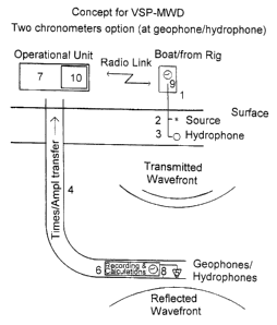
The use of the method and the equipment is based
upon the application of a seismic source 2 located at or in
the vicinity of the surface of the earth, the source being
controllable from a rig or a ship 1. The use further
implies one or more sensors such as a hydrophone 3 or the
like, located close to the source 2 and controllable from
the rig 7. Sensors such as geophones (or hydrophones) 5
together with a memory- and calculation unit 6 are embedded
in the drill string. The programs used in the memory- and
calculation unit are designed to process the signals that
are received by electrical cables from the seismic sensors 5
or other registration units or sondes for the measurement of
temperature, pressure, or the like.
In the memory- and calculation unit 6 in the drill
string, all data registered during the drilling operation
are stored. Only the data that are needed immediately, e.g.
acoustical data to determine the position of the drill head,
will be transmitted through
5
the drill string 4 to a central data processing unit on the rig 7 at the
surface. Signals
received from the sensors 3 near the source 2 will simultaneously be
transmitted from
the rig/ship 1 by radio/telemetry to the central data processing unit 10 on
the drilling
platform. All the other signals that are recorded in the memory- and
calculation unit 6
in the drill string, and that are of no immediate interest, will be
transmitted to the
central unit as the drill string is withdrawn.
Elements of great importance in the equipment according to the present
invention are
the use of chronometers 8 and 9 in connection with the memory- and calculation
unit 6
in the drill string 4 and the central data processing unit on the rig 7. These
chronometers show identical times with a deviation of ~ 1 millisecond or less.
When
using such chronometers in connection with the equipment as described above,
the
following will be achieved:
1. Two-way measurements of the travel time (TWT) and measurements of the
acoustic impedance for the stratum in which the drill string with its sensors
5
is located, and immediate transmission of the signals.
2. The memory unit 6 that contains traditional VSP-data, may be emptied at
each withdrawal of the drill string, and processing the data for localisation
of
reflecting planes may be rapidly performed after the drilling operation has
been terminated.
Seismic measurements during the drilling operation according to the invention
will be
performed as follows:
The circulation of the drilling fluid is interrupted as the sensors 5 in the
drill string are
activated for the registration of sound signals discharged from the seismic
source 2.
In the following 60-120 seconds (according to Fig. 2) the memory- and
calculation unit
6 will acquire all signals from the sensors in the drill string. Fig. 2 shows
signals
registered by a sensor after the discharge of four shots from the seismic
source. The
6
signals contain both the transmitted and the reflected waveforms. The sources
must
be discharged within a fixed interval of time. After this time interval, the
content of the
memory unit are copied to the calculation unit and are processed to determine
the
number of shots, the mean arrival time, and the mean amplitude of the first
arrived
signals. This information may be returned to the surface while the drilling
fluid is put
into circulation again.