Note: Descriptions are shown in the official language in which they were submitted.
217659
ALL-ASPECT BOMB DAMAGE ASSESSMENT SYSTEM
BACKGROUND
The present invention relates generally to bomb damage assessment systems,
and more particularly to an all-aspect piggyback bomb damage assessment system
for
missiles comprising an imaging system that is piggybacked to a weapon to
provide
imagery of a bombed area before and after weapon impact.
The advantage of timely target area damage assessment during wartime is so
great that it is hard to overstress. For example, in the Tomahawk missile
attack against
the intelligence headquarters of the Iraqi government, five missiles strayed
from their
assigned targets, causing serious collateral damage to civilians. Iraqi
spokesmen
immediately appeared on worldwide television accusing the United States of
inhumane
warfare. Because the military did not know where the errant missiles hit for
some time,
the military and political leaders were unable to comment intelligently on the
situation,
and were upset as a result. Clearly, sporadic combat under difficult
conditions places a
premium on rapid and accurate assessment of bomb damage. Under normal combat
conditions, rapid accurate assessment of damage enables commanders to deploy
their
assets to greatest advantage.
Previous methods of obtaining bomb damage assessment utilize reconnaissance
aircraft, unmanned air vehicles (UAVs), and satellites. Unmanned air vehicles
have
been used to carry cameras that either record or relay imagery back to an
operating
base. The unmanned air vehicles are relatively expensive, but may be re-used.
Coor-
dination of the flight of the unmanned air vehicle with the attack of the
target area is
required, and the target must be within the operating range of the unmanned
air vehicle.
CA 02173659 1999-06-25
2
Reconnaissance aircraft have been used that generally operate at high altitude
and require clear weather to assess the target area. In essence,
reconnaissance aircraft
represent a very expensive long range version of an unmanned air vehicle.
Reconnaissance aircraft are limited to low hazard areas and may be obscured
cloudes
and other obscurants if forced to operate from high altitudes. Both aircraft
and
unmanned air vehicles must be coordinated with the attack if they are to
produce
timely outputs.
Satellites incorporating television or infrared cameras have been used as bomb
damage assessment systems. Bombed areas are imaged using the cameras after
bomb
l0 delivery. However, imaging results are dependent upon good weather in
target areas.
There is also a time delay until the satellite passes above the target area.
Furthermore,
satellite systems are relatively expensive to operate. However, satellite
orbits are
predetermined, and m.ay not be timely with regard to a particular event. In
addition,
control of the satellites is subject to administrative procedures before they
can be
~ 5 made available to tactical commanders, adding a time delay to the
assessment process.
Therefore, it is an object of the present invention to provide an all-aspect
bomb damage assessment system. It is a further objective of the present
invention to
provide a bomb damage assessment system that may be piggybacked to a bomb to
provide imagery of a bombed area immediately before and after weapon impact.
SUMMARY OF THE INVENTION
In order to meet the above and other objectives, the present invention
provides
an all-aspect bomb damage assessment system that comprises a glider containing
an
imaging system that i:> carned by an air-to-ground weapon and released prior
to
weapon impact and which provides imagery of a target area before, during and
after
weapon delivery. The glider has folding wings and/or fins, and may be carried
internally or externally by the weapon. As the target area is approached, the
glider is
released or ejected, is decelerated by a deployable ballute, the wings and/or
fins are
unfolded, and the ballute is released, resulting in an aerodynamic glider
configuration
3o that flies much slower than the weapon. The glider arrive at the target
area
approximately 30 to 60 seconds after impact of the weapon. The glider is
equipped
with an imaging system or sensor capable of night vision and daytime vision,
and
CA 02173659 1999-06-25
3
programmable tracking and guidance electronics comprising a guidance and
control
system for controlling tracking and guidance electronics comprising a guidance
and
control system for controlling the flight thereof.
In operation, shortly after separation from the weapon, the imaging system
tracks the weapon to :impact. The explosion releases a burst of heat that
temporarily
results in a "white-out" of the image scene viewed by the imaging system. The
imaging system continues to look at the point of impact and normal vision
returns
after a few seconds. 'the burst leaves a hot spot at the target area that is
tracked by the
imaging system. The hot spot is tracked until a preselected depression angle
is
l0 reached.
At this point, the glider, using its programmable guidance electronics, is
caused to turn until th.e target hot spot is at 90 degrees relative to the
centerline of the
glider. For example, if 80 degrees is the selected angle, the glider is
programmed to
turn so that an angle 80 degrees relative to the hot spot is maintained. This
results in
15 the glider travelling a spiral glide path around the hot spot so that the
target area is
viewed from all aspects. The spiral path also results in a monotonically
decreasing
range to the hot spot. Using a fixed field of view imaging sensor in the
imaging
system, a large amount of background is seen from long range and good linear
resolution is obtained at short range until the glider descends to the ground.
Because
2o the glider descends to low altitudes, it operates under most cloud ceilings
and has a
better opportunity to penetrate fog, smoke, and haze.
In addition to hot spot tracking, the glider of the present invention may also
employ GPS (global positioning system) guidance. The glider may include a GPS
receiver integrated into the guidance and control system. The target location
in GPS
25 coordinates may be entered into the guidance and control system. When the
glider is
released from the weapon, it may be programmed using the programmable
processor
and guidance and flight control system to fly along a specific path or
geometric
surface in GPS coordinates, such as along a converging cone centered in the
coordinates of the target, for example.
3o Imagery .produced by the imaging system is relayed to a combat command
center via satellite, aircraft, or unmanned air vehicle, for example by an on-
board
communications link. The imagery is then assessed to evaluate damage and plan
CA 02173659 1999-06-25
3a
further stiikes if needed. Multiple sensor channels may be provided as part of
the
imaging system to handle multiple weapon attacks. The present invention
provides
high quality damage a;~sessment imagery on a timely basis, typically within
two to
five minutes of weapon impact.
Accordingly, the present invention also provides a damage assessment system
that is releasably secured to a weapon for providing imagery of a target area
before
and after impact of the weapon at the target area, wherein said system
comprises:
a glider including:
a body;
1o a plurality of folded wings and tail fms that are deployable from the
body;
an imaging system disposed at a front end of the glider;
a folded deployable ballute disposed at a rear end of the glider that is
deployable to decelerate the glider;
15 control means for controlling the flight path of the glider and for causing
the
glider to fly a predetermined flight path that permits the imaging system to
view the
target area from all aspects; and
a data link for coupling to the imaging system for transmitting images derived
from the imaging system to a remote location that permits assessment of the
damage
2o caused by the weapon.
A low cost version of the bomb damage assessment system may utilize a
television camera or a :low light level night vision sensor instead of an
infrared camera
in the imaging system .and eject parachute supported flares over the target
area to
provide illumination at night. To lower the cost further, the glider may be
25 programmed to fly straight at the target, providing imagery from a single
viewing
aspect.
BRIEF DESCRIPTION OF THE DRAWINGS
The various features and advantages of the present invention may be more
3o readily understood with reference to the following detailed description
taken in
2173659
4
conjunction with the accompanying drawing, wherein like reference numerals
designate
like structural elements, and in which:
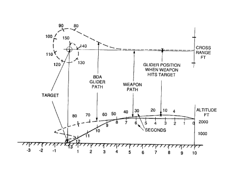
Fig. 1 illustrates a weapon deploying an all-aspect piggyback bomb damage
assessment system in accordance with the principles of the present invention;
Fig. 2a illustrates a first embodiment of the all-aspect piggyback bomb damage
assessment system of the present invention;
Fig. 2b illustrates a partial view of the system of Fig. 2a with wings
deployed;
Fig. 2c illustrates a rear end view of the system of Fig. 2a with tail fins
deployed;
Fig. 2d illustrates the bomb damage assessment system in an operable state
having its ballute and speed brakes deployed;
Fig. 2e illustrates a typical glide path of the all-aspect piggyback bomb
damage
assessment system of Fig. 1;
Figs. 3a-3c illustrate top, front, and exposed side views of a second
embodiment of the all-aspect piggyback bomb damage assessment system of the
present invention;
Figs. 4-15 illustrate graphs showing the performance of the all-aspect
piggyback bomb damage assessment system; and
Fig. 16 is a chart comparing the the present bomb damage assessment system
and a conventional parachute assisted assessment system.
DETAILED DESCRIPTION
Referring to the drawing figures, Fig. 1 illustrates a weapon 11 deploying an
all-aspect bomb damage assessment system 10 in accordance with the principles
of the
present invention. The all-aspect piggyback bomb damage assessment system 10
is
piggybacked or otherwise secured to a weapon 11, such as a missile 11 or bomb
11, in
a separate launch tube 12, for example. The system 10 may be stowed in a
horizontal
launch tube 12 and horizontally dispensed from the weapon 11 during its
flight, or
stowed in a lateral launch tube 12 and ejected from the weapon 11 during its
flight in
the manner of a mortar, for example. The all-aspect piggyback bomb damage
assessment system 10 is designed to provide imagery of a bombed area
immediately
after weapon delivery. Two different embodiments of the system 10 are
described
herein with reference to Figs. 2a-2d and Fig. 3a-3c, respectively.
Furthermore, two
versions of each of the bomb damage assessment systems 10 are described,
including
an all-aspect system 10, and a simplified single-aspect system 10.
Referring to Fig. 2a, details of one embodiment of the all-aspect bomb damage
assessment system 10 are shown. The bomb damage assessment system 10 comprises
CA 02173659 1999-06-25
a glider 20, having an eighteen-inch long body 21 with a two-inch circular
cross
section, for example. Spring loaded curved wings 22 fold on the top of the
body 21.
The wings 22 are provided with a dihedral shape that promotes roll stability
of the
glider 20. Four curved tail fms 23, driven by model airplane actuators 25,
such as a
5 model S9102 actuator 25 manufactured by Futaba Corporation, for example, are
provided that are designed to move 60 degrees in 0.13 seconds, for example, to
extend
the fins 23. Other suitable actuators 25 are readily available from commercial
model
airplane suppliers. A release mechanism (not shown) releases the spring loaded
wings
22 so that they extend and lock.
The glider. 20 comprises several subsystems including an imaging sensor
system 31, a guidance and flight control system 40, a data communications link
36,
and a programmable processor 35 for controlling the glider 20 and the other
subsys-
tems. The imaging sensor system 31 may comprise a video camera 31 or an
infrared
camera 31, for example. A suitable infrared camera 31 may be a 256x256 element
platinum silicide (PtSi) focal plane array cooled by a closed-cycle Stirling
cooler or
Argon gas, for example. The infrared camera 31 may be an InfraCam camera, manu-
factured by Inframetrics, for example. The glider 20 has a front optically
transparent
front window 32, which may be transparent to visible or infrared energy,
depending
upon the type of imaging sensor system 31 used in the system 10. The selected
camera
31 is mounted on an azimuth axis gimbal 33, which is electrically coupled to
the
processor 35, and which is designed to rotate the viewing angle of the imaging
sensor
system 31 in accordance with programmed instructions stored in the processor
35.
The data communications link 36 may be provided by a conventional radio
frequency data link 36 such as a 2 GHz low bandwidth data link 36. The data
link 36
may be a model T-2200-FM4-1 data link manufactured by Microtec Electronics,
for
example. A battery 34 is housed inside the body 21 of the glider 20 and
provides
power for the processor 35, the gimbal 33, the radio frequency data link 36,
and the
guidance and flight control system 40 including the actuators 25. The glider
ZO has a
tail section 26 that houses a deployable ballute 27 (shown deployed in Fig.
2d). In
addition, and in order to controllably decelerate the glider 20 a plurality of
speed brakes
28 (shown deployed in Fig. 2d) may be provided.
For the purposes of completeness, Fig. 2b illustrates a partial view of the
system 10 with wings 22 deployed, Fig. 2c illustrates a rear end view of the
system 10
with tail fins 23 deployed, and Fig. 2d illustrates the system 10 in an
operable gliding
state having its deployable ballute 27 and speed brakes 28 deployed. Referring
to Fig.
2e, it illustrates the operation of the glider 20 and the all-aspect piggyback
bomb
damage assessment system 10. More particularly, Fig. 2e shows the terminal
* Trademark
CA 02173659 1999-06-25
6
trajectory of the weapon 11 (solid traces), for example, and the trajectory of
the glider
20 (dashed traces), with time ticks to illustrate relative position. The
camera 31 is
designed to have a field of view of 30 degrees in elevation and 40 degrees in
azimuth,
for example. The centerline of this field of view is depressed by 10 degree,
for
examples. These parameters represent approximate angles that may be altered to
fit
different specific applications.
The glider 20 flies such that the hot spot caused by impact of the weapon 11
moves
downward in its field of view. When the hot spot reaches a predetermined
depression
angle relative to the enter of the field of view, the azimuth gimbal 33 is
controlled to
move slowly to the left, for example. A conventional hot spot tracker that is
part of the
guidance and flight contral system 40 develops an error signal when the hot
spot
moves to the right in the field of view, which causes the glider 20 to bank to
the right,
thus fuming the glider 20 to the right. When the desired bank angle is
reached, the rate
of turn of the glider 20 matches the rate of turn of the azimuth gimbal 33.
As the azimuth gimbal 33 approaches 90 degrees, it stops rotating relative to
the
body 21 of the glider 20. The existing bank angle to the right causes the
image of the
hot spot to move to the left in the field of view of the camera 31, generating
a signal
that causes the glider 20 to roll to the left. This roll continues until the
hot spot is
centered in the field of view of the camera 31, and the glider 20 banks to the
left. For
example, if the azimuth gimbal 33 stops turning at 80 degrees relative to the
centerline
if the glider 20, then the path follows an inward spiral with a 10 degree
inward pitch.
This inward spiral reduces the range to the hot spot and improves the linear
resolution.
Thus the target area is viewed from all aspects as the glider 20 flies around
the target
area, first at long range when the image includes a large amount of
background, and
progressively closer resulting in less background but finer linear detail of
the target
area.
In addition to hot spot tracking, the glider 10 of the present invention may
also
employ GPS (global positioning system) guidance. In this instance, the glider
20
includes a GPS receiver 29 that is integrated into the guidance and flight
control system
40. The target location in GPS coordinates is entered into the programmable
processor
and guidance and flight control system 40. When the glider 20 is released from
the
weapon 11, it may be programmed using the programmable processor 35 and
guidance
and flight control system 40 to fly along a specific path or geometric surface
in GPS
coordinates, such as along a converging cone centered in the coordinates of
the target,
35 for example. Such programming is well-known to those skilled in the art.
Referring to Figs. 3a-3c they illustrate top, front, and exposed side views of
a
second embodiment of the all-aspect piggyback bomb damage assessment system 10
of
2173659
the present invention. Fig. 3a illustrates deployment of one of the spring
loaded wings
22, in this case formed in the shape of a conventional glider wing that
rotates from a
stored position adjacent the body 21 to an extended position. The glider 20
may have
an eighteen-inch long body 21 with a two-inch circular cross section, for
example.
Spring loaded wings 22 having a sixteen-inch span, for example, fold on the
top of the
body 21. Fig. 3b shows a front view of the glider 20 illustrating both wings
22
deployed. The field of view of the camera 31 is shown. Fig. 3c illustrates the
internal
components of the system 10 discussed hereinabove. More particularly, the body
21
houses the camera 31 mounted on the azimuth axis gimbal 33, the battery 34,
the
processor 35, the data link 36, four actuators 25, and the inflatable or
deployable
ballute 27. The camera 31 is used to track the weapon 11 after launch to its
point of
impact, and thereafter to track the hot spot on the ground left by the
explosion. The
ballute 27 is cut free when the deceleration phase of the glider 20 is
complete. The
weight of the glider 20 including all of its internal components and
subsystems is about
five pounds.
A single aspect version of the bomb damage assessment system 10 is construct-
ed in the identically same manner as the all-aspect systems 10 described
above, but is
programmed to fly a path straight toward the target area behind the weapon 11
until a
predetermined depression angle of the hot spot is reached. At this point the
tracker in
the guidance and flight control system 40 commands the glider 20 to slowly
reduce the
depression angle to about 8 degrees, for example, the angle of attack for a
maximum
liR to drag ratio (IJD), and hold the hot spot at this angle until impact with
the hot spot
is achieved, thus providing a series of images during the flight. This low
cost version
of the all-aspect bomb damage assessment system 10 may utilize a low cost
video (T~
camera 31 instead of an infrared camera 31. In this version, parachute
supported flares
may be ejected over the target area to provide illumination at night.
In operation, the camera 31 operates at a rate of 30 or 60 Hz. Once every 3
seconds or so, a frame grabber that is part of the processor 35 places a scene
into
memory. The stored scene is then read out during the 3 second interval and is
transmitted by way of the data link 36 to a command center, for example. Upon
completion, another frame is grabbed and transmitted until impact with the
ground
occurs, resulting in a series of images that may be analyzed by command
personnel.
For extending the observation time of the damage aftermath caused by the
impact of the weapon 11 with a ground target, a reconfigurable glider 20 was
designed
and tested. In its compressed configuration,with wings 22, fail fins 23 and
ballute 27
stowed, the glider 20 may be stowed and tube-launched from a weapon 11, such
as is
shown in Fig. 1. Wrap around tail fins 23 shown in Fig. 2a are used as the
speed
CA 02173659 1999-06-25
8
brakes 28 and the ballute 27 is deployed to significantly reduce the air speed
of the
glider 20. The glider 20 may be equipped with an extendable ring wing 22
comprising
the wing 22 shown in Fig. 2a, for increased aerodynamic efficiency. The glider
20
may be may be tail-controlled to operate at a lift-to-drag ratio of about 4.5.
The glider
20 may be flown along a shallow glide slope at relatively slow speeds such
that it
observes the target area prior to, during, and after impact of the weapon 11.
The predicted kinematics of the glider 20 in providing bomb damage assessment
of the target area have been determined. Figs. 4-15 illustrate graphs showing
the
perforrtlance of the all-aspect piggyback bomb damage assessment system 10. In
view
of the data contained in these graphs, compared to conventional bomb damage
assessment techniques, the glider 20 provides longer observation times of the
target
area. Fig. 16 is a chart comparing the the present bomb damage assessment
system 10
and a conventional parachute assisted assessment system. In addition, the
glider 20
does not require a deployable parachute previously used to initiate its
vertical descent
above the target area. Consequently, issues of wind effects on the dynamic
behavior of
the parachute and its altered flight path are nullified.
The present invention provides high quality bomb damage assessment imagery
on a timely basis, typically within two to five minutes of the impact of the
weapon 11.
In a mufti-weapon attack, each weapon 11 is reported independently. The bomb
damage assessment system 10 is readily adaptable for use with many large
weapons
11, such as missiles or bombs including GBU-15, GBU-130, ALCM, GBU-24,
GBU-28,1DAM, JSOW, TSSM, Popeye, Mk-84, for example.
Thus there has been described new and improved bomb damage assessment
systems that may be carried and deployed by a weapon to provide imagery of a
bombed
target area before and after weapon impact. It is to be understood that the
above-
described embodiments are merely illustrative of some of the many specific
embodi-
ments which represent applications of the principles of the present invention.
Clearly,
numerous and other arrangements can be readily devised by those skilled in the
art
without departing from the scope of the invention.