Note: Descriptions are shown in the official language in which they were submitted.
CA 02225974 1997-12-24
1
PATENT
Attorney Docket No. 15485-20
Client Reference No. ZTS-96PA-057
METHOD AND APPARATUS FOR DETERMINING AN ALTERNATE
ROUTE IN A VEHICLE NAVIGATION SYSTEM
BACKGROUND OF THE INVENTION
The present invention relates to route determination
in a vehicle navigation system. More specifically, the
present invention determination of alternate routes, i.e.,
detours, when road conditions make an originally determined
route undesirable or impassable.
Because updating map databases with up-to-the-minute
information regarding road conditions is an exceedingly
challenging task (even for so-called intelligent
vehicle/highway systems), currently available vehicle
navigation systems often determine routes on which the user
may encounter unforeseen or unforeseeable obstacles such as,
for example, road construction or excessive traffic. In such
situations it is desirable for the navigation system to have
the capability to determine an alternate route "on the fly" to
avoid the obstacle.
Some systems rely on user input to the route
determination algorithms to determine routes which are most
likely to be the easiest and fastest, i.e., the optimum route.
By prospectively selecting appropriate route determination
criteria, the user can use her knowledge of actual road
conditions to facilitate determination of the best available
route. For example, the user may specify that the system make
maximum use of freeways, or, alternatively, that no freeways
be used at all. The user may also specify that the route have
a minimum number of turns, or that it be the shortest distance
between the source and the destination. In addition, the user
may specify that the route avoid all known obstacles such as,
for example, toll booths. Unfortunately, while this approach
provides some flexibility, it cannot anticipate and correct
for road obstacles for which the user has little or no
warning.
CA 02225974 1997-12-24
2
One approach to "on the fly" obstacle avoidance
allows the user to tell the system to prohibit an upcoming
maneuver in response to which the system determines a short
detour from the point of the prohibited maneuver back to some
subsequent point on the original route. This may be
understood with reference to Fig. 1. As the user is
proceeding east on road 102 along original route 104, she
notices that road 106 is closed to the right because of
construction. As a result, the right turn maneuver suggested
by the system has become impossible. By refusing the
indicated maneuver with the user interface, the user alerts
the system to the obstacle. The system then determines an
alternate route 108 based on the assumption that the right
turn maneuver from road 102 to road 106 is not allowed. This
results in the detour via roads 110 and 112 which leads back
to road 106 as soon as possible.
Unfortunately, the above-described approach is
problematic where, for example, the entire portion of road 106
between roads 102 and 114 is closed. Such a situation is
addressed by another approach which will be described with
reference to Fig. 2. As in the previous example, the user
alerts the system to the fact that the right turn maneuver
onto road 106 is not possible. However, according to this
approach, the system avoids the portion of road 106 between
the two successive maneuvers at the intersection of roads 102
and 106 (i.e., the right turn mentioned above), and the
intersection of roads 106 and 114 (a left turn). By ignoring
the road segments between the next two upcoming maneuvers, an
alternate route 202 is determined which avoids the problem
discussed above.
However, despite the apparent advantages offered by
each of these approaches, none allows the user to contribute
input as to the nature of the alternate route based on her
perception of the road conditions. Thus, none of the above-
described approaches is sufficient to adapt to the high degree
of variability of road conditions which may be encountered by
the user. A more flexible approach to "on the fly"
determination of alternate routes is therefore desirable.
CA 02225974 2000-04-28
3
SUMMARY OF THE INVENTION
The present invention provides a method and
apparatus for "on the fly" determination of alternate routes
in a vehicle navigation system which allows the user to
specify the portion of the original route to be avoided by the
alternate route. This enables the navigation system to
generate alternate routes which bear some relation to the
actual road conditions encountered by the user. That is,
based on her perception of the road conditions, the user may
specify a distance along the original route from the current
vehicle position which is to be avoided by the alternate
route. The system then adjusts one or more parameters
associated with each of the segments in the original route
within the specified distance such that when the alternate
route is generated, these segments will tend to be avoided.
According to one embodiment, the system increases
the cost associated with each segment in the portion of the
original route specified by the user. The amount by which
each cost value is increased varies according to its distance
from the vehicle's current location, i.e., the starting point
of the alternate route. That is, the closer a segment is to
the current vehicle position, the greater is its cost
increment. In this way, the alternate route determination
algorithm tends to completely avoid the original route
segments immediately following the starting point of the
alternate route with this avoidance tendency lessening
somewhat as the algorithm encounters segments which are
farther along the original route.
Thus, according to the invention, a method and
apparatus are described for determining an alternate route
from a new source location located on an original route to a
subsequent location on the original route using a vehicle
navigation system. A portion of the original route to be
avoided by the alternate route is determined beginning at the
new source location. The portion of the original route
includes a plurality of segments each of which has an original
parameter associated therewith. Selected ones of the original
parameters are adjusted thereby resulting in a plurality of
CA 02225974 2000-04-28
4
adjusted parameters. The alternate route is then determined
based in part on. the adjusted parameters.
A further understanding of the nature and advantages
of the present invention may be realized by reference to the
remaining portions of the specification and the drawings.
BRIEF DESCRIPTION OF THE DRAWINGS
Fig. 1 illustrates one approach for generating an
alternate route;
Fig. 2 illustrates another approach for generating
an alternate route;
Fig. 3 is a block diagram of a specific embodiment
of a vehicle navigation system for use with the present
invention;
Figs. 4A and 4B illustrate a specific embodiment of
the present invention;
Fig. 5,is a table of cost values corresponding to a
specific embodiment of the present invention; and
Fig. 6 is a flowchart illustrating a specific
embodiment of the invention.
DESCRIPTION OF THE PREFERRED EMBODIMENT
The present invention relates generally to commonly
assigned United States Patents No. 5,345,382 to Kao for
CALIBRATION METHOD FOR A RELATIVE HEADING SENSOR, No.
5,359,529 to Snider for ROUTE GUIDANCE ON/OFF-ROUTE STATE
FILTER, No. 5,374,933 to Kao for POSITION CORRECTION METHOD
FOR VEHICLE NAVIGATION SYSTEM, and No. 5,515,283 to Desai et
al. for METHOD FOR IDENTIFYING HIGHWAY ACCESS RAMPS FOR ROUTE
CALCULATION IN A VEHICLE NAVIGATION SYSTEM,
Fig. 3. is a block diagram of a specific embodiment
of a vehicle navigation system 10 for use with the present
invention. Sensors 12 and 14 and GPS receiver 18 are coupled
to computing means 20 through sensor/GPS interface 22. In
typical embodiments, mileage sensor 12 comprises an odometer,
and angular velocity sensor 14 comprises a gyroscope, or a
differential odometer coupled to the wheels of the vehicle. A
CA 02225974 1997-12-24
global positioning system (GPS) data receiver 18 is provided
for receiving signals from, for example, a satellite-based
navigation system. Data from sensor/GPS interface 22 is
transmitted to CPU 24, which performs calibration, signal
5 processing, dead-reckoning, vehicle positioning, and route
guidance functions. A database containing map information may
be stored in database medium 26, with software directing the
operation of computing means 20 stored in main memory 28 for
execution by CPU 24. Memory 28 may comprise read-only memory
(ROM), or reprogrammable non-volatile memory such as flash
memory or SRAM. System RAM 30 permits reading and writing of
the information necessary to execute such software programs.
Database medium 26 may comprise non-volatile memory, a hard
disk drive, CD-ROM, or an integrated circuit in which
digitized map information has been stored. Output controller
32, which may comprise a graphics controller, receives data
processed by CPU 24 and transmits the data to display console
40 which includes output communicator 34, usually comprising a
display screen with associated audio electronics and audio
speakers. The driver may input data, such as a desired
destination, through user interface 36, typically comprising a
keyboard.
The map database stored in database medium 26
preferably comprises positional data such as, for example,
latitude and longitude coordinates, to describe road
intersections or nodes, road segments, landmarks and points of
interest, and other geographical information. The data base
may further comprise data representing characteristics of
roads or places on the map, such as road and place names, road
features such as dividers, one-way restrictions, surface,
speed limit, shape, elevation, and other properties.
According to specific embodiments of the invention, the map
database includes cost values associated with individual nodes
and road segments. These cost values correspond to the
estimates of time intervals for traversing the respective node
or segment. Node cost values take into consideration such
information as, for example, whether the vehicle would
encounter oncoming traffic, thus delaying a left turn
CA 02225974 2002-07-29
6
maneuver. Segment costs reflect road segment characteristics
such as speed limit and segment length, both of which affect
the travel time along the Segment. Als~:~ as;soci.ated with each
road in the map database is a link class which relates to the
category or type of the road. For example, the highest level
category of the hierarchy is the link r_I_ass FREEWAY. The
lowest level includes the link classes FRONTAGE and MISC which
include, for example, frontage roads and alleys.
The vehicle navigation system of the present
invention is operable to generate a route from a source
location to a destination according to a variety of different
methods. Some examples of such methods are described in the
U.S. patents which are referred to above. In addition,
further methods for route generation which may be employed in
conjunction with the present inventz.on are described in
commonly assigned, copending Canadian Patent: Application
No. 2,224,745 entitled ROUTE GENERATION TN A VEHICLE
NAVIGATION SYSTEM, filed on 12 December 1997.
FIGS. 4A and 4B will serve to i7.lust:rate the
operation of a specific embodiment of the invention.
Initially, an original route 402 (along roads 404, 406, and
408) is generated by the vehicle nav~.gation system as
described above. As the user proceeds from source S along
road 404, she encounters excessive traffic (or any of a
variety of road obstacles) and activates a k:ey or a switch on
the user interface which informs the system that she wishes to
avoid a portion of original route 402. The display screen
progression is shown in FIG. 4B. As the user is proceeding
along road 404, the next upcoming maneuver, i.e., 1_eft turn on
road 406, is shown on display screen 410. When the user hits
the "avoid" key, she is presented with t:he AVOID CURRENT ROUTE
screen 412 in which she may scroll to a desired distance and
hit "enter". The distances may be in miles as shown.
Alternatively, the distances may be presented to the user as a
number of road segments, city block's, etc. According to
CA 02225974 1997-12-24
7
another embodiment, the user may directly input any desired
distance within a range.
Upon the user's selection of the distance, the
system generates an alternate route 414 and communicates a new
upcoming maneuver to the user (screen 416). In generating
alternate route 414 the system increases the cost associated
with selected ones of the segments in the portion of original
route beginning at the intersection of roads 404 and 418 and
extending the selected distance. The manner in which this is
accomplished according to a specific embodiment may be
understood with reference to Fig. 4A and table 500 in Fig. 5.
As shown in Fig. 4A, original route 402 includes segments 51-
513. In generating an alternate route, the cost associated
with each of these segments is increased by an amount shown in
table 500. The cost values in table 500 are measured in
seconds, but it will be understood that such costs may be
represented in a number of ways.
As shown in the table, as the segment numbers
increase, i.e., as the distance from the road obstacle
increases, the cost added to the segment cost associated with
each successive segment is gradually decreased to zero. The
decrement and rate of this decrease depends upon the distance
of the original route to be avoided as specified by the user.
Thus, the closer the segment is to the road obstacle, the more
likely that the alternate route generation algorithm will
ignore it because of the dramatic increase in cost.
Similarly, as the segments recede from the road obstacle, the
likelihood that the algorithm will ignore them decreases until
the alternate route includes a segment from the original
route, i.e., segment S9.
It will be understood that the above-described
embodiment of the invention may be modified to include the
manipulation of node costs in place of, or in addition to, the
manipulation of segment costs. Node costs are the costs
associated with traversing a map node such as, for example, an
intersection. The node cost for a particular intersection may
be determined without regard to a particular route. It may
also be determined to specifically reflect the traversal of
CA 02225974 1997-12-24
8
the intersection from one specific segment to another.
According to such an embodiment, node costs may be manipulated
in much the same way as shown in Fig. 5 with regard to segment
costs. The manipulated node costs may then be used to
determine the alternate route either in place of the segments
costs, or in addition to them.
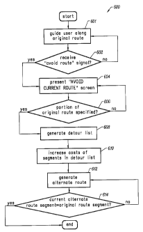
Fig. 6 is a flowchart 600 which illustrates the
operation of a specific embodiment of the invention. The
vehicle navigation system of the present invention guides the
user along an originally calculated route (step 601) unless it
receives an "avoid route" signal in response to input from the
user (step 602). The system then presents the user with an
"AVOID CURRENT ROUTE" screen as shown in Fig. 4B (step 604) so
that the user may specify how much of the original route to
avoid. Upon selection by the user of a portion of the current
route to be avoided (step 606), the system generates a detour
list which includes segments of the original route beginning
with the vehicle's current location and ending at the distance
specified by the user (step 608). For selected segments in
the list, the system then increases the costs associated with
each (step 610).
As discussed above with reference to Figs. 4A and 5,
the cost increment decreases as the distance between the
original road segments and the road obstacle increases. Once
the costs associated with the original road segments have been
increased in this manner, the system generates an alternate
route from the vehicle's current location, i.e., the location
of the road obstacle, to some subsequent location on the
original route (step 612). As discussed above, because of the
increased costs associated with the original route segments in
the detour list, the system tends to avoid expansion along
these segments with the alternate route determination
algorithm. This is especially true for the original route
segments closest to the beginning of the alternate route
because the greatest cost increase is associated with these
segments. However, the further the original route segments in
the detour list are from the current vehicle location, the
less likely they~are to be avoided by the search algorithm.
CA 02225974 1997-12-24
9
In this way, the alternate route determination algorithm
eventually includes a segment in the alternate route which
coincides with a segment in the original route. Once this
occurs, the algorithm terminates (step 614).
While the invention has been particularly shown and
described with reference to specific embodiments thereof, it
will be understood by those skilled in the art that the
foregoing and other changes in the form and details may be
made therein without departing from the spirit or scope of the
invention. For example, the invention has been described with
reference to a variable increment which is added to the
segment costs associated with the road segments in a specified
portion of the original route. It will be understood,
however, that these costs may be manipulated in a variety of
ways and remain within the scope of the invention. For
example, in contrast to table 500, the cost increment need not
be uniformly decremented for each successive segment in the
original route. Rather, the cost increment may be fixed for
several successive segments.
Moreover, for selected segments in the original
route, rather than increasing the associated segments costs,
access to such segments (e. g., the first five segments after
the road obstacle) may be completely prohibited. Fixed and/or
variable cost increments may then be added to successive
segments. Thus, a variety of segment parameters (e. g.,
segment cost) may be manipulated in a variety of ways for the
segments in the portion of the original route to be avoided by
the alternate route. In view of the foregoing, the scope of
the invention should therefore be determined by reference to
the appended claims.