Note: Descriptions are shown in the official language in which they were submitted.
CA 02257258 1999-08-30
COMPUTER AIDED ROUTING AND POSITIONING SYSTEM
Technical Field
This invention relates to .a new Computer Aided Routing and Positioning
System (CARPS) for travel planning, travel guidance, and recording travel
locations and paths during business or recreational use. The invention
provides
an interactive computer travel planning guide for determining a route between
a
user selected travel origin and travel destination following user selected
intermediate waypoints along the way. CARPS software determines the
preferred travel route within user selected constraints. The user can also
select
among a plurality of types of geographically locatable points of interest
(POIs)
within a user-defined region of interest along the travel route. A CARPS
database incorporates travel information such as graphics, photos, videos,
animations, audio and text information about the user selectable POIs along
the
way as well as about transportation routes and waypoints. From the user
selected and user-defined transportation routes, waypoints, and POIs along the
travel route, the CARPS software constructs a user customized multimedia
travelog for preview on a computer display of the user-defined travel route.
Based on the user customized previews, the travel route including
transportation
routes, waypoints, and points of interest can be updated or changed according
to the user preferences and choices. Modified travel routes can be previewed
with further multimedia travelogs until a satisfactory travel route is
achieved.
The CARPS software user can then output a travel plan, i.e, downloading
waypoints electronically and/or printing out maps with route indications and
text
travel directions.
1
CA 02257258 1999-08-30
WO 97/48065 PCT/US97/09989
The CARPS is also applicable for use with the Global Positioning System
(GPS), radio location systems, dead reckoning location systems, and hybrid
location systems. For example, the GPS satellite system is used with a GPS
receiver for displaying waypoint data and limited routing data of the CARPS
user
on the computer display for correlation of location with surface features or
mappable features. Data generated by the GPS receiver may be used for "real
time position updates" in the CARPS computer display or may be recorded by the
GPS receiver in the field for subsequent downloading to CARPS software and
CARPS computer display. As well, CARPS-generated data may be used within the
GPS receiver by a CARPS user for guidance in the field apart from a desktop
CARPS platform. The user can follow the CARPS generated route using just a
GPS device alone, or with the further aid of other CARPS output such as
printed
maps. This can be accomplished visually and intuitively between human readable
forms of a map without the necessity of a users physical determination of
latitude
and longitude and without requiring any mathematical calculations by the user.
Text and voice or audio outputs can be provided to facilitate use and reading
of
the printed maps and/or GPS devices. The invention also adds a communications
dimension to the maps for adding and updating the latest spatially related
data, for
providing software tools for map analysis and reading, and generally for
communications between computer systems and devices and between users in a
variety of combinations.
Background Art
A variety of computer hardware and software travel planning aids are
currently available on the market primarily for vacation and recreational
travel
planning. A number of the travel guide software packages focus on National
Parks of the United States or recreational tours and activities with prepared
travelogs or prepared assemblages of multimedia travel information on the
different recreational geographical locations or recreational activities. Such
travel
software programs are exemplified for example by the America NavigaTour (TM)
MediAlive (TM) multimedia travel guide produced by CD Technology, Inc.; the
Great Vacations (TM) Family Travel Guide by Positive Software Solutions; the .
2
CA 02257258 1998-12-04
WO 97/48065 PCT/LJS97/09989
Adventures (TM) CDROM Program for worldwide adventure travel by Deep River
Publishing, Inc.; and National Parks of America, a CDROM product of Multicom
Publishing, Inc. which contains a directory of all National Parks in the
United
States.
Rand McNally produces a software travel planning product under the
trademark TRIPMAKER (TM) for planning a trip by car in the United States,
Canada, and Mexico. The Rand McNally Tripmaker (TM) software also calculates
quickest, shortest, and preferred scenic routes for the trip planner. While
the Rand
McNally product incorporates a database of many points of interest, the
70 multimedia travelog information appears limited to preplanned scenic tours.
Similarly the American Automobile Association in cooperation with
Compton's NewMedia also provides travel planning from starting point to
destination point with stopping points in between. The CDROM product contains
a
database of travel information. However the multimedia information available
from
the database appears limited to "suggested routes of travel" again limiting
user
choice.
In each case it appears that travel information from multimedia sources is
preassembled by editors so that the user or trip planner is limited to
"canned" or
prepared multimedia travelogs of prescribed, suggested, or preplanned tours.
Or
the user is limited to information fragments about this or that particular
object of
interest or this or that particular place. There is no opportunity or user
capability
and selectivity in constructing a user customized travelog of assembled
multimedia
information for previewing a particular user determined route of travel. The
user is
relegated to travelogs and multimedia assemblages prepared for routes and
tours
proposed by other editors. The first release in July 1994 of Map'n'Go (TM)
Atlas
of North America on CD-ROM by DeLorme Mapping Freeport ME 04032 includes a
version of CARPS that limits the nodes or routable waypoints to specified
intersections of selected roads and highways, and car ferry terminals.
Belatedly, there are a variety of mapping and positioning systems. One
such system is a hand-held personal GPS navigation tool that has been
developed
by the Garmin Corporation of Lenexa, Kansas under the tradename Garmin GPS
45. The Garmin navigation tool incorporates a GPS receiver and a limited
3
CA 02257258 1998-12-04
WO 97148065 PCT/US97I09989
character display screen for displaying position information in alphanumeric
and
graphic characters. Another such system is a hand-held personal GPS navigation
tool that has been developed by Trimble Navigation of Austin, Texas, under the
trademark Scout GPS (TM). The Trimble navigation tool incorporates a GPS
receiver and a four-line character display for displaying position information
in
alphanumeric characters. This hand-held GPS system can apparently display
alphanumeric position information in a latitude/longitude coordinate system or
a
Universal Transverse Mercator (UTM) coordinate system. The Trimble navigation
tool can apparently also display proprietary coordinate system information for
locating the position of a user on a standard topographic map. The Trimble GPS
navigation tool displays in alphanumeric characters the horizontal and
vertical
coordinate distances of the user from the southeast corner or southeast
reference
point of any standard topographic map.
A disadvantage of the Trimble GPS navigation tool is that it provides a
display of coordinate system data only in alphanumeric characters on a
multiline
LCD display. The user must then perform mathematical measurements and
operations to determine the user location on a particular topographic map.
While
the incorporation of GPS technology provides an improvement over dead
reckoning and position estimation from topography, it necessarily requires
user
reference to quantitative measurements and calculations. Furthermore, the
Trimble
navigation device does not provide communications access to other geographical
information databases for updated information on geographical objects in the
spatial area of interest or communications access to other software tools for
map
analysis and reading. More generally, the Trimble navigation device does not
provide a communications dimension for the map reading system.
Silva Sweden AB and Rockwell International USA have developed a hand-
held GPS compass navigator for use on any standard map. The GPS compass
navigator incorporates a GPS receiver for locating the user on any standard
map.
A built-in "compass" gives range and bearing from the known user position to a
specified destination. This information is updated on the GPS compass
navigator
as the user progresses toward the destination. The GPS compass navigator is
described as being in the form of a guiding "puck" that apparently rides or is
4
CA 02257258 1998-12-04
WO 97/48065 PCT/US97/09989
moved over the standard map at the user location. It therefore cannot display
multiple geographical objects at the same time and cannot communicate with
other sources of spatially related map information.
Prior-art attempts at combining a GPS device with electronic maps exist, but
these attempts have not been able to provide GPS devices with optimized
routing
data used independent from the electronic maps. Accordingly, there is a need
to
link GPS devices with travel planning, map display, and customization of
routes so
that GPS devices may provide remote guidance along optimized routes. On-site
locational information which may be recorded or tracked by the GPS device in
the
field should be transferrable to a routing and positioning system. As well, a
routing and positioning system should be able to generate information that is
transferrable to a GPS device. Such objects will become apparent with
reference
to the present invention as described below.
Objects of the Invention
It is therefore an object of the present invention to provide a new computer
aided routing and positioning system (CARPS) capable of determining a travel
route between a user-selected travel origin and travel destination following
user-
selected waypoints of interest along the way. A feature of the invention is
that the
user can construct a highly selective travel route incorporating waypoints
selected
by the user.
Another object of the invention is to provide a database of geographically
locatable objects or points of interest (POIs) organized into a plurality of
types for
selection by the user. The database also incorporates travel information
selected
from a range of multimedia sources about the transportation routes, waypoints,
and geographically locatable objects of interest along the travel route. A
feature of
the invention is that the objects of interest are encompassed within a user-
defined
region of interest of user specified dimensions along the travel route.
Still another object of the invention is to provide CARPS software capable of
presenting a user customized travelog or sequential assemblage of multimedia
information for preview on the computer display about the user-defined travel
route. The travelog includes multimedia information about the transportation
route,
5
CA 02257258 1998-12-04
WO 97/48065 PCT/US97/09989
waypoints, and selected POIs in the user-defined region of interest along the
travel
route.
A further object of the invention is to provide a CARPS for use with radio
location systems, dead reckoning location systems, and hybrid location systems
for displaying user location. For example, the GPS satellite system can be
used
for displaying the location, direction of travel, route, speed, and other
travel data of
a CARPS user on a generalized grid quadrangle for correlation of user location
on
a coinciding printed map. Such is accomplished by direct sensory, visual, and
intuitive methods. As well, the GPS satellite system may be used in the field
for
recording waypoint data and limited routing data of a CARPS user for later
data
transfer and CARPS computer display. Additionally, the GPS satellite system
may
be used in the field for updating waypoint data and limited routing data of a
CARPS user for immediate data transfer via wireless data communications and
remote CARPS computer display at a CARPS desktop platform.
A feature of the invention is that the trip planner is no longer relegated to
the prescribed or suggested routes and tours of other editors for previewing
travel
routes. Nor is the trip planner limited to adhoc or fragmented multimedia
information about this or that object of interest. Rather, the user constructs
a user-
defined travel route including transportation routes, waypoints, and POIs
within a
region of interest along the travel route. The CARPS software responds by
assembling a user customized travelog or sequential assemblage of multimedia
information for previewing the entire trip. The travel route including
transportation
routes, waypoints, and objects or points of interest can then be changed if
necessary to suit the user preferences and choices.
An advantage of the invention is that travel planning can be optimized in an
iterative process. The user constructs a travel route and at the same time the
user
constructs a customized travelog for previewing the initial travel route. On
the
basis of the multimedia preview of the initial travel route the trip planner
undertakes revision of the travel route, e.g. by changes in the selected
transportation routes, waypoints, and selected POIs. The travel route is
recalculated by the CARPS software and the user customized travelog is also
reconstructed for further preview. Further refinements can follow in
subsequent
s
CA 02257258 1998-12-04
WO 97/48065 PCT/US97/09989
iterations until a satisfactory travel route is achieved.
Another advantage is that CARPS users in the field may simultaneously
navigate a travel route generated by CARPS software while recording or
tracking
locations or sequences of locations. Such locations may be designated by the
user as new POI's and sequences of locations may be transferred from the GPS
receiver to the CARPS desktop platform as an ordered waypoint list that
designates a new travel route. Further, fast and accurate surveying is enabled
from GPS receiver location recording data made by the user in the field when
transferred to the CARPS desktop platform for computerized data mapping by the
CARPS software.
Disclosure of the Invention
!n order to accomplish these results the present invention provides CARPS
for use with a digital computer, digital computer display, and a detachable
handheld GPS device such as a Garmin GPS 45 Personal Navigator (TM) which
provides waypoint list managment tools and compass bearing, distance, speed of
travel, estimated time until arrival, and other information in relation to the
next
waypoint on an overall route. A variety of other peripheral equipment is also
provided as hereafter described. A set of electronic maps is provided for
presentation on the computer display. The electronic maps depict
transportation
routes having route intersections and identified waypoints at geographical
locations along the transportation routes. The route intersections and
identified
waypoints depicted on the electronic maps are identified in the computer by
coordinate locations of a selected geographical coordinate system.
A CARPS database contains geographically locatable objects (loc/objects)
also referred to as points of interest (POIs) identified by coordinate
locations in the
geographical coordinate system. The POIs are organized into a plurality of
types
for user selection of loc/objects or POIs individually and by type. The
loc/object or
POI types constitute electronic overlays of the database for display over the
electronic maps on the computer display. As used in this specification and
claims,
the phrase points of interest or POI's is generally used to refer to
loc/objects for
which multimedia information is available for describing the POI's and
presenting
7
CA 02257258 1998-12-04
WO 97/48065 PCT/US97/09989
the points of interest in a multimedia travelog as hereafter described.
Typically, the CARPS database is a geographical information system or GIS.
Such a GIS manages data in the GIS database in relation to the geographical
coordinate locations of the selected geographical coordinate system. Thus, the
CARPS database manager relates points of interest and any other loc/objects of
the database with particular locations on or near the surface of the earth in
terms
of coordinate locations such as latitude and longitude. The multimedia
information
hereafter described is similarly identified with the coordinate location of
the subject
POIs.
The computer aided routing and positioning system incorporates (CARPS)
software constructed for user travel planning using the electronic maps
presented
on the computer display. The CARPS software permits user selection of a travel
origin, travel destination, and desired waypoints between the travel origin
and
travel destination. The CARPS software calculates, delineates and displays a
travel
route between the travel origin and the travel destination via the selected
waypoints. The travel route is calculated according to user choice of the
shortest
travel route, quickest travel route, or user determined preferred travel
route. As
used in the specification and claims, waypoints refers to the origin and
destination
of a possible route and intermediate points or places along the way including
major road and highway intersections, joints or turning points at connected
short
line segments of major roads and highways, place names situated on major roads
and highways, and as hereafter described, POIs near the major roads and
highways.
The CARPS software permits user selection of an area or region of interest
along the user-defined travel route. The area or region of interest is defined
by
user specified dimensions and may be for example a corridor of specified width
along the travel route, circles of specified diameter at locations along the
travel
route, or regular and irregular polygons, etc. The CARPS software permits user
selection of specified POI types within the user-defined region of interest
and user
selection of particular POIs from the selected types within the region of
interest.
The region of interest is identified in the computer by coordinate locations
of the
geographical coordinate system.
8
CA 02257258 1998-12-04
WO 97/48065 PCT/US97/09989
The CARPS database also incorporates travel information about the POIs
identified in the database and about selected transportation routes and
waypoints
of the electronic maps. The travel information may be from a variety of
multimedia
sources and is for example selected from the group consisting of graphics,
photos, videos, animations, audio and text information, etc. As hereafter
described
the multimedia travel information is subject to a high degree of user
selectivity in
composing customized multimedia travel information packages.
The CARPS software is also constructed to present a user customized
travelog for preview on the computer display of the user-defined travel route.
Thus
multimedia travel information is assembled from the CARPS database on the
transportation routes and waypoints of the electronic maps and the selected
POIs
of the database in the user-defined region of interest along the travel route.
A feature and advantage of CARPS is that the travel planner can preview on
the computer display a travelog particularly customized for the user-defined
travel
route including multimedia information on the transportation routes,
waypoints, and
POIs selected by the user. The trip planner is not constrained to viewing
"canned"
or preselected multimedia assemblages and travelogs for suggested routes
planned by other editors. Rather CARPS delivers a user customized travelog or
multimedia information assemblage directed specifically to the user-defined
travel
route including the user-selected transportation routes, waypoints and POIs.
As a result of this preview, the trip planner can revise the travel route
including transportation routes, waypoints, and POIs. The CARPS software then
recalculates the travel route affording further opportunity for selecting new
or
different POIs in the newly defined region of interest along the new travel
route. A
new multimedia travelog preview is assembled corresponding to the new travel
route and the process is repeated until the user achieves a satisfactory
travel route
based on the iterative trip planning process and multimedia previews made
available by the invention.
A feature of the invention is that one or more points of interest in the user-
defined region of interest along a travel route can be converted by the user
to
waypoints on a new travel route. The POI status therefore changes from a
possible side excursion off the main travel route to an actual waypoint on the
new
9
CA 02257258 1998-12-04
WO 97148065 PCT/US97/09989
or revised travel route. The user therefore has available a wide selection of
possible sites for defining a travel route including route intersections,
named
places on the electronic map, and the array of geographically locatable
objects
about which there is multimedia information and therefore referred to as
points of
interest of the CARPS database.
In the preferred example the CARPS software is constructed to display a
user customized strip map of the user-defined travel route. The user
customized
strip map is typically displayed along the center of the computer display.
User-
selected POIs in the user-defined region of interest are listed along one side
of the
strip map with pointers to respective POI locations in the region of interest.
Travel
directions for the travel route are listed along the other side of the strip
map with
pointers to respective intersections corresponding to directions along the
travel
route.
Preferably the strip map is vertically oriented with the travel origin at the
bottom of the strip map and travel destination toward the top of the strip
map. An
advantage of this arrangement is that the strip map and travel route are
always
oriented in the direction of travel and the right and left directions coincide
with
actual right and left directions.
In the preferred example the digital computer also incorporates a printer
and the CARPS software is constructed for printing hardcopy maps of the user
customized strip maps. The hardcopy maps of the user customized strip maps
show the travel route, list of POIs and pointers along one side of the strip
map,
and list of directions and pointers along the other side of the strip map. The
printed hardcopy map is preferably vertically oriented also with the travel
origin at
the bottom of the strip map and travel destination toward the top of the strip
map.
The electronic maps, CARPS database, and CARPS software are typically
stored on a CDROM and the digital computer incorporates a CDROM drive. The
CARPS software may include a replace function for updating the electronic maps
and CARPS database on the CDROM with replacement or supplemental
information from another memory device.
CARPS works with a geographic information system or GiS managing data
in relation to specific geographic coordinates. The GIS enables display of
CA 02257258 1998-12-04
WO 97/48065 PCT/US97/09989
electronic maps which function as a user interface as well as a system for
display
of geographic data. The GIS and the mapping interface coordinate two broad
types of data: (1) transportation routes or networks and nodes or waypoints
subject to routing computations; and (2) POIs or loc/objects related to
information
about travel and locations in various media.
Transportation routes depicted on the electronic maps may include all forms
of transportation routes for example selected from the group consisting of
vehicle
routes, ferry routes, air travel routes, bicycle routes, and hiking traits.
Such routes
are typically represented as line segments, vectors or networks appropriate to
the
modes of transportation involved. The GIS and the user manage and manipulate
such routing data in terms of geographic points including intersections,
terminals,
junctions and connections, generally labelled "nodes". Particular travel plans
or
itineraries along available transportation routes entail specific selections
and
arrangements of nodes called "waypoints". Users enter or list waypoints in the
order of an intended journey including a point of departure, optionally
intermediate
stops or places to pass through on the journey, plus a final destination. In
summary, nodes comprise the possible waypoints from which the user composes
waypoint lists or input for routing.
Nodes and waypoints for routing, as well as POIs associated with
multimedia information, are all related in the GIS database to geographical
coordinates corresponding to particular locations on or adjacent to the
earth's
surface. The selected geographic coordinate system may be for example the
latitude/longitude (lat/long) geographical coordinate system. Coordinate
locations
which correspond to specific nodes, waypoints or POIs are then stored in the
digital computer as lat/long coordinates. In some cases, POIs and nodes
coincide
or share a particular location or set of geographic coordinates. POIs relate
to
multimedia information on locations, however, white nodes and waypoints relate
to
routing.
CARPS permits the user to locate, click on or otherwise choose such nodes
or possible waypoints and POIs in order to develop his or her individual
travel
plan. The CARPS software is also constructed for incorporating POIs selected
by
the user, while playing related multimedia in the region of interest, as new
11
CA 02257258 1998-12-04
WO 97/48065 PCT/US97/09989
waypoints in the user-defined .travel route. The CARPS software can then
recalculate, delineate and display a new user-defined travel route via the
selected
loc/objects or points of interest treated as added waypoints. The CARPS
database
or GIS also stores information about the transportation routes entering and
leaving
the respective waypoints as well as the identity of immediately adjacent
nodes.
According to the invention POI types of the CARPS database may be
selected for example from the group consisting of restaurants, hotels/motels,
cities,
municipalities, settlements, routes, transportation services such as airports,
ferries,
and railroads, parks, recreation areas, campgrounds, hospitals, zoos, museums,
tourist and sightseeing attractions, other geographical landmarks, etc. In a
simplified example, the POI types can be limited to hotels, campgrounds,
restaurants, and selected tourist attractions.
Data items of the various types of POIs are stored, managed and
manipulated within the CARPS database or GIS in relation to one or more media
from the group of alphanumeric text, still or moving graphics and audio
including
voice, natural and artificial sound. For an example, a typical hotel POI item
includes information of interest to travelers about the accommodations, room
prices, other facilities and nearby recreational and cultural attractions in a
variety of
selectable text, audio and pictorial media.
The invention also provides a set of printed maps substantially coinciding
with the set of electronic maps for user cross reference, correlation and
coordination between the computer display presented electronic maps and the
printed maps. A grid system of grid lines preferably overlays the electronic
maps
and the printed maps. The grid lines define uniquely named grid quadrangles.
The uniquely named grid quadrangles of the electronic maps and printed maps
substantially coincide in geographic areas depicted by the grid quadrangles to
facilitate cross reference, correlation and coordination between the computer
display map presentations and the corresponding printed maps, as set forth in
further detail in the related patent application cross referenced above.
The electronic maps and printed maps are constructed to be substantially
constant-scale maps. The electronic maps may be at a plurality of scales, each
scale level incorporating substantially constant-scale maps. In that case the
grid
12
CA 02257258 1998-12-04
WO 97/48065 PCT/US97/09989
system also incorporates a plurality of sets of grid lines corresponding to
the
respective scales and defining uniquely named grid quadrangles at each scale.
The CARPS software is constructed to permit user scrolling across grid
quadrangles at the same scale and to permit zooming between grid quadrangles
at different scales. The scrolling and zooming steps are displayed on the
computer display. Further details on the scrolling and zooming capabilities of
the
mapping database manager are set forth in the David M. DeLorme U.S. Patent No.
4,927,319 issued November 20, 1990 for ELECTRONIC GLOBAL MAP
GENERATING SYSTEM and the David M. DeLorme U.S. Patent No. 5,030,117
issued July 9, 1991 for DIGITAL GLOBAL MAP GENERATING SYSTEM. The digital
computer may be selected from a range of hardware either portable or
stationary
including PDA's, notebooks, portable computers, GPS receivers, desktop
computers, workstations, and mainframes.
Generally the CARPS software of the invention is constructed so that the trip
planner can easily change any of the user-selected parameters such as user-
selected travel origin, travel destination, transportation routes, and
waypoints.
POI's can also be incorporated as waypoints along the route. The CARPS
software recalculates, delineates, and displays on the computer display the
revised
travel route. It also assembles and displays a revised user customized
multimedia
travelog for previewing the revised travel route. Waypoints may be selectively
uploaded or downloaded between GPS receivers and CARPS software. These
steps can be repeated in an iterative trip planning process until the user
arrives at
a satisfactory user-defined travel route.
In the preferred example, the CARPS software is composed of a routing
subsystem, a multimedia subsystem, and an interactive mode for interaction
between the two subsystems. The routing subsystem performs the travel planning
and routing functions, calculating and displaying a route according to user
specified choices and constraints. The multimedia subsystem performs
multimedia functions, retrieving and displaying multimedia information about
selected POI's. In the interactive mode, the multimedia subsystem constructs a
travelog following the user-defined route calculated by the routing subsystem.
13
CA 02257258 1998-12-04
WO 97/48065 PCTlUS97/09989
Alternatively or in addition, a radio location receiver such as a GPS receiver
is coupled .to the CARPS software. The CARPS software can be programmed to
display the location of a user based on signals from the GPS receiver or other
radio location receiver in a selected grid quadrangle image. A full screen can
be
constituted to be the selected grid quadrangle. Or, multiple grid quadrangles
may be displayed. The GPS receiver can also be used in conjunction with CARPS
map displays and printed maps without grid quadrangles. The user correlates
and
coordinates locations on the grid quadrangle computer display with locations
on a
corresponding grid quadrangle of a printed map. Additional travel data can
also
be displayed including user direction of travel, velocity, altitude, and route
traveled,
all derived from the GPS receiver or other radio location receiver. In
addition to
radio location, other user location systems may also be incorporated into the
CARPS such as dead reckoning location systems that measure user location from
a known origin. Hybrid location systems are also available combining radio
location and dead reckoning.
The CARPS user can be provided with communications links for on-line
communication and transfer of spatially related data and software tools for
map
reading between computers and between users. For example a CARPS user may
communicate with another CARPS system or user for transfer of user location
data
and any other spatially related data. The CARPS user can communicate with
external databases, a central communications service bureau, and on-line
mapping
services for latest information relating to loc/objects, routes, and map
modifications, priority messages, etc.
According to another preferred embodiment of the invention, the CARPS
software is coupled to a radio location receiver such as a loran receiver or a
GPS
receiver for generating signals corresponding to the geographical coordinate
location and direction of travel of a CARPS user. Dead reckoning location
systems
and hybrid location systems may also be used. The database manager is
constructed for displaying on the CARPS computer display the location,
direction
of travel, speed and traveling route of the CARPS user. The displayed location
and route can be correlated with locations on the printed map coinciding in
geographic area with the selected grid quadrangle. The GPS receiver loaded
with
14
CA 02257258 1998-12-04
WO 97!48065 PCT/US97/09989
CARPS data can be used in a separate and independent CARPS system without
any databases of loc/objects as a stand-alone system or in combination with
the
second database and other available internal and external databases for
display of
selected loc/objects from such databases. CARPS and users can exchange data
for display or other use such as user location information as well as other
spatially
related data. This is accomplished over a variety of communications links,
wired
or wireless, adding a communications dimension to the CARPS.
While the description of the present invention is primarily directed to the
applications of the invention for computer-aided map reading, analysis and
interpretation and for supplementing the maps with spatially related data from
databases derived from memory devices and communications links, the invention
is also applicable for map making and map creation. A detachable, portable GPS
receiver can be used to record waypoints in the field for later downloading
into
CARPS for display and processing. Thus, the GPS receiver may communicate
GPS location data from on-site geocoding to a home office CARPS system for
accumulation and assembly of mapping data. At the same time the invention can
provide on-line mapping information services to other CARPS systems and users.
The invention also provides a new Computer Aided Routing and Positioning
Method (CARPM) using a digital computer with computer display and electronic
maps in combination with a GPS receiver for portable waypoint guidance,
updating, and recording. As noted above, the electronic maps include
transportation routes, route intersections and identified waypoints along the
transportation routes. The method also uses CARPS software for user travel
planning.
The method steps of the invention include presenting the electronic maps
on the computer display, selecting waypoints by using the electronic maps, or
by
list-based sources for locating by place names, zip codes or telephone
exchange
data etc., or by responding to related multimedia about proximate points of
interest, or by recordation via a geocoding device. The waypoints include a
user
travel origin and travel destination, and intermediate waypoints of interest
at
geographical locations between the travel origin and travel destination. The
method steps further include calculating, delineating, and displaying on the
CA 02257258 1998-12-04
WO 97/48065 PCT/US97/09989
computer display a travel route between the user travel origin and travel
destination via the user-selected waypoints of interest according to user
choice of
the shortest travel route, quickest travel route, or user-selected preferred
travel
route.
The method proceeds by selecting a region of interest to the user along the
user-defined travel route, and defining the region of interest by user-defined
dimensions limiting excursions on either side of the user-defined travel
route. The
method uses a database of geographically locatable points of interest in the
geographical areas of the electronic maps. The POIs are organized into a
plurality of types for user selection of POIs by type. The POI types provide
overlays of the CARPS database for display over the electronic maps on the
computer display. The database also includes the travel information selected
from the group consisting of graphics, photos, videos, animations, audio
information and text information about transportation routes and waypoints of
the
electronic maps and points of interest of the CARPS database.
According to the method, further steps include identifying in the digital
computer the transportation routes, route intersections, and waypoints of the
electronic maps, corridor of interest selected by the user, and the POIs of
the first
database, by coordinate locations in a common geographical coordinate system;
selecting specified POI types in the user-defined corridor of interest along
the user-
defined travel route and selecting particular points of interest from the
selected
types in the corridor; and assembling and displaying on the computer display a
user customized travelog for preview of the user-defined travel route, said
travelog
including travel information in the database on the transportation routes and
waypoints of the electronic maps and selected POIs in the user-defined
corridor of
interest along the user-defined travel route.
The invention also contemplates steps of changing the user-selected travel
origin, travel destination, transportation routes, or intermediate waypoints;
recalculating, delineating, and displaying on the computer display a revised
travel
route; and assembling and displaying on the computer display a revised user
customized travelog for previewing the revised travel route.
16
CA 02257258 1998-12-04
WO 97/48065 PCT/US97/09989
According to another feature of the system and method, points of interest
selected by the user within the user-defined region of interest along a user
determined travel route can be converted to waypoints. This may be
accomplished via a GPS receiver by which a user records waypoint data in the
field for subsequent downloading to the CARPS desktop platform. The travel
route
is then modified to incorporate the selected points of interest as actual
waypoints
in a new or revised travel route. The selected POIs then have a new status in
the
proposed travel plan. Rather than merely possible destinations reached by side
excursions from the designated travel route, they actually become waypoints on
the travel route. The routing algorithm or routing procedure of the CARPS
software therefore determines the shortest route, quickest route, or user-
defined
preferred route through the selected POIs as waypoints on the travel route.
An advantage of CARPS is the availability of an array of multimedia
information for points of interest and places in an area of interest. A user
can
therefore initially browse through the available information before. even
attempting
an initial route. The array of multimedia information can then provide a basis
for
selecting an initial route with destination and waypoints. Once establishing
an
initial route the user can then follow the interactive and iterative
procedures of
CARPS.
Other features of the system and method are set forth in further detail in the
following specification and accompanying drawings.
Brief Description of the Drawings
FIGURE 1A is a diagrammatic perspective view of an operating system and
system user showing CARPS according to the present invention.
FIGURES 1 B-1 M, 1 O and 1 P illustrate example screen displays and user
interfaces for CARPS while FIGURE 1 N illustrates an example hard copy
printout
of a travel plan prepared by CARPS.
FIGURE 2 is an overall block diagram of the interactive CARPS system
combining routing and travel operations with multimedia information
operations.
FIGURE 3 is a flow chart showing the operational steps and user options
available to multimedia users of CARPS.
17
CA 02257258 1998-12-04
WO 97/48065 PCT/US97/09989
FIGURES 4A,4B, and 4.C are assembled to form a flow chart showing the
operational steps and user options available to travel planning and routing
users of
CARPS. The flow chart assembled by FIGURES 4A,4B, and 4C is referred to in
the specification as FIGURE 4.
FIGURE 5 is an example of a map display presented to the user on a
monitor display by CARPS.
FIGURES 5A,5B and 5C are simplified screen displays showing alternative
strategies and methodologies for circumscribing points of interest within
respective
defined areas of a selected travel route.
FIGURES 6A and 6B are assembled to form a flow chart showing the
operational steps of CARPS for transforming a routing waypoint list or list of
nodes
of a selected route into a list of points of interest within defined areas
along the
selected route.
FIGURES 7A,7B, and 7C are assembled to form the flow chart referred to in
the specification as FIGURE 7 showing the user controls and commands made
available to the multimedia user of CARPS.
FIGURES 8A-8E further illustrate the flexible user controls and commands
for multimedia related operations of CARPS.
Descrietion of Preferred Examele Embodiments and Best mode of the
invention
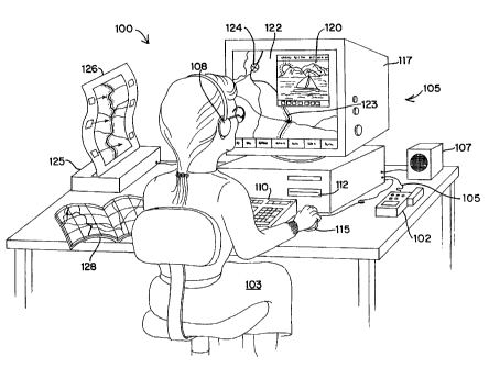
CARPS 100 according to the present invention is illustrated by way of
example in FIGURE 1A. A user 103 operates the software system 100, provided
on CD-ROM, utilizing a desktop personal computer equipped for multimedia. In
the preferred embodiment, illustrated in FIGURE 1A, the personal computer
system 105 includes a 286, 386, 486, or Pentium (TM) Intel (TM) processor or
equivalent, with typical memory devices, associated circuitry and peripheral
devices including a monitor or cathode ray tube (CRT) 117, a speaker or audio
system 107, a printer 125, a CD-ROM player 112, a mouse 115 or similar
pointing
device, and keyboard 110. Alternatively, the software system 100 can be
provided
on diskette, run from a hard drive or central server (e.g. a local area
network
internally linked to a mainframe or externally linked to the Internet).
18
CA 02257258 1998-12-04
WO 97/48065 PCT/US97/09989
Included for use with CARPS 100, a GPS (or similar geocoding) device is
shown. An GPS/CARPS interface 105 between the GPS device and CARPS is
provided to allow data transfer between CARPS and the GPS device. The
GPS/CARPS interface 105 is preferably plug-in wiring. However, GPS/CARPS
interface 105 may be any type of hardware that allows data transfer may also
be
used including wireless infrared data transfer devices, modem type of data
transfer
devices, and data transfer by intermediate memory storage devices (e.g.
diskettes,
tapes,...etc.). The inclusion of the GPS/CARPS interface for use with the GPS
device makes it possible for the CARPS user to record data with the GPS device
at
a location remote from the CARPS desktop embodiment for later download of the
recorded data to CARPS. As well, data generated by the user with CARPS can be
uploaded to a GPS device through the GPS/CARPS interface. Such uploaded
data may be used for GPS guidance of the user along a CARPS-generated route.
As well, the GPS receiver can upload real-time information on its current
location
for processing and display in CARPS.
Alternative embodiments could include other input devices e.g. voice
recognition system, joystick, touch-screen, scanner for printed map input,
simplified keypad, etc., not represented here. FIGURE 1A discloses CARPS 100
implemented on a single, stand-alone, desktop style, personal computer. The
software technology, which facilitates interactivity between routing and
multimedia,
also works on a more portable laptop or notebook computer, a handheld personal
digital assistant (PDA), embedded in a travel planning appliance or an in-
vehicle
navigation system, as well as on mainframes of various kinds, distributed work
stations, or networked systems. Alternatively, users can also operate CARPS
100
from a remote interface through wireless or hard-wire links connecting with a
distant computer system or a central service bureau.
FIGURE 1A shows a map book or set of printed maps typically on paper
media 128 corresponding to the electronic or digital map 122 displayed on the
screen or monitor 117. The printed maps 128 can be consulted as an aid in
using
the corresponding electronic or digital maps 122 displayed on screen, and the
hardcopy travel plan printouts 126 derived from interactivity between the
routing
and multimedia elements of the invention. It is expected that users will
printout
19
CA 02257258 1998-12-04
WO 97/48065 PCT/US97/09989
such hardcopy travel plans 126 to guide and direct their journeys on foot, in
vehicles, or by other means of travel.
The hardcopy travel plan 126 illustrated in FIGURE 1A consists of a strip
map noting points of interest, travel directions and critical turning points
along the
recommended route, described in more detail hereafter. Such hardcopy travel
plans, typically printed on paper, comprise a portable and compact form of
output
from the system, useful and easily read in field situations, without the
expense or
burden of carrying even a small computer device. A variety of other forms of
digital and printed media output can result from the combination of the
software
routing and multimedia processes, as described hereafter.
The user 103, in FIGURE 1A, is operating both the routing and related
multimedia elements of the invention. The monitor 117 screen is filled with an
electronic analog map (or digital map) display 122 on which departure points,
destinations and other waypoints can be entered or deleted and the shortest,
fastest or otherwise optimized routes calculated, as described in more detail
below. At the same time, in a multimedia window 120 superimposed upon the
map display, the user 103 is engaged in viewing, hearing, or responding to a
selectable, multimedia presentation related to points of interest and
locations
displayed on the underlying map screen 122.
For purposes of this specification the term multimedia embraces all manner
of graphics, text, alphanumeric data, video, moving or animated images, as
well as
still images, photographs and other audio or visual information in digital or
analog
formats. Multimedia also includes audio output options, voice, music, natural
and
artificial sound, conveyed to users through a speaker system 107 or earphones
108. As detailed hereafter, the invention stores, manages and retrieves a
database
of multimedia information in relation to specific places on or near the
surface of the
earth, referred to herein as points of interest (POIs), or geographical sites
or
locations. These are geographically locatable objects (loc/objects) for which
multimedia information is available in the CARPS database. Generally, POI's
can
be represented in both digital and print media cartography and are situated or
described by standard geographic coordinates such as latitude and longitude,
UTM, State Plane, or equivalent map location systems.
CA 02257258 1998-12-04
WO 97/48065 PCT/US97/09989
From the digital map and routing function shown in FIGURE 1A at 122, the
user 103 can select one or more particular geographic locations, or points of
interest (POIs), in order to view, hear or manipulate related information in
the
multimedia dimension of the invention. FIGURE 1A shows the multimedia element
of the invention as an episode in a multimedia presentation comprised of
graphics
or text, shown in an on screen window 120, or audio output conveyed to the
user
103 via a speaker 107 or earphones 108. For example, in the multimedia window
120, the user 103 can view and selectively respond to color photographic or
video
images or related textual information about a specific location, or group of
locations. Locations are chosen by the user working within the underlying
digital
map and routing dimension of invention, illustrated at 122.
More specifically, FIGURE 1A shows a scenario in which the user 103 has
selected a particular lakeside location 124 on the underlying digital map, or
in
conjunction with a route or a waypoint along a route. The specific lakeside
location 124 is shown as an "X" in a circle 124 on the simplified drawing of a
typical digital map screen 122. The user 103 picked this point of interest
located
by a lake by means such as a mouse clicking operation at the location or
placename as depicted on the digital map 122. The location can also be
identified
by words or symbols along a displayed route on the underlying digital map
screen
122, by selection from a fist of place names or from a list of types of
locations, or
by other routine or state of the art inputs.
The user's choice of a particular location prompts a multimedia presentation
120 of information related to the selected place e.g. stills or video pictures
of the
lake, local events, places to stay or eat, attractions and recreational
opportunities,
related text or audio narrative, local history, lore, even complex or
extensive data
on topographic, environmental, demographic, real estate or marketing
information,
etc. The multimedia presentation is illustrated by the graphic image of a view
of
the lake, sailboat and mountains on the far shore, in the window 120,
accompanied by related audio output 107 or 108. CARPS 100 enables a user to
prompt a multimedia presentation 120 on a location 124, or group of locations,
selected from within a digital or electronic mapping system 122, equipped to
do
routing functions and displays 123.
21
CA 02257258 1998-12-04
WO 97/48065 PCT/US97/09989
FIGURE 1A additionally illustrates procedures whereby users can modify
waypoints and other route parameters from within the multimedia element of the
software invention. Typically, routes or waypoints are displayed as
highlighted line
segments or points 123 on the digital or electronic map 122. Routes and
waypoints may also take the form of map symbols and annotations, or of ordered
lists of place names, travel directions, geographic coordinates or various
other
location identifiers, as described hereinafter. CARPS 100 combines routing and
multimedia elements by enabling the user 103, to add, delete or insert one or
more particular geographic locations or points of interest. This is achieved
based
upon the presentation of multimedia information about those locations, as new
or
modified input for additional processing of the route.
For example, in FIGURE 1A, mouse manipulable buttons along the bottom
of the multimedia window 120 enable the user 103 to command CARPS 100 to
include the lakeside location 124, based on the multimedia presentation 120,
as
new input for routing. CARPS 100 facilitates entry or deletion of locations,
reviewed in multimedia subject matter, as new starting places, destinations,
intermediate waypoints, or points of interest along the way as part of the
user-
selected route. FIGURE 1A represents how user interactions with multimedia
about locations can be used to change the route. FIGURE 1A further illustrates
output from CARPS 100, a hardcopy printout 126, typically a customized or
individualized travel plan in the shape of a strip map annotated with travel
directions and related information. Output from CARPS i00 is produced by
combined interaction between the routing functions and user responses to the
multimedia information about particular geographic locations. Thus, for one
example, the hardcopy travel plan 126 exhibits attached points of interest,
typically
in the form of annotations connected with graphic arrows or pointers to
particular
geographic locations which fall within a predetermined distance from a
displayed
route. The user attaches such points of interest to a digital map route
display from
a multimedia presentation on those locations. Alternative forms of digital,
audio,
text, graphical, hardcopy or multimedia output from CARPS 100 are detailed
later
in this disclosure.
22
CA 02257258 1998-12-04
WO 97/48065 PCT/US97/09989
Output from the invention can result from a single, simple interaction
between routing and multimedia elements. FIGURE 1A illustrates a scenario
whereby the user-selected only one point of interest, a place by a lake 124,
close
to a route 123 highlighted upon an electronic or digital map display 122. Next
the
user prompted the presentation of multimedia information in a window 120
concerning the lakeside point of interest. Prompted by the multimedia
presentation, the user than pushed the "Attach" button in the command bar
across
the window bottom, or otherwise prompted CARPS to include the lakeside
location
as an annotated point of interest within a specified distance from the
highlighted
route displayed upon the map screen or printed on a hardcopy travel plan.
In FIGURE 1A, the hardcopy travel plan 126 output actually contains arrows
or pointers from three annotation boxes to three corresponding points of
interest
attached to the strip route map output. Moreover, the highlighted route
running up
the center of the strip map format may reflect waypoints added or deleted over
the
course of a sequence of interactions between the multimedia and routing
elements
of the invention. Users can utilize the invention to attach multiple points of
interest,
or make many modifications of actual waypoints and highlighted routes, working
interactively between the multimedia database and the routing function. The
system, as described hereafter, is flexible, selective and capable of series
of
multiple interactions and repeated iterations in order for the user to
develop, alter
and refine an individualized or customized travel plan through varied
operational
cycles, combining routing and utilization of the multimedia database on
locations.
FIGURE 1A therefore illustrates but one episode in a potential series of
interactions between the routing and multimedia sides of the system, for
producing
a customized travel plan output, as exemplified by the annotated hardcopy
travel
plan 126 and further detailed in FIGURE 1 N. Such a travel plan, and
alternative
forms of output can result from attaching multiple points of interest,
waypoints, and
route modifications based upon a succession of multimedia presentations of
information on many locations to generate a custom travel plan tailored to the
user's personal preferences, as expressed throughout the whole sequence of
interactions.
23
CA 02257258 1998-12-04
WO 97/48065 PCT/US97/09989
FIGURES iB - 1P
FIGURES 1 B through 1 P are screen captures from MAP'N'GO (TM) 1.0 by
DeLorme Mapping, Freeport, Maine 04032. MAP'N'GO 1.0 includes an auto road
atlas of North America both on CD-ROM and printed in a companion paper map
book. The MAP'N'GO 1.0 CD-ROM contains a travel planning software utility
embodiment of the present CARPS invention. This utility enables users to
generate digital or hardcopy travel plans from routing operations and selected
audio, text and pictorial information on hotels, restaurants, campgrounds and
tourist attractions.
FIGURE 1 B reveals the basic user interface, including a map display, and
diverse user options for manipulating the electronic maps. Three buttons with
diagonal arrows in a row at 130 enable the user to zoom in or out among map
scales. Nine buttons in the form of a compass rose at 131 cause the electronic
map display to shift or pan to center on a new latitude and longitude. At 134,
an
overview screen shows the area depicted on the main map in a rectangle in
relation to surrounding geography. Mouse clicks in the rectangle further
enable
the user to shift or pan the center of the map to a different location on the
earth's
surface. Page numbers and grid identifiers are indicated at 132 for
coordinated
use of companion paper maps. At 133, the main map scale is shown in terms of
"mag" or "magnitude" such that mag 10 offers a closer typically more detailed
view
than mag 8 or 6, which each present increasingly distant perspectives or map
coverage of larger parts of the earth's surface.
FIGURE 1 C also reveals the basic user interface, including a higher
magnitude or closer scale map, as shown at 135. Compared to FIGURE 1B,
FIGURE 1 C offers a main electronic map display with more detail including
geometric symbols in small rectangles under "Seattle" for example. These
symbols represent the availability of supplemental travel information on
specific
types of locations e.g. Hotels, Campgrounds, Restaurants and Points of
interest.
One such symbol indicating a real-time or recorded location as sensed by a GPS
receiver interfacing with CARPS is shown at 136a. As disclosed hereafter, the
user
can access and manipulate the added multimedia travel information by various
mouse or keyed commands.
24
CA 02257258 1998-12-04
WO 97/48065 PCT/US97/09989
FIGURES 1 D, 1 E and 1 F illustrate assorted locating tools for finding
geographic locations, recentering the electronic maps, and selecting specific
places or geographic loci as input for routing or multimedia operations. Three
buttons in the row at 136 prompt the dialog boxes for "Locate Place Name" at
137,
"Locate Zip Code" in FIGURE 1 E and "Locate Area Code and Exchange" in
FIGURE 1 F. This suite of locating tools facilitates searching lists by the
names of
places or cities and respective states or provinces as well as locating
specified
places by recentering the map display upon the identified location.
FIGURES 1 G, 1 H, and 11 express the interface for routing and related
operations. The user can access the Manage Route menu or dialog box at 138 by
depressing the Route button at 140. A quick pull-down menu at 139 also makes
routing or related options available. The user can enter a starting place,
e.g.,
Montpelier, VT, and a final destination, e.g., Pfattsburgh, NY, plus
intermediate,
optional waypoints in between if desired. A suite of buttons at 141 enable the
user
to add, insert, delete, etc. items to or from the waypoint input list by
routine text
and graphic input means. Entered waypoints are symbolized on the map interface
by numbered inverted triangles as shown at 147. The user prompts calculation
of
optimal routes by selecting between G~uickest, Shortest or Preferred options
at 143
or the 139 quick menu. The resulting route is displayed by highlighting the
recommended roads on the map display as shown at 146 from Montpelier through
Burlington to Plattsburgh. Added control over routing parameters or variables
is
provided by depressing Speed 144 and Prefers 145 buttons which access dialog
boxes for adjusting the routing computation. The FIGURE 11 dialog box allows
the
user to modify estimated or anticipated speed, or rate of travel, in miles or
kilometers per hour for various road classifications. The FIGURE 1 H dialog
box
enables the user to calibrate the routing computation module to favor or avoid
specified types of roads.
FIGURES 1J and iK further depict routing functionality plus introduce
multimedia capabilities. Accessed for example through the 139 quick menu in
FIGURE 1G, the Points of Interest Along the Way dialog box at 148 in FIGURE 1J
exhibits a list of three items termed POIs for points of interest in this
disclosure.
By prompting the Along the Way command, after inputting an ordered fist of
CA 02257258 1998-12-04
WO 97/48065 PCT/US97/09989
waypoint input, the user has caused the software to seek and find POIs within
a
specified distance from the computed route for which further information is
available in the form of audio, pictures or text. By depressing either the
Show/Tell
All or the Show/Tell One buttons on the right in the 148 Along the Way dialog
box,
the user can prompt a multimedia presentation or series of presentations as
shown
at 151 in FIGURE 1 K. Controls along the bottom of the 151 picture display
window on Burlington facilitate user control and selection of multimedia
content
and form, as described hereafter. In FIGURE 1J, the Attach button on the right
in
the 148 dialog box enables the user to pick, fix and include selections of
information with travel plan output, as disclosed further hereafter. Travel
Plan
dialog or list boxes are shown at 149 in FIGURE 1J and 152 in FIGURE 1 K.
Travel Plan list boxes are a form of routing computation output including a
fist of
waypoints, routes, compass directions, nearby town, time and distance
estimates
for route segments and the overall route.
FIGURES 1L and 1M further depict information resources about specific
types of places. As disclosed hereafter in relation to F1GURE 1-0 and quick
menu
161, the user can access information on specific types of POIs such as hotels
or
restaurants. List boxes for local hotels and restaurants appear at 154 and 156
in
FIGURE 1 L and for campgrounds at 158 in FIGURE 1 M. These listboxes all have
a button to Attach information on chosen accommodations to emerging travel
plan
output. These listboxes also allow the user to call for more detailed
information or
Full Info on selected locations of the respective types. Such information
availability
is indicated on the mapping interface by colored symbols within a small
rectangle
under or adjacent to the relevant place name, as shown for Shelburne at 157.
The
Campground information box at 159 shows a typical display of Full Info
requested
by the user concerning the Shelburne Camping Area.
FIGURE 1 N illustrates a typical, moderately complex MAP'N'GO (TM) 1.0
hardcopy travel plan output, as developed in FIGURES 1 G, 1 J and 1 K. Note
the
heading up orientation of the travel plan, with point of departure at the
bottom and
destination at the top of a strip map format, as compared with the
conventional
North is Up and South is Down orientation of the map display in FIGURE 1 G.
The heading up strip map format of the FIGURE 1N travel plan has the advantage
26
CA 02257258 1998-12-04
WO 97/48065 PCT/US97/09989
of a mapping representation in which a route change involving a righthand turn
e.g. in Burlington appears intuitively as a righthand turn on the travel plan
map.
The FIGURE 1 N travel plan illustrates text travel directions and travel time
estimates in hours and minutes along the right margin. Pictorial and text
attachments plus estimated miles of travel are presented in the left margin
and
border of the FIGURE 1N strip map.
FIGURES 1-0 and 1 P illustrate advanced capabilities to do routing or
multimedia and combined operations. In the absence of any prior routing input,
the user can click on a location, like Seattle at 160, for which multimedia is
available. The user can then select various operations or types of information
from
the quick menu at 161. Selection of Points of Interest, for example, brings up
a list
box for tourist attractions situated in Seattle as shown towards the bottom of
the
Points of Interest window for Seattle at 162. As shown in the middle of the
window at 162, the user can scroll through text information concerning
selected
attractions, such as the Museum of Flight. The user can prompt pictorial and
audio information using the Show/Tell button at 164. The Show/Tell command
results in a selectable audio or pictorial presentation at 165 and 168 subject
to a
flexible set of user controls at 166.
As shown in FIGURE 1P, flexible control over multimedia form and content
enables the user of an in-vehicle embodiment of the invention, for example, to
maintain an output of audio 169 travel directions for the driver to hear.
Meanwhile,
the passenger can monitor the visual route map at 170 and, at the same time,
browse through information about places to eat in Seattle using the restaurant
list
box 171. For in-vehicle use, alternatively or in addition, a GPS receiver
linked to
CARPS can provide a display of the vehicle's current position as shown as a
"blinking" dot at 173.
FIGURE 2
FIGURE 2 is a block diagram illustrating an interactive system 200 which
combines computer software processes for routing and travel directions with
presentations of multimedia information related to locations. CARPS works with
one or more geographic information systems (GIS) 201 for storage, retrieval,
27
CA 02257258 1998-12-04
WO 97/48065 PCT/US97/09989
manipulation, mapping, correlation and computation of spatial data related to
geographic coordinates corresponding to locations on, above or beneath the
surface of the earth within the realm of human activity. The David M. DeLorme
United States Patents 4,972,319 and 5,030,117, exemplify such geographic
information systems for generating the map displays and output, as well as
management of the geographic databases. Other GIS, or other database systems
which relate data with geographic coordinates, e.g., latitude and longitude,
also
suffice for use with the present invention.
On the left in FIGURE 2, block 205 comprises the subsystem for routing.
Block 209, on the far right, relates to one or more databases of multimedia
information concerning places or objects identified by geographic coordinates.
fn
the middle, block 207 illustrates the data transfer processes and operational
pathways facilitating interactivity, or combined operations, between the
multimedia
209 and routing 205 subsystems.
Processing starts either with routing 203 or multimedia 204. For example,
as a leading step within the routing subsystem 205, a typical application, or
episode of use, proceeds with waypoint input 231, typically selected by the
user,
including a starting place, a final destination and optionally one or more mid-
points
or intermediate locations where the user may stop or pass through in his or
her
travels. Waypoints include departure points and destinations as well as
intermediate or mid-route waypoints. Waypoints are listed in the users
intended
order of travel. The system 200 facilitates waypoint input for routing
functions by a
variety of means, including database searches, as disclosed for input of
points of
interest (POIs) within the multimedia block 209. Waypoint input can also be
derived from a GPS receiver interfacing with CARPS, for example, to download
the
current position of the GPS receiver and input it as a starting point.
Next, in the course of a typical operation performed within the routing
subsystem 205, the user prompts the computation of an initial route, or
optimal
travel path, between entered waypoints at step 245. Such software routing
computations generally entail known methodologies for the manipulation and
calculation of data comprised of vectors, fine segments or sets of
geographically
located points or line intersections sequenced in temporal order or order of
the
28
CA 02257258 1998-12-04
WO 97/48065 PCT/US97109989
occurrence of events related to travel or motion in geographic space. The user
can calibrate or tune routing functions in order to compute either the
shortest,
quickest, or preferred route, among other parameters, as disclosed hereafter.
Based on user-optimized route computations, step 259 next expedites one
or more computer displays, graphics, hardcopy, text, audio or other output,
representing the initial route as computed along the waypoints input by the
user.
Such routes are represented as various forms of itinerary including: (1)
annotated
maps upon which the optimal routes are graphically marked, accentuated or
highlighted; (2) lists of waypoints, or place names or geographic coordinates
typically arranged in the order encountered along the route; (3) point to
point
directions how to take the optimal computed route indicating turning points,
landmarks, navigation aids, signposts etc. along the computed route also
typically
arranged in temporal order of travel; (4) one or more POIs or preferrably one
or
more ordered sets of waypoints or route nodes electronically uploaded into a
compatible GPS receiver (interfacing with CARPS as detailed relative to FIGURE
1 A) for route guidance in the field; (5) various combinations of the four
forms of
route output or itinerary just listed.
As pictured in FIGURE 1N, the preferred route output includes map
displays or map hardcopy with the optimal route highlighted, marginal travel
directions in an easy to follow format with the point of departure
consistently at the
map bottom, and the destination near the top of the strip map format.
Alternative
embodiments express such route information output in pure form at step 259 in
FIGURE 2, by employing other graphics or map formats, images, text and
numbers, or sound/voice output to convey the recommended or optimal itinerary
or route.
On the other hand, a typical operation or program can begin on the
multimedia side 209 with user entry of one or more points of interest (POIs)
selected by the user inputting individual POIs or by database searches,
sorting for
specific predefined types of POI, related characteristics, or linked data or
information using the underlying G1S 201. In FIGURE 2, to set up a
presentation
of multimedia place information, the user can perform individual or manual POl
input at step 243. For example, a vacation traveler can request multimedia
29
CA 02257258 1998-12-04
WO 97!48065 PCT/US97/09989
information on two or three popular resort locations recommended by friends,
ads
or travel articles by using welt known data entry methods such as keying in
the
resort names, or nearest place name, or geographic coordinates. The system 200
is further able to locate individual POIs for input by enabling a user to
select from
lists of place names, or through linked phone exchange, zip code or geographic
coordinate data. The user can engage in manual input of individual POIs by
clicking at points, symbols or place names on the map display.
In fully developed embodiments of CARPS 200, steps 243 and 255 work
together within the multimedia subsystem 209 to enable the user to execute
database searches for desired multimedia input. Step 255 enables and manages
automated POI sorts or searches in order to generate, among other tasks, one
or
more lists of locations or POIs, about which information is available in the
underlying database system 201 as potential content for multimedia
presentation
in step 273. For example, step 255 facilitates user searching for resorts of a
predefined type e.g. skiing, tennis club, theme park, etc.; or for a list of
resorts
with specific characteristics including low cost, desired climate, nearby
attractions
or transport, etc.; or for a list of resorts linked to certain data or data
types e.g.
graphic images, hotel reservation access, or banquet or conference facilities
information, etc. In step 243, the user can then either edit the results of
such
database sorts, or input the entire list of resort locations produced by such
a
database search. Whether manually entered by the user or taken from a user
designed database search, POI input at step 243 calls forth multimedia
information
presentations concerning the resort location inputs.
As already noted, step 231 waypoint input within the routing subsystem 205
can involve identical database searching processes, as well as manual input of
individual locations. This specification uses the term selected waypoint to
refer to
a routing input item at step 231 in the routing subsystem 205. POI for point
of
interest is the term generally reserved for an item of multimedia input at
step 243
in the multimedia subsystem 209. Terms such as place, location or geographic
object refer to definite points, loci or sites on or proximate to the surface
of the
earth. Such loci, points or sites are associated in the GIS 201 with
particular or
ascertainable geographical coordinates e.g. latitude~iongitude, plus an index
of
CA 02257258 1998-12-04
WO 97/48065 PCT/US97/09989
elevation, altitude or depth as appropriate. A single unique place, location
or
geographic object could be both a waypoint, i.e., a routing input item and a
POI,
i.e., a multimedia input item. Outputs and inputs are transferred between
routing
and multimedia as part and parcel of important applications of the system
technology.
Within the multimedia subsystem 209, step 273 facilitates diverse
multimedia information presentations or output on places, locations or
geographic
objects listed as POI or multimedia input in step 243. The step 273 output or
multimedia presentations are subject to flexible user control, inviting
further user
response and interaction. The invention 200 facilitates user participation in,
and
user control of, both the form and content of ongoing multimedia
presentations.
The multimedia subsystem 209 provides access to commands or user options for
making further manual selections of individual POIs, or further database POl
searches, even in the middle of an ongoing multimedia presentation. In step
273,
as detailed hereafter, the user can elect to repeat or skip parts of a
multimedia
presentation, pick among or combine forms of media such as audio, text or
graphics, alter the current POI list governing the order and geographical
focus of
the unfolding ongoing multimedia experience, or prompt alternative or more
detailed multimedia presentations about the places of interest to the user.
Pure routing is accomplished entirely in the routing block or subsystem
205. Block 205 generally illustrates a software process for routing which
computes the temporal arrangement, sequencing and linear structure of travel
or
movement, between two or more places or waypoint locations, following
specified
transportation routes such as vehicular roads, hiking trails, shipping
channels or
flight paths, etc. Such routing computations are subject to adjustable
parameters.
For example, users can opt to compute the shortest route in terms of the
absolute
travel distance, or in the alternative, the quickest route in terms of the
predicted,
elapsed time it will take to travel the route. Routing output from such
computations can also report estimated distances and expected time frames for
an
overall journey as well as discrete parts or segments of an optimal computed
route. The users can engage exclusively in routing functions, absent any
intervening multimedia operations, starting at 203 and stopping at 275, all
within
31
CA 02257258 1998-12-04
WO 97!48065 PCTIUS97l09989
the routing subsystem 205.
Similarly, pure multimedia can commence at 204 and stop at 279, unfolding
entirely within block 209, without reference to or interaction with the
routing
subsystem 205. The term multimedia in this context refers to a broad range of
audible, visible, legible, or otherwise humanly perceptible data or
information as
stored, processed, output and transmitted within and between computer systems.
The GIS at 201, underlying the invention 200, stores, retrieves, manipulates
and
manages discrete units or items of information in various media in relation to
geographic coordinates. Block 209 in FIGURE 2 illustrates a multimedia
database
subsystem for flexible, user controlled, processing and presentation of
located
information in various media and formats including alphanumeric data, text,
graphics, still or moving imagery, and sound, etc. which can be separate from
routing.
The overall system 200, however, enables transfers of intermediate and final
outputs between the independent routing 205 and multimedia 209 processes or
subsystems. Multimedia and pure routing functions, as just discussed, are
blended or integrated essentially by sequencing multimedia and routing
operations
under user control. Routing 205 plus multimedia 209 subsystem operations,
performed sequentially, produce combined or interactive output at step 265.
The
combined or interactive output typically includes a unique, customized or
personalized travel plan provided in the form of map displays or hardcopy maps
annotated with information about places, and travel directions, with the
optima!
computed route highlighted, labelled or otherwise marked. Users can opt to
further embellish combined, interactive travel plan output with selected
multimedia
graphic images, videos, animations, sound or voice output as well as text,
documents, numeric or tabular data about locations, POIs or points of interest
or
other geographic objects along the way, i.e., on or near the computed optimal
route. One preferred form of such combined travel plan output is illustrated
in
FIGURE '1N.
Combined interactive output 265, typically an ordered set of waypoints
related to an optimum route and limited POI information, can be uploaded into
a
compatible GPS receiver interfacing with CARPS. User interaction with routing
and
32
CA 02257258 1998-12-04
WO 97/48065 PCT/US97/09989
multimedia, as illustrated at step 265, gives a combined interactive output
that
reflects choices made by the user. Step 265 output integrates the user's
decisions
about waypoint input or routing calculation parameters, plus the user's
selection of
individual POIs or multimedia inputs derived from database searches, along
with
the user's interaction with and responses to multimedia presentations. For
example, in order to revise or refine his or her emerging itinerary, the user
can
modify an initial route by altering the current waypoint list adding places he
or she
really desires to visit, or excluding places from the itinerary, in response
to
selected multimedia information about the locations found along the initial
route.
The system 200 further enables users to attach or include multimedia
selections to
or with travel plan output, i.e., printouts, audio, screen displays, etc. As
shown at
265 in FIGURE 2, combined output incorporates the user's choices and interests
as exercised through one or more interactions with and between the routing 205
and multimedia 209 subsystems.
FIGURE 2 illustrates the invention's capability for combined interactive
routing and multimedia about locations, in the middle block 207, and related
lines
portraying operational flows between the routing black 205 and the multimedia
209 block. Pathways for transfers of intermediate or final input/output among
the
routing 205 and multimedia 209 subsystems coinciding with pathways for
sequencing combinations of multimedia and routing operations are illustrated
by
solid lines with one-way arrows symbolizing a single direction of flow e.g.
233,
235, 241, 247, 251, 261 & 269.
As disclosed in detail hereafter, various input/output transfers and combined
routing/multimedia operational sequences take place through the interaction
bus
237. Within the middle block 207, the interaction bus 237 facilitates
repetitive,
looped or iterative operations as well as user interactions producing combined
output at step 265 by sequencing multimedia and routing operations. For
example, the system 200 enables users to blend pure routing output generated
at
259 with subsequent multimedia operations by transferring data via path 261,
the
interaction bus 237, and path 241 to the multimedia input step 243. In this
manner, users can prompt a multimedia experience of information focused upon
places found along the way, i.e., within a preset distance of, or in a user-
defined
33
CA 02257258 1998-12-04
WO 97/48065 PCT/US97/09989
region around, an initial route or set of waypoints. Thus in typical
operations, the
invention 200 sequences prior routing and subsequent multimedia operations to
generate route based multimedia information presentations on locations or
points
of interest along an initial route. Output 259 from prior route computations
gets
transferred from block 205, the routing subsystem, through the interaction bus
237, over into the multimedia subsystem 209 which then absorbs the route data
as
multimedia input at step 243. The user can then pick and play one or more
multimedia presentations about points of interest or geographic locations
found in
the vicinity of the current optimal route highlighted on the map display.
In the examples just cited, the geographic content of the subsequent
multimedia presentation is circumscribed by the prior routing operation. As
detailed hereafter, location data from the routing subsystem 205 focuses or
sets
the overall agenda for the following multimedia show about places nearby the
computed route. This location data comes to step 243, to become multimedia
input, through the interaction bus 237, via procedural and data transfer
pathways
at 261 and 241. Any resulting multimedia presentations are no longer pure, in
the
language of this disclosure. Rather the multimedia has been combined with, and
derives its geographic context or structure from, the prior routing operation.
Routing operations are also preceded by multimedia in other applications or
uses
of the invention 200, as disclosed hereafter. In those cases, the geographic
context of the subsequent routing follows the lead, i.e., the locational focus
of the
prior multimedia.
So called pure multimedia output at step 273 involves no prior routing
operations. No multimedia operations come before pure step 259 routing output.
In FIGURE 2, steps 257 and 271 distinguish such pure sequences of operations
from mixtures or series of multimedia and routing functions. Given the
existence
of a prior routing step or operation, output from such a combined prior
routing and
subsequent multimedia sequence of operations is shunted in step 271 away from
step 273, reserved only for pure multimedia output. Output from a routing
operation followed by a multimedia operation appears at step 265, arriving
there
by dint of the logic of step 271, then path 251, the interaction bus 237, and
path
263, Combined interactive output at 265 can also follow one or more prior
34
CA 02257258 1998-12-04
WO 97!48065 PCT/US97109989
multimedia operations followed by one or more routing operations. In such
cases,
data transfers and operational sequences follow the logic of step 257, through
path 247, the interaction bus 237 and path 263, resulting in combined output
at
step 265.
The interactive system 200 facilitates additional iterations and combinations.
For example, during or after the playing of a multimedia presentation based
upon
an initial route computation as just described, the user can then decide to
add or
remove one or more locations or places from his or her itinerary as a matter
of
personal preference, responding to the multimedia experience. This additional
operation gets done by a transfer of the combined multimedia output from step
265, through path 267, looping back into the interaction bus 237, to become
routing or waypoint input at step 231 via path 235. In this manner, the user
calls
forth a new or revised route computation, via step 245, based on his or her
responses to multimedia information about points of interest found along the
initial
route.
The foregoing example of system usage focuses on a combined interactive
multimedia and routing process made up of a sequence of three operations: (1)
an
initial routing computation and output (R1); (2) a multimedia information
presentation about places or points of interest found nearby the initial route
(M 1 );
and (3) a re-calculation or a modification of the initial route output based
upon new
waypoint input stemming from the user's response to the multimedia
presentation
(R2). in a shorthand notation, amplified below, this combined operation is
formulated thus: R1, M1, R2 = C01. Equivalently in words, first routing
operation,
followed by first multimedia operation, then second modified routing operation
yields first combined output.
Any time that output results from a substantial sequence of routing and
multimedia steps, then the resulting combined output appears at step 265.
Steps
259 and 273 are reserved for pure output, meaning multimedia not preceded by
any routing, as well as routing steps absent any prior multimedia, software
decisions managed in steps 271 and 257 respectively. Otherwise, steps 257 and
27i work to shunt the product of sequences of multimedia and routing
operations
through the interaction bus 237 to appear as combined interactive output at
265 in
CA 02257258 1998-12-04
WO 97/48065 PCTIUS97109989
FIGURE 2. Such a combined output could result from a single multimedia
operation followed by a single routing operation. Moreover, one or more
multimedia operations can precede one or more routing operations. What is
more,
as exemplified hereafter, CARPS 200 is capable of complex, prolonged
iterations
and operations composed of at least one multimedia or at least one routing
operation combined with a plurality of counterpart operations.
As a shorthand notation for such combined or sequenced sets of
operations, this disclosure employs the expression R1, R2, R3, Rx = R01 to
denominate a series of pure routing operations and its pure output as shown in
step 259 in FIGURE 2. M1, M2, M3, Mx = M01 denote a pure multimedia
operational sequence and its multimedia only output as shown at step 273 in
FIGURE 2. Thus, sequences of steps such as R1, M1 = C01 and M1, R1 = C02
represent combinations of multimedia and routing operations productive of
combined, interactive output as shown at step 265 in FIGURE 2. The system 200
is capable of complex iterations and combinations of operations as, for one
example, expressed in the following shorthand formula: R1, R2, M1, R3, M2, M3,
M4, R4, M5 = C03.
As detailed hereafter CARPS 200 enables even more complex operational
chains and loops, typically because the user is engaged in replaying selected
routing and multimedia steps or operations, usually with minor or modest
variations of inputs and parameters, in an effort to refine his or her travel
plan.
Complex operational sequences also occur because the user shifts back and
forth
repeatedly between routing and multimedia tasks, for example, to play
multimedia
information related to routes and waypoints appearing on the map display, or
to
revise their travel plans by altering the current list of waypoints in
response to
multimedia information about places and POIs.
Thus, the system 200 enables the user to generate, review, reshape, edit,
improve, simplify, complicate yr otherwise amend a custom, personalized or
individualized travel plan. Travel plans are typically the product of a unique
process of interactivity, consisting of particular series of routing and
multimedia
operations, arranged by the user. The user can impose his or her idiosyncratic
responses or personal choices to shape each operation's form and content, or
36
CA 02257258 1998-12-04
WO 97/48065 PCT/US97/09989
repeat and vary operations, by adjusting parameters and by exercising commands
and options disclosed in more detail hereafter.
The user can opt for a quick and simple routing operation or extensive
travel planning with multimedia input. For example, a user can employ the
system
200 just to input Boston as a point of departure and New York as a final
destination, then compute the quickest route for automobile travel between the
two
cities. Given more leisure time, however, the user can elect to proceed with
the
invention 200 to experience multimedia about points of interest around the
quick
car route to New York from Boston, or to explore and compare rail, air or
marine
routes between these two cities. Moreover, in response to the multimedia
experience, this user can plan various side trips, or a much more convoluted
route
incorporating intermediate waypoints, including places the user wants to
visit.
Furthermore, the user can choose to compute a combined transportation route,
for
example, driving by car from Boston, Massachusetts to Providence, Rhode
Island,
then taking a train to New Haven, Connecticut, with the journey on to New York
City completed by bicycle, or on foot.
After making an extensive travel plan, including more side trips or
stopovers than available leisure time, the user can opt to edit or revise down
an
overambitious travel plan. This task of prioritizing or selectively reducing a
travel
plan entails yet another series of multimedia presentations and routing
computations, aimed at the discriminating elimination of the intermediate
destinations of least interest to the user, and the side trips or modes of
transportation which involve too much travel distance or travel time. This
disclosure employs the shorthand notation explained above in order to help
express or describe such complicated sequences of multimedia and routing
operations in relation to the FIGURE 2 block diagram, or more detailed flow
charts
presented hereafter.
Importantly, the shorthand notation aids the user in understanding that the
invention 200 facilitates a diversity of repeated or combined software
operations.
The interaction bus at 237, within the interaction block 207, enables pure
sequences of iterative operations e.g. a series of routing operations only, as
well
as sequential combinations of mixed multimedia and routing operations. By
taking
37
CA 02257258 1998-12-04
WO 97/48065 PCT/US97/09989
or following different paths through the interaction block 207, for example,
the user
can either recycle a pure routing operation; with deliberate variations, or
combine
antecedent routing output with subsequent multimedia operations to produce
presentations of information in various media related to the prior routing
output.
Vice-versa, the user can repeat a pure multimedia operation varying
significant
details. Or the user can invoke an ensuing routing operation, after a
multimedia
presentation about locations or geographically located objects, typically in
order to
plan and map out optimal travel routes and transport between selected places
or
points of interest experienced by the user in the multimedia.
By way of illustration, in FIGURE 2, the routing subsystem 205 enables the
user to compute and compare alternate routes or modes of transportation, by
iterative or cumulative operations accomplished through the interaction bus
237.
Starting with an initial pure routing computation, such cyclical sequences of
pure
operations involve looping or feeding step 259 output back up via path 261,
through the interaction bus 237 and path 235 in to the routing or waypoint
input
step at 231. In this manner without any reference to multimedia information,
the
user replays and reworks routing computations in order to insert or delete
waypoints, or to try other parameters for routing.
For a concrete case, suppose the user first computes the quickest way by
automobile from Boston to New York City. The user has many options for a
second or follow-up routing operation, which takes the first routing output as
the
baseline input for one or more successive routing operations. As a second
phase
for instance, the user can recompute the first route in order to compare the
cost
and benefits of travel by rail or air or sea to New York City from Boston. In
the
alternative, as a second operation of divining optimal automobile routes, the
user
can opt to readjust software routing parameters, as disclosed hereafter. Then,
the
user can recompute and output the shortest route in total miles or kilometers,
or
the best roads and highways for wide or heavy truck loads, or the most scenic
automobile route from Boston to New York City. Other optional routing software
parameters also are described in more detail elsewhere in the specification.
Yet
another option for a second or successive routing operation is for the user to
recompute the optimal route from Boston to New York City, incorporating the
38
CA 02257258 1998-12-04
WO 97/48065 PCT/US97/09989
user's personal desire to stopover en route for an overnight visit with
friends or
relatives living in Bennington, Vermont.
In shorthand notation already proposed, all examples, just expressed in the
foregoing paragraph, of a second or successive routing operation get
formulated
as follows: R1, R2 = R02. This particular expression denominates a pure
sequence, composed of two routing operations producing routing output only at
step 259. Of course, the initial or first phase routing operation, i.e., the
quickest
route by car from Boston to New York, upon which later iterative operations
are
based, is expressed as follows: R1 = R01. The vital result is that the first
and
second routing operations produce first and second outputs, i.e., R01 and R02
for the user to consider and compare in planning his or her itinerary. Such
iterative or follow-up routing operations enable the user to evaluate and make
choices between two or more alternate routes or modes of transport by looping
or
recycling routing subsystem operations through the interaction bus 237 and
interaction block 207, without necessarily involving multimedia.
In a similar fashion, the invention 200 enables the user to replay multimedia
operations in sequences, purely within the multimedia subsystem 209. For
example, the first such operation would be expressed as M1 = M01. M1, M2 =
M02 expresses a range of possible second phase operations in a pure multimedia
only sequence. Such replaying within the multimedia subsystem 209 is
accomplished by transferring or looping the M01 output from step 273 at the
end
of first operation via path 269 through the interaction bus 237 and path 241
to
step 243 where the second or iterative operation can begin.
The formulae and pathways cited in the foregoing paragraph are consistent
with recycled multimedia operations such as the following. (1) M01 comprises a
multimedia presentation of all sports-oriented resorts on the West Coast of
the
United States as found in a database search. The user elected only to examine
a
brief text description about each of the 100 resorts found in the search, to
browse
for places to go on his or her vacation. (2) M02 comprises a user selection or
short list of 10 from the full M01 list of 100 resorts. The user has chosen to
experience more multimedia information, such as digital photos or videos of
selected resorts, voiced descriptions of the sports facilities, text
concerning nearby
39
CA 02257258 1998-12-04
WO 97/48065 PCT/I1S97/09989
cultural happenings and price information in tabular form about the short list
of 10
resorts picked by the user in browsing the brief text descriptions about all
100
resorts on the M01 list. In yet a third phase multimedia operation, the user
could
review, compose and save selections of the multimedia information about the 5
personally most appealing resort locations to share with his or her family.
Including this third operation of editing down the list to five resorts and
selecting
related information in various media, the full sequence of pure multimedia
discussed in this paragraph is formulated as follows: M1, M2, M3 = M03.
The user may be content to show family members the M03 pure
multimedia presentation on his or her favorite five resorts. But the invention
enables further operational sequences at the user's election. In addition to
or as
an alternative to more operations in the multimedia subsystem 209, the user
can
choose to engage in diverse follow-up travel planning functions utilizing the
routing
subsystem 205. Routing operations, following up such multimedia operations,
entail transferring the resort POI data by way of path 269 through the
interaction
bus 237 and path 235 to the waypoint input module at 231. Then, as described
further in relation to FIGURE 4, the user can variously pick and arrange the
resort
POIs or the nearest nodes subject to routing computations as waypoints for one
or
more subsequent travel planning or routing operations.
For example, the user might proceed to compute an optimized route from
home to the one resort location most preferred by the whole family. This
entails
transfer of POI data on the selected resort from the multimedia subsystem 209
into
the waypoint input module 231. There the user can input the resort location,
or
the nearest routable node, as the ultimate travel destination. The user's home
address is entered as the point of departure. Then, in step 245, the user can
prompt the computation of the quickest, shortest or another optimized route,
as
detailed hereafter. In combination with prior multimedia tasks developing a
short
fist of resorts, this one simple follow-up routing computation expands the
overall
formulation to the following: MI, M2, M3, RI = C01. The first three multimedia
operations can also be expressed in terms of their pure output M03, which the
user can elect to save for later comparison and/or added processing. Thus, the
overall sequence of combined routing and multimedia can be equivalently and
CA 02257258 1998-12-04
WO 97/48065 PCTIUS97/09989
compactly formulated as: M03, .RI = C01. in any event, C01 stands for a
combined output rather than pure output. Following up the antecedent
multimedia
selection of resort locations, the routing operation R1 proceeds by way of
steps
245 and 257, then path 247, through the interaction bus 237, down path 263 to
step 265. There it becomes the COI combined output, typically in the form of
highlighting the optimal computed route from the user's home to the selected
resort on the underlying map display.
As just noted above, the system 200 lets the user save, compare or
continue processing output from pure and/or combined routing or multimedia
operations. Although essentially equivalent to MI, M2, M3, RI = C01, for
example,
the formulation M03, RI = C01 indicates that the prior pure multimedia output
was
saved or memorized by routine means, then retrieved and combined with the RI
follow-up routing operation. Similarly, the user can save the COI combined
output
for later processing. This capacity of the invention 200 for later processing
of
memorized output or operational sequences enables the user to perform a
diversity of combined routing and multimedia based on the same initial set of
operations such as produced the M03 or COI outputs. This feature helps to
compare routes and compute multiple travel plans.
For example, instead of clearly preferring one resort on the M03 list, based
upon their experience of the M03 presentation of multimedia information,
suppose
that the user's family favors two resorts about the same. The choice between
the
two resorts might depend on the travel cost or distance or other factors
related to
the routes to the two resorts. In such cases, the invention 200 facilitates
additional
routing operations combined with the prior M03 output to aid the user
comparing
routes and composing various alternative travel plans. M03, R2 = C02 is the
shorthand formula for a second follow-up routing operation from home tv the
family's other favored resort, yielding combined output C02 for comparison
with
C01. Moreover, an extended family, whose members reside in different places,
but who are planning to vacation together, can compose multiple travel routes
from their respective homes to the chosen resort. All based on the M03 list,
here
is a group of shorthand formulae for various sequences of operations producing
multiple routes to a single resort for an extended family living in three
different
41
CA 02257258 1998-12-04
WO 97/48065 PCT/US97109989
locations e.g. grandparents residing in Santa Fe, parents in St. Louis and a
son or
daughter away at college in Chicago: M03, R3 = C03; M03, R4 = C04; and
M03, R5 = C05. This capability of the system 200 to save the output from
operational sequences, for later replay varying formats or inputs subject to
the
user's control, facilitates comparative or multiple routing operations which
the user
can combine selectively with multimedia information about places along the
routes.
The invention 200 also provides for selectivity, flexibility and iteration in
composing operational sequences so that the user can engage in extended
integrated series of operations to develop and refine a single personalized
travel
plan. Such unique custom or individualized travel plans typically culminate
from
sequences of pure or combined multimedia or routing operations. The system
200 is interactive, i.e., enabling the user to control operational content,
sequencing, parameters and media. This disclosure uses the term
"interactivity" to
describe how the system 200 provides for flexible ongoing user control over
the
order or sequencing of operations, and the exercise of optional commands and
parameters, shown generally at 211, 275 and 219. User options are described
further relative to FIGURES 1 B - 1 M and I-O to 1 P which picture the user
interface
for one embodiment. Command and parameter options that influence multimedia
or routing format, content or sequencing are also disclosed in relation to
FIGURES
3, 4, 7, 8A - 8E. For one example, the user can calibrate or adjust the module
for
routing calculations, at 245 in FIGURE 2, to get the quickest or shortest
travel
route, or other preferred or optimal parameters for routing computations, as
detailed relative to FIGURE 4. For another example, paths 233, 235, 261, 263,
267, 241, 251 and 269 comprise optional pathways for the transfer of location
data
and travel information in various media between the routing 205 and the
multimedia subsystems. Selecting among these pathways, the user controls
sequencing, combination and iteration of multimedia and/or routing, as
detailed
hereafter. Also, alternative options to start and stop operations shown at
203, 204,
275, 277 and 279 facilitate user control over operational arrangements as well
as
input and output formats. Moreover, the user exercises flexible controls over
the
medium, topical focus and substantive content of the geographic information or
travel presentations which are generated in the multimedia subsystem 209 in
42
CA 02257258 1998-12-04
WO 97148065 PCT/US97/09989
FIGURE 2, described hereafter.in more detail relative to FIGURES 8A - 8E.
Along with the capability to modify multimedia and routing parameters and
content, the invention 200 provides user control over operational sequencing
and
combinations, facilitating the production of individualized, custom, or
personal
travel plans. This disclosure uses the terms "individualized, "customized" or
"personalized" to characterize output generated with substantial user
interactivity.
Even in the example previously cited, where the user only opts to compute the
quickest automobile route from Boston to New York City, the user exercises
choice
over the point of departure and the travel destination. More user
interactivity
productive of custom output is illustrated by the added selection of
intermediate
waypoints, such as Hartford CT and Providence RI, and the specific order of
travel
between waypoints. User choices or interaction are also enhanced by the
capability for comparison of varied routing parameters e.g. scenic or shortest
route and varied modes of transport e.g. rail, bus, ferry, air as well as
automobile
travel . The invention further enables individualized or custom output by
facilitating
unique iterative, sequenced and combined multimedia or routing operations,
according to the user's responses and preferences while operating the system
200.
Customizing travel plans through the selective exercise of user controls over
the sequencing and combination of operations was already exemplified above in
the case of the resorts picked first in the multimedia subsystem 209. The user
could proceed thereafter with various scenarios for follow-up routing tailored
to
user requirements and preferences. Comparing and evaluating alternate
destinations and routes enabled the user to develop or refine individualized
travel
plans, reflecting "roads not taken" or selectively deleted waypoints as well
as
explicit travel information. Such customized travel planning often entails
some
operational sequences being repeated with the user varying the format,
content,
media and parameters involved in succeeding operations. Such systematic
variations help the user to decide about alternative waypoints, transport,
points of
interest, or variable informational forms and content, in order to compose a
personal travel plan. Travel planning is typically individualized by the user
controlling transfers and integration of data between the multimedia 209 and
the
43
CA 02257258 1998-12-04
WO 97/48065 PCT/US97/09989
routing 205 subsystems by means of user selectable pathways through the
interaction bus 237. For instance, individualized travel plans are further
facilitated
by operational sequences, commencing in the routing subsystem 2.05, which are
then combined with follow-up presentations in the multimedia subsystem 209.
For example, going back to the case of planning travel from Boston MA to
New York City NY, the user commenced operations at 203 in the routing 205
rather than the multimedia subsystem 209. On the one hand, the user can
conduct
sequences of pure routing, adding intermediate waypoints and varying routing
parameters, as formulated for example by the short hand expression RI, R2, R3
=
R01. Other even longer pure routing operational sequences could involve added
evaluation of alternate means of transport. On the other hand, the invention
200
provides the user with commands or options for variously interposing
multimedia
operations.
FIGURE 2 depicts the flexibility or user options as provided by the invention
200 for variable or custom sequences of routing and multimedia operations. For
one instance, having done no more than enter Boston as the starting point plus
New York City as the final destination in the waypoint input module 231, the
user
can choose to transfer operations and data via paths 233 and 241, and prompt
multimedia presentations on the attractions, accommodations and other
geographically located information about Boston or New York City, which are
stored in the CARPS database. This option is further described in relation to
FIGURE 4, particularly step 431. Alternatively, the user can opt to transfer
to the
multimedia 209 only after computing and displaying an optimal route from
Boston
to New York through steps 245 and 259 in FIGURE 2. Then, paths 261 and 241
enable access to a variety of subsequent multimedia about Boston, New York
City,
or points of interest or POIs found along or within a certain user-defined
region
around the optimal route. FIGURE 4 especially step 471, FIGURES 5, 6A and 6B,
and related text, further specify this process whereby POIs are found or
located
along the way or within a user-defined distance from a computed route or its
component waypoints. In sum, the sequences of operations discussed in this
paragraph generally reduce in the shorthand notation as follows: R1, M1 = C01.
The one multimedia operation, following one prior substantial routing
computation
44
CA 02257258 1998-12-04
WO 97/48065 PCT/LTS97/09989
or waypoint input operation, logically generates combined output 265 via path
251, the interaction bus 237 and path 263.
The invention 200, particularly the 207 subsystem governing interactive,
iterative or combined operations, enables more individualized travel planning
by
means of varied combinations or sequences of operations. For example,
pathways 251 and 235 offer the user the opportunity following the R1, M 1
sequence to return to the routing subsystem 205. The user could then add,
delete
or insert waypoints selected in response to information experienced back in
the
multimedia, as detailed hereafter relative to FIGURE 4. As detailed more in
relation to steps 465 and 467, the user can also return from the multimedia
209 to
the routing subsystem 205 to attach multimedia information about POIs to a
developing travel plan, or to alter the dimensions of the region around the
user's
intended route in which the system 200 searches for POIs and related
multimedia
information. E3y returning for an added routing operation, the user enlarges
the
7 5 general formulation of sequenced operations in shorthand as follows: R1, M
1, R2
= C02. C02 combined output gets done at 265 via paths 247 and 263. The M 1
multimedia step is recognized as "prior" to R2 in step 257.
As already disclosed, the invention 200 lets the user stop and output or
memorize R01, C01 and C02 or other output from any valid sequence or
combination of operations. As emphasized and exemplified below, the invention
200 also facilitates much more extensive series of operations refining and
individualizing the user's emerging travel plan by repeated and varied
multimedia
or routing operations. Extending the example in the last paragraph, new
waypoints or routing computations, performed in R2 after returning from the
preceding M 1 multimedia operation, may tempt the user to further explore
multimedia information. As detailed hereafter, new waypoints or altered route
computations can often generate added POI inputs about locations found around
or along the new waypoints or computed route. Further exploration of the new
POIs through an added multimedia operation entail an expanded sequence of
operations as follows: R1, M1, R2, M2 = C03. In turn the added multimedia
exploration M2 could provide information on locations motivating the user to
return
yet again to the routing subsystem 205, for example, to insert or delete more
CA 02257258 1998-12-04
WO 97/48065 PCT/US97/09989
waypoints at 231 as a matter of personal or individual preference. This added
operation expands the formulation as follows: R1, M1, R2, M2, R3 = C04.
Moreover, the system 200 also permits repeated and varied multimedia or
routing
operations within a given sequence. Thus, R1, R2, M1, M2, M3, R4 = C05 is a
feasible operational sequence.
Combined outputs C04 and C05 stem from relatively extensive operational
sequences. The invention 200 facilitates still more complex sequences and
combinations of operations, typically with more user interaction or exercise
of user
options built into the system 200. Therefore, as a rule, the more elongated or
complex sequences of routing and multimedia operations tend to generate travel
plan outputs which are more unique or individualized. The invention 200
further
enables the user to edit down or prioritize overdeveloped travel plans
eliminating
side trips or waypoints of less personal interest, for example, in case time
does not
permit an overambitious itinerary. Such editing typically results in a
simplified,
concentrated travel plan. But, this editing process nonetheless involves
additional
routing or multimedia operations in order to delete less interesting waypoints
or
remove attached information about lesser POIs. Thus, relatively succinct
custom
travel plans could result from extensive sequences of multimedia and routing.
In
sum, the invention 200 provides flexibility and control over the sequencing,
media,
parameters and substance of routing and multimedia operations, yielding
individualized travel plan outputs. Such travel plans are uniquely shaped and
defined by the process of user interactivity involved in developing each
travel plan,
and optionally editing it down.
FIGURE 2 also provides an overview of the user options and program
controls, described in greater detail elsewhere in this disclosure as, for
example,
command menus, dialog boxes, control panels, adjustable parameters and
giobal/local system settings. The user exercises such user options by command
input and system management methodologies well known to software artisans e.g.
conventional keystroke sequences; mouse, joystick or touch-screen
manipulations
on pertinent pixel locations, symbols and buttons; command text entries; voice-
recognition technologies; macros and batch commands; and equivalents. In
various embodiments, particularly embedded applications, such user control
46
CA 02257258 1998-12-04
WO 97/48065 PCT/US97/09989
mechanisms are consolidated, overlapping, redundant, or simplified, as
dictated
by consumer requirements, user friendly design criteria and anticipated usage
patterns.
For conceptual purposes, FIGURE 2 depicts three distinct control
interfaces, one for routing 211, another for the interaction block 215 and a
third for
multimedia 219. Simple dotted lines, at 213 and 217, indicate that al! command
and control interfaces are accessible between blocks or subsystems, one from
another. Users involved in a routing process, for example, can stop in mid-
operation and access the interaction or multimedia commands and controls.
Some implementations have routing, interactivity and multimedia buttons or
controls visible on screen from within any given mode of operation,
particularly
simplified versions of the invention and embedded applications.
in FIGURE 2, the broken dotted lines, at 221, 225 and 229, represent two
way connections between substantive steps and the user option managers for any
given mode of operation. Line 221, for example, means that the user is able to
control and define any and all routing input, calculation and output
parameters by
setting or adjustment before a particular operation. Moreover, the user can
halt,
suspend or detach from an ongoing operation to manipulate relevant controls
and
settings on the fly. Control lines 225 and 229 represent similar connections
and
capabilities for user option management within the interaction block 207 and
the
multimedia block 209 respectively.
FIGURE 3
FIGURE 3 is a flow chart illustrating the organization and procedural logic of
the commands or user options available to multimedia users of the preferred
embodiment of CARPS. The system combines multimedia and routing to provide
a software utility for personal and business travel planning. FIGURE 3 depicts
data transfer pathways as well as the hierarchy of commands and user options
available to users in the Points of Interest system listbox or dialog box
shown in
FIGURE 1J. In the multimedia mode, the user can call up this dialog box on top
of the map display which typically dominates the computer screen.
FIGURE 3 relates to the user options 219 and POI input 243 steps found
within the multimedia subsystem block 207 in FIGURE 2. in FIGURE 3, dotted
47
CA 02257258 1998-12-04
WO 97/48065 PCT/US97/09989
lines and reference numbers delineate the margins of the routing 205 and
interaction 207 subsystems portrayed in FIGURE 2. FIGURE 3 shows the
particular multimedia user options and commands for POI input and pertinent
data
transfers embodied in CARPS in relation to the more generalized FIGURE 2
system block diagram.
In FIGURE 3, processing begins at reference letter C. The user can
activate the multimedia mode at 301 in the first instance for purposes of
composing fresh or new multimedia presentations uncombined with prior
operations. Activation of the multimedia mode facilitates user access to the
user
options and commands shown in FIGURES 1J, K, L, M, O and P as well as
FIGURE 3. From C, the user proceeds to step 3i 9 to select or get fresh POI
inputs for multimedia presentations implemented by looping back through C to
steps 305 and 307. This is how, in the vocabulary of this disclosure, pure
multimedia is started by the user from scratch, uncombined with prior routing
or
multimedia. But, the user can also recycle pure multimedia through C typically
for
replay with variations in media, focus, contents or locations.
Entry point C plays a pivotal role in recycling multimedia presentations and
combining routing and multimedia. During or after multimedia presentations,
the
user can return to C proceeding to replay multimedia she or he has just
experienced, by recycling the prior multimedia presentations through steps 305
or
307 typically in order to vary the multimedia form, content or focus according
to
the user's interests, as disclosed hereafter in more detail in relation to
FIGURES 7,
8A - 8E. In step 319, the user is able to amend or revise preexisting POI
input
lists, on which prior multimedia was based, by adding or deleting points of
interest
or locations to or from the preexisting list. This altered POI list sets up a
new
variation or altered geographic foci for multimedia replay implemented by
looping
around through C to step 305 or 307. Moreover, multimedia presentations can
derive from or combine with output from prior routing, as shown, entering C at
303
in FIGURE 3.
Either to start a fresh pure multimedia presentation or to modify one or
more pre-existing POI lists, the user proceeds from C to step 319 in order to
get
and decide on POI inputs in several ways. Users can get and manually enter one
48
CA 02257258 1998-12-04
WO 97/48065 PCT/US97/09989
or more POIs typing in place names, geographic coordinates or other literal
location indicators. The user can also seek, pick or delete POI input by
browsing
lists of locations, or other situated data, and choosing points of interest.
Moreover, the user can employ cartographical or graphic means in order to
locate
potential POIs to be added to or deleted from the current POI input list. This
typically is done by positioning the cursor on locations, symbols, geographic
coordinates, place names, etc. on the current map display. The user can
manipulate the cursor position on the map display with the mouse, arrow keys
or
other means in order to recenter the map display, causing it to shift or pan
laterally
to a new location centered on a different latitude and longitude. In summary,
the
"GET POI" operations at 319 include user options to add, delete and rearrange
the
POl input list along with shifting or recentering the map display on the
current POI.
Users can also opt for zooming down to a closer map scale for a more
detailed perspective or zooming up or out to get a more global outlook
covering
larger territory. CARPS utilizes such flexible and intuitive capabilities to
zoom
among map scales or shift across digital maps, seeking POI input, with map
generation and cartographic database technology as disclosed in the David M.
DeLorme U. S. Patents No's 4,972,319 and 5,030,117. The user can also shift,
or
recenter, map displays to locate POI inputs by entry of telephone numbers, zip
codes, street address information and other located or locatable data. CARPS
provides several textual or graphic methods for the user to get P01 input by
means
of selective commands and procedures made available at step 319. The system
also enables the generation and modification of lists of POI inputs by various
methods for database searching and sorting well known in the art of computer
programming.
In a typical usage of the system, the multimedia mode of operation of the
invention is invoked at C, deploying the command and user option arrangements
illustrated in FIGURE 3. POI inputs are transferred and transformed within the
interaction block 207 into the multimedia subsystem 209 in the form of a list
of
POIs found in proximity to a route previously computed, as revealed at 303 and
detailed hereafter in relation to FIGURES 5, 6A & 6B. Step 303 deals with
output
from a previous operation of routing, transferred from the routing subsystem
and
49
CA 02257258 1998-12-04
WO 97/48065 PCT/US97/09989
transformed into multimedia input for processing, subject to the user options
and
command organization shown in FIGURE 3. In this fashion, the user is enabled
to
selectively experience multimedia information about locations and points of
interest
along the way or within a user-defined region around, i.e., circumscribing an
optimal route already computed. Steps 309, 375 and 325 enable the user to
return to and modify the previous route or travel plan output with changes
typically
based on the user's responses to an intervening CARPS system multimedia
presentation.
FIGURE 3 illustrates the commands and user options made available to
users upon startup or recycling of the multimedia mode of operation of CARPS.
Through 301 and C, the user can make a completely fresh start on a pure
multimedia process, proceeding to get and locate POI input by a great variety
of
means at step 319. Step 319 is also available for users to get or revise
multimedia
input for amendment of one or more pre-existing POI lists. Recycling of a
preexisting list of POI input through C can involve pure multimedia inputs,
generated without reference to routing. As presented for multimedia processing
at 303, data transformed into multimedia input from previous routing output
illustrates POI input in the form of an amendable or modifiable preexisting
list
which is not pure multimedia. Rather, it derives from and is combined with
previous routing operations.
The user can opt for a selectable multimedia presentation on any single POI
input of his or her choice at step 305, described further in relation to
FIGURE 7
hereafter. Such Show/Tell One operations unfold from E, as shown in both in
FIGURE 3 and FIGURE 7. After or in the midst of such multimedia presentations
about a single POI or location, the user can return to C, typically in order
to add or
cull one or more POIs as just experienced in multimedia to or from his or her
travel
plan. The user can also prompt further presentations of located multimedia
information which vary in form, media or level of detail as detailed
hereafter.
Similarly, at 307, FIGURE 3 depicts user options and commands for multimedia
presentations on a total list of POIs. Step 307 Show/Tell All functions
proceed
from reference letter F, as disclosed hereafter with respect to FIGURE 8A. The
user is also able to return from the midst or conclusion of a Show/Tell All
operation
CA 02257258 1998-12-04
WO 97/48065 PCTIUS97/09989
to C in order to browse the multimedia command set and user options in FIGURE
3.
The system also enables the user to prompt multimedia presentations about
a selected fraction of one or more POI input lists, i.e., Show/Tell Certain
POIs by
various methods such as concatenating individual Show/Tell One operations, or
by
means of searching for POIs of a predefined type or by sorting POIs as related
to
characteristic data.
For example, the system routing and multimedia utility presents the user
with at least four predefined types of POIs: (1) Points of Interest, i.e.,
tourist,
recreational and cultural attractions; (2) Hotels; (3) Campgrounds; (4)
Restaurants.
Thus, the hungry user can search for multimedia input on places to eat only,
while
the tired user can employ well known database sorting techniques to focus upon
multimedia information about places to stay for the night e.g. Hotels and
Campgrounds.
The dialog box or organized set of commands and user options in FIGURE
3 also facilitates initial transfer or return of ongoing operations to the
routing mode
as well as termination of the multimedia mode of operations in favor of some
new
or fresh operation or sequence of operations, or in order to exit the program
entirely. The user options in FIGURE 3 correspond to the 162 dialog box in
FIGURE 1-0 and the 161 quick menu. Steps 309, 315 and 325 allow access to,
and modification of, subsequent routing operations performed within the
routing
subsystem or block 205 revealed from a more general perspective in FIGURE 2.
Step 327 provides an exit from the multimedia mode. Step 327 corresponds to
step 279 and partly to step 277 in FIGURE 2. After exiting at 327 in FIGURE 3,
users can commence fresh operations, on the one hand, by starting anew in the
routing mode, as detailed elsewhere in relation to FIGURE 2 and 4. On the
other
hand, exiting at 327, the user can begin a completely new or unprecedented
multimedia operation, or sequence of operations, reactivating the multimedia
mode
at 301, and ti~en proceeding through C in FIGURE 3.
At 309, in FIGURE 3, the user develops or alters his or her travel plan or
itinerary by attaching selections of multimedia, as experienced in a Show/Tell
operation. Such travel plans or itineraries are composed in CARPS in part by
the
51
CA 02257258 1998-12-04
WO 97/48065 PCT/US97/09989
attaching of multimedia information about places and locations to the
underlying
map display on which is highlighted previously computed optimal route output.
FIGURE 1 N illustrates one example of such travel plan output, adorned with
annotations, pictures, and graphic arrows concerning points of interest as
selected
by the user in response to multimedia presentations on those locations or
POIs,
generated by CARPS preferred embodiment. Different, more advanced
embodiments facilitate attachment and location of audio or video output,
experienced in the multimedia mode, on digital travel plan outputs combining
multimedia and routing as detailed elsewhere in this disclosure. Step 309
enables
the user to transfer selected multimedia through M to be attached to an
itinerary or
travel plan, as depicted in FIGURE 1N, by processes described hereafter in
relation to FIGURE 4.
In the lexicon of this disclosure, attaching multimedia refers to the process
of picking, transferring and displaying multimedia about particular POIs or
locations through the interaction block 207 for inclusion upon travel plan
output at
265 with reference to FIGURE 2. Attached multimedia can comprise text
annotations about POIs with graphic arrows or pointers indicating the site or
geographic location of specific POIs on travel plans in the form of map
hardcopy
or map display output on which one or more routes are highlighted, as shown in
FIGURE 1 N. Other embodiments enable attachment of still or moving images,
sound, and various other media to travel plan output. Though such multimedia
attachments invariably modify the informational content of travel plans, the
definitive feature of travel plans with attached multimedia is that the
highlighted
computed optimal routing component has not been altered by modification of the
waypoint lists.
instead, information about POIs, found along the way, is presented as a
supplement or marginal note on a travel plan showing one or more optimal
routes
already computed as depicted in FIGURE 1 N. Thus, attached annotations or
other selected multimedia about POIs or places, situated along the way or in
vicinity of a precomputed routing output, constitute a preferred travel plan
output
format in cases where the user needs information on a travel plan about
locations
nearby one or more optimal routes previously computed. However, the user does
52
CA 02257258 1998-12-04
WO 97/48065 PCT/US97/09989
not require a revised routing computation based on new waypoint input chosen
by
the user while browsing multimedia information about proximate POIs or
locations.
Step 315 in FIGURE 3 does facilitate transfer of POIs picked by the user,
experiencing multimedia information about such POIs, over to the routing
subsystem 205 to be transformed into a new, or modified, list of waypoint
input in
order to prompt a new, or a revised or recycled, routing computation as
described
relative to FIGURE 4. In contrast to merely attaching prior multimedia
information
to travel plans by way of step 309, through step 315 CARPS user is able to add
or
delete new waypoints and highlight a newly computed optimal route based on his
or her experience of, interaction with and responses to multimedia place
information. This new or altered highlighted route output can appear at the
user's
option without any supplemental information from the preceding multimedia
added
to the user's itinerary. The user can also opt to include annotations, or
alternate
selections from the prior multimedia, embellishing the resultant travel plan
output,
along with the optimal route encompassing new waypoint selections, based upon
the user's multimedia experience. In sum, step 315 provides preferred travel
plan
output in cases where the user wants a new optimal route computed in response
to multimedia about pertinent places and locations.
Steps 309 and 315 apply both to transfers of pure multimedia, as yet
uncombined with prior routing, and multimedia already combined with routing,
pursuant to step 303. In another form of expression, in the shorthand notation
for
sequences of operations presented above relative to FIGURE 2, steps 309 and
315 enable routing operations subsequent to, and combined with, multimedia in
accord with both of the following formulae: (1 ) M 1, R 1 = C01; and (2) R 1,
M 1, R2
= C02.
In the two fairly simple examples just formulated, step 309 or 315 each is
interposed right after M1 to transfer data from the operation M1 into the
immediately ensuing routing operation. The first formula represents a case of
output from a pure multimedia operation M1 transferred through step 309 or 315
for subsequent processing in the routing subsystem. The second formula
represents a transfer of an output from a combined sequence of routing (R1)
and
multimedia (M1) via step 309 or 315 to become input for one further routing
53
CA 02257258 1998-12-04
WO 97/48065 PCT/US97/09989
operation (R2). The invention can facilitate more complex combinations and
sequences of multimedia and routing functions in order to produce combined
output e.g. C01 and C02 that incorporates and reflects the user's unique
responses to, and interaction pattern with, the flexible technology.
In FIGURE 3, step 325 enables users to return to the routing subsystem
205 to modify parameters on which a previous routing computation was based.
For example, as one possible response to a multimedia experience derived from
previous routing at 303, the user can elect to go back to the routing mode by
way
of step 325 in order to prompt computation of the shortest rather than the
quickest
route, or to shrink or swell the user-defined region around the route from
which
POIs are extracted, as described in more detail in relation to FIGURES 4, 5,
6A
and 6B. Of course, such selection criteria are fully adjustable by user from
within
the routing mode. Step 325 provides the system user with a quick return from
the
multimedia mode or subsystem 209 for a corrective readjustment of routing
computation parameters or the distance from a route or set of waypoints within
which POIs are recovered as potential input for subsequent multimedia. This is
a
convenience to the user when a list of route-related POIs as provided in step
303
is far too long or far too short.
The user can quickly enlarge or diminish the user-defined region around the
route, or alter the manner in which the route is computed, in hopes of
generating a
POI list of a more useful size as potential input for multimedia. For example,
suppose no hotels or eating places turn up as POIs along a particular stretch
of
highway, step 325 then lets the user go right back to the routing mode or
subsystem 205 in order to calculate a more local route along which he or she
can
hope to find food and lodging. Or, the user can readjust the system selection
criteria to prompt the system to search for hotels and restaurants at an
increased
distance from the exits off the major highway. Readjustment of the radius or
area
searched for POIs is also detailed hereafter in relation to step 467 in FIGURE
4.
FIGURE 4
FIGURES 4A,48, and 4C are assembled to form the flow chart referred to
hereafter as F1GURE 4. FIGURE 4 is a flow chart illustrating the processes and
user options included in the routing mode of a preferred embodiment of CARPS.
54
CA 02257258 1998-12-04
WO 97/48065 PCT/US97/09989
The system is a component software travel planning tool which combines
multimedia and routing. FIGURE 4 relates to the operational sequences, data
transfers and user controls implemented by way of the Manage Route dialog box
depicted at 138 in FIGURE 1 G. The user can access this suite of tools,
commands and processes, invoking the routing mode of operations, by calling up
the Manage Route dialog box on top of a portion of the map display which
pervades the computer screen in typical applications of the system.
FIGURE 4 illustrates the specific user options and processes embodied in
CARPS corresponding to the routing subsystem 205 shown at a more generalized
level in FIGURE 2. FIGURE 4 also depicts pathways for input/output data
transfers to and from the multimedia operating mode, as shown at 403.
Connectors A, M and N comprise the pathways or channels which facilitate the
combining of multimedia and routing operations in various sequences at the
user's
option, as described in relation to FIGURE 2 and in other places in the
specification disclosure. In the vocabulary of this disclosure, FIGURE 4
illustrates
both pure routing, i.e., routing uncombined with multimedia and operations
yielding combined output at step 453 which result from an integrated
succession
of multimedia and routing software functions. Because step 453 handles both
puce routing output and output combined with previous multimedia, step 453 in
FIGURE 4 corresponds in part to step 265 and embraces step 259 in the more
generalized FIGURE 2.
In FIGURE 4, processing commences and is recycled through H. The user
activates the routing mode at step 401, in order to start a fresh routing
operation,
for example. Thus, step 203 in FIGURE 2 corresponds to step 401 in FIGURE 4.
Pathway 403 shows how the user can transfer from the multimedia mode to
subsequent routing operations in order to transform the output from previous
multimedia operations into new or revised waypoint input for one or more
succeeding impure routing operations, i.e., routing that has been modified by
the
user in response to preceding multimedia operations. Therefore, pathway 235 in
FIGURE 2 is analogous to pathway 403 as shown in FIGURE 4. Path 403 stems
from step 315 in FIGURE 3.
CA 02257258 1998-12-04
WO 97148065 PCT/US97/09989
In FIGURE 4, steps 406, 409, 411, 413, 415, 417, 419, 421, 423, 425, 427
and 429 comprise the waypoint entry module in which the user can engage a
suite
of commands in to add, clear, delete or insert waypoints or routing input. The
specific process for waypoint input shown here in FIGURE 4 corresponds to the
more generalized step 231 in the FIGURE 2 Block Diagram. The user is also able
to access waypoint input commands while in the multimedia mode, in order to
provide for immediate transfer of POIs to become input for new or recycled
routing
operations. As portrayed in the FIGURE 2 block diagram at 211, 213, 217 and
219, an user can access commands and options betwixt and between the routing
205, interaction 207 and multimedia subsystems. For clarity in this
disclosure,
however, waypoint input operations are presented as prompted and executed
within the routing subsystem.
In FIGURE 4, steps 406 and 409 mean that the user can opt to exit from or
close the waypoint input module. Like virtually all operations embodying the
invention, waypoint input is achieved on top of a computer map display, which
becomes part of the waypoint input interface, as described hereafter. In the
lexicon of this disclosure, waypoints are route input items including one
paint of
departure, one final destination and, optionally, one or more intermediate
loci
entered in order of travel. Waypoints are highlighted as input with inverted
green
triangle symbols on the map display as shown at 147 in FIGURE 1 G. As entered,
waypoints also appear on a list in the order to be encountered on the intended
journey, as shown in the Manage Route dialog box illustrated at 138 in FIGURE
1 G. The list of waypoints arranged in planned order of travel in the Manage
Route
dialog box corresponds to step 411 in FIGURE 4. The user works in the
waypoint entry module or command suite until he or she elects to close the
function at 406 and 409, or to compute a route at 433, or to transfer waypoint
input through 431 in order to experience selected multimedia information about
the
waypoint locations and nearby places.
Consistent with methods for the management of ordered lists well known in
software, the module for waypoint input enables the user to add one or more
waypoints to the end of the waypoint list at 413, clear all waypoints at 415,
or
delete one or more waypoints at 417. Routing requires at feast a starting
place
56
CA 02257258 1998-12-04
WO 97/48065 PCT/US97/09989
and a destination, i.e., at least two waypoints. Step 4i9 recycles empty or
single
item waypoint lists for further input to meet this requirement. Step 421
facilitates
the insertion of one or more new waypoints at places chosen by the user
between
or before other waypoints on a preexisting list. In this way, the user can
amend a
waypoint list starting out from Boston going to New York City by inserting
Hartford
en route. Or, the user can insert Los Angeles or Mexico City as intermediate
stops
or places to pass through on his or her planned trip departing from Boston and
ending in New York City. After specific waypoints have been cleared, deleted
or
inserted, steps 423 and 425 implement those changes by rearranging the current
waypoint list in accord with the user's revised or amended order of planned
travel.
Even entry of a fresh waypoint list can cycle several times through H while
the user is engaged in revising his or her initial input. Moreover, the
waypoint
entry module also enables the user to edit and alter a waypoint list from
which an
optimal route has already been computed and displayed. In such cases, a user
adds, deletes or inserts waypoints relating to a previously computed route.
Then
steps 427 and 429 function to clear away the old route display, anticipating a
new
route computation which will incorporate the user's new waypoint list based on
revision of the old waypoint list.
The system enables input and alteration of waypoint lists by means of an
array of list based locating tools that can search zip code, phone exchange
and
place name indexes, as shown in FIGURES 1 D, 1E and 1 F. The map display
recenters on new locations thus selected by the user. Also, the user can
employ
graphic/cartographic means for the selection of waypoints and related
manipulation of the map display. For an example, users can choose waypoints by
pointing and clicking upon symbols or place names or at specified pixel
locations
on the digital map display which correspond to geographic coordinates of
places
or objects situated on or adjacent to the earth's surface. Graphic, intuitive
waypoint input location is further facilitated by capabilities to zoom amongst
map
scales and detail levels as well as panning or shifting to recenter the map
display
upon a different place or set of geographic coordinates.
In alternate embodiments of CARPS and enhanced commercial versions,
routing or waypoint input can encompass airports plus flight paths, bus
stations
57
CA 02257258 1998-12-04
WO 97/48065 PCT/US97/09989
and bus routes, railroad terminals and tracks, subways and other urban transit
systems, off-road vehicle travel, trails for bicycles, hiking and other
pedestrian
paths as well as oceanic, coastal and inland shipping channels, also boat
launches, portages and river passages for canoes or rafts, plus other
commercial
and recreational transport and travel means. Even more generalized point-to-
point
routing more or less "as the crow flies" over rasterized or digitized computer
maps
can be added. The present system is applicable to a broad range of point and
vector data structures familiar in the routine arts of geographic databasing
and
digital cartography including but not limited to the foregoing specific
input/output
formats for waypoints or P0ls as detailed in relation to FIGURES 5, 6A and 6B.
The system technology is designed to take user travel planning
requirements into account. Waypoint inputs are ordinally structured. First on
any
waypoint list is a single point of departure. By definition, waypoint lists
end with
one Tina! destination. In between, stops and places to pass through picked by
the
user are arranged in the order of intended travel. Thus, a first waypoint list
consisting of Boston, Hartford, New Haven and New York City is not the same
for
example as a second waypoint list which calls for leaving Boston, going to New
Haven, then Hartford, on the way to New York City. Waypoints are input in an
ordinal or serial data structure which is a representation of the user's
intended
order of travel: (1) first, the starting place; (2) second, initial
intermediate waypoint;
(3) third, next stop or waypoint; N-1th intermediate waypoint; and Nth
waypoint,
final destination or end of planned journey. intermediate waypoints are
optional, of
course, but get entered in a specific order corresponding to the user's
intended
itinerary. Even before any computation of the optimal routes between a set of
waypoints, waypoint input is already arranged in a data format descriptive of
the
user's overall planned itinerary.
In enhanced versions, step 431 facilitates the transfer and transformation of
ordinally structured waypoint input data over through the interaction
subsystem
207 into the multimedia subsystem 209 so that the user can browse multimedia
information about the input waypoint locations. Transformation of the waypoint
input into the POI or multimedia input format is involved, as detailed
hereafter in
relation to FIGURES 5, 6A and fiB. Step 431 in FIGURE 4 approximates
58
CA 02257258 1998-12-04
WO 97/48065 PCT/US97/09989
pathways 233 and 241, as shown in FIGURE 2. Step 431 in FIGURE 4 concerns
waypoint input only, in advance of any routing computation based on said
input.
Step 471 transfers output from subsequent routing computations for multimedia
exposition. Step 431 further enables the user to intelligently refine his or
her
current waypoint list by prompting and experiencing selected multimedia
information on chosen waypoints. In response to such multimedia information,
the
user can return to the waypoint input module via 403 in to order make more
informed choices about which waypoints to keep or delete and in what order to
travel.
This disclosure confines the term routing output to output from computation
and display operations at steps 433 through 453, as detailed hereafter.
Waypoint
input operations, transferred to multimedia via step 431, still qualify
nonetheless
as substantial routing steps or operations for purposes of making up a valid
set of
routing and multimedia operations combined in sequence within the inventive
75 technology. This is because ordinally structured waypoint input can be
distinguished from random location data, or even from a list of POIs selected
manually by the user or from a database search based on personal interest or
links to specific topics or subject-matter. Waypoint input describes the
user's
point of departure, planned stop-overs or intermediate waypoints and ultimate
destination in order.
By contrast with an alphabetical list of regional hotels, or a handpicked list
of the user's favorite type of resort, the rudiments of a travel plan or
itinerary are
presented in the standard waypoint input structure consisting of a list of
locations
ordinally arranged in order of planned travel. For sequences of operations
employed in this disclosure, waypoint input entered in such an ordinal data
structure does qualify as a substantial routing operation. Therefore, the
expression
R1, M1 = C01 can describe an operation of waypoint input succeeded by a
related multimedia presentation which produces output shaped by the user's
interaction through the combination of substantial routing and multimedia
functions.
In the simplified embodiment of CARPS the user can choose to browse one
or more of the following lists: (1) Points of Interest, i.e., tourist or
cultural
59
CA 02257258 1998-12-04
WO 97/48065 PCT/US97109989
attractions; (2) Hotels; (2) Campgrounds; and (3) Restaurants. Alternative
embodiments incorporate a broader range of well-known techniques for storage,
retrieval and correlation of geographic or cartographic data. For example,
customer and sales prospect information can be stored in a relational database
linking geographic locations with various personal, business and financial
data.
Such a database would be useful for diverse sales, service, delivery, property
survey and security functions, particularly to prepare travel or route plans
with
multimedia digital photos of valued prospects or real estate. Utilizing such a
relational customer database, sales force personnel can evaluate and locate
prospects and established accounts needing a sales call, then extract the
pertinent
street addresses as waypoint input in order to prompt computation of an
efficient,
comprehensive route for making a round of sales calls.
Similarly, service and delivery personnel can plan their work for the day or
the week on the road. Appropriate databases can help identify prime properties
or
security trouble spots. Real estate or security agents can input the street
addresses or other location identifiers from the database in order to compose
a
waypoint list as input for the computation of an optimal route encompassing
the
properties of interest to the agents. With the waypoint list at step 411 and
the
background map display, alternate embodiments of the invention incorporate a
variety of well-known databasing methodologies in order to enable the user to
design, implement, output and further process diverse searches for waypoint
input.
In like fashion, waypoint lists can be memorized and recalled for later use or
modification.
Step 411 and the map display interface also facilitate the processing of
canned or prepackaged sets of waypoint inputs in addition to individual ad hoc
waypoint input lists made by users planning personal travels in the waypoint
entry
module. Thus, the present invention enables processing by the user of prepared
lists of particular types of museums or recreational facilities, for example,
with
database links to the pertinent street addresses or other location identifiers
such
as latitude\longitude. The user may purchase such digital lists of potential
waypoints on software media e.g. diskette, CD-ROM, PCMCIA cards etc. as a data
accessory for use in the system. Such prepackaged fists of waypoint inputs can
CA 02257258 1998-12-04
WO 97/48065 PCT/US97109989
also be downloaded via modem.from another computer or a central service
bureau. Such pre-recorded lists include sets of business or residential names
and
addresses linked to certain financial or demographic data. Alternatively, an
off-the-
shelf travel plan might include a recommended list of waypoints for a selected
region or user interest. Utilizing the waypoint entry module, the user can
then
modify or personalize and customize such prerecorded waypoint lists. To assist
with the task of individualizing a canned list, the user can invoke step 431
to
consult selected multimedia information concerning the predefined waypoints,
nearby resources and attractions.
In FIGURE 4, steps 433, 437, 438, 439, 440, 441, 443, 445, 449, 450 and
452 comprise the routing calculation or computation module including related
user
adjustments and options, corresponding to stops 245 and 211 in FIGURE 2. As
implemented in steps 433, 437, 438 and 439, such routing computations
generally
involve known methodologies or processes for the manipulation and calculation
of
geographically situated data in the form of vectors, line segments, networks,
nodes, or other sets of geographic points which represent specific
transportation
systems or permissible routes. These methodologies facilitate computation of
optimum routes or pathways in relation to the temporal order of planned travel
or
movement through space in spheres of human activity on or near the surface of
the earth. Such processes or algorithms for the calculation of optimized
routes
may take into account factors such as the physical structure of transportation
routes, legal and customary rules of the road or other transport systems,
estimated
or allowed travel speed, available transportation modes, schedules and
connections, traffic, obstacles, currents, weather and other advantageous or
limiting conditions.
For example, the July 1994 release of the MAP'N'GO (TM) 1.0 on CD-ROM
included a preferred embodiment of the invention, in the form of a travel
planning
utility, which computes quickest, shortest, or other preferred or optimal
routes
along major auto roads and selected car ferries. This embodiment represents
the
available routes as certain line segments on map displays which are drawn
between the routable geographic points generally termed "nodes". The MAP'N'GO
(TM) 1.0 travel planning utility treats the following geographic points as
possible
61
CA 02257258 1998-12-04
WO 97!48065 PCT/LTS97/09989
waypoints or nodes: (1) major road and highway intersections; (2) the
junctures
or turning points of connected line segments representing the major auto roads
and highways; (3) place names situated right on major auto roads and highways;
and (4) POIs located on or immediately adjacent to the major roads or
highways.
To facilitate and speed routing computations in this embodiment, every
possible
waypoint or routable node is stored in the CARPS database on the CD-ROM in
association with a list of all immediately adjacent nodes and the
precalculated
distance thereto. The July 1994 MAP'N'GO (TM) 1.0 travel planning utility
computes optimal routes between selected and ordered lists of nodes or
waypoints employing routines based on the Sedgwick-Vitter algorithm disclosed
in
James A. McHugh, Algorithmic Graph Theor~r (Prentice Hall 1990) pp. 107-108.
This embodiment permits the user to adjust parameters for the routing
computations, such as speed settings and preferences for/against certain road
types as disclosed hereafter. The present technology works, however, with
other
transport system databases, various types of routes and definitions of
routable
nodes as welt as alternative routing algorithms and adjustable parameters.
As shown in FIGURE 4, new or recycled routing computations follow input,
recall or alteration of a particular waypoint list including a selection of
routable
nodes which are arranged in an ordinal array according to the user's intended
itinerary or order of travel. Provided with input of at least two waypoints,
including
one point of departure and one destination, step 433 enables the user to
select
and execute various routing computation options. The system facilitates the
following alternative route computations: (1) C~uickest, i.e., the route
estimated to
take the least time to travel between entered waypoints, even if over a longer
distance on faster roads (step 437); (2) Shortest, i.e., the route which is
the least
distance in the actual miles or kilometers, etc. one must travel even if the
route
takes more time to travel on slow roads (step 438); and (3) Preferred, i.e.,
the user
can select various road conditions or types to favor or avoid, such as toll
roads,
forest roads and routes involving car ferries (step 439), The Manage Route
dialog
box, shown in FIGURE 1G, facilitates user choice among the foregoing criteria
or
variables for routing computations.
62
CA 02257258 1998-12-04
WO 97/48065 PCT/US97/09989
The Manage Route dialog box in the July 1994 MAP'N'GO (TM) 1.0 travel
planner embodiment also provides access to a Preferred Routing dialog box,
shown in FIGURE 1 H, enabling the user to favor or avoid the following road
types:
limited access roads; toll roads; national highways, primary state or
provincial
roads; lesser state and provincial roads; major connectors; forest roads; and
ferries. The Global Speed Setting dialog box in FIGURE 11 enables users to
adjust the estimated or expected speed of travel on each the foregoing road
types
in response to user preferences or expectations with regard to a leisurely
pace or
need for haste, weather, traffic, construction or vehicle problems which the
user
might anticipate.
In FIGURE 4, steps 440, 447, 449, 450, 452, and associated paths relate to
the menus or dialog boxes which enable users to choose various routing
computation options such as Quickest or Preferred routes as illustrated in
FIGURES 1 H and 1 I. Whenever the user elects to alter such routing
computation
variables, CARPS loops or returns the user to the connector H in FIGURE 4
thereafter, giving the user a chance to modify the waypoint list content or
not.
Then, the user can go to step 433 to implement the altered routing
computation.
When the user chooses a new routing computation option, for example to avoid
one or more types of road in step 443, then step 447 determines whether there
is
any current route display needing to be cleared away or removed in step 452
before returning the user to H. Steps 449 and 450 administer similar display
housekeeping chores in the cases where the user opts to adjust the speed on
certain road types in step 441 or to favor selected road types in step 445. In
other
words, if the user modifies parameters for routing computation in step 440,
after
any necessary clearing of old displays in 452, the user is returned to step
433
through H for execution of the new form of routing computation, with its new
criteria for routing e.g. Quickest instead of Shortest route. The system
defaults to
computation of the Quickest route through step 433 in the absence of the user
picking another parameter. Steps 438 and 439 reflect routing computation
options
or variables elected by the user through step 440.
Other embodiments of the system provide further parameters or options for
optimal routing computations. Scenic routes can be identified in the database
of
63
CA 02257258 1998-12-04
WO 97/48065 PCT/US97/09989
highways, roads and other modes of transport such that a minor routine
modification of the overall routing algorithm program then enables the user to
prefer roads and transport which afford natural vistas and ample opportunities
for
sightseeing. Similarly, enhancements to the route database can address highway
width, clearance and load factors such that the routing algorithm, with minor
alterations, can output travel plans suited to the specialized requirements of
truckers and heavy transport. Using programming techniques well known in the
field of geographic information systems and digital cartography for managing
located statistical data expressed in the form of map overlays, routing
computations can be integrated with databases relating geographic locations
with
a broad range of situated conditions. Thus, users of the present invention can
choose an optimal route computation which prefers or avoids high crime areas,
particular environmental or weather conditions, residential versus industrial
or rural
as opposed to urban areas, even geocoded demographic or economic factors,
provided the embodiment is linked to the appropriate databases.
Steps 453, 455, 457, 459 and 461 in FIGURE 4 constitute the module for
routing output and display including pertinent user options and adjustments.
Insofar as no multimedia is combined with routing, step 453 corresponds with
step
259 in FIGURE 2, i.e., routing output only. But, to the extent that prior
multimedia
operations and outputs are mixed or combined with a specific routing operation
through path 403, steps 465 and 467, then step 453 in FIGURE 4 parallels step
265 in FIGURE 2. In such cases, step 453 produces output from combined
multimedia and routing, mediated by user responses and interaction, involving
at
least one preceding multimedia operation integrated with at least one ensuing
substantial routing operation. For example, a prior multimedia output can get
attached to otherwise pure routing output through step 465. Such attached
multimedia selections typically include a marginal annotation or digital image
with
an arrow symbol or graphic pointer indicating a pertinent location on the map
display as illustrated in FIGURE 1 N.
For another example of combined operation output at step 453, path 403
facilitates the user transferring POI data from the multimedia subsystem 209
through the interaction subsystem 207 to become new waypoint input, either
64
CA 02257258 1998-12-04
WO 97/48065 PCT/US97/09989
expanding or shortening the current list of waypoint inputs. Any resulting
routing
computation and its ensuing output at step 453, which are based on this new
list
of waypoints, therefore incorporate the user's responses to and interaction
with the
preceding multimedia transferred to the routing subsystem 205 via path 403.
Relative to route output/display at 453 in FIGURE 4C, CARPS embodiments
preferrably provide users with some control options or command means (dialog
boxes, menus, keystroke sequences,... etc.) in order to select various outputs
or
output combinations. Thus users can select levels of detail, various map
printouts
and displays, text directions, lists of attachments, supplemental information
on
POIs, audio and/or graphics. At 463, users can additionally or alternatively
command CARPS electronic/digital output: e.g., (1) uploading waypoints,
ordered
lists of waypoints, and supplemental information into a compatible GPS --
interfacing CARPS -- for independent use guiding the user out in the field; or
(2)
electronic transmission/communication of waypoints, POIs, ordered lists of
waypoints and supplemental information to other computers equiped with CARPS
for display and processing thereon.
As described hereafter in relation to FIGURES 5, 6A and 6B, step 467 in
FIGURE 4 readjusts the radius or, more generally, the size of the area around
intersections or nodes along a computed route within which the travel planning
utility looks for POIs as topics for multimedia presentations. This technical
process
of resetting the geographic area to be searched for multimedia POIs comprises
a
substantial multimedia operation for combination with routing insofar as
readjustment of the radius or POl search area impacts on a map display also
exhibiting route output. Resetting the radius or the size of the region
searched for
POIs impacts on route display/output substantially whenever it causes POIs to
be
added or deleted from the map display and the related POI list as detailed in
relation to FIGURES 5, 6A and 6B.
Steps 455, 457, 459, 461, and 463 enable the user to choose among
formats for the routing display/output at 453 in FIGURE 4. These steps
correspond with the more general options for mixed or pure routing output
available to the user in steps 215 and 211 in FIGURE 2. As shown in FIGURE 4,
the user options selected through step 455 are controlled through dialog
boxes,
CA 02257258 1998-12-04
WO 97/48065 PCT/US97/09989
menus, text commands and other routine user interface technologies. Step 457
enables the user to prompt route output in the form of a voice or text list of
waypoints presented in planned order of travel with or without verbal or
literal
travel directions and other located information associated with items on the
waypoint list. Step 457 also allows the user to opt for such audio or text
output
either in conjunction with or in lieu of the map display or visual route
output.
For example, while driving, the user of an in-vehicle embodiment can turn
off the map display as an unnecessary visual distraction, using step 457 to
retain
spoken output about waypoints, route directions as well as other located audio
information pertaining to places along the way. Step 457 also permits
simultaneous audio-visual output, for example, so that the driver can listen
to audio
output about his or her travel plans while a passenger is also looking at the
highlighted route and other information on the map display as illustrated in
FIGURE 1P. Step 457 further permits turning off the audio output so the driver
and passenger can listen to music or converse while the passenger keeps an eye
on the visual map/route display. Further details on audiovisual options for
multimedia output, which can be combined with routing output at 453, are
disclosed in relation to FIGURES 7, 8A - 8E.
Accessed through step 455 in FIGURE 4, step 459 offers user options and
controls related to combining multimedia selections with routing output by
attaching text, numbers, visual images or sounds or voice. As earlier stated,
attaching multimedia refers to processes whereby selected information about
locations gets included with map output, but without changing the waypoint
input
list. For example, the system attaches annotations in the margins of standard
strip
map travel plan output, as shown in FIGURE 1N, with graphic arrows indicating
related locations on the background map. A typical text annotation includes
the
name, address and phone number of a cultural event or attraction: e.g. "Pole-O-
Moonshine State Park U.S. Route 9 (518) 834-9045" An arrow stretches from the
box containing the text in the margin of the map, pointing out this park's
location
in Keesevilie, NY over on the map portion of the travel plan in FIGURE 1N.
Such text annotations can attach a broad variety of data and information to
map locations including historic facts, environmental data, personal
commentary,
66
CA 02257258 1998-12-04
WO 97/480b5 PCT/US97109989
demographic, economic or political intelligence, news, even ads, jokes,
folklore or
fictional accounts relevant to the particular location and potentially of
interest to the
user. By its nature, however, attached information provides supplemental
information about places or objects located on or near some pre-existing route
display/output. In the example above, the state park is not made a new
waypoint,
i.e., it is not treated as a new waypoint input. Rather, the location of the
park is
pointed out near or along the route display with supplemental information
about
the park presented in a marginal text annotation. Attach "buttons" are shown
for
Hotels and Restaurants in the 154 and 156 dialog boxes in FIGURE 1 L, also for
campgrounds in the 158 dialog box in FIGURE 1M.
The present invention facilitates other forms and methods to attach
information about locations. For example, to enhance a hardcopy travel plan
for
making sales calls on the road, step 459 facilitates attaching digital photos
of sales
prospects beside marginal notes detailing their name, personal interests and
past
purchasing history. This located information aids the user not only, to find
sales
prospects' locations but also to recognize the prospects' faces, remember
names
and create a more effective and personable impression. Similar attached
photographic imagery proves useful with various travel plans: (1) photos of
landmarks as navigation aids; (2) digital pictures of drop-off sites, loading
docks
and other shipping terminal facilities to aid truckers and other delivery
personnel;
(3) images of industrial facilities, homes, buildings and land as seen from
the road
to enhance travel plans for real estate surveys, private security, public
safety, etc.;
and (4) attached digital photos enhance scenic or sightseeing travel plans.
FIGURE 1 N illustrates attached digital photos of people and property.
Attached
images of faces, places or other located content are not limited to still
digital photo
imagery except in hardcopy output. The system enables attachment of videos,
extensive alphanumerical text or voice information about places or POIs, or
situated music or natural sounds to map/route displays and electronic output.
Along with the marginal note or image box format, attached material can be
accessed by clicking the cursor on an appropriate symbol located upon the
map/route display. Attached visual and audio material related to the place
picked
by the user can then be played selectively on the full screen, interrupting
the map
67
CA 02257258 1998-12-04
WO 97/48065 PCT/US97/09989
display for a brief or lengthy time period, at the user's option. In the
alternative,
the user can attach multimedia selections about locations appearing in windows
superimposed upon map/route displays as illustrated at 162 and 165 in FIGURE
1-0. These can also be printed out in hardcopy covering portions of the
underlying map, as well as in marginal notes or accessible alternative
screens.
Contrasting with attached multimedia, step 461 in FIGURE 4 facilitates
combined map/route displays and output whereby the locations or POIs selected
by the multimedia user do become new waypoint or routing inputs. In effect,
step
461 enables the user to choose a routing display/output format which adds,
deletes or inserts POIs selected by the user in multimedia using the module
for
waypoint input. Instead of just attaching multimedia information about places
along a pre-computed route, step 461 causes entry of locations picked by the
user
in response to multimedia as new waypoint input. Step 461 reformulates the
current waypoint list by recycling operations through H. Unless the user
chooses
otherwise, new waypoints are inserted after or before the closest old waypoint
in
accord with the user's old order and direction of travel. This new waypoint
input in
turn prompts a new route computation through step 433 resulting in a
corresponding new route output at step 453. Step 461 provides a preferred
means for combining routing and multimedia output in cases where the user
desires or requires computation/output of a new optimal route based on a new
revised waypoint input list including or eliminating locations according to
selections by the user made in response to his or her experience of multimedia
concerning those locations.
The quick menu box at 161 in FIGURE 1-0, for example, enables the user
to add, delete or insert waypoints in response to multimedia information about
locations. Steps 457, 459, 461, and 463 implement concurrent or overlapping
map/route display/output options. In other words, for example, the user can
elect
to have step 459 attachments as well as a new waypoint list as provided in
step
461. In the alternative, attachments without any new or revised routing or
waypoint input, or a new route based upon altered waypoint input but without
attached multimedia, are also valid options. In sum, the display/output
adjustments provided in steps 457, 459, 461, and 463 can be toggled on/off
68
CA 02257258 1998-12-04
WO 97/48065 PCT/US97I09989
independently.
Whatever the format and content of a step 453 route output/ display, step
471 enables the user to transfer to the multimedia mode from said routing
output/display. Thus, any route output or display can be combined with
subsequent multimedia, typically in order for the user to gather more
information
about an emerging travel plan and the places on his or her itinerary.
Consistent
with the objective of facilitating flexible sequences and combinations of
routing and
multimedia operations, the user can eventually return from playing multimedia
selections after such a transfer from step 453 through step 471 in order to
work on
further routing operations, returning via path 403, step 465 or step 467.
Transfers
through step 471 entail transformation of routing data into a multimedia
format, as
detailed in relation to FIGURES 5, 6A and 6B.
FIGURES 5 - 5C
FIGURE 5 illustrates cartographic data structures as seen on typical
map/route display output in 501 in the upper left drawing. Underlying
cartographic data arrangements, typically not seen by the user are shown at
526
(upper right), 551 (lower left) and 576 (lower right) of FIGURES 5A, 5B, and
5C.
They are used in alternative embodiments of the present invention to
interrelate
nodes or routes with POIs found in one or more user-defined regions around an
ordinal series of entered waypoints or along a previously computed route.
FIGURES 5, 5A, 5B, and 5C help to explain how the present invention enables
the
user to transfer from substantial routing operations over into the multimedia
mode
to experience multimedia presentations about POIs or points of interest
located
within a certain distance of a previously computed route or input waypoint
list.
These figures reveal general geographical data formats whereby prior route
output
or substantial waypoint input is transformed into a list of POIs, situated
around or
along the previous routing output or waypoint list. Data transformations in
this
manner are done in anticipation of the user selectively playing multimedia
information concerning the POIs on the resulting POI list.
Relative to other parts of this invention disclosure, FIGURES 5, 5A, 5B, and
5C sketch a framework for comprehending the data transformation involved in
transferring operations from the routing subsystem 205 through the interaction
69
CA 02257258 1998-12-04
WO 97/48065 PCT/US97/09989
subsystem 207 for added processing within the multimedia subsystem 209 as
shown in FIGURE 2. The result of such data transformations is a list of POIs,
potential multimedia input, shown at step 303 in FIGURE 3. Such data
transformations are prompted by the user transferring from substantial
operations
in the routing mode through steps 431 or 471, as shown in FIGURE 4. FIGURES
6A and 6B illustrate the data transformation process whereby ordinal waypoint
input or routing output becomes a list of POIs found around or along the
previously computed route or previously entered waypoints. FIGURES 7, 8A, 8B
and 8C go on to show how the user can select and play multimedia about POIs or
lists of POIs. With regard to the object of the invention to integrate
multimedia and
routing, FIGURE 5 outlines the specific cartographic data structures and
overall
processes for the data transformation which facilitates prior routing
operations
being combined with ensuing multimedia operations.
FIGURE 5 comprises one illustration of a map display at 501 as presented
on screen to the user in almost all embodiments and typical utilizations of
CARPS.
501 is a simplified version of a typical electronic map with a computed route
displayed by graphic accentuation, as illustrated in FIGURE 1 G. While such a
map display might not be presented to users in some applications or episodes
of
use e.g. audio output only embodiments or full screen presentations of graphic
images or alphanumeric documents about locations, multimedia and routing
functions generally are accomplished by means of the cartographic and
geographical information structures illustrated as typically displayed to the
user at
501.
The illustrations at 526, 551 and 576 of FIGURES 5A, 5B, and 5C represent
alternative transparent arrangements of the basic data formats embodied in
501,
demonstrating three variant methodologies for circumscribing POIs. At 526 in
FIGURE 5A, POIs are listed as retrieved within circles of a specified radius
e.g.
538 centered on geographic points termed nodes, which are essentially road or
highway intersections. At 551, a line buffer graphic data structure, i.e., an
equidistant enclosure around a line segment at 561 encompasses POIs found
along the route as represented by the line segment. At 576 and 588, one or
more
irregular polygons drawn manually by the user, or computed by another
algorithm,
CA 02257258 1998-12-04
WO 97/48065 PCT/US97/09989
serve to capture a particular set,of POIs related to the antecedent routing
data.
More specifically, 501 in the upper left of FIGURE 5 shows a simplified map
display. Such map displays appear on the computer screen serving as a graphic
interface in practically all modes of operation and various embodiments of the
present invention. The map display in 501 is centered upon a location named
PLACE, for purposes of this illustration, situated in between SOUTH PLACE and
NORTH PLACE, representing municipalities or parts thereof. As is routine in
conventional map making and digital cartography, these entities are
represented
on maps by their names written on the map with the place name situated on the
map in relation to its actual geographic location. Sometimes, place name
labels
on maps are visually associated with a located symbol, such as a dot or
political
subdivision boundaries or colored area on the map. No such graphic symbols are
associated with the underlined place names in the 501 illustration, however,
in the
interest of a simpler drawing. Generally, place names comprise a particular
cartographic data type. In the underlying geographic information system or
database, specific geographic coordinates are linked to each place name.
Storage, retrieval, manipulation and linkage of place names are done by means
of
well known list based, spatial, relational, and other database methodologies
which
are routinely used for management of geographic point types of data.
The present invention further employs such routine database methodologies
in order to manage another geographic point type of data namely, the POI or
point
of interest. POIs appear on the 501 map display as boxed labels e.g. THING at
505. Each POI is placed upon the map display in relation to a certain latitude
and
longitude, or other set of geographic coordinates, related to a specific
location on
or near the surface of the earth. CAMP, EAT, POLICE and FUN also comprise POI
names or labels upon the 501 map display. in consumer travel planning
embodiments of the present invention, POIs typically represent accommodations
and recreational attractions. For example, the July 1994 release of MAP'N'GO
(TM) by DeLorme Mapping Company, Freeport ME 04032, included the following
predefined types or subtypes of POIs represented on the map display by various
colored symbols: (1) Points of Interest, i.e., tourist, recreational and
cultural
attractions essentially symbolized by red arrows; (2) Hotels also, motels,
inns, etc.
71
CA 02257258 1998-12-04
WO 97/48065 PCT/US97/09989
symbolized by yellow diamonds;. (3) Campgrounds symbolized by green triangles;
and {4) Restaurants by blue circle symbols. Such symbols indicating the
availability of multimedia information on certain types of POIs are
illustrated at 157
in FIGURE 1M, for example. For purposes of a simplified drawing, in FIGURE 5,
no such POI symbols appear on the map display shown at 501. On the 501 map
display, EAT represents a Restaurant POI; FUN is a particular example of a
Point
of Interest type of POI; CAMP is a certain Campground POI; and HOTEL
exemplifies a Hotel type or subtype of POI.
But, POIs are not confined to tourist attractions and travel accommodations.
Alternative embodiments of the present invention handle a great variety of
public
facilities or infrastructures as geographic point type POI data e.g. POLICE as
shown on the 501 map display. Located or locatable objects in geographical
space can also qualify as POIs e.g. THING at 505 on tfie map display shown at
501. THING might comprise a fixed landmark of human or natural origin. THING
might also comprise a moveable object such as a vehicle, another item of
personal property, a migratory animal or species, a person on foot, or other
non-
stationary phenomena as currently known, estimated, or predicted to be at a
particular location. POIs can also include intended locations such as the
proposed location of a building, a place to meet, or the site of a planned
event.
The term POI or point of interest lower case encompasses extensive types of
geographical point data identified with or related to located or locatable
objects
which can be input, described, depicted and accounted for in a multimedia
database.
At 510, 512 and 514 in FIGURE 5, waypoints comprise a third major type of
geographic point data, in addition to place names and POIs. Waypoints is a
term
utilized in this disclosure for the starting place, ultimate destination and
intermediate locations to stop or pass through on an intended trip. Such a
waypoint list is a user selection and ordinal arrangement of the routable
nodes or
geographic point components of the transportation routes or modes of travel
subject to routing computations in a given embodiment. To plan automobile
travel
on national highways and state roads, waypoints are typically defined in terms
of
road intersections or turning points in line segments or vector data
representing
72
CA 02257258 1999-08-30
WO 97148065 PCT/US97/09989
routes customarily traveled by ordinary automobiles. For example, waypoints
are
defined in terms of road intersections and joints between the straight line
segments used to represent normal automobile roads and highways in the routing
and multimedia software travel planning utility included with the MAP'N'GO
(tm)
digital atlas of North America on CD-ROM, released by DeL.orme Mapping,
Freeport ME, 04032 in July 1994. Any place name is linked for purposes of
system functions to the nearest node, i.e., road intersection or other
juncture
between line segments representing roads.
For various alterl~e embodiments, in order to address marine, air flights,
off-road, pedestrian or other forms of transport and travel, waypoints are
structured
according to the physical and mappable characteristics of chose other ways of
going places. For example, travel by air involves available airports, private
planes
and commercial lines, safe and customary flight paths, terrain obstacles,
etc.,
which become factors or building blocks for appropriate air waypoint data
structures. Travel on foot is also constrained by legal and safety issues
exemplified by sidewalks and crosswalks as well as issues of customary paths
or
trails and natural terrain limitations plus artificial obstacles, etc.
Subways, buses
and other public ground transportation systems and public or private marine
travel
also require waypoint data structures appropriate to the mode of
transportation,
taking into account factors such as available stops, stations, terminals or
docks,
regular routes, connections and schedules, human or natural obstacles, safe
navigation practices, etc. Ordinary CARPS and railroad travel are plainly
confined
to certain routes and tracks. Travel by air, foot and boat takes place in a
more
open spatial context still constrained, however, by customary or legal paths
or
channels and physical obstacles. In the FIGURE 5 map display at 501, waypoints
510, 512 and 514 are structured as nodes coinciding with various intersections
of
ordinary automobile roads and highways.
In the 501 map display illustration of FIGURE 5, nodes 510, 512 and 514
have been entered in that order as waypoints for a planned trip from SOUTH
PtJ-1CE, through PLACE to NORTH PLACE. The resulting optimal route
computation is being displayed or output by graphical accentuation or
highlighting
of the recommended route as shown by the fine dotted lines around the optimal
73
CA 02257258 1999-08-30
route 503 on the 501 map display. This highlighted route is identical with
the two-part line segment, representing the route, illustrated at 528, 553
and 578 in the 526, 551 and 576 drawings of FIGURES 5A, 5B, and 5C.
The 501 map display illustration further discloses a typical
latitude/longitude grid system of horizontal latitude lines e.g. 507 and
vertical longitude lines e.g. 508 visibly superimposed as a locational aid
over
the map display. Such grid systems also are composed in terms of alternate
geographic coordinate systems, such as UTM, State Plane as well as
proprietary or arbitrary grid systems used for particular map publications.
Capital letters on the right side in conjunction with roman numerals that run
across the top of the map display form a typical system for identifying or
naming individual grids, as a visual user aid for a variety of common map
interpretation, cross-referencing and indexing chores. For example, the
POLICE POI is found in the C-IV grid.
Such grid systems may comprise more than just a visual user aid. The
present invention is typically, though not necessarily, implemented in
conjunction with a geographic information system, or GIS, which manages
spatial data with reference to interrelated matrices of quadrangular grids or
tiles constructed substantially parallel to lines of latitude or longitude.
Map
database systems of this kind are detailed and disclosed, for example, in the
David M. DeLorme United States Patents 4,972,319 and 5,030,117.
Map database systems or GIS organizing geographic data in terms of
tiles, quads, grids or frames present several advantages disclosed in the
background art just cited. These advantages generally derive from breaking
down the massive amounts of data typically involved in a state of the art
GIS into discrete, identifiable, adjacent and related map tiles, quads, grids
and frames to store, retrieve, manipulate and integrate geographic
information. Rapid generation or redrawing of map displays, recentering or
panning across seamless maps, zooming to closer or more outlying map
scales, as well as the correlation of located data and the management of
cartographic computations are all enhanced by such GIS which
manage masses of geographic data in small quadrangular
74
CA 02257258 1998-12-04
WO 97/48065 PCT/US97109989
units.
Such mapping database systems do not necessarily display the underlying
system of map tiles, quads, grids or frames which are used behind the screen
by
the software. For example, the user cari typically turn grid displays or
longitude/latitude lines off or on, off to de-clutter the display, or on for
better map
location and orientation.
In FIGURES 5A, 5B, and 5C, the drawings at 526, 551 and 576 illustrate
three different cartographic data structures, used behind the screen, for the
transformation from routing output or lists of waypoints into POI lists which
function as input for subsequent multimedia operations. The 526, 551 and 576
drawings illustrate alternative methodologies, used in conjunction with the
present
invention, to capture P0ls situated within some specified distance along or
around
previous routing output or waypoints listed in order of intended travel. The
preferred embodiments of the system manage transformations from routing to
multimedia data structures utilizing GIS or map databases that organize
geographic data into tiles, grids, quads or frames. Illustrations 526, 551 and
576
each reveal the same behind the screen or underlying system of grids or tiles
for
efficient geographic databasing. To simplify these drawings, Figs 5A, 5B, and
5C
show a behind the screen database system of map quads or frames which
correspond exactly with longitude/latitude lines and the grid or tile naming
system
superimposed as a visual aid on the 501 map display of FIGURE 5.
FIGURES 5A, 5B, and 5C also show POI data corresponding to the 501
map display, For example, the FUN POI in grid C-I upon the 501 map display
appears circled as P-F in grid C-I in 526, 551 and 576. Similarly, THING at
505
corresponds to P-T at 536, 559 and 586. Other geographic point data are
reproduced exactly from the visible 501 map display over into the underlying
behind the screen data representation in 526, 551 and 576. Thus, starting
point
node 510 in SOUTH PLACE is the same as 534, 557 and 584 in the other three
data representations. Elements 512, 530, 555 and 580 all represent the same
mid-journey waypoint near PLACE. Likewise the end of the trip is shown at 514,
532, 556 and 582. Moreover, the two-part line segment, which is the
highlighted
route from SOUTH PLACE through PLACE to NORTH PLACE at 503, is
CA 02257258 1998-12-04
WO 97/48065 PCT/US97109989
reproduced exactly at 528, 553 and 578.
Reference numeral 526 illustrates the preferred technique of drawing a circle
e.g. 538 around each node 534, 530, and 532 along a line segment or ordinal
set
of waypoints representing a planned route. These circles of a specified radius
R
at 541 define the tiles or quads within which the data transformation
subprogram
begins to search for POIs, as detailed hereafter in relation to FIGURE 6A. For
example, the circle drawn around node 530 prompts an initial search for POIs
in
the following grids: A-I, A-ll, A-III, BI, B-II, B-III, C-fl and C-III. This
preliminary
search turns up three POIs found within the intersecting tiles or quads: P-E =
EAT;
P-C = CAMP; and P-H = HOTEL.
As detailed hereafter relative to FIGURE 6B, the next step within the routing
to multimedia data transformation subprogram is to identify a!1 the POIs, just
found
in intersecting tiles or grids, that are also found inside of the circle of
radius R
around node 530. In this case, this second step eliminates all three POIs just
listed. But, POI P-F in grid C-! does fall within the circle of radius R drawn
around
node 534. In fact, using the 526 circle methodology, P-F is the only POI which
gets on the POI list presented as potential multimedia input at step 303 in
FIGURE
3. To check for POIs in each of the three circles, the 526 methodology
concatenates such searches of all the circles and sets of intersecting grids
or tiles
around a succession of nodes, as detailed in relation to FIGURE 6A.
The 526 circle methodology is preferable for ordinal series of waypoint
inputs transferred through step 431 in FIGURE 4. Such waypoint input is
transferred before the computation of an optimal route. Therefore, the optimal
route between the entered waypoints is yet an unknown. For software
simplicity,
and particularly for conventional on-road automobile travel, the 526 circle
technique is also preferred. On ordinary rural or urban automobile trips, the
car
and driver cannot turn off the road between nodes or road intersections and
proceed cross-country or through city buildings and blocks to adjacent POIs.
But
note that the 526 circle method misses P-H or HOTEL in grid C-II adjacent to
Rt.
66, which is likely accessible from the optimal route that it adjoins.
Other embodiments additionally or alternatively use the methodology
pictured at 551 of a line buffer, i.e., a polygon enclosure which is drawn
76
CA 02257258 1998-12-04
WO 97148065 PCT/US97/09989
equidistantly at a specified tangential T distance all around a line segment.
The
nine segment at 553 represents the optimal route between the nodes computed
for
the journey to NORTH PLACE, from SOUTH PLACE, through PLACE. Such line
segments derive from routing computations, as detailed in relation to FIGURE
4,
expressed at step 453 as output from pure or combined operations performed in
the routing mode. This 453 output then gets transferred via step 471 for
ensuing
multimedia operations.
The user-defined region outlined by the line buffer at 561 serves a similar
function to the circles shown at 526. In other words, the 551 method begins
searching for all POIs located in tiles or grids which intersect the (ine
buffer region.
Next, searching is narrowed to produce a list of POIs found inside the line
buffer
itself. Thus the line buffer methodology works with the steps detailed in
relation to
FIGURES 6A and 6B hereafter except for substituting the tangent T for the
radius
R. The line buffer technique does require extra code and algorithms for
handling
routing output from step 471 in FIGURE 4, at least when implemented in
addition
to the 526 circle technique.
In FIGURE 5B, note that the line buffer methodology did capture POIs at P-
H in grid C-II, and at P-C in grid A-III, where the 526 circle technique
missed
these same POIs. The 551 method of the fine buffer is therefore preferable in
cases of POIs found between circles adjacent to and accessible to computed
routes. The line buffer data structure is also preferable for ground vehicles
capable of off-road travel as well as travel by air, boat or on foot, i.e.,
transport
which can handle detours and side trips off-route between nodes. On the other
hand, the method of circles shown at 526 is better for trips by rail or other
transport which stops only as scheduled at predetermined waypoints, without
possibility of detouring or side trips off the beaten track.
FIGURE 5C at 576 shows a third behind the screen data configuration for
the transformation of routing output and waypoint input in lists of nearby
POIs for
subsequent multimedia presentations controlled by the user. Instead of a
circle or
line buffer, the 576 method employs a custom or irregular polygon 588. Such
odd
' polygons can be manually drawn by the user, employing known techno'
graphic input, or derived from alternate algorithms for relating compute
77
CA 02257258 1998-12-04
WO 97/48065 PCT/US97/09989
specified waypoints to surrounding POIs, For example, in the 576 drawing in
the
lower right of FIGURE 5, there is an irregular polygon at 588, shown by dotted
lines, that results from an algorithm which combines a line buffer along a
computed route as done in drawing 551 with a line buffer drawn along major
S intersecting routes out to a certain distance from the intended route. But,
note this
more intricate algorithm can capture both EAT = P-E and POLICE = P-P, which
are some distance from the user's planned route, but readily accessible on
Main
Street. Such complex algorithms require more code and slow the routing to
multimedia data transformation process. This more complex algorithm is,
nonetheless, a preferable methodology for applications where a more refined
model of accessibility to POIs beside a planned route is desired.
FIGURES 6A - 6B
FIGURES 6A and 6B illustrate the steps whereby CARPS transforms routing
output or a waypoint list into a list of POIs. In relation to FIGURE 2, such
transformations take place in the interaction subsystem 207. Waypoint lists
are
transferred via path 233. Pure routing output is conveyed through path 261.
Routing output combined with prior multimedia becomes involved in the
processes
depicted in FIGURES 6A and 6B by way of path 267 in FIGURE 2. In relation to
FIGURE 4, these same transfers pass through connector A as also revealed in
FIGURE 6A. In FIGURE 4, waypoint input approaches A by means of step 431.
Pure or combined routing output is delivered to A via step 471. FIGURE 5,
particularly the drawing of the circle methodology at 526, provides background
on
the cartographic data structures involved in FIGURES 6A and 6B.
FIGURE 6A shows the bounds of the interaction 207 and multimedia 209
subsystems with dotted lines and reference numbers corresponding to FIGURE 2.
The processes shown in FIGURES 6A and 6B transpire more generally within the
FIGURE 2 interaction subsystem 207. FIGURES 6A and 6B work together via
connectors A1 and A2. The FIGURE 6A and 6B data transformations culminate at
C as seen in FIGURE 6A, corresponding with step 303 and C in FIGURE 3.
A typical episode of usage of the processes depicted in FIGURES 6A and
6B commences at A. Step 601 comprises a node list from the routing mode. The
601 node list consists of waypoints ordinally arranged in order of travel
along the
78
CA 02257258 1998-12-04
WO 97/48065 PCT/US97/09989
route coming either from the waypoint input module through step 431, or
through
step 471 from the routing output module at 453 in FIGURE 4. For a new list of
nodes fresh from routing, step 603 initializes the overall transformation
process.
As detailed hereafter, further processes explained relative to FIGURE 6B
loop back through A1. Moreover, in an alternative embodiment, the user can
enter
A1 at 605 in order to process canned or prepackaged node lists affered as data
accessories. A1 at 605 also provides access for the user to recall lists of
nodes
representative of ordinal waypoint input or routing output from memory or from
a
database process. Unless processing of a list of nodes for a route between an
origin and a destination is complete, step 607 leads to the processing of the
next
node. After processing of a list of nodes for the route is complete, it passes
through 607 and C to the multimedia mode. Steps 608 and 610 get the current
node ready for the subsequent search for POIs.
FIGURES 6A and 6B search for POIs utilizing data structures depicted in
FIGURE 5 particularly the circle methodology sketched in FIGURE 5A at 526. As
depicted at 20i in the FIGURE 2 block diagram, the present invention
preferably
works in relation to a geographic information system (GIS) or a mapping
database
system which manages massive amounts of cartographic or located information
through use of tiles, quads, frames or grids. The grids comprise quadrangular
units of geographic data stored, retrieved and processed relative to
particular
geographic coordinates. At step 612, a circle of radius R is drawn around the
current node as a first step. Step 325 in FIGURE 3, connector N and step 467
in
FIGURE 4 show procedures whereby the user adjusts or resizes the radius R.
The parameter 563 in FIGURE 5B indicates an analogous, adjustable parameter or
criteria, namely the line buffer tangent T, which is also variable at the
user's option
in order to modify the size of the user-defined region searched for POIs.
Next, in
step 612 in FIGURE 6A, all tiles touched by the circle are identified and
listed in
614 for further processing in FIGURE 6B. Step 616 does the housekeeping chore
of setting up for further sessions of tile gathering around subsequent nodes.
FIGURES 6A and 6B connect through A2. In FIGURE 6B, by way of step
620, the determination is made whether the subprogram now at work has
processed all the tiles from the list at step 614 in FIGURE 6A. If finished
with
79
CA 02257258 1998-12-04
WO 97148065 PCT/US97/09989
processing a given set of tiles, as touched by a specific circle, then the
train of
software steps is looped back up through A1. If still more tiles around a node
and
on a list do need processing, then step 620 directs functioning to steps 622
and
624 in order to get the current tile. Items is the term used in FIGURE 6B for
individual POIs as found within first within tiles and then within circles. In
effect,
step 626 sorts the larger list of POIs found within intersecting tiles and
extracts a
short list of POIs found within the relevant circle of radius R centered on
the
current node. Said short list of items or POIs is then produced in step 628.
Step
630 initializes this short fist process. Step 632 determines whether work on
the
628 item list is complete, in which case operations look back up through A2 to
620. Steps 634, 636, 638 and 640 function to place now items on the POI list
and
to avoid any duplication of items on POI lists such as can result from
overlapping
circles around close nodes.
OVERVIEW: FIGURES 7. 8A - 8E
FIGURE 7 assembled from FIGURES 7A-7C and FIGURES 8A-8E illustrate
the flexibly organized suites of user controls and commands as procedurally
structured and made available on the multimedia side of CARPS. Consistent with
the object of facilitating user friendly capabilities for combining routing
computations and multimedia about locations, the multimedia mode of the
present
invention offers the user many selections and ways to interact with the
overall
technology. In relation to FIGURES 7, 8B, 8C and 8D the specification details
how users are enabled to selectively play available information about
locations and
situated objects picking among available audio modes e.g. voice, music,
natural,
or created sounds, graphic and pictorial images or alphanumerical text. The
user
can shape his or her multimedia experience by isolating these various media
and
topics of interest. Users are also able to mix and integrate multimedia
contents
and formats.
This flexibility and selectivity within the multimedia mode facilitates and
enhances two major groupings of user interactions with the inventive
technology,
combining multimedia and routing. The first relates to user responses to the
multimedia, choosing or deleting places or waypoints for ensuing routing
operations. The second group relates to responses to the multimedia wherein
the
CA 02257258 1998-12-04
WO 97/48065 PCT/IJS97/09989
user picks, composes, edits or removes information related to geographic
locations in various media and formats which then is attached to travel plan
output. These responses are implemented through steps 309 and 315 in FIGURE
3, which transfer both data and operations from the multimedia mode to the
routing mode. In turn, these responses are combined with routing through
pathway 403 and step 465 in FIGURE 4. Relative to FIGURES 3 and 4, more
details are furnished elsewhere in this specification on how user
interactivity with
located multimedia gets combined with routing computations and travel plan
output by waypoint input list modification or the attachment process.
In relation to the more general FIGURE 2 block diagram, the software
structures and operations detailed hereafter referring to FIGURES 7 and 8A-8E
are
concentrated in the multimedia subsystem at 209. FIGURES 7 and 8A-8E and 8C
detail processes as accounted for more generally in relation to steps 219,
255,
265 and 273 in FIGURE 2. Moreover, FIGURES 7 and 8A-8E depict procedures
which deal both with pure multimedia, I.e., with no prior routing and combined
multimedia operations, I.e., which follow and incorporate data from prior
routing
operations. As detailed in relation to FIGURE 3, the user can start playing
multimedia about locations using the structures and operations shown in
FIGURES 7 and 8A-8E and then go to the routing mode in order to compute an
optimal itinerary for a trip to selected locations.
But, the structures and operations depicted in FIGURES 7 and 8A-8E and
detailed hereafter are equally suited to play multimedia place information
after and
in relation to locations or POIs found along an optimal route or set of
waypoints as
derived from a prior substantial routing operation. The data transformation
process, for deriving POIs for potential multimedia presentation from prior
routing
outputs or waypoint input lists, is described in relation to FIGURES 5, 6A and
6B
elsewhere in this specification. As disclosed in relation to FIGURES 2 and 3,
multimedia presentations are often combined with both prior and ensuing
routing
operations in typical usages of the technology. The system is designed to
facilitate more or less complicated mixed sequences of routing and multimedia
in
which the user engages in order to develop and refine custom or individualized
travel plans.
81
CA 02257258 1998-12-04
WO 97/48065 PCT/US97/09989
FIGURE 7
The operations illustrated in FIGURE 7 commence through E at step 702.
The connector E is also shown in FIGURE 3, after step 305, which more
generally
represents the interface engaged by the user to prompt and manage Show/Tell
One multimedia information about a single selected POI or location. In the
initial
release of MAP'N'GO (TM) 1.0 by DeLorme Mapping Company, Freeport, Maine,
this interface is accessed by pushing a button called Show/Tell One in the
Points
of Interest system dialog box a.k.a. the POI Listbox illustrated at 148 in
FIGURE iJ
and at 162 in FIGURE 1-0. For an example, typically the user points and clicks
on
one of the POIs as listed in this dialog box and then pushes the Show/Tell One
button in order to prompt multimedia about that particular POI. Relative to
FIGURES 2 and 3, other methods are detailed for users to locate and pick
multimedia POI input.
In FIGURE 7, operations proceed from step 702 to both steps 704 and 706,
which are implemented concurrently. The system defaults to available audio or
pictures through steps 704 and 706. Audio output is played at 710, with volume
and other variables controlled at 716. As delineated in FIGURE 7, for the July
1994 release of CARPS, each POI in the database of multimedia is associated
with
no more than one audio output. This is typically a short travelog narration
with
background music. Likewise, no more than one picture is associated with any
given POI typically a digital photo of a museum, a unique natural site, an
hotel or a
restaurant found at the POI location. Other embodiments of the system include
multiple still or moving pictures and additional, selectable audio outputs.
Thus, if it
is all that is available in a Show/Tell One episode, then a sound recording
plays to
its end whereupon, the user returns at 725 to the POI Listbox. But, if a
picture is
available, then step 708 shows it for a preset adjustable period of time.
Alternate
embodiments of the present invention include multiple audio or visual images
related to individual POIs. The user can browse, edit and arrange flexible
multimedia presentations about a single POI through routine manipulation of
such
multiple audio or visual materials.
At minimum, in the July 1994 release of CARPS, every POI, for which there
is information in the database of located multimedia, has one related text
82
CA 02257258 1998-12-04
WO 97/48065 PCT/US97/09989
message. Typically, such a POI .text message literally transcribes the
optional
audio travelogue narration. Variant embodiments include multiple textual
documents linked to individual POIs communicating a broad range of information
about the POI location in diverse alphanumerical formats. Examples include
comprehensive demographic, historical, or environmental information about
locations, commercial or personal data about parties located at residential or
business addresses, running inventories or data tabulations pertaining to
particular
sites, and references to or excerpts from works of fact or fiction citing the
location.
The first release of the system software does provide detailed text
information
about rooms, amenities, prices, phone numbers, nearby attractions, etc. for an
extensive selection of hotels, campgrounds and other overnight accommodations
as illustrated in FIGURES 1L and 1M. As released in July 1994, the system
software provides the Show/Tell One multimedia user access to such text
displays
as an elective option at 714 in FIGURE 7. Alternate embodiments default to
text
output and extend the user options to focus upon specific topics or textual
content
by means of routine state of the art software text search technologies. Audio
and
visual images are "played" to accompany or substitute for text in alternate
embodiments. CARPS displays such text at the user's option 714 in step 712 in
FIGURE 7.
In FIGURE 7, steps 718 and 720 illustrate user options and controls which
enhance flexibility and selectivity of play in the multimedia mode. Dotted
line
boxes and connecting lines, as in 718 and 720 and between 708 and 718,
represent user commands, options, and controls made available throughout a
series of steps. Thus, for example, step 718 options are available all during
any
sound 710 or picture 708 show and any text 712 display as well as any
combinations thereof. As shown at 748, 749 and 750, the slide control options
at
step 718 are essentially buttons of the familiar rewind, stop and fast forward
types
which let the user replay, halt or advance any presentation in any medium.
More
detail is provided on these slide control options relative to FIGURE 8D.
CARPS displays pictures or optional text for a preset, adjustable time
period. Steps 723 and 727 measure whether this time period has expired and
maintain the display of pictures or text until expiration of said time period.
Step
83
CA 02257258 1998-12-04
WO 97/48065 PCTIUS97/09989
720 extends this time period whenever the user elects to call up a dialog box
in
order to change display settings on the fly or otherwise adjust format or
output
options for ongoing multimedia. Consistent with overall invention objectives,
these
features let the user browse or sample multimedia information about a certain
location with flexibility to dwell upon or review information of particular
interest, or
fast-forward through less interesting parts of a presentation. Moreover, a
presentation gets extended or prolonged while the user is adjusting the
presentation format or proceeding to attach selected POI information to his or
her
travel plan, or to select or deselect a POI as a waypoint, for purposes of
subsequent routing operations. These flexibility features not only enhance the
user
playing the multimedia in the first instance. Selectivity in the multimedia
mode
further enables the user to focus upon particular multimedia in order to pick
POI
locations for transformation into waypoints, or to edit pictorial, text or
audio travel
information for attachment to travel plans.
Steps 729 and 731 remove or end display of pictures or text when the
preset time period for display has expired. In the Show/Tell One module, steps
737 and 735 return the user to the POI Listbox, i.e., to connector C in FIGURE
3.
The user is also returned to the POI Listbox or main multimedia menu at the
end
of available recorded audio, or if the user employs the 718 slide control in
order to
stop an ongoing multimedia presentation on a single POI, at step 725. Step 739
presents a modal dialog box routine, in effect, asking the user "Are you
done?"
whenever a text and picture presentation are complete. At this point, the user
can
opt to select or delete the pertinent POI or the nearest node as a waypoint or
to
edit and/or attach multimedia information about the POI to an emerging travel
plan. The user hits an OK button in step 741 in order to return through step
743
to step 708 where the picture display clock is restarted. Unless the user opts
for a
replay of the text option at 714, steps 723, 729 and 735 time out the picture
and
return the user to the POl list box as shown in FIGURE 3 and FIGURE 1J at 148.
As released in July 1994, CARPS enables the user to choose between
Show/Tell One, as detailed relative to FIGURE 7, and Show/Tell All, as
detailed
relative to FIGURES 8A-8E. Alternate embodiments facilitate filtering a short
list of
POIs from a larger list of POIs, according to a wide range of criteria and
84
CA 02257258 1998-12-04
WO 97/48065 PCT/L1S97/09989
methodologies available in the art of computerized management of lists. In
other
words, given an array of 50 or 500 POIs found along a route or from a coarse
multimedia database search or from a canned or prepackaged list of POIs,
alternative embodiments of the present invention facilitate automated sorting
of the
long list by obvious state of the art software techniques. The user can then
concentrate the subsequent multimedia presentations on POIs of particular
interest
with specific characteristics. Users of alternative embodiments can distill,
condense and refine long POI lists for more efficient multimedia presentation,
using well known obvious technologies.
FIGURES 8A - 8E
The Show/Tell All module illustrated in FIGURES 8A, 8B and 8C typically
processes entire lists of POIs derived from substantial routing operations as
detailed in relation to FIGURES 5, 6A and 6B. Alternatively, the Show/Tell All
module processes POI lists as entered manually by the user or derived from a
database search within the multimedia subsystem as detailed relative to FIGURE
2. Show/Tell All handles entire lists of POIs from various sources such as:
(1) fists
of route-related POIs transferred from the routing subsystem at 205; (2) lists
of
pure multimedia POI input generated within the multimedia subsystem at 209;
plus
(3) lists of POIs derived from more or less complex prior sequences of
combined
routing and multimedia operations, as described with reference to FIGURE 2.
FIGURE 7 presumes the underlying map display encompasses or is
centered upon the single pertinent POI. But, shown generally at step 307 in
FIGURE 3 and detailed in FIGURES 88 and 8C the Show/Teli All command
prompts multimedia presentations about each item on an entire list of POIs.
Depending on map scale and the distance between POIs, not all POIs on a given
list necessarily appear on the map display serving as background and
cartographic interface on the computer screen for practically al! embodiments
and
usages of the present invention. FIGURE 8A illustrates the process that
automatically shifts or pans the map display, as required, to center upon the
geographic coordinates of the POI currently the focal point of a Show~Tell All
multimedia presentation.
CA 02257258 1998-12-04
WO 97/48065 PCT/US97/09989
The processes shown in FIGURE 8A commence at connector F as also
shown following step 307 in FIGURE 3. Step 307 corresponds to step 800 in
FIGURE 8A. Step 800 presumes a current POI list of two or more POIs. Step 801
initializes the process depicted in FIGURE 8A, setting a pointer on the first
POI on
the current list. This pointer is incremented in various contexts revealed in
FIGURES 8B and 8C hereafter. in CARPS embodiment, step 803 in FIGURE 8A
facilitates ShowJTell All operations looping back up and reentering at F1 for
a new
cycle of map centering operations each time the Show/Tell All module is ready
to
focus on the next POI on the current list. Step 803 serves further as entry
point for
series of multimedia presentations that commence at some user-selected point
along a previously computed route or part way down a POI list in alternate
embodiments of the present invention.
Step 804 fetches the next POI on the current list, I.e., the next POI which is
about to become the focus or locus of a multimedia information presentation
done
in the Show/Tell All module. If the map display is not already centered upon
or
does not cover this next POI as determined in step 806, then at 808 the map
display shifts or pans to recenter approximately on the geographic coordinates
of
said POI. For example, consider a POI list consisting of two items, namely
offices
located in Los Angeles and New York City. Assuming that Los Angeles is first
on
the list, step 808 redraws the map display to center on the New York City
office
just as the multimedia about the New York office is about to begin and right
after
multimedia about the Los Angeles site is completed or terminated by the user.
Even when the map display easily encompasses successive POIs on a
given list, so there is no need to shift or recenter the map display, CARPS
indicates the current POl utilizing a characteristic graphic Locator Arrow on
screen.
Step 810 takes care of drawing such an arrow to the next or newly current POI.
Step 810 further removes the Locator Arrow which pointed to the preceding or
old
POI.
Step 811 determines whether the current POI is the last item on the current
POI list subject to a Show/Tell All command. If the process revealed in FIGURE
8A has reached the last item on the current POI list, then the forward slide
option
or button is dimmed or turned off in step 812. Step 812 is a housekeeping
matter.
86
CA 02257258 1998-12-04
WO 97/48065 PCT/US97/09989
It makes no sense for the user to try and call for the next item on the POI
list when
the last item on the POI list has already been reached.
The process illustrated in FIGURE 8A concludes at connector F2 where the
Show\Tell All multimedia processes start as shown in FIGURE 8B. With certain
differences to accommodate processing of entire lists of POIs rather than
singular
POIs, the processes illustrated in FIGURE 8B roughly parallel the software
functions and structures revealed in FIGURE 7. FIGURE 8B depicts flexible user
options and protocols for managing multimedia presentations about the current
POI in an entire list of POIs.
From F2, the operations illustrated in FIGURES 8B and 8C proceed to
steps 813 and 814 which are implemented concurrently. Although alternate
embodiments of the invention might default to a text display of information
about
the current POI, the Show/Tell All command of the system prefers available
sound
or audio output and pictures or visual/graphic images. Available sounds, such
as
travelog narrations, are played at 818 from beginning to end subject to user
control of audio volume, tone, etc. in step 825. In alternate embodiments,
audio
output calls for user interaction or responses. The audio output pauses and
waits
for an appropriate user response, proceeding apace if the user does not answer
for a predetermined interval. CARPS displays available pictures for a preset,
adjustable time in step 816.
The MAP'N'GO (TM) July 1994 release automatically displays literal
nonvocalized text as words printed typically in a window over the map display
on
screen only in the event that no sound or pictures are available relating to
the
current POI location. The interplay between steps 813, 814 and 821 demonstrate
this logic. However, step 823 enables the user to opt for display of silent
alphanumeric text information on screen, supplementing available pictures.
This
feature addresses the practical reality that, while audio-visual output is
preferred for
many consumer travel information embodiments, many users and installed
systems lack sound cards and speakers. Moreover, though audio output is
preferred as a rule for vehicle drivers alone who must keep their eyes on the
road
and instrument panel, under some circumstances, in vehicle users opt for
having a
passenger monitor literal text and pictures in windows on the map display,
electing
87
CA 02257258 1998-12-04
WO 97/48065 PCT/US97/09989
to turn the sound off to facilitate conversation or for enjoyment of silence
or
listening to music tapes or news on the car radio for example.
More important, like FIGURE 7, FIGURES 8B and 8C illustrate interactive
and articulated options and structures for multimedia output that are
organized so
the user can play, review, select, edit or merge location information in
diverse
media. Thus, the user can focus on informational content in accord with
individual
personal interests and preferences. In other words, unlike the background art,
CARPS is not limited to silent information in text format only. Nor is the
system
restricted to canned still digitized photos, related text or audio concerning
sites in
a general region, played from beginning to end without user interaction. The
present invention facilitates the flexible play, selection, and manipulation
of
multimedia information focused upon individual POIs or specific user-selected
lists
of POIs.
Moreover, as depicted in FIGURES 7, 8B, and 8C within a multimedia
presentation concerning a particular POI, the system embodiment enables the
user
to select, review and segregate portions of the available multimedia
information
with regard to both media and content. Thus, the user can concentrate on the
available informational content that is of the most immediate interest, using
the
medium or media most convenient or useful under the circumstances. Otherwise
stated, this capability for user-controlled, flexible and focused play of
multimedia
information about specified locations facilitates individualized, interactive
user
responses. For example, users can make individual choices about what POIs to
add to, or remove from, their list of waypoints along a planned itinerary
based on
their own selection among available multimedia information about those POI
locations. The first release of CARPS further facilitates selective attachment
of text
information about POIs, picked by the user, to travel plan output generated by
combined or sequenced routing and multimedia processes.
Alternate embodiments of the present invention additionally facilitate editing
and amendment of text attachments, attachment of selected visual images or
audio output, and the insertion or input of new or supplemental multimedia
located
information through obvious, routine state of the art programming techniques
for
storage, retrieval and modification of multimedia data. For example, as
detailed in
88
CA 02257258 1998-12-04
WO 97!48065 PCT/CTS97/09989
relation to FIGURE 4 and illustrated in FIGURE 1 N, embodiments for sales,
real
estate or security agents attach digital photo images, or even video clips, of
particular properties or people at the appropriate locations on specialized
travel
plan outputs. Available technology further permits attachment of audio
messages
to travel plan output at relevant locations. Emergency or delivery personnel
can
recall and hear crucial client messages or instructions in relation to the
known or
estimated location of an emergency or delivery event. Relative to specific
geographic locations, personal snapshots or video, voice/audio experiences
recorded on tape or text recollections can be input, stored and recalled,
utilizing
the present invention as a digital travel album. Such diverse contents and
media
can be modified, revised and composed selectively together employing obvious,
state of the art techniques for the computerized manipulation of interrelated
text,
graphic imagery or audio data.
AAA Map'n'Go (TM) 2.0 by DeLorme Publishing Company (assignee of this
patent application) includes an embodiment of CARPS including capabilities to
interface with GPS receivers such as the Garmin GPS 45 Personal Navigator
(TM).
This GPS interface facilitates uploading route output or ordered waypoint/node
lists) planned and computed within CARPS into the detachable GPS to guide the
user from waypoint to waypoint. During detached use in the field, the GPS unit
can also record the specific geographic coordinates of locations or ordered
fists of
waypoints or nodes visited or passed through by the GPS user at the user's
option. Memorized in the GPS unit, such location and/or route data can later
be
downloaded from the GPS into CARPS for display and other processing or storage
in the CARPS database as a record of actual places or paths encountered in the
field. The CARPS user could then recall the geographic points) recorded by the
detached GPS, for example, to retrace the historical route, compare or modify
using CARPS and/or communicate the GPS recorded waypoint(s) to another
CARPS computer. Coupled with wireless communications means, this
CARPS/GPS interface also facilitates downloading of current position and other
data into CARPS from detached GPS units) remotely located.
Particularly for the preferred embodiments of the present invention
distributed on read only CD-ROMs, a Replace function facilitates or enhances
89
CA 02257258 1998-12-04
WO 97/48065 PCT/US97/09989
usage as a digital travel album and the flexible manipulation of multimedia,
as well
as updating of the GIS database. The Replace function stores and manages
added or updated information on the hard drive or other equivalent memory
devices. By routine means for coordinating various databases or memory
devices,
taking into account the geographic coordinates or other prominent information
attributes such as the time and date of data input, the Replace function
further
overwrites or amends fixed information on the CD-ROM with added, updated or
corrected data, or deletions thereof, including cartography, text, audio or
pictures.
This facilitates for example correction of highway data reflecting new road
construction, other updating and amendments of mapping, multimedia and routing
data, addition of personalized annotations or images in the manner of a diary
or
photo album as well as the selective editing and recomposing of the multimedia
substance and forms for presentations and attachments. In summary, the Replace
function offers the advantages of cheap massive permanent CD-ROM storage in
conjunction with the flexibility and modifiability of read/write storage
devices such
as hard drives and flash memory.
In FIGURES 8B and 8C the flexibility and selectivity of information content
and media are enhanced by steps 819 and 827. These steps correspond
respectively to steps 718 and 720 in FIGURE 7. In the FIGURE 2 block diagram,
the user can similarly access and adjust user options at steps 215 and 219
from
the more generalized steps for combined and pure multimedia output at 265 and
273. Steps 819 and 827 facilitate interaction with and choice of information
in
relation to the temporal structure whereby audio, text or visual information
are
played as illustrated in FIGURES 8B and 8C.
While step 818 plays prerecorded audio to its conclusion, steps 816 and
829 work together to display available pictures for a preset, user adjustable
period
of time. Any text information displays are similarly clocked by means of steps
821
and 835. Unless the user intervenes, located information is heard for its
duration,
read and seen for a period of time. Once such information plays are over
without
the user taking action, Show/Tell All proceeds to present multimedia on the
next
POI. Available at any point in any Show/Tell All output operation, step
819,866
provides the user with slide controls of the rewind, stop and fast-forward
type,
CA 02257258 1998-12-04
WO 97/48065 PCT/US97/09989
revealed in more detail in FIGURE 8D. Step 819,866 lets users discretely
replay,
extend or advance audio, visual and text outputs together or as individual
media.
The user can concentrate on, repeat or skip over particular information at
will,
electing a certain medium or combination of media as well.
This capability aids the user to interact with or respond to the multimedia
information, for example: (1) to make decisions about which POIs or locations
to
include or delete as waypoint inputs; or (2) to pick, edit and compose
location-
related information for attachment to combined travel plan output. Likewise,
step
827 stops the clock or blocks expiration of text information outputs or
displays
70 whenever the user opts to engage in manipulation or adjustment of the
multimedia
output/display. This means that the map display and related text information
window remain in place focusing on the current POI while the user engages in
activities such as resetting the time period for text or visual displays, or
resizing or
repositioning text or picture windows covering part or all of the map display,
or
modification of waypoint lists or the attachment of information to travel
plans.
In FIGURES 8B and 8C steps 831 and 833, 837 and 839, 851 and 853 do
essentially the same job for audio, text and visual presentations. These steps
increment the POI pointer to the next POI left on the current POl list once a
specific presentation is finished or terminated by the user. The user then
returns
to F1 in FIGURE 8A to get the next POI, and recenter the map display if
needed.
Presentations about the final POI on the current list are complete as
determined in steps 831, 853 and 839 respectively for audio, text and
pictures.
Then the locator arrows for current POIs, see step 810, and other symbols or
legends placed on the map display as part of any multimedia presentation, are
erased or cleaned up in steps 841, 855 and 846. Then, steps 849, 848 and 863
return the user to the POI Listbox or main multimedia menu, as detailed
relative to
FIGURE 3.
In the manner of a modal dialog box, at the end of a text and picture
display, step 857 holds text and pictures on screen while asking the user "Are
you
done?" in effect. The user then can opt to select or delete the pertinent POl
or the
nearest node as a waypoint, or to edit and attach multimedia information about
the
POI to an emerging travel plan. Or if the user hits the 859 OK button, then
the text
91
CA 02257258 1998-12-04
WO 97/48065 PCT/US97/09989
display is removed in step 861, and the process returns to restart the picture
display clock at step 816. Unless the user opts for a replay of the text
option at
823, steps 829 times out the picture. If there still are more POIs on a
Show/Tell All
list, steps 839 and 837 return the user to connector F1 in FIGURE 8A to get
the
next POI on the current list. At the end of the current POI list, as detected
in step
839, step 846 cleans up the map display. At 848, operations are returned to
the
POI listbox that is detailed further relative to FIGURE 3 and FIGURE 1J at
148.
FIGURE 8D details the working of the "stop", "rewind", and "fast-forward"
style Slide Control shown at 718 in FIGURE 7 and 819 and 866 in FIGURE 8. At
connector F3, the user is presented on the system interface with optional
buttons
to replay, halt or advance multimedia presentations. At 874 and 878, the
forward
and back arrow buttons effectively increment or decrement the POI pointer.
Steps
880 and 882 reset the presentation on the beginning of the current list
whenever
the user backs up past the first item on a given POI list. Thus, full back and
forward operations move the user to F2, which is the beginning of Show/Tell
operations shown also in FIGURE 8B. The Stop button brings multimedia
operations to a halt at 872, cleaning up any text or pictures presented in
windows
on top of the map display in 876. The Stop button takes the user back to the
POI
listbox which is the startup multimedia mode described in relation to FIGURE
3.
While the invention has been described with reference to particular
example embodiments it is intended to cover all modifications and equivalents
within the scope of the following claims.
92