Note: Descriptions are shown in the official language in which they were submitted.
CA 02425547 2007-04-03
74769-647
1
GPS SATELLITE SIGNAL ACQUISITION ASSISTANCE SYSTEM AND
METHOD IN A WIRELESS COMMUNICATIONS NETWORK
BACKGROUND OF THE INVENTION
Field of the Invention:
[0002] The present invention relates to communications systems. More
specifically, the present invention relates to GPS positioning systems and
wireless
networks.
Description of the Related Art:
[0003] The trend in the wireless communications industry is to provide a
service that generates accurate position information for wireless terminals
and to
provide this information to requesting entities. This trend is driven to a
large extent
by the needs of public safety service providers in their efforts to promptly
respond to
emergency calls. In many instances, the calling party may be unwilling or
unable to
provide accurate position information. When such information is provided
automatically, as is the case in wireline telephony services, public safety
officials are
able to respond and render service quickly. In general, the place that a
public safety
entity receives `911' calls is known as the Public Safety Answering Point
(hereinafter
`PSAP').
CA 02425547 2003-04-10
WO 02/31526 PCT/US01/32014
2
[0004] In wireless telephone networks, such as cellular or PCS networks, the
provision of automatic calling party position information is more difficult
than in
wireline telephony networks because of the inherent mobility of wireless
telephones.
In some wireless systems, the PSAP is provided with position information that
resolves which wireless base station, or perhaps which radio sector within a
wireless
base station, is handling the emergency call. Position information to this
degree of
resolution only identifies the calling party location to a rather broad
geographic
region, so the PSAP dispatchers have to rely on the position information given
orally
by the calling party before they can respond to a emergency service request.
[0005] The Federal Communications Commission (hereinafter 'FCC') forced
the market to address the position information provision issue in June 1996
when it
adopted a report and order for enhanced E911 wireless service. On December 23,
1997, the FCC issued a revised version of the report and order. Highlights are
as
follows:
[0006] Within twelve months after the effective date of the rules, the FCC
will
require that cellular, broadband PCS and geographic area Specialized Mobile
Radio
(hereinafter `SMR') systems transmit to the PSAP all E911 emergency calls from
any
mobile station that transmits a mobile identification number (hereinafter
`MIN'), or its
functional equivalent, without any interception by the carrier for credit
checks or other
validation procedures.
[0007] Beginning twelve months (and completed within eighteen months)
after the effective date of the rules, the FCC requires cellular, broadband
PCS and
geographic SMR licensees to offer certain E911 enhancements. These E911
enhancements include the ability to relay a caller's telephone number (call
back the
E911 caller if a call is disconnected). Also, carriers must be capable of
routing E911
calls to an appropriate PSAP.
[0008] Within five years after the effective date of the rules, the location
(position) of the mobile station making the emergency call must be provided to
the
qualified PSAP in two-dimensions and have an accuracy within a 125 meter
radius
CA 02425547 2003-04-10
WO 02/31526 PCT/US01/32014
3
measured using root mean square (RMS) methods. According to the FCC, a request
is
qualified if and when (1) a PSAP indicates it has the capability to receive
and utilize
the number and location passed along by the wireless carrier, and (2) there is
a cost-
recovery mechanism in place.
[0009] The FCC position accuracy requirements are a minimum so suppliers
and manufacturers of wireless network equipment are working to provide
location
data that is more accurate than the minimum. For example, U.S. patent
6,021,330 to
Vanucci for MOBILE LOCATION ESTIMATION IN A WIRELESS SYSTEM
USING DESIGNATED TIME INTERVALS OF SUSPENDED
COMMUNICATIONS, assigned to Lucent Technologies, teaches a system wherein
the location of mobile stations is estimated through measurement of
differential path
delay times of beacon signals synchronously transmitted by several base
stations. A
trilateration calculation is made to determine position.
[0010] Another approach to location measurement of a mobile station in a
wireless network is taught by a patent assigned to Qualcomm Inc.: U.S. patent
6,081,299 to Soliman et al., for SYSTEM AND METHOD FOR DETERMINING
THE POSITION OF A WIRELESS CDMA TRANSCEIVER. Soliman et al. teach a
more sophisticated approach to mobile station location determination utilizing
both
Global Positioning System satellite and terrestrial base station signals.
Generally,
Solimon et al. teach the process of receiving at a base station a first signal
transmitted
from a first GPS satellite and a second signal transmitted from a second GPS
satellite.
The mobile station is adapted to receive these GPS signals as well and
transmit a third
signal to the base station in response thereto. The base station receives the
third signal
and uses it to calculate the position of the mobile station. In one specific
implementation, the base station sends aiding information to the mobile
station. The
aiding information is used by the mobile station to more quickly acquire the
signals
transmitted by the first and second satellites than is possible without the
presence of
such aiding information.
CA 02425547 2003-04-10
WO 02/31526 PCT/US01/32014
4
[0011] The use of GPS satellite position and velocity measurement is a good
approach to wireless terminal location determination because positions can be
determined within the accuracy requirements of the FCC report and order. It
also has
other benefits in that new GPS features can be integrated into a wireless
telephone
once the GPS technology has been add to the unit. These extra value features
can be
used to increase the market value of the product and to enhance revenues
through the
provision of additional services to the end users of such products.
[0012] The GPS navigation system employs satellites that are in orbit around
the Earth. Any user of GPS, anywhere on Earth, can derive precise navigation
information including 3-dimensional position, velocity and time of day. The
GPS
system includes 24 satellites that are deployed in circular orbits with radii
of 26,600
kilometers in three planes inclined at 55 with respect to the equator and
spaced 120
with respect to one another. Eight satellites are equally spaced within each
of the
three orbit paths. Position measurements using GPS are based on measurements
of
propagation delay times of GPS signals broadcast from the orbiting satellites
to a GPS
receiver. Normally, reception of signals from 4 satellites is required for
precise
position determination in 4 dimensions (latitude, longitude, altitude, and
time). Once
the receiver has measured the respective signal propagation delays, the range
to each
satellite is calculated by multiplying each delay by the speed of light. Then,
the
location and time are found by solving a set of four equations with four
unknowns
incorporating the measured ranges and the known locations of the satellites.
The
precise capabilities of the GPS system are maintained by means of on-board
atomic
clocks for each satellite and by ground tracking stations that continuously
monitor and
correct satellite clock and orbit parameters.
[0013] Each GPS satellite transmits two direct-sequence-coded spread
spectrum signals in the L-band. An L1 signal at a carrier frequency of 1.57542
GHz,
and an L2 signal at 1.2276 GHz. The LI signal consists of two phase-shift
keyed
(PSK) spread spectrum signals modulated in phase quadrature. The P-code signal
(P
for precise), and the C/A-code signal (C/A for coarse/acquisition). The L2
signal
CA 02425547 2003-04-10
WO 02/31526 PCT/US01/32014
contains only the P-code signal. The P and C/A codes are repetitive pseudo-
random
sequences of bits (termed "chips" by spread spectrum engineers) that are
modulated
onto the carriers. The clock-like nature of these codes is utilized by the
receiver in
making time delay measurements. The codes for each satellite are unique,
allowing
the receiver to distinguish which satellite transmitted a given code, even
though they
are all at the same carrier frequency. Also modulated onto each carrier is a
50 bit/sec
data stream that contains information about system status and satellite orbit
parameters, which are needed for the navigation calculations. The P-code
signals are
encrypted, and are not generally available for commercial and private users.
The C/A
signal is available to all users.
[0014] The operations performed in a GPS receiver are for the most part
typical of those performed in any direct-sequence spread spectrum receiver.
The
spreading effect of the pseudo-random code modulation must be removed from
each
signal by multiplying it by a time-aligned, locally-generated copy of the
code, in a
process known as despreading. Since the appropriate time alignment, or code
delay, is
unlikely to be known at receiver start-up, it must be determined by searching
during
the initial "acquisition" phase of a GPS receiver's operation. Once
determined, proper
code time-alignment is maintained during the "tracking" phase of GPS receiver
operation.
[0015] Once the received signal is despread, each signal consists of a 50
bit/sec PSK signal at an intermediate carrier frequency. The exact frequency
of this
signal is uncertain due to the Doppler effect caused by relative movement
between
satellite and terminal unit, and to local receiver GPS clock reference error.
During
initial signal acquisition this Doppler frequency must also be searched for,
since it is
usually unknown prior to acquisition. Once the Doppler frequency is
approximately
determined, carrier demodulation proceeds.
[0016] After carrier demodulation, data bit timing is derived by a bit
synchronization loop and the data stream is finally detected. A navigation
calculation
may be undertaken once the signals from 4 satellites have been acquired and
locked
CA 02425547 2003-04-10
WO 02/31526 PCT/US01/32014
6
onto, the necessary time delay and Doppler measurements have been made, and a
sufficient number of data bits (enough to determine the GPS time reference and
orbit
parameters) have been received.
[0017] One drawback of the GPS system for location determination is the long
time needed for the initial signal acquisition phase. As mentioned above,
before the
four satellite signals can be tracked they must be searched for in a two-
dimensional
search "space", whose dimensions are code-phase delay, and Doppler frequency
shift.
Typically, if there is no prior knowledge of a signal's location within this
search space,
as would be the case after a receiver "cold start", a large number of code
delays (about
2000) and Doppler frequencies (about 15) must be searched for each satellite
that is to
be acquired and tracked. Thus, for each signal, up to 30,000 locations in the
search
space must be examined. Typically these locations are examined one-at-a-time
sequentially, a process which can take 5 to 10 minutes. The acquisition time
is further
lengthened if the identities (i.e., PN-codes) of the four satellites within
view of the
receiving antenna are unknown.
[0018] In the case where a GPS receiver has already acquired the satellite
signals and is then in tracking mode, the position determination process is
virtually
instantaneous. However, in the routine use of wireless terminals, users turn
the power
on and quickly begin operation. This may be the case when an emergency
communication is intended. In such situations, the time delay associated with
a 5 to
minute GPS satellite signal acquisition cold-start by a GPS/wireless terminal
unit
before a position fix can be obtained limits the response time of the system.
[0019] Thus, a need remains in the art for a system and method for decreasing
the time required to acquire GPS satellite signals and render a position fix
in a
GPS/wireless terminal unit.
CA 02425547 2007-04-03
74769-647
7
SUMMARY OF THE INVENTION
According to one aspect of the present invention,
there is provided a system for transmitting a GPS receiver
code-phase search range to an integrated GPS/wireless
terminal unit operating in a wireless network, said system
comprising: a receiver operable to generate a GPS time
reference; a controller operable to calculate a GPS code-
phase search range with reference to a base station
geographic location, the wireless coverage area, an angle
between a vector extending from the base station to a
GPS satellite and a vector extending from the base station
to the GPS/wireless terminal unit, said GPS time reference
and the estimated wireless signal propagation delay within
said coverage area, and a transmitter coupled to said
controller and operable to transmit said calculated GPS
code-phase search range.
According to another aspect of the present
invention, there is provided a system for transmitting a GPS
receiver code-phase search range to an integrated
GPS/wireless terminal unit operating in a wireless network,
comprising: a GPS receiver operable to generate a GPS time
reference; means for obtaining a time offset for the
GPS/wireless terminal unit relative to said GPS time
reference; a controller operable to calculate a GPS code-
phase search range with reference to a base station
geographic location, a radius of the wireless coverage area
served by the base station, an elevation angle of a
GPS satellite, and said time reference; and a transmitter
coupled to said controller and operable to transmit said
calculated GPS code-phase search range.
According to still another aspect of the present
CA 02425547 2007-04-03
74769-647
7a
invention, there is provided a system for transmitting a GPS
receiver code-phase search range to an integrated
GPS/wireless terminal unit operating in a wireless network,
comprising: a GPS receiver operable to generate a GPS time
reference; means for obtaining a time offset for the
GPS/wireless terminal unit relative to said GPS time
reference; means for obtaining a location reference for the
GPS/wireless terminal unit; a controller operable to
calculate a GPS code-phase search range with reference to a
variance of a positioning error of said location reference,
and said time reference; and a transmitter coupled to said
controller and operable to transmit said calculated GPS
code-phase search range.
According to yet another aspect of the present
invention, there is provided a method for defining a GPS
receiver code-phase search range for an integrated
GPS/wireless terminal unit operating in a wireless network
having a base station comprising the steps of: calculating
a GPS code-phase search range with reference to the base
station geographic location plus the wireless coverage area,
an angle between a vector extending from the base station to
a GPS satellite and a vector extending from the base station
to the GPS/wireless terminal unit, and with reference to a
base station GPS time reference plus the estimated wireless
signal propagation delay within said coverage area and
transmitting said calculated GPS code-phase search range.
According to a further aspect of the present
invention, there is provided a method for defining a GPS
receiver code-phase search range for an integrated
GPS/wireless terminal unit operating in a wireless network
having a base station, comprising the steps of: obtaining a
time reference for the GPS/wireless terminal unit
establishing the time offset relative to the base station
CA 02425547 2007-04-03
74769-647
7b
GPS time; calculating a GPS code-phase search range with
reference to the base station geographic location plus a
radius of the wireless coverage area served by the base
station, an elevation angle of a GPS satellite, and said
time reference; and transmitting said calculated GPS code-
phase search range.
According to yet a further aspect of the present
invention, there is provided a method for defining a GPS
receiver code-phase search range for an integrated
GPS/wireless terminal unit operating in a wireless network
having a base station, comprising the steps of: obtaining a
time reference for the GPS/wireless terminal unit
establishing the time offset relative to the base station
GPS time; obtaining a location reference for the
GPS/wireless terminal unit; calculating a GPS code-phase
search range with reference to a variance of a positioning
error of said location reference, and said time reference;
and transmitting said calculated GPS code-phase search range
by the base station.
[0020] The need in the art is addressed by embodiments of
the systems and methods of the
CA 02425547 2007-04-03
74769-647
7c
present invention. In a first embodiment, a system, for transmitting a GPS
receiver
code-phase search ranges to a integrated GPS/wireless terminal unit operating
in a
wireless network is disclosed. The system includes a base station further
having a
GPS receiver that generates a GPS time reference. Also, a controller that
calculates a
GPS code-phase search range with reference to the base station geographic
location
plus the wireless coverage area, and with reference to the GPS time reference
plus the
estimated wireless signal propagation delay within the coverage area. And, a
transmitter coupled to the controller and operable to transmit the calculated
GPS code
search range to the terminal unit. In a refinement of the foregoing system,
the GPS
code-phase search range is defined by a center value and a size value.
[0021] In another embodiment of the system, the base station includes a means
for obtaining a time offset for the GPS/wireless terminal unit relative to the
GPS time
reference and the controller calculates the GPS code-phase search range with
reference to the base station geographic location plus the wireless coverage
area, and
the time reference. In a refinement of this embodiment, the means for
obtaining a
time offset utilizes the round-trip wireless signal propagation time between
the base
station and the terminal unit to establish that time offset.
[0022] In another embodiment of the system, the base station includes a means
for obtaining a location reference for the GPS/wireless terminal unit and the
controller
operates to calculate a GPS code-phase search range with reference to the
location
reference, in addition to reference to the time reference. In a refinement of
this
embodiment, the means for obtaining a location reference utilizes a
terrestrial based
measurement approach and covariance matrix to establish said location
reference.
[0023] In addition to the foregoing systems, the present invention discloses
several methods of practicing the present invention. In a first method of
defining a
GPS receiver code-phase search range for an integrated GPS/wireless terminal
unit
CA 02425547 2007-04-03
74769-647
8
operating in a wireless network having a base station, the steps include
calculating a
GPS code-phase search range with reference to the base station geographic
location
plus the wireless coverage area, and with reference to a base station GPS time
reference plus the estimated wireless signal propagation delay within the
wireless
coverage area. Then, transmitting the calculated GPS code-phase search range
by the
base station for receipt by the terminal unit. In a refinement of this method,
the GPS
code-phase search range is defined by a center value and a size value.
[0024] In another embodiment of the foregoing method, a step of obtaining a
time reference for the GPS/wireless terminal unit establishing the time offset
relative
to the base station GPS time is added. Then, calculating the GPS code-phase
search
range with reference to the base station geographic location plus the wireless
coverage
area, and the time reference. In another embodiment, the obtaining step
utilizes the
round-trip wireless signal propagation time between the base station and the
terminal
unit to establish the time offset.
[0025] In some embodiments, a step of obtaining a
location reference for the GPS/wireless terminal unit is added. Then,
calculating the
GPS code-phase search range with reference to the location reference, and the
time
reference. In some embodiments, the obtaining a location reference step
utilizes a
terrestrial based measurement approach and covariance matrix to establish said
location reference.
BRIEF DESCRIPTION OF THE DRAWINGS
[0026] FIG. 1 is a diagram of an exemplary spatial environment on an
illustrative embodiment of the present invention.
[0027] FIG. 2 is a diagram of a wireless base station section arrangement.
[0028] FIG. 3 is a functional block diagram of a wireless terminal unit.
[0029] FIG. 4 is a functional block diagram of a base station.
CA 02425547 2003-04-10
WO 02/31526 PCT/US01/32014
9
[0030] FIG. 5 is a diagram of an illustrative embodiment of the present
invention.
[0031] FIG. 6 is a diagram of an illustrative embodiment of the present
invention.
[0032] FIG. 7 is a diagram of an illustrative embodiment of the present
invention.
[0033] FIG. 8 is a diagram of an illustrative embodiment of the present
invention.
[0034] FIG. 9 is a diagram of an illustrative embodiment of the present
invention.
DESCRIPTION OF THE INVENTION
[0035] Illustrative embodiments and exemplary applications will now be
described with reference to the accompanying drawings to disclose the
advantageous
teachings of the present invention. While the present invention is described
herein
with reference to illustrative embodiments for particular applications, it
should be
understood that the invention is not limited thereto. Those having ordinary
skill in the
art and access to the teachings provided herein will recognize additional
modifications, applications, and embodiments within the scope thereof and
additional
fields in which the present invention would be of significant utility.
[0036] Reference is directed to Figure 1, which is a diagram of an
illustrative
spatial environment in which the present invention would operate. A wireless
network is located on the surface of Earth 4 and includes a number of wireless
base
stations, identified as items 6, 8, 10, 12, and 14 in Figure 1. Each base
station
generally defines a region of coverage, often times called a `cell' of
coverage. A
mobile terminal unit 2 (or any number of mobile terminal units) operates
within the
coverage area of the wireless network. The terminal unit 2 generally operates
on or
near the surface of Earth 4. In the preferred embodiment, the wireless
terminal unit
CA 02425547 2007-04-03
74769-647
comprises a GPS receiver that receives CPS signals from GPS satellites,
illustrated as
items 16, 18, 20, and 22 in Figure 1. The wireless terminal unit also includes
a
CDMA transceiver operating in accordance with EAI-IS-95 in the preferred
embodiment, and thereby communicates with the wireless network base stations,
illustrated as base station 8 in Figure 1.
[00371 Reference is directed to Figure 2, which illustrates the `cellular'
coverage of a typical wireless base station 24 in the preferred embodiment.
The base
station 24 may comprise one or more CDMA transceiver systems in the preferred
embodiment. In Figure 2, there are three transceiver systems, coupled to three
antennas, illustrated as items 26, 28, and 30 in Figure 2. The antennas 26,
28, and 30
are generally oriented at 120 with respect to one another and employ
directional
antennas that radiate and receive signals in a radiation pattern generally
shaped like a
120 wedge. Thus, the cellular coverage areas of each antenna 26, 28, and 30
are
represented by radiation patterns 34, 32, and 36 respectively. The combination
of
these patterns generally define the 'cell' of coverage 38 of the wireless
system base
station 24. With respect to the present invention, it is noted that the
wireless network
in the preferred embodiment maintains wireless terminal unit call tracking
information
that resolves which sector and which base station a particular wireless
terminal unit is
accessing to place or receive a call. Furthermore, the wireless network
contains data
representative of the geographic area covered by each base station `cell' and
sector.
Therefore, the location of a wireless terminal unit operating in a call is
known, ai least
to the extent of the base station coverage area, and perhaps to the extent of
the sector
coverage area.
[0038] Reference is directed to Figure 3, which is a functional block diagram
of a wireless terminal 2 unit in the preferred embodiment of the present
invention. A
CDMA transceiver portion 42 and a GPS receiver portion 44 are coupled through
a
common radio frequency circuit 46 that is coupled to a transmitlreceive
antenna 48. A
controller 40, which is typically microprocessor based and comprises
associated
circuitry including memory, input/output, and other peripherals, is coupled to
the
CA 02425547 2007-04-03
74769-647
11
CDi LA transceiver 42 and UPS receiver 46 and is operative to control both. In
an
alternative embodiment, there are two separate controllers that control the
CDMA
transceiver and GPS receiver respectively. The requirements and functions of
the
CDMA and UPS portions of the wireless terminal unit in the present invention
are
well understood by those skilled in the art. In addition, the wireless
terminal unit 2
comprises a user input/output portion 50 that may include a microphone, a
loudspeaker, displays, key switch inputs, and other devices as are ordinarily
employed
in wireless transceivers and GPS receivers.
[0039] Reference is directed to Figure 4, which is a functional block diagram
of a wireless base station 8 in the preferred embodiment of the present
invention. The
wireless base'station 8 includes those components typically found in a CDMAA_
base
station as is understood by those skilled in the art, which generally includes
one or
more CDMA transceivers 54 and a base station controller 52. The CDMA
transceiver 54
is coupled to one or more antennas 55. In the preferred embodiment, a GPS
receiver
56 is collocated with the conventional base station components. The GPS
receiver 56
is coupled to a GPS antenna 57, and is coupled to the CDMA controller and a
separate
position determining equipment unit 58 (hereinafter `PDE'). The GPS receiver
tracks
all the GPS satellites in its field of view and provides the tracking
information, and
ephemeris information, to the controller 52 and PDE 58 as needed. The PDE 58
may
or may not be collocated with the other base station equipment. The base
station 8 is
also interfaced with one or more communications networks in a typical
installation,
f0040 ] In the preferred embodiment, the approach utilized for wireless
terminal unit position determination is for the wireless terminal unit to
comprise a.
GPS receiver, and to employ that receiver to receive the UPS satellite
signals,
calculate its position and/or velocity information and to communicate that
information
back to the wireless base station so that this information can be relayed to
the entity
requesting position information for the wireless terminal units. As was
discussed
hereinbefore, this will occur automatically when the user of the wireless
terminal unit
CA 02425547 2003-04-10
WO 02/31526 PCT/US01/32014
12
places a `911' call and the position information will be automatically
provided to the
PSAP.
[0041] Position and velocity determination may occur in a number of other
implementations of the position determining capabilities of the present
invention. By
way of example, and not limitation, such applications may include the
following:
[0042] Location sensitive billing: Wireless can set accurate price
differential
based on the caller location. This enables wireless carriers to compete with
wireline
carriers by offering comparable rates when the caller is at home or in the
office.
[0043] Location-based information services: A user can call a service center
to
ask for driving directions or get advice on restaurants, hotels, department
stores, and
gas stations. The service center can also respond to emergency requests by
notifying
police/fire personnel or ordering a tow truck in the case of a vehicle
breakdown.
[0044] Network planning: Mobile station location statistics from the wireless
network operation can be used to plan expansion or deployment of an entirely
new
network.
[0045] Dynamic network control: The collected location statistics can be used
to dynamically adjust network parameters to accommodate network load change
due
to callers' behavior.
[0046] Fraud management: Fraud can have a devastating impact on wireless
carriers by reducing profits and undermining the customer's confidence.
Location
information helps operators ensure prompt detection and tracking leading to
swift
apprehension of the culprit.
[0047] Fleet management and asset tracking: Asset tracking gives the fleet
owner the ability to constantly locate company vehicles, to instantly
communicate
with the driver, or at the push of a button, to update the status of the
engine,
powertrain, door locks, etc.
[0048] Real-time traffic updates: Information received can be sent to traffic
management centers to help reduce traffic jams and speed travel.
CA 02425547 2003-04-10
WO 02/31526 PCT/US01/32014
13
[0049] In any event, the implementation of a GPS receiver has certain
limitations in the wireless network environment. There is market pressure to
drive the
cost of the GPS implementation downward as compared to a stand-alone GPS
receiver
terminal unit. To address this issue, designers attempt to share CDMA and GPS
circuitry components wherever possible. Another approach to reducing cost has
been
to shift some of the processing away from the wireless terminal unit and back
to the
wireless base station. This is possible in the wireless network environment
because of
the relatively high speed communications link between the base station and the
terminal unit. For example, it is known that the base station GPS receiver can
track
the GPS satellites in its field of view, gather the pertinent data and provide
this to the
wireless terminal units over the CDMA communications links. This function
eliminates the need for the wireless terminal unit's GPS receiver to search
for the
available satellites by PN-code and eliminates the need for the wireless
terminal unit
to maintain the conventional GPS almanac within it memory.
[0050] Another basic limitation of the conventional approach to GPS signal
acquisition and measurement is the long time required for the system to
acquire and
then track the available GPS satellites before a position measurement can be
calculated. This is particularly troublesome in the case where a user has an
emergency
situation that is responded to by turning on the user's wireless terminal unit
to place
the `911' call. The cold start time may take 5 to 10 minutes. There is a need
to
reduce the cold-start time for wireless terminal units to address this lag.
[0051] Without assistance, a standard GPS receiver needs to search across all
satellite PN-code sequences, all PN-code phase hypotheses, and all Doppler
frequency
offsets in order to receive the necessary satellite signals. This means
searching over 24
satellites, 10 kHz in Doppler frequency, and 1023 code hypotheses (which
requires
2046 discrete half-chip code shifts and calculations). As noted above, the
satellite
PN-codes for the geometrically available satellites can be provided to the
wireless
terminal unit over the relatively fast CDMA communications link, which reduces
the
number of discrete satellite PN-code sequences from 24 to the set of
satellites actually
CA 02425547 2003-04-10
WO 02/31526 PCT/US01/32014
14
visible, which is typically 8, but may be as few as 4. The base station
continuously
monitors the GPS constellation and provides this information to the wireless
terminal
units. Thus, at least the first dimension of the GPS receiver satellite search
process is
greatly reduced. Another aspect is a reduction of the Doppler shift frequency
search
range. At least the motion of the satellites, relative to the stationary base
stations can
be accounted for, and the Doppler search thereby reduced in scope to the
relative
motion between the base station and the terminal unit, such as the velocity of
a
speeding automobile. However, the large effort of phase-aligning the received
satellite PN-code sequence with the locally generated PN-code sequence remains
a
time consuming process.
[0052] The present invention reduces the time required to phase match the
PN-code sequences by providing from the base station to the terminal unit a
greatly
reduced search window parameter range based on calculations derived from
information about the wireless terminal unit's position and time reference.
This is
possible based on coarse knowledge of the receiver's whereabouts and the
receiver's
time offset relative to GPS time. In the preferred embodiment, as noted above,
a
CDMA transmitter/receiver is coupled with a GPS receiver. The CDMA hardware
and software allows very efficient communication with the network or any
device that
is sitting on the Internet (compared with the GPS downlink) or other private
network.
It also provides, through the means of identifying the base-stations that the
wireless
terminal unit is in communication with and measuring the time of arrival of
CDMA
signals, the capability of obtaining a coarse position estimate. Because of
the fact that
the CDMA wireless terminal unit timing is aligned to the first arriving CDMA
signal,
and because the CDMA signal is accurately aligned to GPS time, the wireless
terminal
unit is provided with a very accurate GPS time source (typically within a few
tens of
microseconds).
[0053] The base station generates a mapping between the wireless terminal
unit's position and the GPS PN-code phase received. Also, this can be related
directly
to the pseudo-range measurement as this is the relative phase delay of the PN-
codes.
CA 02425547 2003-04-10
WO 02/31526 PCT/US01/32014
Based on the wireless terminal unit position uncertainty area and this
mapping, and
based on the expected range of clock error in the terminal unit relative to
GPS time,
the base station then defines a GPS PN-code phase search window center and
size.
Or, alternatively, it may calculate a start and stop PN-code phase range to
define the
search window.
[0054] In the present invention, there are three basic scenarios considered,
and, these are indicative of the other probable scenarios. In the first
scenario, the
wireless terminal unit's position is resolved only to the area of the wireless
network
`cell' site or sector, and the time reference is limited in accuracy to the
base station
GPS receiver time reference, delayed by the propagation time from the base to
the
terminal unit.
[0055] In the second scenario, the position is resolved to the `cell' site
only,
and there is a more accurate time reference, which is determined by correcting
base
station GPS receiver time for the propagation delay between the base station
and the
wireless terminal.
[0056] In the third scenario, a more accurate time reference is known, as in
the
second scenario, and, a more accurate position estimate is available, as in
the case of a
terrestrial based trilateration systems.
[0057] Each one of these cases will be analyzed in more detail. All the
analysis will be done in units of meters; it is assumed that if necessary it
is possible to
convert to GPS or CDMA chips. Also, the notation for GPS code-phase will be of
taking the direction from early to late (larger code-phase will correspond to
larger
distance).
First Scenario - Mapping Between User Position and GPS Pseudo-Range
[0058] Reference is directed to Figure 5, which is a diagram of the spatial
relationship between the base station 8, the wireless terminal unit 2 and one
of the
GPS satellites 18. The delay of the CDMA signal at the antenna of base station
8 is
CA 02425547 2003-04-10
WO 02/31526 PCT/US01/32014
16
defined as c f , expressed in meters by dividing the speed of light by the
delay
expressed as time. This value is obtained through a calibration process in the
base
station 8 GPS receiver and is stored at the position determination equipment
for each
base-station in the network. The user, base-station and satellite three-
dimensional
positions are respectively defined as T, b and Y. Since the base station 8 GPS
receiver is typically in tracking mode, and therefore aligned in time with GPS
time, it
is reasonable to assume that the wireless terminal unit's 2 GPS receiver clock
is
delayed from actual GPS time by the propagation delay from the base-station 8
to the
terminal unit 2. Thus, the relative offset in the satellite pseudo-range due
to the
receiver clock error is: Sclock = -IF - b I- C f . The geometrical offset of
the terminal
unit 2 relative to the base-station 8 causes the following pseudo-range
offset:
b - sJ . In addition, there is an offset factor PBTS inherent in the
8geometry = IF - sI - lb-
base station 8 that is: PBTS = lb - Y J + Ar - At = c , where At and Ar are
respectively the
satellite clock correction (derived from the satellite ephemeris information)
and the
earth rotation correction (accounts for the rotation of the earth during
signal
propagation), both understood by those skilled in the art.
[0059] Based on the forgoing value calculations, the best estimate of the
pseudo-range measurement at the terminal unit 2 is:
Puser = l" BTS + 15clock + geometry = PBTS + IF C f
The term that varies based on the user location is:
f(r)=IT -sI - Ir - bl.
[0060] The search window, then, is defined by the extreme values of this
function for terminal unit 2 anywhere within the uncertainty area. Finding the
search
CA 02425547 2007-04-03
74769-647
17
window center and size is therefore .a two-dimensional function, since the
terminal
unit elevation) maximization/minimization problem is known within a reasonably
small range of values based on the terrain in the vicinity of the base
station.
First Scenario - Base Station at Center of Uncertainty Area
[0061] Reference is directed to Figure 6, which is an illustration of the
spatial
environment of the case where the base station 8 is at the center of the
terminal unit 2
location uncertainty area. Let the plane P be a plane parallel to the earth
tangential
plane passing through the serving base-station location. In this scenario, it
is assumed
that the terminal unit 2 uncertainty region is a circular disk 60 of radius R
on the plane
P, centered at the base-station 8 location. The problem can be resolved
analytically if
it is assumed that the uncertainty area is limited to a radius R of at most
20km, which
is reasonable given to the typical CDMA `cell' service area. It is further
assumed that
that the terminal unit 2 is on the same earth tangential plane P as the base-
station 8.
Note that this will introduce a small amount of error since typically the base-
station 8
location is placed at a higher elevation that the terminal unit 2. Because of
this
assumption, the approximation of the geometrical offset relative to the base-
station 8
causes the following pseudo-range difference at the terminal unit:
Sgeometry = IT - s71 - lb - Y l = ( i - - b) = is . The last term of this
equation is the unit vector
running from the satellite 1.8 to the base-station 8: Is = b - s
lb -sl
[0062] The term that varies in the estimate of the pseudo-range measurement
as a function of the terminal unit 8 location is therefore: f (r) _ ( i - - b
) = 1 S - IT - bl .
[0063] The distance between the terminal unit 2 location and the base station
8
is defined as d , and co is defined as the angle between the unit vector 1S
and the
vector going from the base-station 8 antenna to the terminal unit 2 location.
CA 02425547 2007-04-03
74769-647
18
Logically, these two parameters have the following ranges:
0Sd <-R
- cos(z9) _< cos(rp) <_ cos(z~)' 'here z9 is the satellite 1,8 elevation
relative to plane P
60. Using these parameters, the equation of f (7) can be rewritten as:
f (d, cp) = d - (cos(g7) -1) . And, it is trivial to show that:
-R-(cos(79)+1)<- f (d, () <- 0. Hence, the estimated pseudo-range at any point
inside
the uncertainty region will be in the interval:
PBTS - Cf - R = (cos (z9)+ I):-< P,1$er < PBTS - C f .
[0064] Therefore the search window center and size will be:
R = (cos(z9)+1)
PCenter PBTS - Cf -
?
PSize = R - (cos(z9)+ 1)
First Scenario - General Case
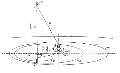
[0065] Reference is directed to Figure 7, which is a spatial view of the
general
case where the uncertainty region is not centered about the base station 8.
Let P 66 be
a plane parallel to the Earth tangential plane at the base-station S antenna
location but
not necessarily passing through it (typically, it will be below the base
station antenna).
Also, assume that the satellite 18 is above plane P 66 and that the base
station 8
antenna is also above plane P 66. The terminal unit 2 is located within plane
P 66 and
it is assumed that the terminal unit uncertainty region A, 68 or 70, is a
smooth
contiguous area on plane P 66. Since EIA IS-801 defines the uncertainty region
as an
ellipse, in order to make the aforesaid coplanar terminal unit location
assumption, A
must be restricted to a circle of radius R of at most 50km. This is consistent
with the
aforementioned 20 km assumption about CDMA `cell' service area dimensions.
[0066] The desired result is, again, to find the minimum and maximum values
of the function f (r) = IF - S-, - jr - b _j for any terminal unit 2 user
location within
CA 02425547 2007-04-03
74769-647
19
uncertainty region A 68 or 70. Let C (of coordinates Z) 69 be the intersection
of the
line 67 passing through the base station 8 antenna location and the satellite
18 location
with the plane P 66. Two postulates are then considered:
Case where C E A :
[0067] In this case, the function will take both its minimum and maximum
values on the boundary of the uncertainty area A 70. Since it is blown that
they are
on the boundary, the boundary of A 70 is sampled and the value of the function
f at each
location is taken. Let f,,,,,, and f,,,,,c be the minimum and maximum values
that f can take
among all the sample locations chosen. The search window center and size are
then
given by:
_ n f min + f max
PCenter - PBTS - Cf +
PSize = fmax - fmin
Case where C E A:
[0068] In this case, the function takes its maximum value at the base-station
8
location and its minimum value somewhere on the uncertainty area A 68
periphery.
Therefore fnax = f (E). Since it is known that f,,,,, is on the boundary of A
68, the
boundary is sampled and the value of the function f is computed at each
location
selected. Again, let f,n be the minimum value that f takes among all the
sample
locations chosen. The search window center and size are then given by:
PCenter - PBTS f
L
PSize max - mix
[0069] The number of sample points taken on the surface A will depend on
how smooth the uncertainty area is. The smoother the area the fewer the points
needed. In the case of an ellipse 20 sample points are enough. Obviously the
size
selected corresponds to the minimum acceptable guaranty that the terminal unit
is
CA 02425547 2003-04-10
WO 02/31526 PCT/US01/32014
going to be within the search window in a virtual noiseless case. When noise
is
present some margin can be added.
Second Scenario
[0070] Reference is directed to Figure 8, which is a spatial view of the
second
scenario. In this scenario, there is a more accurate estimation of the
terminal unit 2
clock reference. The variable i is defined as the estimate of the receiver
time bias
obtained from the network. Based on this estimate of the terminal unit 2 clock
bias,
the offset in code phase due to the terminal unit 2 clock error will be:
8c1ock = -f . The
terminal unit 2, base-station 8 and satellite 18 three-dimensional positions
are
respectively given by F, b and Y. The geometrical offset relative to base
station 8
causes the following code-phase offset: Sgeontetry = IT - sI - 1b - s' . Based
on these two
values, the best estimate of the pseudo-range measurement at the terminal unit
2
location is:
Puser = PBTS + clock + 15geometry = PETS + I r - S I - Ib - S t - Z
[0071] The term that varies based on the terminal unit 2 location is:
f (r) = IF - sI. The search window is then defined by the extreme values of
this
function for terminal unit 2 positions anywhere within the uncertainty area
72.
Finding the search window center and size is therefore a two-dimensional
function
(since the terminal unit 2 elevation is known within a very small, and
statistically
insignificant range) maximization/minimization problem.
[0072] In this scenario the function f (r) = Ir`- sI is obviously less complex
than in the first scenario. Because the satellite 18 distance is so great, the
following
CA 02425547 2003-04-10
WO 02/31526 PCT/US01/32014
21
simplification is reasonable: f (r) = IY - sI = (r - s) = is . Where IS = b _
s is the unit
vector running from the satellite 18 to the base station 8. Therefore, the
pseudo-range
interval is a projection of the uncertainty area 72 onto the unit vector going
from the
satellite 18 to the base station 8. In order to illustrate this, take the
simple case where
the uncertainty area 72 is circular of radius R, within a plane parallel to
the Earth 4
tangential plane at the base station 8 and with center 74 at the point with
coordinates
m \. The function f (7) is bounded by the following values:
Im - Y J - R = cos(V) < f (-T)<_ IN - Y J + R = cos(07) . The corresponding
search window
center and size are:
PC,,,,, PBTS + I i - S I- lb- - S I- Z
/"Size = 2R . cos(?g)
Third Scenario
[0073] Reference is directed to Figure 9, which is a spatial view of the third
scenario. In this scenario, the base station 8 has a more accurate estimation
of both
time (as in scenario II) and terminal unit 2 location. Define p = [x X z] 78
and z
respectively the estimate of the user position in the ECEF frame (Earth
Centered,
Earth Fixed) and the estimate of the receiver time bias both obtained
beforehand
(most likely from network measurements). In addition to these estimates, it is
possible based on information obtained beforehand concerning measurement
statistics
to obtain an estimated covariance matrix. One of the rows (and the same
column) in
the matrix corresponds to the time bias estimate. The matrix will be expressed
in a
specific frame but it is trivial to rotate it so as to bring the x axis to be
parallel to the
unit vector going from the base station 8 to the satellite 18. After this is
done, the
variance vc of the positioning error along the LOS direction to the satellite
G is
CA 02425547 2003-04-10
WO 02/31526 PCT/US01/32014
22
known. In addition to this, the covariance matrix provides the variance VT of
the time
bias estimate error T and the cross correlation KGT between T and G.
[0074] The terminal unit 2, base station 8 and satellite 18 positions are
respectively given by F, b and S-. Based on these definitions and assumptions,
the
offset in code phase due to the receiver clock bias and the position offset
are:
8clock = -f -T and 8geomet,y = I p - Y J - Ib - s` + G . Based on these two
values the best
estimate of the pseudo-range measurement at the terminal unit 2 location is:
Puser = PBTS + clock + geometry - N BTS _f -T + I17 - S I - Ib - S I + G
The term that varies with specific statistics is: f (G, T) = G -T .
[0075] The function f (G, T) = G -T is handled as a random variable with
mean 0 and variance:
E[f(G,T)]=E[(G-T)2J=E[G2]-2=E[G=T]+E[T2]=vG -2=KGT +VT.
[0076] The corresponding standard deviation is: or = jVG - 2 = KGT + VT .
Based on a trade-off between probability of miss and size of the search window
the
factor a is selected as the number of standard deviations that should be
included in
the search window. The final search window center and size are:
)"Center =PBTS +I p`-SI -Ib -SI -Z
/''Size =2. a. VG -2=KGT +VT
[0077] Thus, the present invention has been described herein with reference to
a particular embodiment for a particular application. Those having ordinary
skill in
the art and access to the present teachings will recognize additional
modifications,
CA 02425547 2007-04-03
74769-647
23
applications and embodiments within the scope thereof. For example, while the
present invention is described herein with respect to CDMA, those skilled in
the art
will appreciate that other technologies may be used. In addition, the
satellite may be
pseudo-lites or other mobile platforms operating in low orbit or high altitude
without
departing from the scope of the present teachings.
[0078] It is therefore intended by the appended claims to cover any and all
such applications, modifications and embodiments within the scope of the
present
invention.