Note: Descriptions are shown in the official language in which they were submitted.
CA 02539783 2013-01-31
1
Method and device for determining the actual position
of a geodetic instrument
The invention relates to a method for determining the
actual position of a geodetic instrument, a device for
carrying out this method, a geodetic instrument
comprising such a device and a computer program
product.
In many geodetic applications, methods and systems for
position determination of a geodetic instrument are
used, which methods and systems are based on the
propagation of signals which can be shadowed and thus
limited in their usability. Global
positioning
systems, such as, for example, GPS, GLONASS or the
European Galileo system under construction are an
example of such position-determining systems. These
systems are based on the reception of satellite signals
in a form as undisturbed as possible. In the immediate
vicinity of obstacles, the reception of the signal may
be limited or completely impossible owing to the
shadowing effect thereof, so that a position
determination is no longer possible by means of the
system. A
further example is the position
determination of a reflector-bearing instrument
comprising a theodolite or tacheometer. By means of a
direction and distance measurement with the tacheometer
to the geodetic instrument the position of the
instrument can also be determined when the position of
the tacheometer is known. A
precondition for the
measurement here is the visual link between the two
components. If
this link is interrupted, for example
CA 02539783 2013-01-31
2
by growth or buildings in the region of sight, the
position determination method fails.
Methods which are based on a determination of the
position of the instrument itself relative to objects
whose position is known are known for a position
determination of the actual position, i.e. of the
current location of the instrument, also in a dead
range shadowed in such a manner. An example of this is
the classical trilinear surveying method.
In many cases, a geodetic instrument has only a
capability for distance measurement, or a measurement
of angles cannot be carried out with the required
precision or speed. In these
cases, the position
determination must be carried out by distance
measurements alone. For this purpose, the distances to
a plurality of points having a known position are
measured, and the determination of the actual position
can be effected by known methods, as also used, for
example, in photogrammetry; correlation methods or
correlation calculations are an example of this. The
number of points required is dependent on the position
thereof and the intended accuracy of the measurement.
However, apart from particularly advantageous
configurations, as a rule at least 3 or 4 points are
required. If an
angle is additionally taken into
account, for example by additionally measuring the
angle relative to the horizontal, the number of points
can be reduced.
CA 02539783 2013-01-31
, .
3
In order also to be able to use positions in the dead
range for surveying by a purely distance-measuring
method, it is first necessary to survey, from known
locations, the reference points subsequently required
for referencing.
A surveying device suitable for this purpose is
described, for example, in European Patent EP 0 403 585
Bl.
The surveying device has a receiver for a
satellite position-measuring system and a preferably
electrooptical telemeter or telemeter based on the
ultrasonic principle. Both components are mounted on a
plumbing staff which can be precisely positioned with
its plumbing staff tip and has an inclinometer and a
display of the vertical alignment.
Optionally, a
sensor reacting to the earth's magnetic field may also
be present. By means of at least 2 measurements to a
point from 2 different known positions which are
determined, for example, by the
satellite
position-measuring system the position of this point
can now be determined even if it is within the dead
range.
Conversely, the position of such a surveying device in
the dead range can also be determined by measurements
to a plurality of known points in the trilinear
surveying method.
If surveying positions for the geodetic instrument
which are both in spaces detected by the positioning
system and in dead ranges are to be used in a survey,
it is necessary, before using the dead range, to survey
CA 02539783 2013-01-31
4
corresponding reference points for a subsequent
determination of the actual position in the dead range.
If it is intended to dispense with an explicit angle
measurement, as a rule the distances must be measured
at least for three to four points from at least three
to four known positions, in order to permit an
unambiguous position determination. The
number of
points actually required in each case is dependent on
the position of the known points and any possible
limitations for reducing ambiguity. In the
case of
three distance measurements to a point, a plane across
which the position to be determined can be reflected is
defined by the three known points. The
resulting
solution comprises two possible positions, of which,
however, one position can generally be ruled out for
plausibility reasons, for example because it would lie
below the earth's surface, or because of simple further
information, such as, for example, the distinction
between north and south, which can also be made by
means of a simple magnetic compass. An
unambiguous
determination with three known points is possible if
advantageous geometrical conditions are present. This
is the case, for example, if the position sought lies
on a connecting line between two known points.
Depending on the circumstances of a measurement, at
least between 9 and 16 distance measurements must
therefore be carried out, for which in each case a
correct assignment of measurement to reference point
and known position must be effected. Carrying out such
measurements manually therefore means a high handling
effort and error-producing complexity.
CA 02539783 2013-01-31
Moreover, in order to achieve sufficient accuracy of
the position determination, reference points suitable
because of their geometrical arrangement have to be
5 chosen. The
position change between the known
positions which is to be consciously implemented also
has an adverse effect on the measuring process.
Finally, the extension of the regions detected by the
positioning system and shadowed must be actively
observed with such methods of the prior art in order to
be able to carry out in good time a change of the
positioning method to be used.
An aspect of the present invention is to reduce the
number of reference points required for determining the
actual position in a shadowed region and/or of
measurements for determining the position of these
reference points.
The increase in the accuracy of the position in the
determination of an actual position in a shadowed
region is a further aspect of the present invention.
A further aspect is the simplification and shortening
of the measurements for determining reference points
and actual position.
A further aspect of the invention is to permit
automatic identification and surveying of the reference
points.
CA 02539783 2013-01-31
6
Finally, the automation of the position determination
and of the automated change between the respective
methods suitable for this purpose is a further aspect
of the present invention.
The invention relates to a method and a device for
determining the actual position of a geodetic
instrument. For this purpose, distance measurements to
at least two reference points in each case are carried
out by a device in a region in which shadowable signals
of a positioning system can be received, at at least
two positions. Linked
to these distances, image
information is additionally recorded by the device.
Said information may consist of complete images of a
detected region of vision or, for example, of partial
images or sections. The
measured distances are
coordinated with reference structures linked to the
image information or present therein. In the simplest
case, these reference structures may be points, but
also larger or more complex structures. Suitable
points are, for example, readily identifiable
transitions, edges or intersections of lines, such as,
for example, window corners or window crosses. The
term image information includes in particular the
relative arrangement for individual points. According
to the invention, these points are generally linked to
distance measurements to objects used as reference
structures, these distance measurements being
coordinated in each case with the physical pixels of a
receiver which represent the object or belong to its
copy on the receiver. A
logical coordination of
distance and reference point can then in turn be
CA 02539783 2013-01-31
7
derived from the mutual arrangement of the distance
measurements. Here,
image information is to be
understood as meaning in particular also the mutual
arrangement or orientation of distance measurements
which take place simultaneously to all pixels of a
detected region of vision. Thus,
an image no longer
necessarily consists of the recording of textures or
surfaces but may also consist exclusively of distance
measurements related to one another and in particular
geometrically arranged. Such range
imaging therefore
gives, for example, a two-dimension arrangement of
distance measurements and hence a sort of
three-dimensional image or a topography of the detected
field of view or measuring field. The
measurements
can, however, also be coordinated with a normal image
which includes texture. For
example, brightness and
distance can be recorded for each pixel so that
precisely these brightness values and distances are
available for each piece of image information, which
consists, for example, of the position of a physical
pixel on the receiver. However, the arrangement of a
distance measurement relative to other distance
measurements can also be effected so that it is also
possible to dispense with a knowledge of the absolute
position of a pixel on the receiver. As a result, it
is possible, for example, to dispense with a complete
evaluation of the region of view detected by the
receiver, so that higher processing speeds can be
realised, for example with subwindowing or subframing.
The distances can now be measured directly to the
reference structures or can also be made to
CA 02539783 2013-01-31
8
interpolation points, from which distance information
relating to the reference structures can then be
derived.
For recording images, CCD and CMOS cameras provide a
large number of suitable sensors which in the meantime,
in some versions, can additionally record distance
information for each pixel (range imaging) so that, for
example, the three-dimensional images described above
can also be derived. If such
sensors are used,
distance measurements to many points of the image can
be effected simultaneously. In principle, however, it
is also possible to use scanning solutions in which the
image content is surveyed sequentially with regard to
its distance, simultaneously with the recording of the
image information.
Alternatively, it is also possible, according to the
invention, to effect a manual distance measurement to
selected points in an image. Suitable
methods and
devices for manually controlled surveying of points in
a detected image are disclosed, for example, in EP 1
314 940 Al. This electronic display and control device
described therein permits the selection of points in an
image to which measurements can be carried out without
it being necessary to effect a movement of the optical
axis. By the
manual selection of points and the
sequential, optionally automatic surveying thereof,
distance and image information of the various points
are linked.
CA 02539783 2013-01-31
9
The actual spatial positions of the reference
structures can now be determined from the distance
measurements recorded from the at least two known
positions and linked to the respective image
information. Generally known methods of photogrammetry
and of image processing can be used for deriving this
information. In particular, the degrees of freedom can
be limited from step to step or from known position to
the next successive position. This
means that a
further or more accurate determination of the spatial
positions of the reference structure is made with each
known position from which a measurement is effected.
The number of required positions and number of recorded
parameters, as well as the intended accuracy of the
position determination, are correlated with one
another.
Linking of image information and distance
information offers a large number of advantages over
the sequential surveying of individual points. Because
the measurements are made simultaneously or at times
close to one another and are arranged as images,
coordination problems are avoided. In
addition, the
detection of the spatial arrangement or sequence of the
measurements provides additional information which can
be used for the subsequent determination of the actual
position.
In addition, by recording images divided into pixels,
it is possible to conclude the angle of a reference
structure relative to a reference point. If,
for
example, an image recording is always made with
horizontal alignment of the camera axis, the angle
relative to the horizontal can be derived from the
CA 02539783 2013-01-31
position of a pixel. Equally, the points can also be
described in terms of their position relative to one
another.
5 Since not all points of a detected image are required,
the number of reference structures can be limited to
easily and clearly recognisable image regions so that
even partial images or images changed by image
processing, for example by increasing the contrast, are
10 used or stored. Regarding the choice of a particularly
suitable partial region of the image which is
furthermore to be considered, CMOS sensors which permit
subwindowing or the definition of a special region of
interest in the image recording can advantageously be
used.
Known image processing and surveying methods exist for
identification of structures in various images and any
automatic surveying which may be effected. Thus,
a
method and a device for geodetic surveying of an object
with the aid of image processing are described, for
example, in EP 1 460 377 Al. Templates which can be
placed on the representational image can be used for
fixing the target point and automating a surveying
process. Furthermore, the derivation of precise angle
information from a representational image is permitted.
After the recording of the image and distance
information from the two known positions, the actual
position can also be determined in the dead range. For
this purpose, a recording and measurement is once again
carried out, in which a region of view which contains
CA 02539783 2013-01-31
11
at least two of the reference structures must be
covered. From a knowledge of the reference structures,
it is possible to conclude the actual position, for
example by a trilinear surveying method. For
this
purpose, the actual positions of the reference
structures must have been derived.
Alternatively, however, it is also possible to dispense
with a determination of these positions, by deriving
the actual position by means of a transformation from
the two known positions. The
actual position is
therefore linked not via the intermediate step of the
calculated positions of reference structures but to the
two known positions from which the measurements were
carried out. The
measurement of the reference
structures serves only for deriving the suitable
transformation matrices.
By means of the large number of recorded measurements,
ambiguities of the solutions can be eliminated and a
sufficient accuracy of the actual position can be
ensured.
One possibility for carrying out the method in a
completely automated manner using an embodiment of the
device according to the invention permits surveying in
regions which are accessible to the signals of the
positioning system or are shadowed, without paying
particular attention to the limit of these regions
during the measuring process. For this
purpose, the
device is formed in such a way that, during the
surveying process, its detection region is always
CA 02539783 2013-01-31
12
coarsely aligned with a clearly visible region. Images
of this region together with the measured distances are
recorded automatically and continuously. The
identification of the reference points in the region of
detection or in the images is effected automatically
and by means of image processing methods. The
continuous recordings carried out constantly during the
surveying pass through various points whose position is
determined by the positioning system or whose position
is in any case known, for example since said points are
previously measured points or trigonometrical points.
Provided that the signals of the positioning system are
detected to an extent sufficient for determining the
actual position, the positioning system is used for the
position determination. However,
if the reception
deteriorates or is completely interrupted the device
automatically switches to the method according to the
invention for referencing on the basis of reference
points. Here, a warning or an indication can also be
output to the user at the same time. This makes
it
possible to carry out surveys without taking into
account the limitations due to any shadowed signals.
Particularly in strongly transected regions it is
necessary to choose only two known starting points from
which the method then also permits measurements in dead
ranges, for example in street canyons.
In principle, the method according to the invention can
also be used in regions in which reception of signals
of a positioning system is possible. In this respect,
the use of the method is not limited to the use in dead
ranges.
CA 02539783 2013-01-31
13
In this context, the term "geodetic instrument" is
always to be understood generally as meaning a
measuring instrument or an instrument which is used in
association with geodetic measurements, such as, for
example, a plumbing staff, this serving for the
measurement or checking of data having a spatial
reference. In
particular, this relates to the
measurement of distance and/or direction or angles to a
reference point or measuring point. In
addition,
however, further devices, for example components for
image recording or for communication with other system
components, may be present and can be used for
supplementary measurements or data recordings.
In particular, such a geodetic instrument is to be
understood here as meaning theodolites and also
so-called total stations as tacheometers with
electronic angle measurement and electrooptical
telemeter. Equally, the invention is suitable for use
in specialised devices having a similar functionality,
for example in military aiming circles or in the
monitoring of industrial structures or processes; these
systems are herewith also covered by the term "geodetic
instrument".
The method according to the invention and a device
according to the invention are described in more detail
below, purely by way of example, with reference to
working examples shown schematically in the drawing.
Specifically,
CA 02539783 2013-01-31
14
Fig. 1 shows the schematic diagram of a surveying
task using a positioning system with
shadowable signals;
Fig. 2 shows an example of the formation of shadowed
regions with the use of a satellite-supported
positioning system;
Fig. 3 shows an example of the formation of shadowed
regions with the use of an Earth-supported
positioning system;
Fig. 4 shows the schematic diagram of the first step
of the method according to the invention with
the use of a satellite-supported positioning
system;
Fig. 5 shows the schematic diagram of the second
step of the method according to the invention
with the use of a satellite-supported
positioning system;
Fig. 6 shows the schematic diagram of the
determination of an actual position in a
shadowed region by the method according to
the invention in a first embodiment;
Fig. 7 shows the schematic diagram of the
determination of an actual position in a
shadowed region by the method according to
the invention in a second embodiment;
CA 02539783 2013-01-31
Fig. 8 shows
the schematic diagram of the recording
of reference structures and the distances
coordinated with them;
5 Fig. 9 shows the
schematic diagram of the derivation
of image information from the recording of
reference structures;
Fig. 10 shows
an example for explaining the use of
10 image
information for eliminating ambiguities
in the position determination and
Fig. 11 shows
the schematic diagram of an embodiment
of the device according to the invention and
15 of a
geodetic instrument according to the
invention.
Fig. 1 shows a typical surveying task with the use of a
positioning system. The
aim of the surveying is to
determine the position of various points on an object
2c which is arranged in a building group together with
a hall 2a and a building 2b.
Surveying is effected
using a geodetic instrument 1 which has the components
necessary for the respective surveying task. The
actual position of this instrument 1 which represents
the current position to be determined in each case for
the purpose of surveying, can be determined on the
basis of the signals of a positioning system, this
being assumed here purely by way of example to be a
satellite-supported system. The actual position can be
derived from the signals of the satellites 3, which
CA 02539783 2013-01-31
16
signals are received by a satellite receiver of the
instrument 1 and propagate substantially linearly.
Fig. 2 schematically shows the situation in the
immediate vicinity of the object to be surveyed. If it
is necessary for surveying purposes to position the
instrument 1 in the immediate vicinity of the hall 2a,
the line of sight to the satellites 3 required for the
determination of the actual position is interrupted by
the height of the hall 2a. The hall
2a therefore
defines a dead range T in which the reception of
signals of the satellites 3 is limited or prevented.
The surveying of the object can no longer be effected
from this dead range T, since the actual position can
no longer be determined with the aid of the positioning
system.
However, the building 2b is clearly visible
from this dead range T.
A similar situation is shown in Fig. 3 for another
variant of a positioning system. In a surveying task
identical to Fig. 2, an instrument 1' whose position is
determined with the aid of a total station 4 as a total
positioning system is now used. For this purpose, the
instrument carries a reflector instead of a satellite
receiver, so that direction and distance to the
reflector is measured from the total station 4
positioned on a known point. From
this data, the
actual position of the instrument 1' can be determined.
In a manner similar to the diagram of Fig. 2, the line
of sight between total station 4 and instrument 1',
which is required for the measurement, is also limited
CA 02539783 2013-01-31
17
or interrupted by the hall 2a in certain regions, so
that a dead range T' likewise forms.
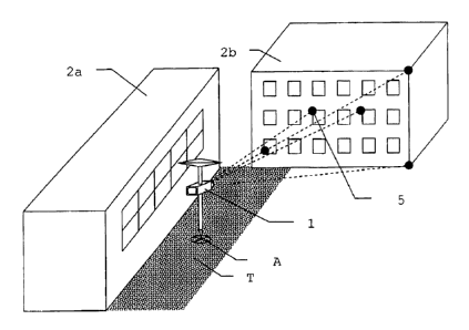
Fig. 4 schematically shows the first step of an
exemplary method according to the invention for
determining the actual position. For a
first known
position P1, at least two reference structures 5 on the
building 2b also detectable from the dead range T are
detected by means of the instrument 1 and a distance to
these reference structures 5 is measured. In this
example, points are chosen purely by way of example as
reference structures 5, but, in particular by means of
image processing methods, it is also possible to choose
extensive structures and to compare them with one
another in the further steps. Reference
structures
located in the dead range T itself can also be chosen,
i.e. a measurement could also be effected according to
the invention to a reference structure or a point on
the hall 2a. The distance measurement is effected with
the use of the recording of an image in which the
distances are coordinated with the reference structures
5. In this example, the first known position P1 can be
determined by the signals of satellites 3 since this
first known position P1 is present outside the dead
range T produced by the hall 2a. After the recording
of the reference structures 5 with the coordinated
image information and distances, the instrument 1 is
moved to a second known position P2.
As shown in Fig. 5, a second recording of the reference
structures 5 present on the building 2b, together with
the coordinated image information and distances, is
CA 02539783 2013-01-31
18
made from the second known position P2. In
this
example, the second known position P2 can also be
determined by the signals of the satellites 3 of a
positioning system.
Alternatively, however the first
known position P1 and/or the second known position P2
can also be determined by other methods or their
position may also be known. In principle, one or both
of the positions can therefore also be located in the
dead range T but the position must then also be capable
of being determined without a positioning system or
must be known. As in the case of all movements shown,
the detection of the reference structures 5 can be
permitted or facilitated by automatic target tracking.
Fig. 6 schematically shows the determination of an
actual position A with the aid of a first embodiment of
the method according to the invention. The instrument
1 is now present in the dead range T produced by the
hall 2a. From this dead range T the building 2b and at
least a part of the reference structures 5 can be
detected, so that the actual position A can be
determined by means of these reference structures 5.
In the first embodiment of the method according to the
invention, this determination is based on the knowledge
of the actual position of the reference structures 5,
these being calculated from the image information and
distances which were recorded during the steps shown in
Fig. 4 and Fig. 5. For deriving the actual position A,
the image information and distance of the reference
structures 5 are recorded in a manner similar to the
first two steps so that the actual position can be
determined from the knowledge of these data and the
CA 02539783 2013-01-31
19
known position of the reference structures 5, for
example by means of a trilinear surveying method. In
addition to the consideration of isolated reference
structures 5 present in the image, an evaluation of the
various pieces of image information can also be
effected by extensive matching by image processing, for
example by suitable matching methods, a larger number
of points being taken into account simultaneously.
Fig. 7 schematically explains the determination of an
actual position A with the aid of a second embodiment
of the method according to the invention. The
instrument 1 is present in the dead range T produced by
the hall 2a, from which dead range the building 2b and
at least a part of the reference structures 5 can be
detected. In
this second embodiment of the method
according to the invention, the determination of the
actual position A is effected by means of a
transformation of the first known position P1 and
second known position P2 shown in Fig. 4 and Fig. 5 to
the actual position A. The
link between these
positions is made via the reference structures 5, for
which transformation matrices are derived in each case.
Such transformation methods are, for example, known or
derivable from photogrammetry. Thus, in
this second
embodiment of the method according to the invention no
real positions for the reference structures 5 are
calculated, so that errors occurring in the calculation
can be avoided.
Fig. 8 shows, purely by way of example, the recording
of reference structures and distances linked thereto.
CA 02539783 2013-01-31
By means of a component for image recording, for
example a CCD or CMOS camera, preferably having range
imaging functionality, the building 2b is captured in
an image 6 and this is optionally stored. The image 6
5 consists of a relatively large number of pixels, it
being possible for the reference structures 5 to be
coordinated in their dimensions in each case with only
one pixel or with a plurality of pixels.
Distance
measurements are carried out to these reference
10 structures, it being possible for both reference
structures 5 and the measuring points of the distance
measurement to be determined manually or in an
automated manner. Known image processing methods, such
as, for example, template matching and/or neuronal
15 networks, are available for automated selection and
identification of suitable structures. In the case of
relatively large structures, distance measurements can
be carried out both to each individual pixel and to a
single pixel coordinated with the reference structure
20 5, from which the distance information for further
pixels can then be extrapolated. In the example shown,
distance measurements can be carried out to all five
detected points as reference structures 5, it being
possible for the distance to be coordinated equally
with the respective mean pixel (pixel corresponding to
the centre of gravity) or with all pixels covered by
the respective point.
Fig. 9 shows, purely by way of example the derivation
of image information from the recording of reference
structures. The
example shown here serves merely to
explain the principle, since, in embodiments realised,
CA 02539783 2013-01-31
21
predominantly more highly developed methods of image
processing can advantageously be used, which, however,
does not rule out purely manual handling. In addition
to the point- or structure-specific distance
information, it is possible to derive from the
recording further image information which relates, for
example, to the position in the image or the relative
arrangement of the reference structures 5 to one
another. For
example, the position of the point
located furthest left can be determined by horizontal
and vertical counting of the pixels. From
the
horizontal number X and the vertical number Y of
pixels, the position in the image as well as relative
to a reference point can be determined, which reference
point may be the lower left corner of the detected
image section here.
Equally, the positions of the
points relative to one another can also be surveyed, as
illustrated by the differences 1X1, AY1 and AY2 of
pixels between individual points. From
the
differences, it is also possible to derive angles on
the basis of the existing distance measurements to the
points. Thus, in addition to the distance measurement,
information about the arrangement of the reference
structures relative to one another and relative to a
reference point can also be simultaneously captured,
which information can be compared as image information
with the image information of further recordings. It
is not necessary for a method according to the
invention to record or store complete images. What is
relevant is a recording of image information or image
features which permit a comparison with further
recordings. For
this purpose, for example, special
CA 02539783 2013-01-31
,
22
regions of the capture area (regions of interest) can
be selected or the representation of the captured area
can be processed so that structures are emphasised and
are easier to recognise. In
this respect, image
information is not always in coincidence with the
recording of a full image but can in each case contain
more or less information.
Fig. 10 shows a greatly simplified, two-dimensional
example for explaining the use of image information for
eliminating ambiguities in the position determination.
Two reference structures 5' and 5" whose position is
known are available for deriving the actual position.
The distance to both reference structures 5' and 5" is
measured so that the actual position must lie on a
circle at the respective distance around the position
of the respective reference structure 5' or 5".
Simultaneous fulfilment of this condition is present
only at the two points of intersection of the circles.
Without further information it cannot now be decided
which of the two actual positions A' or A" resulting
therefrom is correct. From the recording of an image,
it is possible to derive, as image information, the
fact that, in all measurements, the second reference
structure 5" was always located to the right of the
first reference structure 5', so that the possible
actual position A" is ruled out. This
greatly
simplified and purely qualitative example is intended
to explain how image information can be used in a
fundamental manner for reducing ambiguities. Pure
disorganised capture of distance measurements to
various points does not include the necessary
CA 02539783 2013-01-31
23
information relating to the arrangement.
Moreover,
quantitative image information, such as, for example,
the angles of the reference structures to one another
can also be derived from the recordings.
The schematic diagram of a possible embodiment of the
device according to the invention and of a geodetic
instrument 1 according to the invention is shown in
Fig. 11. The
geodetic instrument 1 has a plumbing
staff 7 which can be accurately positioned by means of
a tip. A GPS
receiver 8 for a satellite-supported
positioning system as a unit for position determination
and a measuring unit 9 comprising a device for
determining an actual position of the geodetic
instrument 1 are present on the plumbing staff 7. This
device has an image recording unit 10, an image and/or
image information memory 13, a telemeter 12 and a data
processing unit 14. The region captured by the image
recording unit 10 is indicated to the user on a
touch-sensitive screen 11, it being possible for the
user to control the surveying process by means of this
screen. If the
intensity of the signal of the
positioning system falls below a predetermined
threshold, the loss of signal is indicated to the user
by means of an alarm. Optionally, the transition to an
automated procedure for the method according to the
invention can be triggered by the data processing unit
14.
moreover, the device may optionally have an
inclinometer 15 and/or a direction meter 16.
The figures show the steps of the method, buildings and
instruments used purely schematically. In
particular
CA 02539783 2013-01-31
24
no size relationships or details of the image
processing or surveying of the reference structures are
evident from the diagrams. The points shown purely by
way of example as reference structures also represent
more complicated structures which can be handled with
regard to surveying and evaluation by image processing
means.