Note: Descriptions are shown in the official language in which they were submitted.
CA 02620448 2008-02-08
PATENT APPLICATION
ATTORNEY DOCKET NO. 19.0452
DETERMINING WELLBORE POSITION WITHIN SUBSURFACE EARTH
STRUCTURES AND UPDATING MODELS OF SUCH STRUCTURES USING
AZIMUTHAL FORMATION MEASUREMENTS
Background of the Invention
Field of the Invention
[0001] The invention relates generally to the field of determining position of
a wellbore
within subsurface Earth formations. More specifically, the invention relates
to methods
for using azimuthally dependent formation property measurements of such
formations to
more precisely locate the position of the wellbore and to refine models of the
Earth's
subsurface structure.
Background Art
[0002] Wellbores are drilled through subsurface Earth formations to extract
useful
materials such as oil and gas that are present in certain subsurface
formations. Wellbore
drilling is typically performed in a manner to optimize the amount of oil and
gas bearing
formation that is in hydraulic communication with a wellbore. Such
optimization
includes drilling wellbores that are highly inclined, even horizontal, over
relatively large
distances (e.g., several kilometers) in order to cause the wellbore to be
positioned within
the oil and/or gas bearing formation over a great lateral distance. Such
positioning
increases the effective drainage radius of the wellbore within the producing
formation.
[0003] In order to optimize such wellbore drilling, it is known in the art to
produce a
model of the structure of the Earth's subsurface formations. Such models may
be
initially generated using techniques that do not use data from within the
subsurface
formations, such as seismic surveying and electromagnetic surveying. Such
surveys are
interpreted to produce an initial estimate or model of the spatial
distribution of the
subsurface formations, including those that may contain oil and/or gas.
1
CA 02620448 2008-02-08
PATENT APPLICATION
ATTORNEY DOCKET NO. 19.0452
[0004] As one or more wellbores are drilled through the formations that have
been
modeled using the above seismic and/or electromagnetic surveying techniques,
the model
may be adjusted or updated to reflect information obtained during or after the
drilling of
such wellbore(s). Such information is generally obtained in the form of "well
logs," such
well logs being a record with respect to position along the wellbore of
various physical
parameters. Such parameters may include, for example, electrical conductivity
(resistivity), acoustic velocity, density, neutron porosity and natural gamma
radiation and
formation fluid pressure among others. Such well logs may be made during the
drilling
of the wellbore, using so called "logging while drilling" (LWD) measurements,
or
afterward, using well logging instruments conveyed along the wellbore using
armored
electrical cable or other known conveyance technique. A model may also be
initially
generated based on well logs alone.
[0005] In order to adjust or update the initial model of the Earth's
subsurface structure in
a useful manner based on such well log data, it is necessary to know with
reasonable
precision the geodetic position of the wellbore at every point along its
length, and the
precise position along the wellbore of the particular well logging instrument
whose
measurements are used to adjust the model. The position along the wellbore is
referred to
as the "measured depth" and may be reasonably precisely determined using
techniques
well known in the art.
[0006] Determining the geodetic position of the wellbore at any point along
its length is
typically performed using directional sensors disposed in the well logging
instrument.
Such directional sensors may include magnetometers to determine wellbore
direction
with respect to the Earth's magnetic poles and accelerometers to determine the
inclination
of the wellbore from vertical (gravity). It is also known in the art to use
inertial
navigation devices to determine geodetic direction of the wellbore.
Irrespective of the
type of directional measurement instrument being used, limits on their
accuracy and
precision result in some degree of uncertainty as to the absolute geodetic
position of the
wellbore. There are corresponding limits to the accuracy and precision of the
initial
models made from seismic and/or electromagnetic surveys. As a result, in some
wellbore
drilling operations, wherein it is desirable to maintain the wellbore
trajectory within a
2
CA 02620448 2010-05-12
79350-258
particular formation within the Earth's subsurface, the degree of uncertainty
as to the
relative positions of the wellbore and the subsurface formations may limit the
ability of
the wellbore operator to so maintain the wellbore trajectory.
[0007] More recently, apparatus and methods have been developed that provide
formation property measurements that are directionally (azimuthally)
sensitive, and can
provide estimates of the distance from the well logging instrument to one or
more
formation boundaries (wherein a mineral composition and/or fluid content of
the
formation changes). See, for example, U.S. Patent Application Publication No.
2005/0140373 filed by Li et al. and assigned to the assignee of the present
invention.
[0008] There continues to be a need to more precisely determine the position
.of a
wellbore within structures in the Earth's subsurface and to be able to
navigate wellbores
during drilling to maintain such position along a desired trajectory with
respect to
subsurface formations.
Summary of the Invention
[0009] One aspect of the invention is a method for determining structure in
the Earth's
subsurface. A method according to this aspect of the invention includes
generating an
initial model of the structure. The initial model includes at least one layer
boundary. A
wellbore is drilled along a selected trajectory through the Earth's subsurface
in a volume
represented by the initial model. At least one formation parameter is measured
azimuthally along the wellbore. A distance from the wellbore is determined at
selected
positions therealong to the at least one layer boundary using the azimuthal
parameter
measurements. The initial model is adjusted using the determined distances.
3'
CA 02620448 2010-04-01
79350-258
Another aspect of the invention is a method for determining structure
in the Earth's subsurface, comprising: generating an initial model of the
structure
based on a well log, the initial model including at least one upper layer
boundary
and at least one lower layer boundary; drilling a wellbore along a selected
trajectory through the Earth's subsurface in a volume represented by the
initial
model; azimuthally measuring at least one formation parameter along the
wellbore; determining a distance from the wellbore at selected positions
therealong to the at least one upper layer boundary and to the at least one
lower
layer boundary using the azimuthal formation parameter measurements
independent of wellbore uncertainty and relative to the initial model; and
adjusting
the initial model using the determined distances.
[0010] A system for modeling a subsurface structure of the Earth according
to another aspect of the invention includes an instrument for measuring a
formation parameter azimuthally along a wellbore drilled through a volume of
the
Earth's subsurface represented by an initial model. A processor is in signal
communication with the instrument. The processor is configured to determine a
distance from the wellbore to at least one formation boundary in the volume
from
azimuthal measurements made by the
3a
CA 02620448 2008-02-08
PATENT APPLICATION
ATTORNEY DOCKET NO. 19.0452
instrument. The processor is configured to adjust the initial model using the
determined
distance.
[0011] Other aspects and advantages of the invention will be apparent from the
following
description and the appended claims.
Brief Description of the Drawings
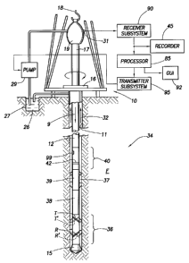
[0012] FIG. 1 is an elevational view of a conventional rotary drilling string
in which the
present invention may be used.
[0013] FIG. 2 is a schematic representation of a basic directional measurement
logging
tool having symmetrical transmitter and receiver antenna pairs.
[0014] FIG. 3A is a schematic representation of an example directional
measurement
logging tool having a TRR configuration that is insensitive to anisotropy at
any dip angle.
[0015] FIG. 3B shows plots of the directional propagation response for a three-
layer
formation using a logging tool according to FIG. 3A.
[0016] FIG. 4 shows a cross section of a well path superimposed on an initial
model and
an updated model based on azimuthally sensitive resistivity measurements.
[0017] FIG. 5 is a flow chart of one example of a method for determining
structure in the
Earth's subsurface.
Detailed Description
[0018] Methods and systems according to the various aspects of the invention
include
making measurements along a wellbore of at least one formation parameter using
an
instrument that is azimuthally sensitive. The azimuthally sensitive formation
parameter
measurements are made both along the wellbore and in a plurality of azimuthal
directions
around the wellbore such that a distance can be determined from the wellbore
(or the
instrument) to a formation boundary. Two specific examples of azimuthal
parameter
measurements that can be used to determine distance to a formation boundary
described
in more detail below are resistivity of the formation and acoustic travel
time. As a matter
4
CA 02620448 2008-02-08
PATENT APPLICATION
ATTORNEY DOCKET NO. 19.0452
of principle, the particular formation parameter being measured only needs to
have
contrast at formation layer boundaries, and be measurable at a sufficient
lateral distance
from the wellbore to as to be able to effectively determine the position of
the wellbore
with respect to such layer boundaries without having the wellbore penetrate
such
boundaries. Examples in this description that include a specific parameter,
such as
resistivity, should not be considered limiting.
[0019] An apparatus and technique for measuring formation resistivity as
described in
U.S. Patent Application Publication No. 2005/0140373 filed by Li et al. may be
used in
some examples of implementing a method and system according to the present
invention.
The apparatus and technique described in the `373 publication are in part
described below
with reference to FIGS. 1-3B in order to explain one example of how to
determine
position of a wellbore with respect to subsurface formation boundaries. In
some
examples, such determination may be used to more precisely define the wellbore
trajectory within the Earth's subsurface structure than may be possible using
directional
measurements alone. In some examples, such determination may be used to update
or
refine a model of the structure of the Earth's subsurface.
[0020] FIG. 1 illustrates a conventional drilling rig and drill string. A land-
based
platform and derrick assembly 10 are positioned over a wellbore 11 penetrating
a
subsurface Earth formation F. In the illustrated embodiment, the wellbore 11
is formed
by rotary drilling in a manner that is well known. It will be readily
appreciated by those
skilled in the art, however, that the present invention also finds application
in directional
drilling applications as well as rotary drilling, and is not limited to land-
based rigs.
[0021] A drill string 12 is suspended within the wellbore 11 and includes a
drill bit 15 at
its lower end. The drill string 12 is rotated by a rotary table 16, energized
by means not
shown, which engages a kelly 17 at the upper end of the drill string. The
drill string 12 is
suspended from a hook 18, attached to a traveling block (also not shown),
through the
kelly 17 and a rotary swivel 19 which permits rotation of the drill string
relative to the
hook. Drilling fluid ("mud") 26 is stored in a tank or pit 27 formed at the
well site. A
pump 29 moves the drilling fluid 26 to the interior of the drill string 12 via
a port in the
CA 02620448 2008-02-08
PATENT APPLICATION
ATTORNEY DOCKET NO. 19.0452
swivel 19, inducing the drilling fluid to flow downwardly through the drill
string 12 as
indicated by arrow 9. The drilling fluid exits the drill string 12 via ports
in the drill bit 15,
and then circulates upwardly through the annular space between the outside of
the drill
string and the wall of the wellbore, as indicated by arrows 32. In this
manner, the drilling
fluid cools and lubricates the drill bit 15 and carries formation cuttings up
to the surface
as it is returned to the pit 27 for recirculation. It will be appreciated by
those skilled in
the art that the drill string 12 may alternatively be rotated by a top drive
(not shown) or
similar rig-suspended device. The lower portion of the drill string 12 may
also be rotated
by an hydraulic motor (not shown) operated by flow of the drilling fluid 26
and coupled
within the drill string 12. Such motors are known in the art as "mud motors."
Accordingly, the device used to rotate the drill string shown in FIG. 1 is not
intended to
limit the scope of the invention.
[0022] The drill string 12 further includes a bottom hole assembly, generally
shown at
34, near the drill bit 15 (in other words, within several drill collar lengths
from the drill
bit). The bottom hole assembly 34 includes instruments for measuring,
processing, and
storing measurement information, as well as communicating with equipment at
the
Earth's surface. The bottom hole assembly 34 may include, among other things,
a
measuring apparatus 36 for determining and communicating the resistivity of
the
formation F surrounding the wellbore 11. The measuring apparatus 36, also
known as a
resistivity tool, includes a first pair of transmitting/receiving antennas T,
R, as well as a
second pair of transmitting/receiving antennas T', R'. The second pair of
antennas T', R'
are symmetric with respect to the first pair of antennas T, R, as is described
in greater
detail below. The measuring apparatus 36 further includes a controller to
control the
acquisition of data, as is known in the art.
[0023] The bottom hole assembly ("BHA") 34 in the present example can further
include
instruments housed within drill collars 38, 39 for performing various other
measurement
functions, such as measurement of the natural gamma ray radiation, density
(gamma ray
or neutron), neutron capture cross section, transverse and/or longitudinal
nuclear
magnetic relaxation properties and fluid pressure in the pore spaces of the
formation F.
Some devices for measuring fluid pressure may make time indexed measurements
such
6
CA 02620448 2008-02-08
PATENT APPLICATION
ATTORNEY DOCKET NO. 19.0452
that inferences of permeability of the formation F may be made. At least some
of the
drill collars may include stabilizers 37, as is well known in the art.
[0024] A surface/local communications subassembly 40 is also included in the
BHA 34,
just above the drill collar 39. The subassembly 40 includes a toroidal antenna
42 used for
local communication with the measuring apparatus 36 (although other known
local-
communication means may be used), and a known type of acoustic telemetry
system that
communicates with a similar system (not shown) at the Earth's surface via
signals
induced in the drilling fluid or mud by modulating the flow thereof. Thus, the
telemetry
system in the subassembly 40 includes an acoustic transmitter that generates
an acoustic
signal in the drilling fluid ("mud pulse") that is representative of measured
downhole
parameters. The local communication subassembly 40 may also include an
electric
and/or optical fiber telemetry device to transmit signals at relatively high
bandwidth over
a so-called "wired" drill pipe. Such pipe includes at least one insulated
electrical
conductor and/or optical fiber along the entire length of the drill string 12
such that
signals may be transmitted to the Earth's surface thereover. See, e.g., U.S.
Patent No.
7,017,667 issued to Hall et al. and incorporated herein by reference.
[0025] The generated acoustical signal in the drilling fluid is received at
the surface by
transducers represented by reference numeral 31. The transducers 31, for
example,
piezoelectric transducers, convert the received acoustical signals to
electronic signals.
The output of the transducers 31 is coupled to an uphole receiving subsystem
90, which
demodulates the transmitted signals. The output of the receiving subsystem 90
is then
coupled to a computer processor 85 and a recorder 45. The processor 85 may be
used to
determine the formation resistivity profile (among other things) on a "real
time" basis
while the wellbore is being drilled or "tripped" (moving the drill string into
and/or out of
the wellbore) or subsequently by accessing recorded data from a recorder 45
associated
with the subassembly 40. The computer processor 85 may be coupled to a monitor
92 that
employs a graphical user interface ("GUI") through which the measured downhole
parameters and particular results derived therefrom (e.g., resistivity
profiles) are
graphically presented to a user. Alternatively, if the signals are transmitted
over
7
CA 02620448 2008-02-08
PATENT APPLICATION
ATTORNEY DOCKET NO. 19.0452
electrical and/or optical conductors, as described above, electrical and/or
optical coupling
may be made to the receiving subsystem 90 for decoding such signals.
[0026] An uphole transmitting system 95 is also provided for receiving
commands input
by the user (e.g., using the GUI in the monitor 92), and may be configured to
selectively
interrupt the operation of the pump 29 in a manner that is detectable by
transducers 99 in
the subassembly 40. In this manner, there is two-way communication between the
subassembly 40 and the uphole equipment. A suitable subassembly 40 is
described in
greater detail in U.S. Pat. Nos. 5,235,285 and 5,517,464, both of which are
assigned to
the assignee of the present invention. Those skilled in the art will
appreciate that
alternative acoustic techniques, as well as other telemetry means (e.g.,
electromechanical,
electromagnetic), can be used for communication between the subassembly 40 and
the
Earth's surface. As was explained above with respect to electrical and/or
optical
telemetry, commands may also be sent from the processor 85 to the local
subassembly 40
in the wellbore using such electrical and/or optical telemetry.
[0027] In the present example, two types of coil antennas can be used to make
resistivity
measurements with directional (azimuthal) sensitivity. One type provides
directional
sensitivity by having the antenna either offset, e.g., from the center of a
logging
instrument's longitudinal axis, or partially covered. Directional measurements
can also
be made with an antenna configured so that its magnetic moment is not aligned
with the
longitudinal axis of the instrument. The present example may use the latter
type of
directionally-sensitive antenna.
[0028] FIG. 2 schematically illustrates a basic resistivity tool 36 for
directional
electromagnetic (EM) wave measurement. The tool 36 includes a transmitter
antenna T
that induces an EM wave of a selected frequency f and a receiver antenna R
that is a
selected distance L away from the transmitter antenna T. Also shown is the
symmetric
pair (T', R') described above with reference to FIG. I and which may be in
accordance
with the description in U.S. patent application Publication No. 20003/0085707
fled by
Minerbo et al. and assigned to the assignee of the present invention. For
clarity and
simplification, the description that follows will be limited to the
transmitter antenna T
8
CA 02620448 2008-02-08
PATENT APPLICATION
ATTORNEY DOCKET NO. 19.0452
and the receiver antenna R, although it is generally applicable to the
symmetric antenna
pair, T' and R'. It should be noted that although the moment of the two
symmetrical
antenna pairs are on the same plane in FIG. 2, this is not required. As will
be clear in the
subsequent description, signals from two pairs that have their moment in
different planes
can still be added together to achieve equivalent results if the extracted
coefficients or
directional phase-shift or attenuation are used in a symmetrization operation.
[0029] In operation, the receiver antenna R will have a voltage VRT induced
therein by
the EM wave from the transmitter antenna T and its secondary currents produced
in the
formation penetrated by the borehole containing the logging tool 36. Both
antennas T
and R are fixed on the tool 36 and thus rotate with the tool 36. The antenna
orientations
may be described as angles OT for the transmitter antenna T, and OR for the
receiver
antenna R. The azimuthal variation of the induced voltage in the receiver R as
the tool 36
rotates can then be expressed in terms of the coupling of Cartesian components
of the
magnetic dipoles.
[0030] One particular aspect of the measurements of phase-shift and
attenuation is that
they are suited for "while drilling" measurements, for which detailed
characterization of
thermal electronics drift under downhole conditions is difficult to perform.
The
directional phase-shift and attenuation measurements defined herein have the
benefit of a
traditional borehole-compensated propagation resistivity tool, namely that the
transmitter
and receiver antenna characteristic and the drift of the receiver electronics
are all
canceled out of the measurement.
[0031] The above analyses can be extended straightforwardly to the traditional
TRR type
of measurements, as described in the Minerbo et al. publication referred to
above. One
skilled in the art can easily show that this procedure produces essentially
the same
response as indicated above, but with twice the signal when the spacing
between the
receiver pair is much smaller comparing with the TR spacing. The directional
signals
from the two receivers simply add.
[0032] FIG. 3A shows a TRR configuration that is insensitive to anisotropy
(change in
apparent resistivity of a formation with respect to the direction of
measurement) at any
9
CA 02620448 2008-02-08
PATENT APPLICATION
ATTORNEY DOCKET NO. 19.0452
dip angle, and FIG. 3B shows responses according to this configuration.
Transmitter
antenna Ti is energized and the phase shift and attenuation from the receiver
antennas
R11, R12 is measured. Then, transmitter antenna T2 is energized and the phase
shift and
attenuation from the receiver antennas R21, R22 is measured. The tool reading
corresponds to the differences between these two sets of measurements. Since
the
individual measurements are identical in a homogeneous medium at any angle and
with
any anisotropy, the tool readings are zero in a homogenous medium at any dip.
[0033] The measurement responses in a three-layer anisotropic formation are
shown in
FIG. 3B. The tool reading is zero far from the boundary at any dip, and there
is little
sensitivity to anisotropy close to the boundary. Separation in responses
results from the
fact that EM propagation responses are not completely symmetric if the
transmitter and
receiver location are interchanged. It should be observed that attenuation
responses are
practically overlapping for different dip if all antennas are in the same
medium. The
phase shift measurements are also overlapping, although responses are double-
valued in
the conductive bed (1 S/m). The manner in which distances to layer boundaries
in the
Earth's subsurface from the azimuthally sensitive resistivity measurements is
well
described in the `373 publication and need not be presented herein in any more
detail.
[0034] The above description is intended to provide an example of how
distances to
boundaries of subsurface Earth formations from a well logging instrument may
be
determined. Such determined distances are used in some examples to adjust
and/or
update a model of the structure of the Earth's subsurface.
[0035] FIG. 4 is an expanded scale view of a plane section of an in initial
model and an
updated model to illustrate the principle of a method according to the
invention. An
initial model of the Earth's subsurface structure may be generated that
includes the
spatial distribution (shown in 2 dimensions in FIG. 4) of various mineral
compositions of
Earth formations, and of petrophysical properties of such Earth formations,
such as their
fractional volume of pore space (porosity), the fluid content in such pore
spaces (water
saturation), fluid pressure in the pore spaces, and estimates of permeability,
among other
properties. Alternatively, such models may be of spatial distribution of
petrophysical
CA 02620448 2008-02-08
PATENT APPLICATION
ATTORNEY DOCKET NO. 19.0452
measurement parameters, such as resistivity and natural gamma radiation. The
parameters used in the initial model are not intended to limit the scope of
the invention.
[00361 Such subsurface models may be initially generated using, for example,
seismic
and/or electromagnetic survey information, as explained above, among other
techniques,
where no subsurface information is available. The initial model may from time
to time
be updated or refined to reflect data obtained from one or more wellbores
drilled through
the Earth's subsurface within the volume represented by the initial model.
Such
updating, as is known in the art, may include well log data such as
resistivity, acoustic
velocity, neutron porosity, natural gamma radiation, density and fluid
pressures, among
other data. The data used to refine or update the model may also include
actual samples
of the subsurface Earth formations (cores). So-called "checkshot" surveys may
also be
obtained from within such wellbores in order to measure seismic travel time
from the
surface to selected depths in the wellbore, so that the seismic survey data
may be
corrected for the effects of varying formation seismic velocity through the
subsurface. If
no seismic data or electromagnetic survey data are available, the initial
model may be
made entirely from subsurface information. It is also known in the art to
construct initial
models entirely from well log data and formation sample (core) data.
Accordingly, the
source of data used to generate the initial model is not a limit on the scope
of the
invention.
[00371 Because well log data are typically recorded with respect to what is
inferred to be
the depth in the Earth, such well log data may preferably be obtained from
wellbores
drilled such that any uncertainty in the actual geodetic position of the
wellbore within the
Earth's subsurface, resulting from limitations of accuracy and precision of
wellbore
directional measuring instruments, will have relatively little effect on the
model. Such
wellbores are those in which the wellbore intersects the various subsurface
formations
relatively close to perpendicularly to the attitude of the formation. In
formations that are
relatively horizontally disposed, therefore, such wells would be substantially
vertical. It
is to be clearly understood that the invention is not limited in scope to
using well log data
obtained from wellbores drilled perpendicularly through the subsurface
formations. As a
practical matter, however, the invention may have particular application in
the placement
11
CA 02620448 2008-02-08
PATENT APPLICATION
ATTORNEY DOCKET NO. 19.0452
of wellbores drilled substantially parallel to the attitude of one or more
subsurface
formations, or in using data obtained from such wellbores to update models of
the Earth's
subsurface over a wide geodetic area. As will be appreciated by those skilled
in the art,
to a large extent, subsurface formations of interest to producers of oil and
gas are largely
modeled as substantially horizontally disposed layers of rock, wherein
wellbores drilled
parallel to the layering thereof are substantially horizontally disposed.
[0038] An important aspect of such subsurface models, whether updated by well
log data
or not, is an expected spatial distribution of one or more formations that are
intended to
be penetrated by a wellbore in a direction essentially parallel to their
attitudes. Those
skilled in the art will appreciate that one example of such spatial
distribution is a
subsurface hydrocarbon reservoir formation. Such reservoir may have an
oil/water
contact therein. An objective of drilling a wellbore through such reservoirs
may be to
maintain the well path to the greatest extent possible within an oil layer
disposed above
the oil/water contact. In FIG. 4, an initial model (which may be updated by
well log data
as explained above) may include a spatial distribution of a reservoir upper
limit 54A.
Such upper limit may represent the boundary between the reservoir bearing
formation
and an overlying "cap rock" (not shown) consisting of relatively impermeable
formation(s). Spatial distribution of a lower limit of the reservoir from the
initial model
is shown at 54C. A fluid contact is shown at 54B. Such fluid contact 54B may
be an
oil/water contact, a gas/oil contact, or a gas/water contact, for example. A
wellbore
trajectory through the subsurface formations projected onto the initial model
is shown in
FIG. 4 at 52.
[0039] During or after drilling of the wellbore, azimuthal resistivity
measurements may
be made as explained above with reference to FIGS. 1-3B, and at selected
positions along
the wellbore, a distance to an upper formation boundary, shown at dI, and a
distance to a
lower formation boundary, shown at d2, may be determined as explained above
using
such azimuthal resistivity measurements. Using the determined distances, dI,
d2, an
updated or adjusted position of the upper limit and lower limit may be
determined, as
shown generally at 50A for the upper limit and at 50B for the lower limit. The
updated
12
CA 02620448 2008-02-08
PATENT APPLICATION
ATTORNEY DOCKET NO. 19.0452
positions of the upper 50A and lower 50B limits may then be used to update the
initial
model of the Earth's subsurface.
[0040] An example method according to the invention will now be explained with
reference to the flow chart in FIG. 5. At 60, an initial model of the Earth's
subsurface is
generated. Such initial model, as explained above, may be made using seismic
and/or
electromagnetic surveying, and may be updated or refined using well log data
and/or
formation sample data if such data are available. At 62, in a wellbore drilled
at high
incident angle to the attitude of formations of interest, azimuthally
sensitive
measurements of a formations parameter such as resistivity, are made. Such
measurements may be made during drilling the wellbore or thereafter. At 64,
using such
measurements, at various positions along the wellbore, a distance may be
determined
from the wellbore to one or more formation boundaries. Such boundaries may
include
fluid contacts and/or formation composition changes, as explained above.
[0041] The distances determined at 64 may be used, at 66, to update or refine
the initial
model. The initial model may be adjusted to reflect the above determined
distances from
the wellbore.
[0042] At 68, other well log measurements may be made, either
contemporaneously with
the azimuthally sensitive resistivity measurements or afterward. Because the
position of
the wellbore with respect to the formation boundaries will be better
determined as a result
of performing the distance determination at 64, such other well log
measurements will
more precisely associated, as shown at 70, with particular subsurface
formations
estimated from the initial model. At 72, the updated model determined at 66
may be
refined using the additional or subsequent well log data. The initial model,
updated or
adjusted models and any other well log or other data may be stored in the
processor (85
in FIG. 1) and/or displayed using the GUI monitor (92 in FIG. 1).
[0043] In some examples, the determined geodetic position of the wellbore
along its
trajectory may be refined, at 74, and the refined position information may be
used in
conjunction with the boundary distance determination at 64 to update the model
of the
Earth's subsurface. As explained above, the wellbore trajectory (position at
each point
13
CA 02620448 2008-02-08
PATENT APPLICATION
ATTORNEY DOCKET NO. 19.0452
along its length) may be determined during drilling using directional sensors
disposed in
one or more of the components of the drill string. During drilling or
afterward, the
measurements made by the directional sensors may be supplemented by such data
as
checkshot survey determined seismic travel time. Checkshot surveys may be
performed
during drilling or afterward. See, for example, U.S. Patent No. 5,555,220
issued to Minto
and U.S. Patent Application Publication No. 2005/0041526 filed by Esmersoy et
al. and
assigned to the assignee of the present invention. A checkshot survey may
enable more
precise determination of the position of the wellbore with respect to a
seismic section.
By more precise determination of the wellbore position with respect to the
seismic
section, and by using the determined distances to the layer boundaries, it may
be possible
to refine the model with respect to the seismic section. If the seismic
section suggests,
for example, that there is relatively little lateral velocity variation in the
Earth's
subsurface within the model volume, then a seismic time to depth record made
in a near-
vertical wellbore within the model volume may be used to calibrate the
checkshot survey
with respect to depth. Thus, the model may be refined to more precisely
position the
layer boundaries with respect to depth in the subsurface.
[0044] As previously stated, other formation parameters may be measured
azimuthally to
determine the distance from the wellbore to the formation boundary. U.S.
Patent No.
7,035,165 issued to Tang, incorporated herein by reference, describes using
acoustic
measurements to make such distance determinations. As described in the Tang
`165
patent, such measurements and determinations may be made as follows. A
plurality of
multicomponent acoustic measurements indicative of a formation parameter of
interest
(typically acoustic velocity or slowness) is obtained at a plurality of
wellbore positions
(depths) and for a plurality of source-receiver spacings on the logging
instrument. An
orientation sensor on the instrument, which can be a magnetometer, is used for
obtaining
an orientation measurement indicative of an orientation of the logging
instrument. The
multicomponent acoustic measurements are mathematically transformed (rotated)
to a
fixed coordinate system such as a geodetic system defined with respect to
magnetic or
geographic north, using the orientation measurement, giving rotated
multicomponent
measurements. The rotated multicomponent measurements are processed for
obtaining
14
CA 02620448 2008-02-08
PATENT APPLICATION
ATTORNEY DOCKET NO. 19.0452
the parameter of interest. In one example, the parameter of interest includes
an azimuth
and relative dip of the bed boundary. In one example, the multicomponent
measurements
are made with a cross-dipole acoustic sensor. In another example, the
multicomponent
measurements are hybrid data, i.e., obtained from either a monopole source
into a cross-
dipole receiver pair or a cross-dipole source into a monopole receiver.
[0045] When measurements are made at a plurality of depths, the processing can
provide
a migrated image of bed boundaries in the earth formation. In one example,
compressional waves produced by a dipole source are used. Prior to migration,
certain
pre-processing may be used, such as high pass filtering, first break
determination,
frequency-wavenumber (f - k) filtering, dip median filtering, and, selective
gating of the
data in time windows. On the migrated sections, the relative dip may be
obtained by
fitting a line to a linear trend on one of said plurality of migrated image
data sections. The
azimuth is determined by an inversion of the migrated image data sections, the
inversion
based at least in part on minimizing a cost function over an image area of
interest.
[0046] A system for modeling subsurface Earth structures may include formation
parameter measuring and data processing components such as shown in and
explained
above with reference to FIG. 1. Such a system includes an instrument for
azimuthally
measuring at least one formation parameter. One example of a parameter may be
resistivity, as explained above. Another example of a parameter may be
acoustic
velocity, also as explained above. The system may include a processor for
storing an
initial model of the subsurface Earth structure. The processor may be
configured to
process the azimuthal parameter measurements to determine distance to a
formation
boundary at selected positions along a wellbore. The processor may be
configured to
adjust the initial model using the distance measurements. The processor may be
configured to adjust the model using at least one additional petrophysical
parameter
measured in the wellbore. The processor may be operatively coupled to a
display for
producing a visible image of the initial and/or adjusted model. In one
example, the
system includes a so-called "wired" drill string having therein an electrical
conductor
and/or optical fiber that enables measurements from the azimuthal measuring
instrument
CA 02620448 2008-02-08
PATENT APPLICATION
ATTORNEY DOCKET NO. 19.0452
to be communicated to the processor substantially in real time, such that the
model may
be adjusted substantially in real time.
[0047] Methods and systems according to the invention may result in more
precise
models of spatial distribution of subsurface formations and their fluid
content. More
precise models may improve the drilling of subsequent wellbores to optimize
drainage of
subsurface reservoirs, by reducing placement of wellbores into unsuitable
formations.
[0048] While the invention has been described with respect to a limited number
of
embodiments, those skilled in the art, having benefit of this disclosure, will
appreciate
that other embodiments can be devised which do not depart from the scope of
the
invention as disclosed herein. Accordingly, the scope of the invention should
be limited
only by the attached claims.
16