Note: Descriptions are shown in the official language in which they were submitted.
CA 02641986 2008-08-08
WO 2007/095224 PCT/US2007/003769
Systems and Methods for Spatial Thumbnails and Companion
Maps for Media Objects
Cross-Reference to Related Applications
[0001] This application claims the benefit of U.S. Provisional Patent
Application No.
60/772,088, filed February 10, 2006 and entitled "Thumbnails," the entire
contents of
which are incorporated herein by reference.
Technical Field
[0002] This application relates to media objects, and more particularly to
displaying
information about media objects.
Background
100031 Media objects are physical or electronic recordings or representations
of
information, thoughts, or_emotions. People have created and used media objects
for
thousands of years. Recently, technological advancements have enabled a great
proliferation of media objects and an increase in exchange of media objects
amongst
people. This exchange of media objects is frequently facilitated by summaries
of media
objects. For example, a movie may be recorded in digital form and sold over
the lnternet
to people who wish to view the movie. Typically, the prospective movie buyer
examines
many possible movie choices and selects only a small number. This selection
process
determines the commercial success of the moviemakers. To increase the number
of
people who choose their movie, the moviemakers typically create "trailers" or
short
sequences of excerpted footage from the film to tempt people to get the entire
movie.
These trailers condense the much larger media object into a new media object
that
summarizes the larger media object. The creation of the summary can be as much
an art
form as the creation of the original media object.
(0004] The movie trailer concept has analogs in many forms of media objects.
Without the concept of a summary, search and selection of media objects would
be
1
CA 02641986 2008-08-08
WO 2007/095224 PCT/US2007/003769
greatly impaired. For example, the back cover or dust jacket of a book often
describes the
story line, exciting attributes about the author, and praise from other people
for the book's
value. As another example, search engines generate short textual excerpts from
the web
pages and other documents that match a user's search request. These excerpts
summarize
the contents of the document. Image and video search engines similarly
endeavor to
produce summaries of the content of the media objects sought by their users.
100051 Often, a summary is implemented in the same kind of medium as the media
object that it describes, e.g. the text of a book is often summarized by text
on the dust
jacket, and a miniature clay figurine may summarize the gestalt of a large
stone sculpture.
However, this is not always true of summaries, e.g. a talk show host might
verbally
summarize the story line of a book, which is a textual media object. A
recording of the
talk show host would be a media object that summarizes the book.
100061 A defining attribute of a summary is that it contains less than all the
content of
the media object. However, summaries sometimes introduce new information that
is not
present in the original media object. For example, a talk show host might
render opinions
of a book, or a movie trailer might arrange its excerpts in an order that
communicates a
particular idea that is not obviously present in the movie itself.
100071 Generally, a summary is clearly associated with the media object that
it
summarizes. This association is often achieved by presenting the summary
visually
adjacent to a means of accessing the media object that it summarizes. For
example, a
summary generated by a search engine is usually presented near a hyperlink to
the media
object that the search engine is providing in response to a user's search
query. As
another example, the summary in a dust jacket is physically bound around the
book it
summarizes.
[0008] With the advent of automated analysis techniques that glean information
from
digital media using computer algorithms, some summaries are partially or
totally
generated without the aide of a human. A now-famous task in the engineering
discipline
of natural language processing is "automatic summary generation." Automatic
summary
generation is usually thought of as a text analysis process, however the
resampling and
2
CA 02641986 2008-08-08
WO 2007/095224 PCT/US2007/003769
rescaling of an image to generate a smaller version of an image is another
type of
automatic summarization. Such summary images are often called "image
thumbnails"
because in comparison to the larger image, the summary image could be as small
as the
nail material on the end of a human's thumb. While possibly hyperbolic, this
gives a
sense of the scaling down and condensing of information involved in
summarization.
[0009] Summaries also exist in cartography. Making a more general map of a
place
on Earth from information provided by a detailed map has been a central
activity of
cartographers for centuries. The act of creating a map at lower scale than an
original
more detailed map requires careful judgment about which features to remove and
which
to include. Typically, this is called "cartographic generalization" in the
sense that the
detailed specific features of a high-scale map must be made more general and
less
specific for display at a lower scale. Frequently, large-format, high-scale
maps are
presented with a a small-format, low-scale summary map or "overview" map
showing the
position of the large-format, high-scale map within a larger geographic area
that maybe
more easily recognized by viewers than the smaller physical area described by
the large-
format, higher scale map. These overview maps are usually much smaller format
than the
main map for which they provide an overview. These maps offer both a summary
and
more information by showing surrounding areas of the world. Such overview maps
are
an example of a summary that is the same general type of media object as the
media
object that it summarizes.
[0010] Geographic maps have been used in conjunction with other media objects
for
hundreds of years. For example, a map showing the positions of events or other
geographic features can be presented along with text describing the events or
locations.
Historians or journalists describing a time period or set of issues in a place
often make
such narrative maps by annotating a map information, such as text and images,
relating to
locations within the map.
[0011] With the advent of computers, digital media objects have taken on many
new
forms.
3
CA 02641986 2008-08-08
WO 2007/095224 PCT/US2007/003769
Summary of the Invention
100121 The present invention provides a new type of summary that presents a
user
with new information about a digital media object, in a medium that can differ
from that
of the media object that it summarizes. We call this new type of summary a
"spatial
thumbnail." It is a "thumbnail" in the sense that it gives either a literal or
mental image
that is like an "image thumbnail" of a larger image. It is "spatial" in the
sense that it
depicts location-related content or spatial relationships conveyed in or
related to the
media object that it summarizes.
100131 One example of a spatial thumbnail is a literal image of a map with
visual
indicators showing the positions of locations referenced in a document along
with a piece
of text excerpted from the document. For specificity, we call this a "spatial
thumbnail
image for a text document" because they have a literal image and are
associated with a
text document. The detailed description describes systems and methods for
generating
and using these specific types of spatial thumbnails and also several other
types of spatial
thumbnails. In general, a spatial thumbnail can be thought of as a media
object that
summarizes another media object's location-related content.
100141 Under one aspect, a. computer-implemented method of displaying
information
about a media object, the media object being associated with location-related
content
corresponding to a location, includes receiving a request to display a
representation of the
media object; in response to the request, obtaining a summary of the media
object; in
response to the request, obtaining a spatial thumbnail of the media object,
the spatial
thumbnail including an image of a spatial domain encompassing the location;
and
simultaneously displaying both the summary of the media object and the spatial
thumbnail on a visual display.
100151 One or more embodiments include one or more of the following features.
The
spatial thumbnail further includes a visual indicator indicating the location
within the
image of the domain. The visual indicator represents a subset of the location-
related
content. The visual indicator includes a marker icon or arrow. Selecting a
type of visual
indicator based on a type of location reference expressed in the location-
related content.
4
CA 02641986 2008-08-08
WO 2007/095224 PCT/US2007/003769
The image includes at least one of a two-dimensional image, a three-
dimensional image,
an animated image, a computer-generated hologram, and a sculpture. The spatial
domain
includes one of a geographic domain, a physical and non-geographic domain, and
a
fictional domain. Displaying the summary of the media object includes
displaying at
least one of a fragment of the media object and an image of the media object.
Obtaining
the spatial thumbnail of the media object includes one of obtaining the
spatial thumbnail
from a repository and generating the spatial thumbnail, wherein generating the
spatial
thumbnail includes obtaining the location-related content of the media object
and
obtaining the image of the spatial domain encompassing the location. Receiving
the
request to display the representation of the media object includes receiving
user input
referencing the media object. The location-related content represents at least
one of a
geographical reference and a spatial relationship within the media object. The
location-
related content is generated by an automated geoparsing engine. The location-
related
content expresses a subset of geospatial references within the media object,
the subset of
geospatial references being selected by the automated geoparsing engine. The
media
object includes one of a digital document, living organism, paper document,
text
document, rock, video, email message, web page, slide show presentation,
spread sheet,
equation rendering, music, or book. The summary of the book includes at least
one of a
sub-media object excerpted from the book, a review of the book, an image of a
page of
the book, and an image from the book. The spatial thumbnail includes a marker
representing a spatial reference within the at least one sub-media object
excerpted from
the book. Also displaying a reference to the media object. The reference
includes at least
one of a hyperlink to the media object and a bibliographic reference to the
media object.
Also obtaining and displaying a plurality of spatial thumbnails for the media
object, at
least one spatial thumbnail representing different location-related content
than at least one
other spatial thumbnail. Also automatically generating the location-related
content
associated with the media object by performing the steps of identifying a
spatial reference
within the media object; associating a location with the identified spatial
reference, the
location being represented by a set of coordinates of a selected coordinate
system; and
encoding the set of coordinates in the location-related content.
CA 02641986 2008-08-08
WO 2007/095224 PCT/US2007/003769
[0016] Under another aspect, an interface program stored on a computer-
readable
medium for causing a computer system with a display device to display
information about
a media object, the media object being associated with location-related
content
corresponding to a location, causes the computer system to perform the
functions of
receiving a request to display a representation of the media object; in
response to the
request, obtaining a summary of the media object; in response to the request,
obtaining a
spatial thumbnail of the media object, the spatial thumbnail including an
image of a
spatial domain encompassing the location; and simultaneously displaying both
the
summary of the media object and the spatial thumbnail on a visual display.
[0017] Some embodimenti include a parsing engine capable of generating the
location-related content for the media object, the parsing engine including
instructions for
performing the following functions: identifying a spatial reference within the
media
object; associating a location with the identified spatial reference, the
location being
represented by a coordinate of a selected coordinate system; and encoding the
coordinates
in the location-related content.
100181 Under another aspect, a computer-implemented method of displaying
information about search results representing media objects, wherein at least
one media
object is associated with location-related content corresponding to a
location, includes:
receiving a query from the user; transmitting the query to a search engine;
receiving
search results from the search engine based on the query, each search result
representing a
media object; obtaining a spatial thumbnail for a search result representing a
media object
that is associated with location-related content corresponding to a location,
the spatial
thumbnail including an image of a spatial domain encompassing the location;
and
simultaneously displaying both the search results and the obtained spatial
thumbnail on a
visual display.
100191 One or more embodiments include one or more of the following features.
At
least some of the search results represent digital media objects stored in a
document
repository. At least some of the search results represent digital media
objects accessible
via the World Wide Web. Also displaying a summary of the represented media
object.
6
CA 02641986 2008-08-08
WO 2007/095224 PCT/US2007/003769
Displaying the summary includes displaying at least one of a fragment of the
represented
media object and an image of the represented media object. The query from the
user
includes one of a free-text query, a free-text query with other query
constraints, a
selection from a list of options, and navigating through a sequence of links.
The spatial
thumbnail further includes a visual indicator indicating the location within
the image of
the domain. The visual indicator represents a subset of the location-related
content. The
visual indicator includes a marker icon or arrow. Selecting a type of visual
indicator
based on a type of location reference expressed in the location-related
content. The
represented media object includes one of a digital document, living organism,
paper
document, text document, rock, video, email message, web page, slide show
presentation,
spread sheet, equation rendering, music, or book. The spatial domain includes
one of a
geographic domain, a physical and non-geographic domain, and a fictional
domain. The
spatial domain encompasses location-related content from multiple media
objects
represented by the search results. The image includes at least one of a two-
dimensional
image, a three-dimensional image, an animated image, a computer-generated
hologram,
and a sculpture. Obtaining the spatial thumbnail of the represented media
object includes
one of obtaining the spatial thumbnail from a repository and generating the
spatial
thumbnail, wherein generating the spatial thumbnail includes obtaining the
location-
related content of the represented media object and obtaining the image of the
spatial
domain encompassing the location. The location-related content includes at
least one of a
geographical reference and a spatial relationship within the represented media
object.
The location-related content is generated by an automated geoparsing engine.
The
location-related content expresses a subset of geospatial refererences within
the
represented media object, the subset of geospatial references being selected
by the
automated geoparsing engine. The search results include at least one of a
hyperlink and a
bibliographic reference to the represented media object. Also automatically
generating
the location-related content associated with the represented media object by
performing
the steps of: identifying a spatial reference within the represented media
object;
associating a location with the identified spatial reference, the location
being represented
by a set of coordinates of a selected coordinate system; and encoding the set
of
coordinates in the location-related content.
7
CA 02641986 2008-08-08
WO 2007/095224 PCT/US2007/003769
[0020] Under another aspect, an interface program stored on a computer-
readable
medium for causing a computer system with a display device to display
information about
search results representing media objects, wherein at least some of the media
objects are
associated with location-related content corresponding to locations, causes
the computer
system to perform the functions of: receiving a query from the user;
transmitting the
query to a search engine; receiving search results from the search engine
based on the
query, each search result representing a media object; obtaining a spatial
thumbnail for a
search result representing a media object that is associated with location-
related content
corresponding to a location, the spatial thumbnail including an image of a
spatial domain
encompassing the location; and simultaneously displaying both the search
results and the
obtained spatial thumbnails on a visual display.
Definitions
100211 For clarity, we define several terms of art:
[0022] A "media object" is any physical or electronic object that can be
interpreted as
containing information, thoughts, or emotions. Thus, a media object is a broad
class of
things, including such diverse objects as digital documents, living organisms,
paper
documents, text documents, rocks, videos, email messages, web pages, slide
show
presentations, spreadsheets, renderings of equations, and music.
[0023] A "digital media object" is a media object constructed from binary
electronic
signals or similar computing-machine oriented signals. Frequently, media
objects can be
stored in digital form, and this digital form can be replicated and
transmitted to different
computer systems many separate times.
[0024] A "document" is a media object containing information composed by
humans
for the purpose of transmission or archiving for other humans.
100251 A "digital document" is a document that is a digital media object, such
as a
file stored in a file system or web server or digital document repository.
8
CA 02641986 2008-08-08
WO 2007/095224 PCT/US2007/003769
100261 A "text document" is a document containing character symbols that
humans
can interpret as signifying meaning. A "digital text document" is a text
document that is
also a digital document. Typically, digital text documents contain character
symbols in
standardized character sets that many computer systems can interpret and
render visually
to users. Digital text documents may also contain other pieces of information
besides
text, such as images, graphs, numbers, binary data, and other signals. Some
digital
documents contain images of text, and a digital representation of the text may
be
separated from the digital document containing the images of text.
[0027] A "summary" is a media object that contains information about some
other
media object. By definition, a summary does not contain all of the information
of the
other media object, and it can contain additional information that is not
obviously present
in the other media object.
[0028] An "integrated summary" is a set of summaries about the same media
object.
For example, a web site about a book typically has several summaries organized
in
different ways and in different mediums, although they are all about the same
book. An
integrated summary can include both sub-media objects excerpted from the media
object
summarized by the integrated summary, and also summary media objects.
100291 To "summarize" is to provide information in the fonn of a media object
that is
a selection of less than all of the information in a second media object
possibly with the
addition of information not contained in the second media object. A summary
may
simply be one or more excerpts of a subset of the media object itself. For
example, a text
search engine often generates textual summaries by combining a set of
excerpted text
from a document. A summary may be one or more sub-strings of a text document
connected together into a human-readable string with ellipses and visual
highlighting
added to assist users reading the summary. For example, a query for "cars"
might cause
the search engine to provide a search result listing containing a list item
with the textual
summary "... highway accidents often involve <b>cars</b> that ... dangerous
pileups
involving more than 20 <b>cars</b>...." In this example, the original media
object
contained the strings "highway accidents often involve cars that" and
"dangerous pileups
9
CA 02641986 2008-08-08
WO 2007/095224 PCT/US2007/003769
involving more than 20 cars", and the summary creation process added the
strings "..."
and "<b>" and "</b>" to make it easier for users to read the concatenated
strings. These
substrings from a document and represented to a user are an example of a
"fragment" of a
media object.
100301 A "sub-media object" is a media object that is part of a second media
object.
For example, a chapter in a book is a sub-media object of the book, and a
paragraph in
that chapter is a sub-media object of the chapter. A pixel in a digital image
is a sub-
media object of the digital image. A sub-media object is any fragment of a
larger media
object. For example, a fragment of a document might be an image of a portion
of the
document, such is commonly done with digital scans of paper documents. A
fragment of
a text document might be a string of symbols contained in the text document
and
represented to a user. Since digital media objects can be replicated ad
infinitum, a sub-
media object of a digital media object can accurately reproduce any portion of
the original
media object without necessarily becoming a sub-summary.
[0031] A "sub-summary" is summary of a sub-media object. A summary may simply
be a set of one or more sub-media objects excerpted from the original media
object. The
word "sub-summary" is defined here for clarity: a summary of a sub-media
object is just
as much a summary as other types of summaries, however in relation to a
"containing
summary" about a larger fragment of the original work, a sub-summary describes
a
smaller part than the containing summary that summarizes the larger fragment.
[0032] A "metric space" is a mathematical conceptual entity defined as
follows: a
metric space is a set of elements possibly infinite in number and a function
that maps any
two elements to the real numbers with the following properties. A metric on a
set X is a
function (called the distance function or simply distance)
d:X x X-R
[0033] (where R is the set of real numbers). For all x, y, z in X, this
function is
required to satisfy the following conditions:
CA 02641986 2008-08-08
WO 2007/095224 PCT/US2007/003769
1. d(x, y) 0 (non-negativity)
2. d(x, y) = 0 if and only if x = y (identity of indiscernibles)
3. d(x, y) = d(y, x) (symmetry)
4. d(x, z) < d(x, y) + d(y, z) (subadditivity / triangle inequality).
[0034] A "vector space" is a mathematical conceptual entity with the following
properties: Let F be a field (such as the real numbers or complex numbers),
whose
elements will be called scalars. A vector space over the field F is a set V
together with
two binary operations:
vector addition: V X V - V denoted v + w, where v, w E V, and
scalar multiplication: F X V - V denoted a v, where a E F and v E V,
100351 satisfying the axioms below. Four require vector addition to be an
Abelian
group, and two are distributive laws.
1. Vector addition is associative: For all u, v, w E V, we have u+(v + w) _
(u+v)+w.
2. Vector addition is commutative: For all v, w E V, we have v + w = w +
V.
3. Vector addition has an identity element: There exists an element 0 E V,
called the zero vector, such that v + 0 = v for all vG V.
4. Vector addition has an inverse element: For all v E V, there exists an
element w E V, called the additive inverse of v, such that v + w = 0.
5. Distributivity holds for scalar multiplication over vector addition: For
all
a E F and v, w E V, we have a (v + w) = a v + a w.
11
CA 02641986 2008-08-08
WO 2007/095224 PCT/US2007/003769
6. Distributivity holds for scalar multiplication over field addition: For all
a,
b E Fandv E V, we have (a + b) v = a v + b v.
7. Scalar multiplication is compatible with multiplication in the field of
scalars: For all a, b E F and v E V, we have a (b v) = (ab) v.
8. Scalar multiplication has an identity element: For all v E V, we have I v
= v, where 1 denotes the multiplicative identity in F.
100361 Formally, these are the axioms for a module, so a vector space may be
concisely described as a module over a field.
100371 A "metric vector space" is a mathematical conceptual entity with the
properties of both a vector space and a metric space.
100381 The "dimension" of a vector space is the number of vectors in the
equivalence
class of basis vectors that minimally span the vector space.
100391 A "line segment" is a geometric entity in a metric space defined by two
entities in the metric space. These two entities are refered to as the "ends"
of the line
segment. The line segment is the two ends plus the concept of a shortest path
connecting
them, where the path length is determined by the metric on the metric space.
100401 A "domain" is an arbitrary subset of a metric space. Examples of
domains
include a line segment in a metric space, a polygon in a metric vector space,
and a non-
connected set of points and polygons in a metric vector space.
100411 A "sub-domain" is a domain which is a subset of another domain. For
example, if one is considering a domain that is a polygon, then an example of
a sub-
domain of that domain is a line segment or subset of line segments selected
from the set
of line segments that make up the polygon.
[00421 A "polyline" is an ordered set of entities in a metric space. Each
adjacent pair
of entities in the list is said to be "connected" by a line segment.
12
CA 02641986 2008-08-08
WO 2007/095224 PCT/US2007/003769
[0043) A "polygon" is a polyline with the additional property that it
implicitly
includes a line segment between the last element in the list and first element
in the list.
100441 A "polyhedron" is a set of polygons with some of the line segments
inherent in
the underlying polylines are associated with line segments from other polygons
in the set.
A "closed" polyhedron is a polyhedron in a metric vector space and every line
segment is
associated with a sufficient number of other line segments in the set that one
can identify
an interior domain and an exterior domain such that any line segment
connecting an
element of the interior domain to an element of the exterior domain is
guaranteed to
intersect a polygon in the set.
100451 A "spatial domain" is a domain in a metric vector space.
[0046] A "coordinate system" is any means of referring to locations within a
spatial
domain. For example, a so-called Cartesian coordinate system on a real-valued
metric
vector space is a tuple of real numbers measuring distances along a chosen set
of basis
vectors that span the space. Many examples of coordinate systems exist.
"Unprojected
latitude-longitude" coordinates on a planet, like Earth, are an example of two-
dimensional
spherical coordinates on a sphere embedded in three-dimensional space. A
"datum" is a
set of reference points from which distances are measured in a specified
coordinate
system. For example, the World Grid System 1984 (WGS84) is commonly used
because
the Global Position System (GPS) uses WGS84 as the defining datum for the
coordinates
that it provides. For coordinate systems used to describe geographic domains,
one often
speaks of "projected" coordinate systems, which are coordinates that can be
related to
unprojected latitude-longitude via mathematical functions and procedures
called
"projection functions." Other types of coordinate systems use grids to divide
a particular
domain into subdomains, e.g. the Military Grid Reference System (MGRS) divides
the
Earth into subdomains labeled with letters and numbers. Natural language
references to
places are a coordinate system in the general sense that people often
recognize a phrase
like "Cambridge" as meaning a place, but there may be many such places. Such
ambiguity is typically not tolerated in the design of coordinate systems, so
an important
13
CA 02641986 2008-08-08
WO 2007/095224 PCT/US2007/003769
part of constructing location-related content is coping with such ambiguity,
either by
removing it or describing it or simply stating that it exists.
100471 A "physical domain" is a spatial domain that has a one-to-one and onto
association with locations in the physical world in which people could exist.
For
example, a physical domain could be a subset of points within a vector space
that
describes the positions of objects in a building. An example of a spatial
domain that is
not a physical domain is a subset of points within a vector space that
describes the
positions of genes along a strand of DNA that is frequently observed in a
particular
species. Such an abstract spatial domain can be described by a map image using
a
distance metric that counts the DNA base pairs between the genes. An abstract
space,
humans could not exist in this space, so it is not a physical domain.
100481 A "geographic domain" is a physical domain associated with the planet
Earth.
For example, a map image of the London subway system depicts a geographic
domain,
and a CAD diagram of wall outlets in a building on Earth is a geographic
domain.
Traditional geographic map images, such as those drawn by Magellan depict
geographic
domains.
100491 A "location" is a spatial domain. Spatial domains can contain other
spatial
domains. A spatial domain*that contains a second spatial domain can be said to
encompass the second spatial domain. Since some spatial domains are large or
not
precisely defined, any degree of overlap between the encompassing spatial
domain and
the encompassed location is considered "encompassing." Since a spatial domain
is a set
of elements from a metric vector space, the word "encompassing" means that the
logical
intersection of the sets of elements represented by the two spatial domains in
question is
itself a non-empty set of elements. Often, "encompassing" means that all of
the elements
in the second spatial domain are also elements in the encompassing domain. For
example, a polygon describing the city of Cambridge is a location in the
spatial domain
typically used to represent the state of Massachusetts. Similarly, a three-
dimensional
polyhedron describing a building in Cambridge is a location in'the spatial
domain defined
14
CA 02641986 2008-08-08
WO 2007/095224 PCT/US2007/003769
by the polygon of Cambridge. The word "location" is a common parlance synonym
for a
"spatial domain."
100501 A `location reference" is a sub-media object of a document that a human
can
interpret as referring to a location. For example, a sub-string of a document
may be
"Cambridge, Massachusetts," which a human can interpret as referring to an
entity with
representative coordinates longitude-latitude coordinates (-71.1061, 42.375).
100511 A "geospatial reference" is a location reference to a location within a
geographic domain.
100521 "Location-related content" is information that can be interpreted as
identifying or referring to a location within a spatial domain. Location-
related content
can be associated with a media object in many ways. For example, location-
related
content may be contained inside the media object itself as location
references, such as
names of places, explicit latitude-longitude coordinates, identification
numbers of objects
or facilities or buildings. For another example, location-related content may
be associated
with a media object by a system that associates a reference to a media object
with
location-related content that is separate from the media object itself. Such a
system might
be a database containing a table with a URL field and a latitude-longitude
field in a table.
To obtain location-related content associated with a media object, a person or
computer
program might pass the media object to a geoparsing engine to extract location-
related
content contained inside the media object, or it might utilize a system that
maintains
associations between references to media objects and location-related content.
The fact
that a creator of a media object once lived in a particular place is a piece
of location-
related content associated with the media object. Other examples of such
auxiliary
location-related content are the locations of physical copies of the media
object and
locations of people interested in the media object.
100531 A "sub-media object that is not a location-related content" is a sub-
media
object that is not a location reference. For example, a fragment of a text
document that
says "Eat great pizza in" is not location-related content even though the
subsequent string
may be a location reference.
CA 02641986 2008-08-08
WO 2007/095224 PCT/US2007/003769
100541 A "spatial relationship" is information that can be interpreted as
identifying or
referring to a geometric arrangement, ordering, or other pattern associated
with a set of
locations. For example, "the aliens traveled from Qidmore Downs to Estheral
Hill,"
describes a spatial relationship that organizes the location references
"Qidmore Downs"
and "Estheral Hill" into an ordering.
100551 A "reference to a media object" is a means of identifying a media
object
without necessarily providing the media object itself. For example, a URL is a
reference
to a media object. For another example, media object title, author, and other
bibliographic information that permits unique identification of the media
object is a
reference to that media object.
100561 An "image" is a media object composed of a two-dimensional or three-
dimensional array of pixels that a human can visually observe. An image is a
multi-
dimensional representation of information. The information could come from a
great
variety of sources and may describe a wide range of phenomena. Pixels may be
black/white, various shades of gray, or colored. Often a three-dimensional
pixel is called
a "voxel." An image may be animated, which effectively introduces a fourth
dimension.
An animated image can be presented to a human as a sequence of two- or three-
dimensional images. A three-dimensional image can be presented to a human
using a
variety of techniques, such as a projection from three-dimensions into two-
dimensions or
a hologram or a physical sculpture. Typically, computers present two-
dimensional
images on computer monitors, however, some human-computer interfaces present
three-
dimensional images. Since an image is a multi-dimensional representation of
information, it implies the existence of ametric on the information. Even if
the original
information appears to not have a metric, by representing the information in
an image, the
process of creating the image gives the information a metric. The metric can
be deduced
by counting the number of pixels separating any two pixels in the image. If
the image is
animated, then the distance between pixels in two separate time slices
includes a
component from the duration of time that elapses between showing the two time
slices to
the human. Typically, a Euclidean metric is used to measure the distance
between pixels
in an image, however other metrics may be used. Since images can be
interpreted as
16
CA 02641986 2008-08-08
WO 2007/095224 PCT/US2007/003769
having a metric for measuring the distance between pixels, they are
representations of
domains. Typically, images are representations of spatial domains. An image of
a spatial
domain that is associated with the planet Earth is typically called a
"geographic map."
An image of another spatial domain may also be called a "map," but it is a map
of a
different type of space. For example, an image showing the fictional location
known as
"Middle Earth" described in the novels by Tolkien is a type of map, however
the
locations and domains displayed in such a map are not locations on planet
Earth.
Similarly, one may view images showing locations on the planet Mars, or
locations in
stores in the city of Paris, or locations of network hubs in the metric space
defined by the
distances between router connections on the Internet, or locations of organs
in the
anatomy of the fish known as a Large-Mouth Bass. An image depicting a spatial
domain
allows a person to observe the spatial relationships between locations, such
as which
locations are contained within others and which are adjacent to each other. A
subset of
pixels inside of an image is also an image. Call such a subset of pixels a
"sub-image". In
addition to simply depicting the relationships between locations, an image may
also show
conceptual relationships between entities in the metric space and other
entities that are not
part of that metric space. For example, an image might indicate which people
own which
buildings by showing the locations of buildings arranged in their relative
positions within
a domain of a geographic metric space and also showing sub-images that depict
faces of
people who own those buildings. Other sub-images may be textual labels or
iconography
that evokes recognition in the human viewer.
[0057] A "map image" is an image in which one or more sub-images depict
locations
from a spatial domain. A "geographic map image" is a map image in which the
spatial
domain is a geographic space.
[0058] A "search engine" is a computer program that accepts a request from a
human
or from another computer program and responding with a list of references to
media
objects that the search engine deems relevant to the request. Another name for
a request
to search engine is "search query" or simply a "query." Common examples of
search
engines include:
17
CA 02641986 2008-08-08
WO 2007/095224 PCT/US2007/003769
free-text search engines that display lists of text fragments from media
objects
known as "web pages;"
image search engines that accept free-text or other types of queries from
users
and present sets of summaries of images, also known as "image thumbnails;"
commerce sites that allow users to navigate amongst a selection of product
categories and attributes to retrieve listings of products; and
online book stores that allow users to input search criteria in order to find
books that match their interests. Frequently, a result set from a book search
engine will contain just one result with several different types of summaries
about the one book presented in the result list of length one. Related books
are
often described on pages that are accessible via a hyperlink; clicking such a
hyperlink constructs a new query to the book search engine, which responds
by generating a new page describing the new set of results requested by the
user.
[0059] A "search result listing" is the list of references provided by a
search engine.
[0060j A "text search engine" is a search engine that accepts character
symbols as
input and responds with a search result listing of references to text
documents.
[0061] A "human-computer interface device" is a hardware device that allows a
person to experience digital media objects using their biological senses.
[0062] A "visual display" is a media object presented on a human-computer
interface
device that allows a person to see shapes and symbols arranged by the
computer. A
visual display is an image presented by a computer.
100631 Computer systems often handle "requests" from users. There are many
ways
that a computer system can "receive a request" from a user. A mouse action or
keystroke
may constitute a request sent to the computer system. An automatic process may
trigger a
request to a computer system. When a user loads a page in a web browser, it
causes the
18
CA 02641986 2008-08-08
WO 2007/095224 PCT/US2007/003769
browser to send a request to one or more web servers, which receive the
request and
respond by sending content to the browser.
100641 A "visual indicator" is a sub-image inside of a visual display that
evokes
recognition of a location or spatial relationship represented by the visual
display.
100651 A "marker symbol" is a visual indicator comprised of a sub-image
positioned
on top of the location that it indicates within the spatial domain represented
by the visual
display.
[0066] An "arrow" is a visual indicator comprised of an image that looks like
a line
segment with one end of the line segment closer to the location indicated by
the visual
indicator and the other end farther away, where closer and farther away are
determined by
a metric that describes the visual display.
[0067] The word "approximate" is often used to describe properties of a visual
display. Since a visual display typically cannot depict every single detailed
fact or
attribute of entities in a space, it typically leaves out information. This
neglect of
information leads to the usage of the term approximate and often impacts the
visual
appearance of information in a visual display. For example, a visual indicator
that
indicates the location "Cambridge, Massachusetts" in a geographic map image of
the
United States might simply be a marker symbol positioned on top of some of the
pixels
that partially cover the location defined by the polygon that defines the
boundaries
between Cambridge and neighboring towns. The marker symbol might overlap other
pixels that are not contained within Cambridge. While this might seem like an
error, it is
part of the approximate nature of depicting spatial domains.
(0068] A "spatial thumbnail" is a visual display of a summary of a media
object that
presents to a user location-related content or spatial relationships contained
in the media
object summarized by the spatial thumbnail.
[0069] A "digital spatial thumbnail" is a spatial thumbnail comprised of a
digital
media object that summarizes a second media object, which might be either
digital media
object or other form of media object.
19
CA 02641986 2008-08-08
WO 2007/095224 PCT/US2007/003769
100701 A "companion map" is a visual display that includes one or more spatial
thumbnails and the entire media object summarized by the spatial thumbnail. If
a
companion map is a sub-summary, then may include only the sub-media object and
not
the entirety of the larger media object from which the sub-media object is
excerpted.
[0071] An "article mapper application" is a computer program that provides
companion maps for a digital media object.
100721 To "resolve" a location reference is to associate a sub-media object
with an
entity in a metric space, such as a point in a vector space. For example, to
say that the
string "Cambridge, Massachusetts" means a place with coordinates (-71.1061,
42.375) is
to resolve the meaning of that string.
100731 A "geoparsing engine" is a computer program that accepts digital media
objects as input and responds with location-related content extracted from the
media
object and resolved to entities in a metric space. While the name "geoparsing
engine"
includes the substring "geo", in principle a geoparsing engine might extract
location-
related content about locations in non-geographic spatial domains, such as
locations
within the anatomy of an animal or locations with a metric space describing
DNA
interactions or protein interactions. Such a system might simply be called a
"parsing
engine."
[0074] A "text geoparsing engine" is a geoparsing engine that accepts digital
text
documents as input and responds with location-related content extracted from
the
document and resolved to entities in a metric space.
[0075] An "automatic spatial thumbnail" is a spatial thumbnail generated by a
geoparsing engine without a human manually extracting and resolving all of the
location
references of the media object summarized by the spatial thumbnail. An
automatic spatial
thumbnail might be semi-automatic in the sense that a human might edit
portions of the
spatial thumbnail after the geoparsing engine generates an initial version.
The geoparsing
engine may operate by generating so-catled "geotags," which are one type of
location-
related content that uses SGML, XML, or another type of compute-readable
format to
CA 02641986 2008-08-08
WO 2007/095224 PCT/US2007/003769
describe locations and spatial relationships in a spatial domain, such as a
geographic
domain. For further details on geotags, see, e.g., U.S. Provisional Patent
Application No.
60/835,690, filed August 4, 2006 and entitled "Geographic Text Search
Enhancements,"
the entire contents of which are incorporated herein by reference.
100761 An "automatic spatial thumbnail of a text document-" is-an automatic
spatial
thumbnail generated by a text geoparsing engine in response to a digital text
document.
100771 An "integrated spatial thumbnail" is an integrated summary that
includes as
one or more spatial thumbnails. An integrated spatial thumbnail may include
sub-media
objects excerpted from the media object being summarized, which illustrate
location
references that relate to the location-related content summarized by the
spatial thumbnail.
For example, an integrated spatial thumbnail that summarizes a PDF file might
show text
excerpted from the PDF file and a spatial thumbnail with a geographic map
image
showing visual indicators on locations described in the PDF's text. For
another example,
an integrated spatial thumbnail that summarizes a movie might show a text
transcri pt of
words spoken by actors in the movie and a spatial thum4inail showing the
animated path
of two of the movie's protagonists through a labyrinth described in the film.
100781 An "automatic integrated spatial thumbnail" is an integrated spatial
thumbnail
in which one or more of the spatial thumbnails is an automatic spatial
thumbnail.
100791 A "representation of location-related content" is a visual display of
associated
location-related content. Since location-related content describes domains and
spatial
relationships in a metric space, a representation of that content uses the
metric on the
metric space to position visual indicators in the visual display, such that a
human viewing
the visual display can understand the relative positions, distances, and
spatial
relationships described by the location-related content.
(0080] A "web site" is a media object that presents visual displays to people
by
sending signals over a network like the Internet. Typically, a web site allows
users to
navigate between various visual displays presented by the web site. To
facilitate this
21
CA 02641986 2008-08-08
WO 2007/095224 PCT/US2007/003769
process of navigating, web sites provide a variety of "navigation guides" or
listings of
linkages between pages.
100811 A "web site front page" is a type of navigation guide presented by a
web site.
Description of Drawings
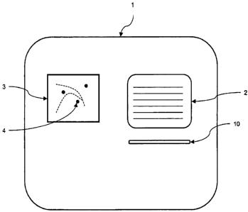
(0082] Fig. I schematically represents a graphical user interface for
displaying a
spatial thumbnail and a document summary to a user.
100831 Fig. 2 is a high level flow diagram of a computer-implemented method of
displaying information about a media object.
100841 Fig. 3 schematically represents a graphical user interface for
displaying an
integrated summary to a user.
[0085] Fig. 4 schematically represents a graphical user interface for
displaying spatial
thumbnails for media objects referenced in search results.
100861 Fig. 5 is a high-level flow diagram of a computer-implemented method of
displaying information about media objects referenced in search results.
[0087] Fig. 6 schematically represents a system for generating spatial
thumbnails,
executing searches, and generating location-related content for digital media
objects.
100881 Fig. 7 schematically depicts a graphical user interface for displaying
information about media objects referenced in search results.
Detailed Description
Overview
100891 A "spatial thumbnail" is a visual summary of location-related content
in a
media object, such as a document or video. A spatial thumbnail is an image or
other
form of media containing indicators of places and spatial relationships that
connote,
indicate, or otherwise prompt recognition of location-related content
associated with a
22
CA 02641986 2008-08-08
WO 2007/095224 PCT/US2007/003769
media object. The location-related content may be explicitly referenced in the
media,
such as specific place names or spatial coordinates, or it may be implied by
association,
such as organizational associations of the authors or protagonists in the
associated media
object, historical events depicted in the associated media object, genre of
the associated
media object or other attributes that connote location-related content or
spatial
relationships. The spatial thumbnail may summarize this location-related
content
explicitly on a map image using cartographic symbology or it may depict an
approximate
spatial sketch of the location-related content. Alternatively, a spatial
thumbnail may
present audio or video to illuminate the location-related content of a media
object. A
spatial thumbnail may be integrated with other summarizing elements to form an
integrated summary. A companion map is similar to a spatial thumbnail except
that it
accompanies the full content of the media object to which it is associated.
Spatial Thumbnails for pocument Summaries
100901 Documents are an important type of media object. Digital documents
occur
frequently in modem life, both in work and non-work environments. Spatial
thumbnails
of documents enable several useful thought patterns and work flows that would
be
difficult without spatial thumbnails. For example, web sites owned by
newspaper
companies typically organize their front page visual display to help their
visitors assess
which news stories are more interesting or important than others. Given
limited display
space and limited attention span of users, such web sites typically present
very short
summaries of the news stories. The success of the news site in serving its
content to
content consumers and the success of the consumers in finding content they
desire is
largely determined by the quality of the summaries presented. By including a
spatial
thumbnail as a component in such an integrated summary, a web site can give
its users a
different perspective on the content without forcing the user to spend time
loading or
viewing the associated media object in its entirety.
100911 For example, consider two news stories about fishing licenses in the
Bay of
Fundy. One may refer to locations along the shore of Maine and the other to
Nova Scotia
and Grand Mannan Island. While a news paper web site may contain both
articles, the
23
CA 02641986 2008-08-08
WO 2007/095224 PCT/US2007/003769
space allotted to describing the two articles might only permit twenty words
per article,
which is not enough to describe the content of the story and the list of
places referenced.
However, displaying, for example, a fifteen word extract of the document
instead of
twenty words, and using the extra space to show a small spatial thumbnail a
geographic
map image of the area with markers on the locations referenced in one or the
other article
can communicate this location-related information without consuming additional
space
on the front page.
100921 As another example, consider a document describing the detailed
behavior of
birds in some parts of South America. Such a document might be stored in an
online
archive that charges for access to its documents, and thus only presents
summary information to prospective customers. Without a spatial thumbnail,
these would-be
customers would not know whether the document discusses specific sub-regions
of the
large region of South America that matter to their particular interests. A
spatial
thumbnail could simply be a listing of salient place names from the document,
or it could
be a spatial thumbnail image showing such salient locations.
100931 Fig. 1 schematically illustrates a graphical user interface (GUI) (1)
for a
"thumbnail" software system that allows users to visualize spatial
information, in the
form of spatial thumbnails, within media objects such as digital documents.
The GUI
includes two "areas" for displaying information about a media object to a
user: a spatial
thumbnail (3) representing spatial information within the media object, and a
summary
(2) of the media object. The spatial thumbnail (3) graphically displays an
image
representing location-related content and/or spatial relationships described
in the media
object. More specifically, the spatial thumbnail (3) includes an image of a
spatial
domain, e.g., a geographical map, and one or more markers (4) on the image
that
represent locations or spatial relationships described or referenced by the
media object,
such as points representing cities, or polylines representing routes from
location to
another. The summary (3) is a succinct representation of the media object, or
of a sub-
media object within the media object, for example an excerpt from the media
object, a
review of the media object, or an image of the media object or a portion of
the media
object. Together, the spatial thumbnail (3) and summary (2) allow users to
quickly assess
24
CA 02641986 2008-08-08
WO 2007/095224 PCT/US2007/003769
whether the media object is of interest to them, e.g., whether the media
object references
geographical locations, and subject matter, of interest. Optionally, the GUI
also includes
a reference (10) to the media object, such as a hyperlink or bibliographic
citation
information, which the user can use to access the full media object.
100941 Fig. 2 is a high-level flow diagram of steps the thumbnail software
system
takes to display information about a given media object. First, the thumbnail
software
system receives a request to display information about the media object (200).
For
example, the user may click on a hyperlink referencing a book he is
considering
purchasing, which invokes the thumbnail software system, causing it to display
a
summary and spatial thumbnail of the media object as described in greater
detail below,
and thus helping the user assess whether he wants to buy the book. Next, the
thumbnail
software system obtains the sununaryof the media object (210). Depending on
the
particular application and the type of media object, the thumbnail software
system may be
associated with algorithms that generate the summary of the media object when
the user
requests information about the media object; or, the summary may have been
previously
generated by a separate system, and simply stored in a summary repository from
which
the thumbnail software system obtains it.
100951 Next, the thumbnail software systein obtains the spatial thumbnail for
the
media object (220), based on location-related content describing location
references or
spatial relationships described by or relating to the media object. In some
embodiments,
the system does this by first obtaining location-related content associated
with the media
object (222), such as coordinates for a location referenced within the media
object. If the
media object refers to multiple locations, the location-related content can
represent
locations corresponding to some or all of these references. As discussed in
greater detail
below, the location-related content can be generated on the fly, e.g., by
software systems
associated with or incorporated into the thumbnail software system, or it can
be obtained
from a repository of previously generated location-related content for media
objects.
[0096] The thumbnail software system then generates an image based on the
location-
related content (224). The image represents a spatial domain relevant to the
location-
CA 02641986 2008-08-08
WO 2007/095224 PCT/US2007/003769
related content, e.g. a colorful digital backdrop geographic map image showing
a
geographic domain encompassing location(s) described by the location-related
content
associated with the media object. For example, if the location-related content
associated
with the media object represents multiple locations in a selected sub-domain
of Japan,
appropriate backdrop maps include a geographic map image of the entire country
of
Japan, or a map of the selected sub-domains of Japan. The system generates the
map by
obtaining it from a map repository or other map image generating system, and
optionally
resizing or otherwise modifying the extent of the domain represented by the
image so as
to appropriately represent a relevant sub-domain containing some or all of the
location
references described by the location-related -content associated with the
media object. For
example, the system could generate a geographic map image by obtaining
information
from a geographical database that the system then uses to render an
appropriate image.
(0097] The thumbnail software system then optionally generates visual
indicator(s) to
represent the location(s) and spatial relationships described in the location-
related content
(226). The thumbnail software system selects the visual indicators based on
the number
and kind of locations and spatial relationships described in the location-
related content.
For example, if the location-related content describes multiple cities in a
oountry, the
system may indicate the locations of those cities using circular image symbols
superimposed on a geographical map image at the approximate locations of those
cities.
For another example, if the location-related content represents a specific
area of a given
city, the system may display a polygon that approximates the shape of the
city. For
another example, if the location-related content represents a route taken
along a river and
up a road from one town to another, then the system may display a polyline in
the image
that it generates.
[00981 The thumbnail software system then simultaneously displays the spatial
thumbnail, and the summary of the media object, to the user (230), e.g., as
illustrated in
Fig. 1.
[0099] In other embodiments, the thumbnail software system does not generate
the
spatial thumbnail, but obtains a previously generated spatial thumbnail from
an
26
CA 02641986 2008-08-08
WO 2007/095224 PCT/US2007/003769
appropriate repository, e.g., database. If the media objects are digital, and
collectively
stored in a repository, then the spatial thumbnails can be stored with the
media objects in
the repository and then obtained for display in the GUI, thus obviating the
need to
dynamically generate the spatial thumbnails each time the user wishes to view
information about the media objects.
[0100] The location-related content associated with the media object, which
the
thumbnail software system uses to generate the spatial thumbnail for the media
object,
may be generated by a "geoparsing" software system that parses the media
object (or
information about the media object) and uses appropriate analytical tools to
determine
what location references and spatial relationships the media object contains
or describes.
Based on the locations and spatial relationships that the analysis identifies,
the parsing
software system then generates a location-related content that describes the
appropriate
infonmation in terms of domains, sub-domains, and relationships between
entities in a
metric space. For example, if the media object references "Cambridge,
Massachusetts,"
the parsing software system generates a location-related content representing
the
geographic coordinates (-71.10161, 42.375). Or, for example, if the media
object
describes that "the aliens traveled from Qidmore Downs to Estheral Hill," the
parsing
software system generates a location-related content representing not only the
geographic
coordinates of the two locations, but also information ordering the two
locations, and
optionally information regarding a route between the two locations. For some
media
objects, the location-related content includes both references to locations
and also spatial
relationships.
[0101] The parsing software system may associate the generated location-
related
content with the media object, e.g., by adding the location-related content to
the media as
"metadata," by storing the location-related content in a database along with
the media
object, or by indexing the location-related content with a reference to the
media object.
In other words, the parsing software system stores the location-related
content, and thus a
representation of location(s) referenced by or relating to the media object,
in an indexed
database that the thumbnail software system can later access in order to
generate a spatial
thumbnail for the media object. Thus, the location-related content need not be
generated
27
CA 02641986 2008-08-08
WO 2007/095224 PCT/US2007/003769
each time the thumbnail software system generates a spatial thumbnail for the
media
object. Alternately, the parsing software system can be directly associated
with the
thumbnail software system, in order to generate location-related content for
media objects
as users request information about the media objects. In other words, the
parsing
software system can be configured to generate location-related content in
response to
requests for information about media objects, and to pass the location-related
content to
the thumbnail software system for use in generating spatial thumbnails.
[0102] The GeoParser software described in U.S. Patent No. 7,117,199, the
entire
contents of which are incorporated herein by reference, is one example of a
parsing
software system that automatically generates location-related content for
digital media
objects. There are a great variety of geoparsing engines. Some simply
recognize
latitude-longitude coordinate metadata stored inside of media objects, such as
the headers
and auxiliary files of GeoTIFF images. Others geoparsing engines recognize
street
addresses contained in specially designated fields in databases associated
with
documents. More advanced geoparsing engines use natural language processing to
recognize when substrings of a document were intended by the author to refer
to specific
locations, such as "twentymiles north of al Hamra," where the phrase "al
Hamra" could
have meant the color read or it could have meant one of many small towns and
villages in
the Middle East, which the geoparsing engine must differentiate between in
order to
resolve the location reference to a specific location in a geographic domain.
[0103[ Note that the media object itself need not be stored in a database
accessible to
the thumbnail software system, or cven be stored in a digital format. The
media objects
simply need to have an associated location-related content that the thumbnail
software
system can use to generate a thumbnail, and a summary that the thumbnail
software
system can display to the user. The location-related content can be
automatically
generated using a geoparsing engine or other appropriate parsing software
system, or can
be manually generated and digitally associated with the document in a database
that the
thumbnail software system can access. Thus, the thumbnail software system can
generate
spatial thumbnails for a wide variety of media objects, such as digital
documents, living
organisms, paper documents, text documents, rocks, videos, email messages, web
pages,
28
CA 02641986 2008-08-08
WO 2007/095224 PCT/US2007/003769
slide show presentations, spreadsheets, rendering of equations, and music. If
the media
object is digital, e.g., digital text, digital images, graphs, numbers, binary
data, or other
signals, an appropriate parsing software system can be used to automatically
generate
location-related content for the object.
Spatial Thumbnails for Book Summary Pages
101041 A book is a special type of document, because books are often large and
thus
include many sub-media objects, e.g., chapters, paragraphs, and images. The
aggregate
value of the large number of sub-media objects typically contained in a book
makes
books a particularly valuable type of document. Spatial thumbnails of books
are
particularly valuable types of spatial thumbnails both because books are often
valuable
and because they contain large amounts of information, which is often
difficult to
summarize in a small amount of space in a visual display.
101051 To find information in books, traditional text search engine techniques
are
often insufficient, because the sheer quantity of information in a book is
typically poorly
summarized by the short summaries traditionally provided by text search result
listings.
To remedy this, book search engines often provide larger "integrated
summaries" of a
book's content. For example, an integrated summary for a book may show several
textual
excerpts from different chapters, an image of the cover of the book or of
pages from the
book, and text from reviewers describing the book. By containing many
summaries, such
an integrated summary may cover or represent most or even all of the
infonmation present
in the book.
101061 Such an integrated summary may contain sub-media objects excerpted from
the book, reviews from people who read the book, images of pages from the
book, images
from the book, and other perspectives on the book.
101071 Spatial thumbnails add useful information to integrated summaries for
books
and other relatively lengthy media objects, by allowing a user to quickly
assess location
references within the book. For example, a spatial thumbnail that summarizes a
book like
"Around the World in Eighty Days" allows would-be readers of the book to
appreciate
29
CA 02641986 2008-08-08
WO 2007/095224 PCT/US2007/003769
the full significance of traveling around the entire world, without needing to
browse
multiple sections or summaries of the book.
101081 Similarly, guidebooks about Australia tend to cover different areas of
the
massive land with differing levels of depth. Even if two guidebooks with
otherwise
similar summaries, a traveler interested primarily in the area of New South
Wales can
differentiate between the two if a spatial thumbnail for one of the books
shows a much
greater density of locations in that area of interest.
[0109J Fig. 3 schematically illustrates a GUI (5) for a thumbnail software
system that
allows users to visualize spatial information from a book via an integrated
summary. The
GUI includes a first summary area (6) including first spatial thumbnail (3)
associated with
a first sub-media object (2) from the book, e.g., a first fragment of text
from the book; and
a second summary area (7) including a second spatial thumbnail (3') associated
with a
second sub-media object (2') from the book. The first and second sub-media
objects are
associated with first and second sets of location-related content. The
thumbnail software
system obtains the first and second spatial thumbnails (3) and (3'), which
respectively
represent spatial information associated with the first and second sub-media
objects (2)
and (2'), as described in greater detail above. Because the first and second
sets of
location-related content can represent different spatial references, the first
and second
spatial thumbnails can represent different locations, e.g., have different
maps and/or
different markers (4).
[01101 GUI (5) can also be used to show summaries and spatial thumbnails
associated
with two separate media objects, e.g., books, and thus allow users to
simultaneously
visualize spatial information related to different media objects. In this
embodiment, the
first summary area (6) includes a first spatial thumbnail (3) and a first
summary or sub-
media object (2), associated with a first media object; and the second summary
area (7)
includes a second spatial thumbnail (3') and a second summary or sub-media
object (2'),
associated with a first media object. The GUI can also include first and
second references
(not shown) to the first and second media objects, e.g., hyperlinks to the
media objects,
hyperlinks to more detailed summaries of the media objects, or bibliographic
information
CA 02641986 2008-08-08
WO 2007/095224 PCT/US2007/003769
about the media objects, thus allowing the user to learn more about the media
object after
viewing its summary.
Spatial Thumbnails for Search Results
(01111 Search engines accelerate learning, commerce, and other aspects of
daily life.
While the conventional generation of a list of references that allow people to
retrieve
media objects is important, a fundamental component of the usefulness of
search engines
is the summarizing nature of the search results themselves.
101121 Spatial thumbnails can enhance the presentation of search results
referencing
media objects with significant location information. For example, when using a
free text
based search engine, a user could enter a query for "exotic fruit farms" and
receive a
listing of millions of web pages mentioning those words. With only
conventional textual
summaries, the user would be forced to guess which search results refer to
places that
they consider interesting. Including a spatial thumbnail in an integrated
summary
alongside the textual summary for each document referenced in a search result
makes it
possible for users to detect in a single glance whether a document contains
location
references of interest to them. This is superior to forcing the user to enter
keywords
associated with places of interest to them, because with the inclusion of
spatial
thumbnails the user can type a shorter, simpler query string and still
understand the
spatial significance of the returned results.
101131 Fig. 4 schematically illustrates a GUI (6) for a thumbnail software
system
associated with a search engine that allows users to visualize spatial
information
associated with search results. The GUI includes a text entry box (8) to
accept free text
queries from a user, and a "submit" button (8') that the user can click to
pass a query to
the search engine. Alternatively, the user can simply hit "ENTER" on his
keyboard to
pass a query to the search engine. The search engine returns the results to
the thumbnail
software system, which then obtains a spatial thumbnail for search results
associated with
media objects that reference spatial information. Fig. 4 illustrates the
result of a free text
query that generates two search results associated with media objects that
each references
spatial information, e.g., geographical locations, and thus has a spatial
thumbnail. First
31
CA 02641986 2008-08-08
WO 2007/095224 PCT/US2007/003769
result area (6) is associated with a first search result referencing a first
media object, and
second result area (7) is associated with a second search result referencing a
second media
object. First result area (6) includes a summary of a first media object (2),
a reference to
the first media object (10), and a first spatial thumbnail (3) representing a
spatial
reference within the first media object. Second result area (7) includes a
summary of a
second media object (2'), a reference to the second media object (10'), and a
second
spatial thumbnail (10') representing a spatial reference within the second
media object.
Displaying a spatial thumbnail associated with a conventional search result,
e.g., a brief
media object summary and reference to the media object, allows the user to
more quickly
assess the relevance of the link to the user's interest.
[0114] Fig. 5 is a high-level flow diagram of steps that a thumbnail software
system,
associated with a search engine, uses to display search results and spatial
thumbnails
associated with the search results. First, the thumbnail software system
receives a query
from a user (500), e.g., via a free-text query box presented to the user. The
thumbnail
software system then transmits the query to a search engine, and obtains the
results from
the search engine (510). When the search engine receives the query from the
thumbnail
software system, it generates a list of search results that reference media
objects, e.g.,
media objects that exist in a database with which the search engine is in
communication,
or on the World Wide Web. Digital documents and web pages are examples of
searchable media objects. Each search result includes a reference to the media
object,
e.g., a hyperlink and/or bibliographic information that the user can use to
directly access
the media object, and optionally also includes a summary of the media object.
For
example, some search engines generate or otherwise obtain a summary for media
objects
referenced in search results.
[0115] After obtaining the search results from the search engine, the
thumbnail
software system obtains spatial thumbnails for search results referencing
media objects
that have spatial references (520), e.g. using the systems and methods
described above.
Briefly, the system first obtains location-related content associated with the
media object
(522). The location-related content represents one or more locations
corresponding to
one or more spatial references within the media object; if the media object
does not have
32
CA 02641986 2008-08-08
WO 2007/095224 PCT/US2007/003769
spatial references, it does not have associated location-related content. The
thumbnail
software system then generates an image of a spatial domain, e.g., a map,
based on the
location-related content (524), and optionally generates visual indicators
representing the
location-related content (526). In other embodiments, the system obtains a
spatial
thumbnail that was previously generated and associated with the media object,
e.g., from
a database, as discussed in greater detail above.
[0116] The thumbnail software system then displays the search results and the
spatial
thumbnails obtained for search results referencing media objects having
spatial references
(530), e.g., as illustrated in Fig. 4. It will be apparent that searches
generally result in an
arbitrary number of search results, and that not all search results will
necessarily reference
spatial information, so the thumbnail software system will not necessarily
obtain a spatial
thumbnail for all displayed search results.
[0117] Fig. 6 schematically illustrates a system for generating spatial
thumbnails,
executing searches, and generating location-related content for digital media
objects. The
system includes a thumbnail software subsystem (20), a search engine subsystem
(12), a
parsing software subsystem (11), and a document repository (13) that stores
digital media
objects, e.g., a database or the World Wide Web. The thumbnail software
subsystem (20)
communicates with the search engine subsystem (12) via communication link
(16), and
communicates with parsing software subsystem (11) via communication link (18).
The
search engine subsystem (12) communicates with document repository (13) via
communication link (15). The parsing software subsystem communicates with
document
repository (13) via communication link (14).
101181 The thumbnail software system (20) generates a GUI for accepting
queries
from a user and displaying to the user search results based on the queries,
and spatial
thumbnails associated with at least some of the search results, e.g., the GUI
illustrated in
Fig. 4. The thumbnail software system (20) obtains the content for the GUI by
interworking with the search engine subsystem (12) and the parsing software
system (11).
In operation, when the user enters a query into the GUI, the thumbnail
software system
(20) forwards the query to the search engine subsystem (12) via communication
link (16).
33
CA 02641986 2008-08-08
WO 2007/095224 PCT/US2007/003769
The search engine subsystem (12) process the query, generates search results
based on the
query, and transmits the search results to the thumbnail software subsystem
(20) via
communication link (16). The search results each include a reference to a
media object.
101191 Responsive to receiving the search results, the thumbnail software
subsystem
(20) attempts to obtain a spatial thumbnail for each media object referenced
in a search
result. The thumbnail software subsystem (20) transmits the references to the
media
objects referenced in the search results to parsing software subsystem (11)
via
communication link (18). The parsing software subsystem (11) analyzes the
media
objects, and generates location-related content for media objects as
appropriate, e.g., for
media objects that reference locations or spatial relationships. The parsing
software
subsystem (11) then transmits to the thumbnail software subsystem (20) the
location-
related content for the media objects referenced by the search results.
Depending on its
configuration, the parsing software subsystem (11) might not generate location-
related
content for every media object that reference locations or spatial
relationships, for
example if the parsing software subsystem (11) determines that the reference
is
insufficiently relevant to warrant expression in a spatial thumbnail; for such
media
objects, the parsing software subsystem (11) retums a null result to the
thumbnail
software subsystem (20).
101201 Based on the location-related content obtained from the parsing
software
subsystem (11), the thumbnail software subsystem (20) obtains spatial
thumbnails for
media objects associated with location-related content as described in greater
detail
herein. The thumbnail software system (20) then displays the search results
and the
obtained spatial thumbnails to the user via the GUI.
101211 Fig. 7 schematically illustrates a GUI (27) displaying the results of a
search
performed for the query "tree farm." The GUI (27) includes a text entry box
(24)
containing the query "tree farm" (23), a "submit" button (25), a plurality of
search results
that include references to media objects (22), e.g., web pages, summaries of
the media
objects (26), and a plurality of spatial thumbnails (20) adjacent the
corresponding
summaries (26) and references (22). As illustrated in Fig. 7, the result for
"Bent Tree
34
CA 02641986 2008-08-08
WO 2007/095224 PCT/US2007/003769
Farms" does not have an associated spatial thumbnail, and the GUI simply
displays a
blank space (21) in the area adjacent the summary (26) and reference (22) for
that search
result, where a spatial thumbnail would otherwise have been displayed.
101221 The query received from a user may come in several forms. Any type of
user
input that may be transformed into a database query in the commonly used
"Structured
Query Language" ("SQL") could be a query. Examples include, free-text input,
selecting
one or more options from a list of options offered to the user, and selecting
a variety of
different options from different options lists and submitting the combined set
of options
to the computer system as a query. For example, a web site might offer several
"categories" of content that a user can choose amongst by navigating to
different links
presented in a web page. By navigating through a particular sequence of links,
the user
constructs a query comprised of the selections made in navigating the links.
The resulting
query is then processed by the computer system generating the web page, and a
set of
search results are presented to the user in the resulting web page. The page
typically
contains means of issuing additional queries to generate additional result
sets. Any of
these means of entering queries can generate search results accompanied by
spatial
thumbnails for the media objects referenced in the generated search results.
(0123] Some embodiments utilize a web browser user interface. To display
spatial
thumbnails in a search listing, the user interface display connects together
different parts
of the system. For example, a listing of search results may be displayed to a
user via a
web browser that displays HTML. The HTML may be generated by a script that
accepts
user queries via CGI parameters in the URL that requests the HTML. The script
passes
the user query to a secondary process that generates the search result listing
in a computer
readable form, such as an array of data records. The data records typically
include
several data elements, including a URL to the original media object, a URL to
a copy of
the media object that the search engine has cached, a excerpt or fragment or
other form of
summary about the media object, or possibly a URL or other type of reference
to such a
summary of the media object. The script processes this information to produce
an HTML
representation that it passes to the user's web browser. The web browser
renders the
HTML into a visual display. CGI is a common gateway interface and is standard
in the
CA 02641986 2008-08-08
WO 2007/095224 PCT/US2007/003769
art. URL is a universal resource locator and is standard in the art. HTML is
the hyper-
text markup language and is standard in the art.
101241 The visual display is typically a list of visual arrays arranged in an
orderly
fashion on the page, such as one item per row or in a grid of boxes stacked on
the screen.
And for each row or grid cell, information for a specific result is displayed.
[0125] Spatial thumbnails can be included in the search result listing by
creating the
script such that for every element in the array of search results, it includes
an HTML IMG
tag in the tow or grid cell displaying infon-nation for that result. An HTML
IMG tag is
standard in the art and is an instruction to the web browser that causes the
browser to load
an image from a source URL. The source URL is designated within the HTML IMG
tag.
For example, this is an HTML IMG tag that would instruct a web browser to load
the
image associated with the URL "http://metacarta.com/imagel.png"
<lMG SRC="http://metacana.com/imagel.png" />
[0126] By including these in the result listing, the script that arranges the
search
results can request images that may not have been generated yet. This provides
an
abstraction layer between the script generating the search results display and
the
thumbnail software system. The image source URLs included in the result
listing could
be to images that already exist or the system specified by the image source
URL may
generate the images on the fly.
(01271 In order to request a spatial thumbnail of a particular media object,
the image
source URL must somehow specify or encode a reference to the media object, so
the
thumbnail software system can interpret the URL request and respond with the
right
spatial thumbnail. One way of doing this is to pass a URL for the media object
in an
encoded format inside the image request URL. Here's an example of passing a
URL
encoded inside of another URL:
<IMG SRC="http://metacarta.com/thumbnail?url=http://news.com/article I .html"
/>
36
CA 02641986 2008-08-08
WO 2007/095224 PCT/US2007/003769
101281 The thumbnail software system can then interpret the "tirl=" parameter
which
contains the value "http://news.com/articlel.html" and generate a spatial
thumbnail for
that media object. If the thumbnail software system determines that a
particular media
object does not have location-related content associated with it, or that the
location related
content associated with it is not appropriate for a particular situation, it
can respond with a
blank image. Such a blank image might be a transparent image that allows the
background color of the search result listing's HTML page to show through to
the user, or
'it might simply be white.
[0129] Often, the URL for requesting the spatial thumbnail will also allow the
requestor to specify additional parameters, such as:
=. ,. a width and height of the desired image
= a designation for a given spatial domain, such as "Earth" or "Mars" so that
the
thumbnail software system can prepare a map image of the desired spatial
domain
~ a flteririg extent, which is a location reference to a location within a
given spatial
domain: If a filtering extent is passed, it instructs the thumbnail system to
only
display locations from the location-related content associated with the media
object if those locations are contained within the filtering extent.
= a selection of which data layers to use in constructing the map image
= a particular color to use for blank images, so that they blend into the HTML
page
seamlessly.
101301 The value of the blank images is that it allows the script constructing
the
search results to ignore the possibility that some of the media objects may
not get a spatial
thumbnail. The script simply causes the browser to request a spatial thumbnail
for every
result listing, and then allows the thumbnail system to fill in the space with
an invisible
image if no spatial thumbnail is available for a given media object in the
list.
37
CA 02641986 2008-08-08
WO 2007/095224 PCT/US2007/003769
101311 The user query passed to the script may be of a wide variety of fonns.
For
example, a query may be only free text, or it may be a selection from a fixed
list of
choices. For example, a site may offer users a list of categories of content
in a list. By
selecting an item from the list, the user issues a query that retrieves a list
of one or more
items. A query may be a free text query combined with a spatial domain
constraint as
described in U.S. Patent No. 7,117,199.
[01321 When working with multiple media objects, such as in a search result
listing
that lists references many media objects, it is sometimes appropriate to
generate a spatial
thumbnail that depicts location-related content from more than one of the
media objects.
For example, when displaying a list of search results for a user's query for
the word "tree
farm" the system can generate a single spatial thumbnail showing locations
from the
location-related content associated with each of the top five documents.
[01331 When generating a spatial thumbnail, the location-related content may
contain
a large number of locations. By analyzing the media object using either human
evaluators or automatic algorithms, the thumbnail software system can decide
that a
subset of the location-related content is more important or more pertinent to
the media
object. These locations are said to have higher "relevance," and when
generating the
spatial thumbnail, the system may choose to only display a subset of the
location-related
content that is higher relevance than other subsets. By focusing the
thumbnail's display
on higher relevance location-related content, the system can direct the user's
attention to
the most important aspects of the location-related content. For example, a
document
about Japan might also mention Moscow, but only tangentially. By analyzing the
relevance of the different locations referenced in the document, the system
may decide to
show a map image that only covers Japan and excludes Moscow.
101341 The software systems described herein can be run on conventional
computers,
including memory, storage media, input devices, processors, display devices,
and the like.
[0135] A number of embodiments of the invention have been described.
Nevertheless, it will be understood that various modifications may be made
without
38
CA 02641986 2008-08-08
WO 2007/095224 PCT/US2007/003769
departing from the spirit and scope of the invention. Accordingly, other
embodiments are
within the following claims.
101361 What is claimed is:
39