Note: Descriptions are shown in the official language in which they were submitted.
CA 02675454 2009-07-10
WO 2007/082011
PCT/US2007/000678
VISUAL MAPPING OF FIELD DEVICE MESSAGE ROUTES IN
A WIRELESS MESH NETWORK '
BACKGROUND OF THE INVENTION
The present invention relates to wireless networks. In
particular, the invention relates to a wireless mesh network in which process
control messages are communicated between a host and field devices at
nodes of the wireless mesh network.
In many industrial settings, control systems are used to
monitor and control inventories, processes, and the like. Often, such control
systems have a centralized control room with a host computer that
communicates with field devices that are separated Or geographically
removed from the control room_
Generally, each field device includes a transducer, which may
generate an output signal based on a physical input or generate a physical
output based on an input signal. Types of transducers used in field devices
include various analytical equipment, pressure sensors, thermistors,
thermocouples, strain gauges, flow sensors, positioners, actuators, solenoids,
indicators, and the like.
Traditionally, analog field devices have been connected to the
process subsystem and the control room by two-wire twisted-pair current
loops, with each device connected to the control room by a single two-wire
twisted pair loop. Typically, a voltage differential is maintained between the
two wires of approximately 20 to 25 volts, and a current between 4 and 20
milliamps (mA) runs through the loop. An analog field device transmits a
signal to the control room by modulating the current running through the
current loop to a current proportional to the sensed process variable. An
analog field device that performs an action under the control of the control
room is controlled by the magnitude of the current through the loop, which is
modulated by the ports of the process subsystem under the control of the
controller.
While historically field devices were capable of performing
only one function, more recently hybrid systems that superimpose digital
data on the current loop have been used in distributed control systems. The
CA 02675454 2009-07-10
WO 2007/082011 PCT/US2007/000678
2
Highway Addressable Remote Transducer (HART) superimposes a digital
carrier signal on the current loop signal. The digital carrier signal can be
used to send secondary and diagnostic information. Examples of information
provided over the carrier signal include secondary process variables,
diagnostic information (such as sensor diagnostics, device diagnostics,
wiring diagnostics, process diagnostics, and the like), operating
temperatures, sensor temperature, calibration data, device ID numbers,
configuration information, and so on. Accordingly, a single field device may
have a variety of input and output variables and may implement a variety of
functions.
Another approach uses a digital communication bus to
connect multiple field devices to the host in the control room., Examples of
digital communication protocols used with field devices connected to a
digital bus include Foundation Fieldbus, Profibus, Modbus, and DeviceNet.
Two way digital communication of messages between a host computer and
multiple field devices can be provided over the same two-wire path that
supplies power to the field devices.
Typically, remote applications have been added to a control
system by running very long homerun cables from the control room to the
remote application. If the remote application is, for example, a half of a
mile
away, the costs involved in running such a long cable can be high. If
multiple homerun cables have to be run to the remote application, the costs
become even higher. Wireless communication offers a desirable alternative,
and wireless mesh networks have been proposed for use in industrial process
control systems. However, to minimize costs, it is also desirable to maintain
existing control systems and communication protocols, to reduce the costs
associated with changing existing systems to accommodate the wireless
communication.
In wireless mesh network systems designed for low power
sensor/actuator-based applications, many devices in the network must be
powered by long-life batteries or by low power energy-scavenging power
sources. Power outlets, such as 120VAC utilities, are typically not located
nearby or may not be allowed into the hazardous areas where the
CA 02675454 2009-07-10
WO 2007/082011 PCT/US2007/000678
3
instrumentation (sensors) and actuators must be located without incurring
great installation expense. The need for low installation cost drives the need
for battery-powered devices communicating as part of a wireless mesh
network. Effective utilization of a limited power source, such as a primary
cell battery which cannot be recharged, is vital for a well functioning
wireless device. Batteries are expected to last more than 5 years and
preferably as long as the life of the product.
In a true wireless mesh network, each node must be capable
of routing messages for itself as well as other nodes in the mesh network.
The concept of messages hopping from node to node through the network is
beneficial because lower power RF radios can be used, and yet the mesh
network can span a significant physical area delivering messages from one
end to the other. High power radios are not needed in a mesh network, in
contrast a point-to-point system which employs remote nodes talking directly
to a centralized base-station.
A mesh network protocol allows for the formation of alternate
paths for messaging between nodes and between nodes and a data collector,
or a bridge or gateway to some higher level higher-speed data bus. Having
alternate, redundant paths for wireless messages enhances data reliability by
ensuring there is at least one alternate path for messages to flow even if
another path gets blocked or degrades due to environmental influences or due
to interference.
Some mesh network protocols are deterministically routed
such that every node has an assigned parent and at least one alternate parent.
In the hierarchy of the mesh network, much as in a human family, parents
have children, children have grandchildren, and so on. Each node relays the
messages for their descendants through the network to some final destination
such as a gateway. The parenting nodes may be battery-powered or limited-
energy powered devices. The more descendants a node has, the more traffic
it must route, which in turn directly increases its own power consumption
and diminishes its battery life.
CA 02675454 2009-07-10
WO 2007/082011
PCT/US2007/000678
4
BRIEF SUMMARY OF THE INVENTION
Performance of a wireless mesh network having a
plurality of nodes can be assessed using a visual representation of the
network that shows graphically the positions of the nodes and links
between nodes used to route messages through the mesh network. The
visual representation is based upon positional information relating to the
nodes and network performance parameters that are collected from the
nodes.
Network performance parameters can include, for
example, identification of other nodes with which a particular node has
established communication links, radio signal strength on each of the
links, number of lost messages or other errors on each link, and how
often communication occurs on each of the links. The visual
representation allows the user to inspect the communication paths within
the mesh network to identify potential problems and to make
adjustments to the network to improve communication performance.
BRIEF DESCRIPTION OF THE DRAWINGS
FIG. I is a diagram illustrating a control system in which
a wireless mesh network routes wireless messages between a host and
field devices.
FIG. 2 is a flow chart of a method of providing a
graphical visualization of message routing and network performance of
a wireless mesh network.
FIGS. 3A and 3B are a visual network map of the
wireless mesh network of FIG. 1, formed using positional information
and performance statistics obtained from nodes of the wireless network
at different times.
FIGS. 4-6 show alternative visual network maps.
DETAILED DESCRIPTIO
This invention provides a method for graphically visualizing
the route a message takes as it passes between nodes in a wireless mesh
network. In a typical control system, a host computer at a control center
interacts with field devices located within a physical plant and displays
CA 02675454 2009-07-10
WO 2007/082011
PCT/US2007/000678
information they have to offer. The communication of messages between the
host computer and the field devices can be over wired connections or over a
wireless mesh network. In a low power wireless mesh network, a device
message does not pass from the host to the target field device directly; it
can
5 take a multitude of routes within the wireless mesh network before
reaching
its destination. In practice, it is desirable to understand the routes
messages
take through the wireless mesh network so that the topology of the physical
network can be adjusted if needed to enable the network to communicate in a
more desirable way. Presently there is no way = for a qualified person to
inspect the dynamic nature of the wireless mesh network and see this type of
information so that adjustments could be made or potential problems
identified. This invention is a graphical method to display the routes field
device messages take as they travel through a wireless mesh network on their
way to their destinations. The user can be provided a visual representation of
the wireless network (i.e. a visual network map) in which each node of the
network is represented by an icon. Lines are drawn interconnecting the icons
that represent the communication links between wireless nodes. The
graphical display can be dynamic in nature, in that the paths through the
network will be updated in real time based upon network performance data
collected from the nodes.
FIG. 1 shows control system 10, which is an example of a
system in which the visual mapping of signal routing in a wireless network
can be used. Control system 10 includes host computer 12, highspeed
network 14, and wireless mesh network 16, which includes gateway 18 and
wireless nodes 20, 22, 24, 26, 28, and 30. Gateway 18 interfaces mesh
network 16 with host computer 12 over highspeed network 14. Messages
may be transmitted from host computer 12 to gateway 18 over network 14,
and are then transmitted to a selected node of mesh network 16 over one of
several different paths. Similarly, messages from individual nodes of mesh
network 16 are routed through mesh network 16 from node-to-node over one
of several paths until they arrive at gateway 18 and are then transmitted to
host 12 over highspeed network 14.
CA 02675454 2015-08-10
6
Control system 10 can make use of field devices that have
been designed for and used in wired distributed control systems, as well as
field devices that are specially designed as wireless transmitters for use in
wireless mesh networks. Nodes 20, 22, 24, 26, 28, and 30 show examples of
wireless nodes that include conventional field devices.
Wireless node 20 includes radio 32, wireless device router
(WDR) 34, and field devices FD1 and FD2. Node 20 is an example of a
node having one unique wireless address and two unique field device
addresses.
Nodes 22, 24, 26, and 28 are each examples showing nodes
having one unique wireless address and one unique field device address.
Node 22 includes radio 36, WDR 38, and field device FD3. Similarly, field
device 24 includes radio 40, WDR 42, and field device FD4; node 26
includes radio 44, WDR 46, and field device FD5, and node 28 includes
radio 48, WDR 49, and field device FD6.
Node 30 has one unique wireless address and three unique
field device addresses. It includes radio 52, WDR 54, and field devices FD7,
FD8, and FD9.
Wireless network 16 is preferably a low power network in
which many of the nodes are powered by long life batteries or low power
energy scavenging power sources. Communication over wireless network 16
may be provided according to a mesh network configuration, in which
messages are transmitted from node-to-node through network 16. This
allows the use of lower power RF radios, while allowing the network 16 to
span a significant physical area to deliver messages from one end of the
network to the other.
In control system 10, host computer 12 interacts with
field devices FD1-FD9, and displays information contained in messages
received from field devices FD1-FD9. In wireless mesh network 16,
messages from host computer 12 to field devices FD1-FD9, and
messages from field devices FD1-FD9 back to host computer 12 can
take multiple routes through network 16 before reaching a final
destination. FIG. 1 shows a simplified system, with only six wireless
CA 02675454 2015-08-10
7
nodes 20-30; it is possible, however, for wireless mesh network 16 to
have many more nodes, and therefore many more potential routes for
messages to travel.
In practice, it is desirable to understand the routes that
messages take through a wireless mesh network, so that that the
topology of the physical network can be adjusted if needed to enable to
the wireless mesh network to communicate effectively. In the past,
users have not been provided with an ability to inspect the dynamic
nature of a wireless mesh network in order to identify strengths and
weaknesses of the network, to diagnose and troubleshoot problems
within the network, to detect changes in network performance that may
be caused by damage to one or more nodes, or to detect changes in
performance due to changes in the physical plant in which the network
operates that can introduce new sources of interference to wireless links
between nodes.
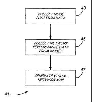
Method 41, illustrated in FIG. 2, provides a tool by which
the user can assess performance of a wireless mesh network in order to
identify potential problems and to take corrective action. Using
positional information indicating the location of each node (step 43) and
performance information gathered from each node (step 45), a visual
representation of the wireless network is generated (step 47). This
visual representation can be a visual network map in which each node of
the network is represented by an icon. Lines can be drawn between
icons to represent communication activity between the nodes. Other
network performance parameters can also be displayed as part of the
map, such as received radio signal strength on each link, error rate over
particular links, and the amount of activity occurring over each link.
The generation of a visual representation of the network
makes use of positional information relating to the nodes in order to
provide a physical layout of the topology of the wireless network. The
positional information can be gathered during installation of the wireless
network. The installer can provide positional information of each node
that is installed. The positional information can be in the form of GPS
CA 02675454 2009-07-10
WO 2007/082011 PCT/US2007/000678
8
coordinates, or can be defined by relative position of the node to other
structures within an actual plant layout. Alternatively, some or all of
the nodes can include embedded GPS sensors, so that the GPS
coordinates of the node can be provided as part of messages sent over
the wireless mesh network. Still another alternative is to establish
positional information for certain nodes within the wireless mesh
network, and then use triangulation techniques in order to derive the
location of other nodes.
The position data is collected and stored in a database.
When new nodes are added to the network, or existing nodes are moved,
the position information must be updated in order for the positions of the
nodes to be accurately portrayed in a visual network map.
The positional information allows a visual network map
to accurately show the relative positions of the nodes of the wireless
mesh network. In addition, the positional information can be used to
map the nodes of the network on to an image of the actual plant layout.
This can be used to show relative location of the nodes to other physical
objects in the plant, which may for example, interfere with
communication between particular nodes.
=
When control system 10 is first initialized, network
performance data is collected from each node. For a given node, the
performance data includes an identification of the nodes with which the
given node has established communication links. The performance data
may also include the number of transmissions occurring over each
established link, how many errors have occurred over each link, and the
signal strength of received signals over each link.
This performance data is reported in messages sent to
gateway 18 and may be stored at gateway 18, or sent on to host
computer 12. In either case, as performance data is collected from each
node, the visual network map can be built up using that data. Once data
has been collected from all nodes, a complete map can be displayed.
In the simplest form, the visual network map shows the
physical location of each node, and the links established by that node
CA 02675454 2009-07-10
WO 2007/082011
PCT/US2007/000678
9
with neighboring nodes. By viewing the nodes and the links, the
pathways over which messages are routed to a particular node (and the
field device located at that node) can be determined.
As the network continues to operate, performance data is
collected so that the visual network map can be updated dynamically.
The collection of performance data from the nodes can occur at
regularly scheduled times, or can,be performed on demand in response
to a command sent to each of the nodes from gateway 18. The on-
demand collection of data may be initiated by a user interacting with
host computer 12.
The display of visual network maps occurs at host
computer 12, although the display can occur at other locations as well.
An application program running on host computer 12 uses the stored
positional information and network performance data to create a visual
network map in one of several different formats, as requested by a user.
As new data is gathered from wireless network 16, the application
dynamically redraws visual network maps by host computer 12.
FIG. 3A shows visual network map 50, which represents
operation of wireless mesh network 16 at a first time. In this example,
visual network map 50 shows each node 20-30 as a square block.
Established communication links L1-L10 between the various nodes 20-
are represented by straight lines between nodes.
In this particular example, other performance data, such
as error rates, signal strengths, or frequency of use of a link are not
25 shown on map 50. However, other versions of the visual network map
can provide that information in various graphical forms. In addition,
visual network map 50 may include capability of a user moving an
arrow or cursor to select a particular link. When a particular link is
selected, a display of performance data specific to that link can be
30 provided. Similarly, selection of a particular node can result in a
display
of network performance information associated with that node. In
addition to the data discussed above, other parameters relating to
operation of the nodes can be displayed. For example, battery life at
CA 02675454 2015-08-10
each node could be checked as part of a visual inspection of the network
using the display.
FIG. 3B shows visual network map 50 at a later time, at
which communication between nodes 24 and 26 is no longer occurring.
5 Link L6 (shown in FIG.
3A) is not present in FIG. 3B. This may be the
result of damage or malfunction at one or the other of the nodes, or by
the introduction of a new source of interference, such as a new piece of
equipment, within the plant where network 16 is installed. By
monitoring changes in the links shown in visual network map 50, a user
10 can identify a
potential problem, and determine what corrective action,
if any, is necessary. For example, the addition of another node in the
vicinity may provide an alternative path to replace the link that no
longer exists directly between nodes 24 and 26. Alternatively, one of
the nodes may need to be repositioned in order to reestablish the link.
FIGS. 4-6 show other display format p and different
numbers of nodes. In FIG. 4, visual network map 60 includes a large
number of nodes N and links L are shown for a system much larger than
control system 10 of FIGS. 1, 3A and 3B. Multiple wireless networks
are shown in map 60. FIG. 5 illustrates visual network map 70, which
includes nodes N and =links L superimposed on plant layout P. In FIG.
6, signal strength charts S are shown as part of map 80. A wide variety
of display formats, using different network performance data, is
available to provide the user with information needed to .assess the
performance of the wireless mesh network.
Although the present invention has been described with
reference to preferred embodiments, workers skilled in the art will recognize
that changes may be made in form and detail without departing from the