Note: Descriptions are shown in the official language in which they were submitted.
CA 02689265 2009-11-27
WO 2008/151065 PCT/US2008/065397
1
AZIMUTHAL MEASUREMENT-WHILE-DRILLING (MWD) TOOL
Paul L. Sinclair
Thomas A. Springer
TECHNICAL FIELD
This invention relates to the field of measurement-while-drilling (MWD)
logging, particularly for
oil and gas development and exploration.
BACKGROUND ART
Logging is a technique that is used to measure one or more characteristics,
such as resistivity, of
subsurface geologic formations. Such a measurement can be used, for example,
to determine the type of
subsurface formation surrounding a drill bit. Accordingly, logging provides
useful information to
engineers and geologists engaged in hydrocarbon exploration and production and
similar fields, such as
mining.
Logging can be performed by inducing a current to flow in a formation and then
selectively
measuring the current distribution. Several different techniques for
performing logging have been
developed. For example, open-hole logging involves in removing the drill pipe
and bit from a wellbore
and then lowering an open-hole logging tool into the wellbore to obtain the
desired measurements.
Measurement-while-drilling (MWD, also known as logging-while-drilling) systems
have also
been developed. These MWD systems differ from open-hole logging in that
measurements can be
obtained while the drill pipe is in the wellbore. MWD systems permit log
information, such as resistivity,
to be measured in a formation very soon after the formation is penetrated by
the drill bit. This provides
substantially "real-time" information that (a) is obtained before the
formation is substantially altered by
inflow of drilling fluids or other factors and (b) may be used by the driller
to control the drilling
operation, for example by steering the bit so as to penetrate (or so as not to
penetrate) a selected
formation detected by the MWD system. MWD systems typically include
transmitters and sensors
disposed in or on sections of drill pipe that are located near the drill bit.
Some existing MWD systems have developed techniques to determine whether the
drill bit is
approaching an anomaly within a formation. However, these techniques generally
lack the ability to
pinpoint the location of the anomaly relative to the drill bit. Such
techniques also lack the ability to
distinguish between a more conductive anomaly on one side of the drill bit and
a less conductive anomaly
on the other side of the drill bit. Accordingly, improved techniques for use
in MWD systems are
desirable.
CA 02689265 2009-11-27
WO 2008/151065 PCT/US2008/065397
2
DISCLOSURE OF INVENTION
Various systems and methods for determining a distance, magnitude, and
azimuthal angle
describing the location of an anomaly within a geologic formation are
disclosed. In one embodiment, a
method involves identifying an electrical characteristic (e.g., resistivity or
conductivity) at each of several
sensors in a measurement-while-drilling (MWD) tool. Based on the electrical
characteristic, information
identifying a formation property of the anomaly is generated. The information
includes at least one
magnitude and at least one distance. Information identifying an azimuthal
angle is also generated based
upon the electrical characteristic. The azimuthal angle relates a position of
the anomalous formation to a
position of a first sensor in the MWD tool. The azimuthal angle can be used to
calculate a relative angle
that relates the position of the anomaly to a known direction (e.g., magnetic
north or the gravity vector).
In embodiments in which the electrical characteristic is conductivity, the
information can be
generated by calculating a ratio of a near current to a far current. The near
current is received by the
sensor closest to the anomaly, while the far current is received by the
furthest sensor from the anomaly.
The magnitude and distance can then be obtained from a lookup table, based
upon the calculated ratio.
The method can also involve determining whether the anomaly is more conductive
or less
conductive than the surrounding geologic formation. This determination can be
made based upon
information that indicates the historical conductivity detected by the MWD
tool in the formation.
Alternatively, this determination can involve identifying which of the sensors
is receiving a greatest or
smallest amount of current.
If the anomaly is more conductive than the geologic formation, the azimuthal
angle can be
identified by generating a conductivity value for each of the sensors,
computing a first difference between
conductivity values associated with a first pair of sensors on opposing sides
of the MWD tool, computing
a second difference between conductivity values associated with a second pair
of sensors on opposing
sides of the MWD tool, and then calculating the arctangent of the ratio of the
first difference to the
second difference.
If instead the anomaly is less conductive than the geologic formation, the
azimuthal angle can be
identified by generating a resistivity value for each of the sensors,
computing a first difference between
resistivity values associated with a first pair of sensors on opposing sides
of the MWD tool, computing a
second difference between resistivity values associated with a second pair of
sensors on opposing sides of
the MWD tool; and then calculating an arctangent of a ratio of the first
difference to the second
difference.
A graphical display can be generated from the information. For example, a
graphic that is based
upon the magnitude, distance, and azimuthal angle can be generated and
displayed on a polar display.
The center of the polar display corresponds to the location of the borehole in
which the MWD tool is
located, and thus the graphic shows the position of the anomaly (or a set of
possible positions of the
anomaly) relative to the borehole. In one embodiment, the graphic comprises
one or more regions. Each
CA 02689265 2009-11-27
WO 2008/151065 PCT/US2008/065397
3
region represents a portion of the geologic formation having a different
conductivity and corresponds to a
respective one of one or more magnitude and distance pairs that are included
in the information (each
magnitude and distance pair corresponds to a respective possible conductivity
of the anomaly).
One or more bands (each corresponding to a respective possible conductivity of
the anomaly) can
be displayed on the polar display. The boundary between bands can be
determined by identifying a
tangent line based upon the azimuthal angle. The tangent line intersects a
circle having a radius equal to
one of the distances. A band, which is bounded by the tangent line, can then
be marked on the polar
display.
The foregoing is a summary and thus contains, by necessity, simplifications,
generalizations and
omissions of detail; consequently those skilled in the art will appreciate
that the summary is illustrative
only and is not intended to be in any way limiting. Other aspects, inventive
features, and advantages of
the present invention, as defined solely by the claims, will become apparent
in the non-limiting detailed
description set forth below.
BRIEF DESCRIPTION OF DRAWINGS
A more complete understanding of the present invention may be acquired by
referring to the
following description and the accompanying drawings, in which like reference
numbers indicate like
features.
FIG. 1 illustrates a drilling system in which embodiments of the present
invention can be
employed.
FIG. 2 is a block diagram illustrating the functionality included in a MWD
tool, according to one
embodiment of the present invention.
FIG. 2A is a cross-sectional view of the MWD tool, illustrating an example
sensor arrangement,
according to one embodiment of the present invention.
FIG. 2B is a cross-sectional view of the MWD tool, illustrating another sensor
arrangement,
according to one embodiment of the present invention.
FIG. 3 is a block diagram of functionality included within and/or coupled to
the MWD tool,
according to one embodiment of the present invention.
FIG. 4 is a cross-sectional view of the MWD tool passing through a formation
containing an
anomaly, according to one embodiment of the present invention.
FIG. 5 is a block diagram of a polar display generated by and/or using
information provided by
the MWD tool, according to one embodiment of the present invention.
FIG. 6 is a flowchart of a method of calculating information describing a
formation property,
CA 02689265 2012-12-31
WO 2008/151065 PC T/US2008/065397
4
according to one embodiment of the present invention.
FIG. 7 is a flowchart of a method of generating a display, according to one
embodiment of the
present invention.
FIG. 8 is a graph that shows the relationship between the distance to the
boundary of a parallel
anomaly and the resistivity contrast detected by a MWD tool, according to one
embodiment of the
present invention.
The scope of the claims should not be limited by the preferred embodiments set
forth
in the examples, but should be given the broadest interpretation consistent
with the description
as a whole.
MODE(S) FOR CARRYING OUT THE INVENTION
FIG. 1 illustrates how a drilling operation employs drilling rig 10 to cut a
borehole 12 into the
earth, penetrating the subsurface geological formation. Drillstring 16 passes
through borehole 12 and is
coupled between drilling rig 10 and a drill bit 14. Drillstring 16 includes
drill bit 14, collars 28, and drill
pipe.
The lowest part of drillstring 16 is made up of collars 28. Collars 28 are
heavy walled pipe that
provide weight on drill bit 14 and strength to resist buckling under their own
weight. The drill pipe is
thinner walled. The drill pipe is kept in tension (which may be effected by
collars 28 placing weight on
drill bit 14) to prevent buckling. Collars 28 may have radial projections (not
shown) called stabilizers.
Short drill collars, which may be adapted for specialized functions, are
called "subs," and references
herein to drill collars are intended to include subs.
Drilling rig 10 turns drill bit 14, which cuts through the rock at the bottom
of borehole 12. In
some situations, drilling rig 10 turns drill bit 14 by attaching drill bit 14
to the lower end of drillstring 16
and turning drillstring 16 with powered equipment at the surface.
Alternatively, as shown in FIG. 1, drill
bit 14 may be driven by a motor 18, which is adjacent to drill bit 14 in
borehole 12, through bent sub 20.
The illustrated arrangement is known as a "steering tool" system, in which
drillstring 16 does not need to
rotate to turn the drill bit. However, drillstring 16 can be turned to steer
drill bit 14, so as to control the
direction of advance of borehole 12, thus permitting the route of borehole 12
to be precisely steered as
desired through the subsurface geologic formation.
A measurement-while-drilling (MWD) tool 22 is placed in drillstring 16 as
close as possible to
drill bit 14. In a steered system, the MWD tool may be placed above mud motor
18, such that MWD tool
22 receives power and returns data to the surface through a wire line cable 24
that is passed down the
center of a non-rotating (or slowly rotating) drillstring 16. In a system that
uses a rotating drillstring 16 to
CA 02689265 2009-11-27
WO 2008/151065 PCT/US2008/065397
turn drill bit 14, MWD tool 22 may be placed just above drill bit 14, and a
mud pulse data telemetry
system (or any other appropriate telemetry method) can be used to return
information to the surface.
Thus, MWD tool 22 is operatively positioned in borehole 12, typically with an
annular space (e.g., filled
with drilling mud) between tool 22 and the borehole wall.
MWD tool 22 can incorporate or be associated with directional sensors 26 that
provide
directional information to the driller to assist in controlling the steering
of the drill bit. For example, such
directional sensors can be calibrated to indicate the position of the MWD tool
22 relative to an absolute
direction, such as the gravity vector or magnetic north. MWD tool 22 also
includes several electrical
sensors that are each configured to detect an electrical characteristic, such
as an amount of current
flowing through the subsurface geologic formation, as well as one or more
transmitters that are
configured to generate an electrical current.
In operation, MWD tool 22 generates an electrical survey current. This current
passes through the
surrounding subsurface geologic formation and is received by the electrical
sensors included within
MWD tool 22. The portion of the current that is received by each sensor is
sensed and quantified by
electronics within MWD tool 22. The amount of received current has an inverse
relationship to the
formation's resistivity in proximity to the receiving sensor. Thus, the
quantified received current
information can be converted to information that identifies the resistivity
(or conductivity, which is
simply the inverse of resistivity) of the proximate portion of the formation.
MWD tool 22 can also
include or be coupled to telemetry or other communication equipment to
transmit this information to the
earth's surface.
Above the earth's surface 30, telemetry receivers and/or other appropriate
communication
equipment can be located in a logging truck 32 located near drilling rig 10.
Thus, communication
equipment is positioned to receive and interpret the information generated by
MWD tool 22 and
directional sensors 26, so that the information can be collected for later
analysis and/or used to steer
wellbore 12 into the desired position (e.g., to maximize recovery of
hydrocarbons from a selected
reservoir).
A data display panel 34 can be provided on or near drilling rig 10 and/or
logging truck to give an
operator (e.g., a driller, engineer, geologist, or the like) real-time
information about the directional
progress of wellbore 12 As well as the formation properties of the geologic
formation currently near
MWD tool 22. In one embodiment, data display panel 34 can be part of a
computing device (e.g., data
display panel 34 can be rendered on the screen of a laptop computer used by an
operator of drilling rig
10). Data display panel 34 can provide a polar display indicating formation
properties of an anomaly
within the geologic formation, as described in more detail below with respect
to FIGs. 3 and 5.
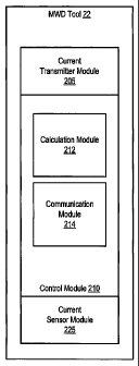
FIG. 2 is a block diagram of MWD tool 22. As shown, MWD tool 22 includes a
current
transmitter module 205, a control module 210, and a current sensor module 225.
MWD tool 22 can be
implemented as a sub (e.g., a drill collar) for use as part of a drillstring,
as described above. In one
CA 02689265 2012-12-31
WO 2008/151065 PCT/1JS2008/065397
6
embodiment, the structural features and physical components of MWD tool 22 are
similar to those
described in U.S. Patent No. 6,064,210, which issued on May 16, 2000 and names
Paul L. Sinclair as
inventor.
Current transmitter module 205 is configured to cause a current to be injected
into the subsurface
geologic formation surrounding a borehole in which MWD tool 22 is inserted. In
one embodiment,
current transmitter module is electrically and/or mechanically coupled to one
or more transmitters (not
shown) on the outside of MWD tool 22 by one or more contacts (e.g., spring
actuated contacts).
Current transmitter module 205 can include an oscillator (e.g., configured to
produce a sinusoidal
wave at a frequency in the range 100 Hz-10 KHz) as well as an associated power
amplifier configured to
boost the signal level of the output from the oscillator. In one embodiment,
the oscillator is a digital sine
wave synthesizer that also generates a synchronous square wave control signal
for a phase sensitive
detector included in current sensor module 225.
Current sensor module 225 is configured to quantify an amount of current
received by (or another
electrical characteristic detected at) each of several sensors disposed on the
outside of the MWD tool.
Like current transmitter module 205, current sensor module 225 can be
electrically and/or mechanically
coupled to each of several sensors by a contact (e.g., a spring actuated
contact). Current transmitter
module 205 and current sensor module 225, as well as their respective sensors,
transmitter(s), and
contacts, can be electrically insulated from each other.
Current transmitter module 205 and/or current sensor module 225 can also
include a sensor to
detect a formation voltage. For example, in one embodiment, current
transmitter module 205 includes an
external sensor coupled to internal circuitry for determining the formation
voltage. The voltage sensor
can be a monitor electrode that is electrically insulated from the transmitter
that injects current into the
formation. Information representing the magnitude of the formation voltage can
be provided to control
module 210.
As noted above, current transmitter module 205 is configured to inject current
into the formation
surrounding MWD tool 22 via one or more transmitters. The return path of the
current passes through the
sensors coupled to current sensor module 225. Based upon the proportion of the
amount of current
injected by current transmitter module 205 relative to the amount of current
received by each sensor
coupled to current sensor module 225, a calculation module 212 within control
module 210 can calculate
various formation characteristics, as described in more detail below.
In the illustrated example, control module 210 includes calculation module 212
and
communication module 214. Control module 210 is configured to receive
information from current
transmitter module 205 that indicates the amount of current injected into the
surrounding formation.
Control module 210 also receives information from current sensor module 225
that indicates the amount
of current received by each of several sensors.
CA 02689265 2009-11-27
WO 2008/151065 PCT/US2008/065397
7
Based on the information received by control module 210, calculation module
212 can process
the received information to calculate one or more values. In particular, based
upon the information
received from current sensor module 225, calculation module 212 can determine
whether the drill bit is
approaching an anomaly within the formation and, if so, calculate an azimuthal
angle describing the
location of the anomaly as well as a magnitude of a characteristic (e.g.,
conductivity or resistivity) of the
anomaly and a distance to the anomaly. More details regarding the types of
calculations that can be
performed by calculation module 212 are provided below in the discussions of
FIG. 3.
Communication module 214 is configured to communicate information received by
control
module 210 and/or calculated by calculation module 212 to another sub or to a
surface system.
Communication module 214 can be configured to interface to and/or communicate
via a wire line cable
(e.g., wire line cable 24 of FIG. 1), a telemetry system, or any other desired
communication system
and/or communication media.
In one embodiment, control module 210 (or a combination of control module 210
and current
transmitter module 205 and/or current sensor module 225) is implemented as an
inner cartridge that
includes all of the active components of MWD tool 22, including electronic
circuits, communication
circuits, directional sensors, and the like. In some embodiments, this inner
cartridge is retrievable, such
that the inner cartridge can be installed and/or withdrawn from MWD tool 22
while MWD tool 22 is
below the surface. For example, the inner cartridge can be installed or
withdrawn through the drillstring
using a slick line cable or wireline attached to the upper end of the MWD
tool. The drillstring can include
a muleshoe (not shown) to accept and orient the inner cartridge in such an
embodiment.
While certain components are shown as part of MWD tool in FIG. 2, it is noted
that in alternative
embodiments, such components can be implemented within other subs within the
drillstring and/or other
components within the drilling system. For example, the communication module
214 and/or directional
sensors (not shown) can each be implemented within another sub. Similarly, all
or part of the
functionality of control module 210 can be implemented within another sub or
within a surface
computing device.
FIG. 2A illustrates a cross-sectional view of MWD tool 22 (e.g., this cross
section can pass
through the section of the MWD tool that includes current sensor module 225).
This view illustrates how
sensors 230(1)-230(4) can be disposed around the outside of MWD tool 22. These
sensors can be
electrically and/or mechanically coupled to a sensor module within the MWD
tool. Sensors can include
electrodes, magnetic elements, or any other suitable device for detecting a
current flowing in (or other
electrical characteristic of) a formation surrounding the MWD tool.
In the example of FIG. 2A, four sensors 230(1)-230(4) are used. These sensors
are arranged in
pairs, such that within a given pair, the sensors are directly opposite of
each other. For example, sensor
230(2) is opposite sensor 230(3) (forming one pair of sensors), and sensor
230(1) is similarly opposite
sensor 230(4) (forming another pair). Furthermore, the sensors are evenly
spaced around the outside of
CA 02689265 2009-11-27
WO 2008/151065 PCT/US2008/065397
8
MWD tool 22, such that the sensors are each located 90 degrees apart on the
circumference of the MWD
tool 22.
It is noted that other sensor arrangements can be used in other embodiments.
For example,
instead of having the sensors be evenly spaced, some sensors can be slightly
closer to others (e.g., instead
of having sensors at 00, 90 , 180 , and 270 , sensors can be located at 00,
950, 180 , and 275'). Such an
arrangement can still allow sensors within a given pair of sensors to be
located directly opposite from
each other, if desired.
As yet another alternative, some sensors may be located in different planes
than other sensors.
For example, while the example of FIG. 2A shows all sensors as being located
in the same cross-sectional
plane of the MWD tool, other embodiments can arrange sensors so that some
sensors are located in a
plane somewhat (e.g., a few millimeters) above or below (e.g., relative to the
location of the end of the
MWD tool closest to the drill bit) the other sensors.
Furthermore, it is noted that other embodiments can include differing numbers
of sensors. For
example, one alternative embodiment can include six sensors around the
circumference of MWD tool 22.
Another alternative embodiment can include eight sensors. These sensors can be
evenly spaced around
the periphery of MWD tool 22, or the spacing can be varied as described above.
FIG. 2B is another cross-sectional view of MWD tool 22 illustrating another
sensor arrangement.
In this arrangement, only two sensors 230(1) and 230(2) are disposed around
the outside of MWD tool
22. In the illustrated example, the two sensors are located directly across
from each other in the same
plane. However, as described above, this arrangement can be varied (e.g., by
placing the sensors in
different planes or by moving one sensor so that the sensors are no longer
exactly opposite each other).
In embodiments such as the one shown in FIG. 2B, the MWD tool 22 can be
configured to take
multiple measurements, and to be rotated between each measurement in a series
of measurements. For
example, in order to obtain equivalent measurements to a MWD tool having four
pairs of sensors, the
MWD tool shown in FIG. 2B can take four measurements. Between each
measurement, the MWD tool is
rotated by 90 degrees. To take the equivalent measurements to a MWD tool
having two pairs of sensors,
the MWD tool can take two measurements while being rotated 180 degrees between
each measurement.
Similarly, a MWD tool having three sensors can be rotated one or more times to
take measurements
equivalent to those generated by a MWD tool having six, nine, or more sensors.
In general, depending
upon the number "n" of measurements desired, the MWD tool can be rotated
approximately 360/n
degrees between each measurement.
In some embodiments, the MWD tool is configured to provide measurements at a
fixed rate (e.g.,
one measurement every five minutes). In such embodiments, the MWD tool can be
slowly rotated
throughout the measurement process, such that the MWD tool is rotated the
desired number of degrees
between successive measurements. Thus, measurements can be taken while the MWD
tool is slowly
rotating (as opposed to being taken while the MWD is in a fixed, non-rotating
position).
CA 02689265 2009-11-27
WO 2008/151065 PCT/US2008/065397
9
FIG. 3 is a block diagram of functionality included within and/or coupled to
the MWD tool. In
particular, FIG. 3 illustrates an example of the functionality that can be
included within a calculation
module 212 of a MWD tool.
As shown, calculation module 212 includes conductivity values calculation
module 302, memory
310, azimuthal angle calculation module 320, formation property calculation
module 322, and graphics
module 330. Calculation module 212 is also coupled (e.g., via communication
module 214 of FIG. 2) to a
display device 340. It is noted that display device 340 is likely to be
located on the surface, where display
device 340 can be viewed by an operator.
Conductivity values calculation module 302 is configured to receive current
values from current
transmitter module 205 and/or current sensor module 225 of FIG. 2. These
values represent the amount of
current injected into the formation (as received from current transmitter
module 205) and the amount of
current returned to each of several sensors (as received from current sensor
module 225). It is noted that
in some embodiments, current transmitter module 205 always transmits the same
amount of current, and
thus a constant value representing that amount of current can be provided to
conductivity values
calculation module when the MWD tool is being configured, instead of having
the current transmitter
module dynamically provide such a value to calculation module 212 during
operation.
Conductivity values calculation module 302 can also receive one or more
voltage values (not
shown) that represent the formation voltage (e.g., the formation voltage can
be the voltage detected
between current transmitter module 205 and current sensor module 225). Such
voltage value(s) can be
received from current transmitter module 205 of FIG. 2
Conductivity values calculation module 302 can be configured to correct the
received current
values in order to account for any errors introduced by the measurement
process. For example, current
values can be corrected for any offset errors. The offset errors, if any, can
be detected and quantified by
switching calibrated signals in the inputs of the measurement circuits. The
voltage value, which
represents the formation voltage, can similarly be corrected for any errors.
Once conductivity values calculation module 302 has received and, if desired,
corrected the
received current and voltage values, conductivity values calculation module
302 can calculate the
individual apparent conductivity for each sensor, as well as a background
conductivity. To calculate the
individual apparent conductivity values, each individual current value is
divided by the formation voltage
value and multiplied by a tool constant.
For example, if there are four sensors in the MWD tool, calculation module 212
receives four
individual current values IA1, IA2, IA3, and IA4, which represent the current
received by respective
sensors Al, A2, A3, and A4, from current sensor module 225. In this example
configuration, which will
be referred to throughout the discussion of FIG. 3, sensors Al and A3 form one
pair and sensors A2 and
A4 form another pair. Sensors in the same pair are located substantially
opposite from each other (e.g.,
similar to the arrangement shown in FIG. 2A). Conductivity values calculation
module 302 can then
CA 02689265 2009-11-27
WO 2008/151065 PCT/US2008/065397
process these values to obtain a set of four apparent conductivity values:
GA1, GA2, GA3, and GA4. Each
apparent conductivity value is related to a corresponding sensor (e.g., crAl
relates to sensor Al, GA2
relates to sensor A2, and so on). It is noted that conductivity values
calculation module 302 can
alternatively (or additionally) calculate apparent resistivity values, which
will simply be the inverse of the
apparent conductivity values described herein.
Conductivity values calculation module 302 then calculates the background
conductivity, GAB.
If all of the sensors are receiving substantially the same amount of current,
conductivity values
calculation module 302 can calculate the background conductivity by averaging
the apparent conductivity
values. For example, in the situation in which there are four sensors, and
thus four apparent conductivity
values, the background conductivity can be calculated as:
aAl+A2+ CrA3 aA4
AB -
4
If some of the sensors are receiving different amounts of current, it
indicates that the drill bit may be
approaching an anomaly. In this situation, conductivity values calculation
module 302 can use the most-
recently calculated background conductivity as the current background
conductivity, instead of
calculating a new average.
After calculating the apparent conductivity values csA 1 -crAN (where N is the
number of sensors)
and the background conductivity GAB, conductivity values calculation module
302 can provide these
values to one or more other modules within calculation module 212. For
example, conductivity values
calculation module 302 can write these values to memory 310 as part of history
log 312.
In general, at any given time, history log 312 stores one or more sets of
apparent conductivities
(and/or resistivities) and/or one or more background conductivities (and/or
resistivities) that have been
previously calculated by conductivity values calculation module 302. History
log 312 can be configured
to store a maximum number of such sets of values (e.g., history log 312 can be
implemented as a circular
queue, such that once history log 312 is full, the newest entry to history log
312 will be written over the
oldest entry stored in history log 312).
Conductivity values calculation module 302 can also provide the apparent
conductivity values to
azimuthal angle calculation module 320. Azimuthal angle calculation module 320
is configured to
calculate an azimuthal angle, OA, from the apparent conductivity values. The
azimuthal angle describes
the location of an anomaly within a geographic formation (such an anomaly can
be a parallel bed of rock
that has different electrical characteristics than the rock formation
currently being encountered by the
drill bit) relative to a known point on the MWD tool. The azimuthal angle is
used to define a vector that
is perpendicular to the surface of the MWD tool and that describes the
direction in which the anomaly is
focused.
Azimuthal angle calculation module 320 makes determinations as to whether (1)
the apparent
CA 02689265 2009-11-27
WO 2008/151065 PCT/US2008/065397
11
conductivities indicate that the MWD tool is approaching an anomaly within the
formation and (2) if so,
whether the anomaly is more or less conductive than the surrounding formation.
Based on these
determinations, azimuthal angle calculation module 320 can then calculate the
azimuthal angle OA that
describes the location of the anomaly relative to a known point (e.g., a
prespecified one of the sensors) on
the MWD tool. Azimuthal angle calculation module 320 is configured to
calculate 0A by computing the
arctangent of the ratio of the differences between the apparent conductivities
(or resistivities) detected at
sensors in the same pair of sensors. As noted above, sensors within the same
pair are typically located on
substantially opposite sides of the MWD tool.
To determine whether the MWD tool (and thus the drill bet to which the MWD
tool is attached)
is approaching an anomaly, azimuthal angle calculation module 320 can perform
one or more
comparisons. For example, azimuthal angle calculation module 320 can compare
the individual apparent
conductivity values. If the values differ from each other, it can be an
indication that the formation is not
uniform. Alternatively (or additionally), azimuthal angle calculation module
320 can compare the most
recently received set of apparent conductivities (or resistivities) to
historical apparent conductivity values
stored in history log 312. If differences exist, it can indicate that the MWD
tool is approaching an
anomaly within the formation. If the apparent conductivities (or
resistivities) indicate that no anomaly is
present, azimuthal angle calculation module 320 does not need to calculate the
azimuthal angle.
If an anomaly is present, azimuthal angle calculation module 320 then
determines whether the
anomaly is more or less conductive than the surrounding formation. This
determination can be based on a
comparison of the most recently received set of apparent conductivities with
one or more historical
conductivities stored in history log 312. If any of the apparent
conductivities have increased relative to
the historical conductivities, azimuthal angle calculation module 320 can
determine that the MWD tool is
approaching a more conductive anomaly. Similarly, if any of the apparent
conductivities have decreased
relative to the historical conductivities, azimuthal angle calculation module
320 can determine that the
MWD tool is approaching a less conductive anomaly. It is noted that similar
determinations can be made
using resistivity instead of conductivity.
As an alternative to using history log 312, azimuthal angle calculation module
320 can attempt to
determine whether the anomaly is more or less conductive based solely on the
relative amount of current
currently being detected by each sensor. For example, in embodiments
configured with four sensors Al-
A4, azimuthal angle calculation module 320 (or another module, such as
conductivity values calculation
module 302) can identify the sensor Amin that is receiving the least amount of
current and the sensor
Amax that is receiving the greatest amount of current. If the anomaly is more
conductive than the
formation, then Amin is the nearest sensor and Amax is the furthest sensor,
while if the anomaly is more
resistive than the formation, Amax is the furthest sensor and Amin is the
nearest sensor. An example of
this situation is illustrated in FIG. 4.
CA 02689265 2009-11-27
WO 2008/151065
PCT/US2008/065397
12
FIG. 4 shows a cross-sectional view of the MWD tool passing through a
formation containing an
anomaly. In this example, borehole 12 (which contains the MWD tool) is passing
through formation 400.
An anomaly 405 within the formation is in close proximity to borehole 12 and
has a boundary that is
substantially parallel to the borehole axis.
In FIG. 4, the MWD tool is injecting current into formation 400, and the
returned current is
detected at each of four sensors. As shown, one sensor detects current 1, a
second sensor detects current
2, a third sensor detects current 3, and a fourth sensor detects current 4. If
anomaly 405 is more
conductive than formation 400, current 4 should be the greatest current (of
currents 1-4), and current 2
should be the minimum current. If instead anomaly is less conductive than
formation 400, current 4
should be the smallest current (again, of currents 1-4), and current 1 should
be the maximum current.
Returning to FIG. 3, once calculation module 212 has identified Amin and Amax,
the current
values received at the other sensors (i.e., the sensors that are not Amin nor
Amax) can be averaged to
produce an average current value Iavg. The ratios of the differences between
the maximum and minimum
currents and the average current can then be used to determine whether the
anomaly is more or less
conductive than the surrounding formation according to the following
observation:
Imax ¨I avg Imax ¨I avg
(for conductive anomaly) >> ___________________________________________ (for
resistive anomaly) .
I ¨
avg mm , Iavg ¨ Imin
In other words, the sensor nearest a conductive anomaly receives a far greater
percentage of the
total current than does the sensor farthest from a resistive anomaly.
Therefore, the conductive and
resistive anomaly cases can be distinguished, based upon the magnitude of the
ratio of the measured
sensor currents. The particular range of magnitudes to assign to conductive or
resistive anomalies can be
determined by performing computer simulations of the particular MWD tool being
used, and this range
may vary among different MWD tools.
It is noted that in some situations, the current values may not provide enough
information to
definitely determine whether the anomaly is more or less conductive than the
surrounding formation (e.g.,
if the anomaly is oriented directly between two sensors). In this situation,
historical information, such as
that stored in history log 312, can be used to decide whether the anomaly is
more or less conductive.
As noted briefly above, azimuthal angle calculation module 320 can calculate
the azimuthal
angle OA by calculating the arctangent of the difference in resistivity or
conductivity at each sensor of a
pair of sensors (e.g., pair 1 includes sensors Al and A3, and pair 2 includes
sensors A2 and A4). In an
embodiment in which the MWD tool has four sensors, azimuthal angle calculation
module 320 can
calculate the azimuthal angle OA using the following formulas. If the anomaly
is more conductive than
the surrounding formation, the azimuthal angle can be computed from the
apparent conductivity values,
as shown in the following formula:
CA 02689265 2009-11-27
WO 2008/151065 PCT/US2008/065397
13
GrAl -CI
A3
OA atan
\,aA2 -A4 )
If instead the anomaly is more resistive than the surrounding formation,
azimuthal angle
calculation module 320 can calculate the azimuthal angle using either the
apparent resistivity values pA 1
- pA4 or the apparent conductivity values:
( 1 1
P ¨ PA3 CFA1 CFA3
OA atan ___________ ¨ atan
1 1
PA2 PA4
0"A4
\ A2
The azimuthal angle calculated by the above formulas is calculated relative to
a known point
(i.e., the azimuthal angle is not calculated relative to whichever sensor is
currently closest to or furthest
from the anomaly). Accordingly, the resulting azimuthal angle describes the
location of the anomaly
relative to a known point (e.g., the location of one of the sensors). For
example, if the azimuthal angle is
calculated relative to the position of sensor Al, an azimuthal angle of 0
indicates that the anomaly is
located closest to sensor Al.
The output from a directional sensor included in and/or coupled to the MWD
tool can then be
used to determine the relationship between that known point and a standard
directional vector, such as
magnetic north or the gravity vector. The output from the directional sensor
can thus be provided to
azimuthal angle calculation module 320, which can use his information then
allows azimuthal angle
calculation module to calculate a relative azimuthal angle describing the
location of the anomaly relative
to the standard directional vector. This relative azimuthal angle can be
provided to graphics module 330,
as described in more detail below.
Formation property calculation module 322 calculates the magnitude of the
conductivity aA of
the anomaly. Together, the magnitude calculated by formation property
calculation module 322 and the
angle calculated by azimuthal angle calculation module 320 define a vector
quantity. It is noted that
instead of (or in addition to) calculating conductivity of the anomaly,
formation property calculation
module 322 can calculate resistivity of the anomaly.
Formation property calculation module 322 is configured to calculate the
conductivity csA based
upon the ratio, 'near-to-far, of current received at the sensor nearest to the
anomaly to current received at
the sensor farthest from the anomaly. Formation property calculation module
322 also uses the azimuthal
angle OA calculated by azimuthal angle calculation module 322, to obtain GA.
To be able to calculate Inear-to-far, formation property calculation module
322 first identifies
which of the sensors is nearest the anomaly. This sensor will be the near
sensor, and the other sensor
CA 02689265 2009-11-27
WO 2008/151065 PCT/US2008/065397
14
included in the same pair as the near sensor will be the far sensor. The
azimuthal angle OA, which (as
described above) is directly computed from the apparent conductivities at each
of the sensors by
azimuthal angle calculation module 320, can be used to identify which sensor
is nearest the anomaly,
since this angle is calculated relative to a fixed point on the MWD tool.
Accordingly, formation property
calculation module 322 can receive information specifying azimuthal angle OA
from azimuthal angle
calculation module 320 and use that information to identify the near and far
sensors. If two of the sensors
are equidistant from the anomaly (e.g., if OA = 45 , 135 , 225 , or 315 ),
either of the two closest sensors
may be designated as the near sensor, and the corresponding opposite sensor
can be designated as the far
sensor.
Once the near and far sensors have been identified, formation property
calculation module 322
can calculate the ratio Inear-to-far of current at the near sensor to current
at the far sensor. The calculation
uses the current values received by conductivity values calculation module 302
(alternatively,
conductivity values calculation module 302 can calculate Inear-to-far and
provide Inear-to-far to
formation property calculation module 322).
Formation property calculation module 322 then uses the information in lookup
table 314 to
calculate oA and a distance between the anomaly and the borehole. In one
embodiment, the information
in lookup table 314 is generated by simulating the MWD tool's response using a
finite element computer
model. For example, a three-dimensional finite element code model can be used
to determine the
response of a particular MWD tool to an anomaly that has a contrasting rock
resistivity relative to the
surrounding formation and that has a plane boundary parallel to the axis of
the MWD tool. During
modeling, the plane boundary is placed at different distances and azimuthal
angles relative to the MWD
tool. The resistivity (or conductivity) contrast between the anomaly and the
surrounding formation is also
altered. While these values are being varied, the voltages and currents
associated with each sensor on the
tool are computed. The results of the modeling correlate a particular
azimuthal angle and Inear-to-far
with one or more resistivities (or conductivities) as well as one or more
distances (here, each distance is
the distance between the boundary of the anomaly and the borehole).
Accordingly, formation property calculation module 322 can provide the
azimuthal angle and
near-to-far current ratio to lookup table 314 and obtain one or more
corresponding distances and one or
more corresponding formation property (e.g., resistivity or conductivity)
magnitudes. In one embodiment,
each lookup will return one or more distance and magnitude pairs, as described
in more detail below. In
some situations, an exact match may not be found in lookup table 314, and thus
formation property
calculation module 322 may need to interpolate between the values in two
adjacent entries of lookup
table 314. Alternatively, the information stored in lookup table 314 can be
represented by a set of
mathematical functions, and formation property calculation module 322 can use
curve-fitting techniques
to obtain the magnitude and distance values based upon those functions.
It is noted that due to ambiguities, several magnitude and distance pairs can
correspond to the
CA 02689265 2009-11-27
WO 2008/151065 PCT/US2008/065397
same near-to-far current ratio and azimuthal angle pair. For example, the same
near-to-far current ratio
and azimuthal angle pair can correspond to both a more conductive anomaly
located further from the
MWD tool and a less conductive anomaly located closer to the MWD tool. Absent
additional information
to determine which of these potential anomaly characteristic pairs is the
correct characteristic pair, the
MWD tool can simply provide all possible characteristic pairs and graphics
module 330 can display each
possible characteristic of the anomaly to an operator.
As an example of how the information in lookup table 314 can be calculated and
used, in one
embodiment, finite element simulations can be performed for three different
azimuthal angles, eight
different values of anomaly resistivity, and 12 different anomaly-to-borehole
distances, resulting in a total
of 288 simulation scenarios. The resulting information can be saved to lookup
table 314 as a sequence of
288 near-to-far current ratios, and these ratios can be arranged in three main
groups. The first group of 96
values corresponds to simulations in which the azimuthal angle is 0 , the next
96 values correspond to
simulations in which the azimuthal angle is 22.5 , and the final 96 values
correspond to simulations in
which the azimuthal angle is 45 . Each group of 96 values includes eight
subgroups. Each subgroup
corresponds to one of the eight resistivity values, and these subgroups can be
arranged in increasing order
of resistivity. The 12 values in each subgroup correspond to the 12 anomaly-to-
borehole distances for
which the simulations were performed, arranged in order of increasing
distance.
To use this information, formation property calculation module 322 first
selects two of the three
azimuthal angles for which the finite element model was solved. The two angles
are selected such that the
range bounded by the two angles contains the azimuthal angle calculated by
azimuthal angle calculation
module 320. For example, if the azimuthal angle is 15 , formation property
calculation module 322 can
select 01 = 0 and 02= 22.5 . Formation property calculation module 322 can
then obtain information
identifying a set of distances and corresponding near-to-far current ratios
for each of the selected angles
from lookup table 314.
Since the selected angles are not equal to the calculated azimuthal angle,
formation property
calculation module 322 can then use interpolation to generate an interpolated
set of distances and
corresponding near-to-far current ratios, based upon the set of information
obtained from lookup table
314. For example, assume that lookup table 314 indicates that for 01 = 0 and
02 = 22.5 , the following
distances correlate to the near-to-far current ratios listed in the same
column, for an anomaly having a
resistivity of 0.2 f-m:
distance 0.0830m 0.1016m 0.1524m 0.2032m
near-to-far ratio (00) 27.571788 5.836751 2.653185 1.975069
near-to-far ratio (22.5 ) 22.758449 5.054004 2.437898 1.876372
Based upon this information, formation property calculation module 322 can
calculate an array of
near-to-far current values versus distance for the measured azimuthal angle of
15 by interpolating
CA 02689265 2009-11-27
WO 2008/151065 PCT/US2008/065397
16
between the corresponding points in the two arrays of finite element data
corresponding to 01 = 00 and
02 = 22.5 .
distance 0.0830m 0.1016m 0.1524m 0.2032m
near-to-far ratio (15 ) 24.362895 5.314919 2.509660 1.909271
Now, formation property calculation module 322 can use the interpolated data
along with the
near-to-far current ratio to obtain an estimate of the distance to a 0.2 KI-m
anomaly. If an exact match for
the calculated near-to-far current ratio is not present in the lookup table,
formation property calculation
module 322 can select two values of the near-to-far ratio from the
interpolated data, such that the selected
values define a range that includes the measured near-to-far current ratio.
For example, if the measured
near-to-far current ratio is 3.0, formation property calculation module 322
can select near-to-far ratio
values 5.314919 and 2.509660, which correspond to distances of 0.1016 meters
and 0.1524 meters,
respectively. Interpolating between the corresponding distance values,
formation property calculation
module 322 obtains a distance estimate of 0.143521 meters, or about 5.65".
Accordingly, based on the
information obtained from lookup table 314, the near-to-far current ratio (3.0
in this example) and
azimuthal angle measured by the MWD tool is consistent with a 0.2 CI-m
parallel bed at a distance of
5.65".
As mentioned above, multiple distance and magnitude pairs can correspond to
the same near-to-
far current ratio and azimuthal angle. Thus, formation property calculation
module 322 can repeat the
process described above for one or more other anomaly resistivity values
specified in lookup table 314.
Each magnitude and distance pair obtained by formation property calculation
module 322 can be
provided to graphics module 330.
Thus, as the above example shows, formation property calculation module 322
can use
information (such as the information stored in lookup table 314 of FIG. 3)
generated by modeling to
identify one or more distances and one or more resistivities or conductivities
(or other magnitudes of
formation characteristics) of the anomaly, based upon the current ratio Inear-
to-far and azimuthal angle
OA. If needed, formation property calculation module 322 can interpolate
between known values to
obtain these distances and magnitudes.
Graphics module 330 is configured to receive values calculated by conductivity
values
calculation module 302, azimuthal angle calculation module 320, and formation
property calculation
module 322. Based upon these values, graphics module 330 is configured to
generate information to be
displayed to a user on display device 340. In some embodiments, this
information is primarily textual.
In other embodiments, graphics module 330 is configured to generate one or
more graphics that
represent one or more of the quantities received from the other modules. For
example, in one
embodiment, graphics module 330 is configured to generate a polar display that
includes graphical
content representing the anomaly that is being characterized by the values
provided to graphics module
CA 02689265 2009-11-27
WO 2008/151065 PCT/US2008/065397
17
330. The graphical content can be displayed upon a polar display, in which the
center of the polar display
corresponds to a location of a borehole in which the MWD tool is located.
In such an embodiment, graphics module 330 can be configured to generate
information defining
one or more regions, each of which represents a possible position of the
anomaly relative to the borehole
and magnitude (in terms of conductivity, resistivity, or another formation
characteristic) of the anomaly.
The different regions can be distinguished by using different colors and/or
shading patterns to fill and/or
outline each region.
As noted above, lookup table 314 can provide one or more magnitudes and
distances to
formation property calculation module 322. A region can be generated for each
magnitude and distance
pair, and thus multiple regions can be displayed on the polar display. The
number of regions to display
will depend upon the distance between each region and the borehole and the
resolution of the polar
display.
In one embodiment, graphics module 330 generates the boundary of each region
by identifying a
tangent line. The tangent line is calculated based upon the azimuthal angle
and the distance component of
the magnitude and distance pair to be represented by that region. The tangent
line intersects a circle
(centered at the center of the polar display) that has a radius equal to the
distance component. This
tangent line can then be used as the boundary of the region. Specific
equations that graphics module 330
can implement to generate the tangent line are described below with respect to
FIG. 5, which illustrates
graphical content that can be generated by graphics module 330.
The magnitude component of the magnitude and distance pair to be represented
by that region is
used to determine how to shade that region. For example, a key or legend that
correlates different
conductivities or resistivities to particular color and/or shading schemes can
be displayed as part of the
graphic. Based upon the magnitude that corresponds to a particular region,
graphics module 330 can
select the appropriate color and/or shading scheme and fill the region with
the selected color and/or
shading scheme.
While specific equations have been described in the above description of FIG.
3, it is noted that
other embodiments can implement different equations. For example, a MWD tool
having six sensors will
use different equations than those presented above, which are designed for use
with a MWD tool having
four sensors. Similarly, in alternative embodiments, graphics module 330 can
use different equations to
calculate the boundaries of the regions to be displayed.
While FIG. 3 shows a particular set of modules as being part of calculation
module 212, it is
noted that at least some of this functionality (e.g., such as the
functionality implemented by graphics
module 330) can alternatively be implemented outside of the MWD tool. For
example, in one alternative
embodiment, calculation module 212 can include only conductivity values
calculation module 302, while
a surface device (e.g., a surface computer system) can implement the other
functionality shown in FIG. 3.
In particular, the surface device can implement (e.g., in software executing
on a computing device)
CA 02689265 2009-11-27
WO 2008/151065 PCT/US2008/065397
18
azimuthal angle calculation module 320, formation property calculation module
322, graphics module
330, history log 312, and lookup table 314. The MWD tool can communicate the
conductivity values
generated by conductivity values calculation module 302 to the surface device,
which can then operate as
described above.
As another alternative, the MWD tool can calculate the individual apparent
conductivity (or
resistivity) values and provide the values to a surface device, which can then
calculate background
conductivity oAB, near-to-far current ratio Inear-to-far, azimuthal angle OA,
and anomaly conductivity
(TA and distance.
As yet another alternative, the surface device can implement graphics module
330 instead of
calculation module 212. Thus, the MWD tool can provide the values generated by
conductivity values
calculation module 302, azimuthal angle calculation module 320, and formation
property calculation
module 322 to the surface device, which can then input the values to graphics
module 330. Many other
alternative implementations, which can subdivide the functionality shown in
FIG. 3 between the MWD
tool and a surface computing device in a variety of different ways, are also
possible.
FIG. 5 is a block diagram of a polar display generated by and/or using
information provided by
the MWD tool. FIG. 5 illustrates how graphical content (e.g., as generated by
graphics module 330 of
FIG. 3) can be displayed on a polar display 550. In this example, various
resistivity values are associated
with different shades of grey, as shown in a key 500. In key 500, darker
shades of grey (towards the top
of the key) represent regions of increasing resistivity.
Polar display 550 includes a center portion 555, which represents the
borehole. Polar display 550
also includes several concentric rings 560, which represent various distances,
labeled 5, 10, 15, 20, and
25 (e.g., specifying distance in meters, feet, or inches), from the borehole.
The majority of the display is shaded with shade 565. This pattern represents
the resistivity of the
formation through which the borehole is currently passing (e.g., this
resistivity can be determined by
taking the inverse of the background conductivity generated by conductivity
values calculation module
302 of FIG. 3).
Two regions 570 and 575 of different resistivity are also shown on the
display. Region 570 is
shaded using shade 580 and region 575 is shaded using shade 585. Each of these
regions is shown as
being located at a different radial distance from the center of the polar
display. The angular direction of
the regions indicates the direction of the anomaly relative to magnetic north
(when drilling a substantially
vertical well) or the gravity vector (when drilling a substantially horizontal
well). Each region 570 and
575 can correspond to a magnitude and distance pair calculated by formation
property calculation module
322 of FIG. 3. Thus, both regions represent possible characteristics of the
anomaly.
Based upon the polar display, an operator is able to determine the direction
and proximity of an
adjacent anomaly. As noted above, there may be several potential ways to
characterize the anomaly
CA 02689265 2009-11-27
WO 2008/151065 PCT/US2008/065397
19
(using multiple magnitude and distance pairs, as described above), since the
MWD tool can respond in
the same way to highly conductive bed at a greater distance as to a less
conductive bed at close
proximity. Thus, multiple possible characterizations of the anomaly can be
displayed on the polar display,
as indicated by the two regions displayed in FIG. 5.
In some embodiments, information about the anomalies already encountered by
the borehole can
be stored as part of the logging history. The graphics module can access this
logging history and, in some
situations, use the logging history to select fewer than all of the regions to
display (e.g., if the logging
history indicates that the anomaly has a particular resistivity, only the
region having that resistivity needs
to be displayed).
To generate regions such as 570 and 575 for display on a polar display, a
graphics module (e.g.,
such as graphics module 330 of FIG. 3) can calculate a tangent line. For a
given region, the tangent line
will identify the boundary of that region that is closest to the center of the
polar display. Line 595 is an
example of a tangent line for region 570.
The tangent line intercepts one of the concentric circles at a point having
coordinates x =
y = R=cose, where R is the distance associated with the region and 0 is the
relative azimuthal
angle associated with the anomaly. The tangent line also intersects the y-axis
of the polar display at a
point where x = 0, y = R/cos0. Accordingly, the equation of the tangent line
is:
_ R¨x -sin
Y¨ cos 0 =
Since only a portion of the tangent line will be displayed, the graphics
module can truncate the tangent
line, such that:
x2 + y2 < R2
Thus, a graphics module can calculate a tangent line that defines the boundary
of a region
corresponding to a particular possible characteristic (as defined by a
magnitude distance pair) of an
anomaly. If there is room on the display to show multiple such regions,
additional tangent lines can be
calculated and used to define the boundaries of the other regions.
FIG. 6 is a flowchart of a method of calculating information describing a
formation property.
This method can be performed by a MWD tool and/or a surface computing device,
as described above. In
one embodiment, operation 600 is performed by a MWD tool and operations 610,
620, 630, and 640 are
performed by a surface computing device. In other embodiments, operations 600,
610, 620, and 630 are
performed by a MWD tool and operation 640 is performed by a surface computing
device.
The method begins at 600, when the MWD tool identifies an electrical
characteristic (e.g.,
current and/or voltage) at each of several sensors included as part of the MWD
tool. Based upon the
identified characteristics, a near-to-far ratio is calculated, which indicates
the ratio of the electrical
CA 02689265 2009-11-27
WO 2008/151065 PCT/US2008/065397
characteristic detected at the sensor nearest to an anomaly relative to the
electrical characteristic detected
at the sensor furthest from the anomaly, as shown at 610. Techniques for
identifying the near and far
sensors are described above in the description of FIG. 3.
At 620, an azimuthal angle is calculated, based upon the electrical
characteristics detected at the
sensors. The azimuthal angle can be calculated, for example, by determining
the apparent conductivity of
a formation at each of the sensors, using the individual electrical
characteristic identified by each of the
sensors, and then using the apparent conductivities to calculate the azimuthal
angle.
At 630, one or more distances and magnitudes are obtained from a lookup table,
based upon the
near-to-far ratio and the azimuthal angle. Information identifying the
azimuthal angle, distance, and
magnitude can then be provided to a user, as shown at 640. This information
can be provided in the form
of a graphical display.
FIG. 7 is a flowchart of a method of generating such a display. This method
can be performed by
a graphics module (e.g., graphics module 330 of FIG. 3). The method begins at
700, when the graphics
module calculates a tangent line, based upon the azimuthal angle and distance
calculated in FIG. 6.
The graphics module then calculates graphical information defining a region
that is bordered by
the tangent line, as shown at 710. This graphical information can be based
upon the tangent line as well
as the magnitude calculated in FIG. 6. The graphical information can include
information specifying the
location of the region on a polar display (e.g., such that the region is
bounded by the tangent line) as well
as a type of shading (e.g., in terms of color and/or pattern) with which to
fill the region (e.g., the shading
can indicate the magnitude of the electrical characteristic to which the
region corresponds).
If there are more regions to be displayed, as determined at 720, operations
700 and 710 can be
repeated for each additional region. Once all of the graphical information for
each region has been
calculated, the regions are rendered on a polar display, as shown at 730.
FIG. 8 is a simplified graph that shows the relationship between the distance
to the boundary of a
parallel anomaly and the resistivity contrast detected by the MWD tool. It is
noted that the data used to
generate a graph can be obtained by performing a computer simulation of a
model of the MWD tool, as
noted above in the discussion of FIG. 3.
The graph of FIG. 8 suggests a simple inverse-square-law relation between a
normalized current
difference Inorm (defined below) and the distance from the boundary. In FIG.
8, the normalized current
ratio is plotted against the bed distance, along with a computed inverse-power-
law curvefit, showing the
close correlation between the two curves.
Finite element modeling of (or other simulation of) a MWD tool can predict the
current
distribution, as sensed by the MWD tool, that will arise from a given
formation-anomaly combination,
based on the specific geometric relationship and electrical characteristics of
the formation and the
anomaly. As discussed above, one type of anomaly is a parallel bed (a planar
region parallel to the
CA 02689265 2009-11-27
WO 2008/151065 PCT/US2008/065397
21
borehole), which can have a resistivity that is markedly higher or lower than
that of the adjacent
formation. As previously discussed, if the resistivity of a parallel bed is
lower than that of the formation,
then the sensor nearest the parallel bed will receive more current than the
sensor on the opposite side of
the MWD tool (i.e., the sensor farthest from the parallel bed). On the other
hand, if the resistivity of the
parallel bed is higher than that of the formation, the exact opposite holds,
such that the nearest sensor
receives less current than the sensor farthest from the bed.
Additionally, a further observation can be made regarding the relationship
between the
"normalized" near-to-far current ratio 'norm and the distance to the parallel
bed. The normalized
near-to-far current ratio (for a conductive parallel bed) as follows:
'near 'far
Inorm =
I far
As shown in FIG. 8, this ratio closely follows a simple inverse-power-law
relationship as a
function of the distance from the borehole to the conductive parallel bed.
This can be seen in the graph,
which plots Inorm versus distance for a resistivity contrast of pcontrast =
0.0002, and typical of pcontrast
<1.0).
Returning to FIG. 3, it is noted that all or some of the modules 212, 302,
320, 322, and 330
shown in FIG. 3 can be implemented in software executing on a computing device
(e.g., a personal
computer, server, personal digital assistant, cell phone, laptop, workstation,
or the like). In particular,
such a computing device includes one or more processors (e.g.,
microprocessors, PLDs (Programmable
Logic Devices), or ASICs (Application Specific Integrated Circuits))
configured to execute program
instructions stored in a memory (e.g., such as memory 310 of FIG. 3). Such a
memory can include
various types of RAM (Random Access Memory), ROM (Read Only Memory), Flash
memory, MEMS
(Micro Electro-Mechanical Systems) memory, and the like. The computing device
can also include one
or more interfaces (e.g., such as network interfaces, one or more interfaces
to storage devices, and/or one
or more interfaces to an input / output (I/O) device such as a keyboard,
digital tablet, mouse, monitor, or
the like), which can each be coupled (e.g., by a bus or other interconnect) to
the processor(s) and
memory.
It is noted that the program instructions and data (e.g., such as history log
312 and/or lookup
table 314) implementing all or part of calculation module 212 can be stored on
various computer readable
media such as memory 310. In some embodiments, such program instructions can
be stored on a
computer readable storage medium such as a CD (Compact Disc), DVD (Digital
Versatile Disc), hard
disk, optical disk, tape device, floppy disk, and the like. In order to be
executed by a processor, the
instructions and data are loaded into memory from the other computer readable
storage medium. The
instructions and/or data can also be transferred to a computing device for
storage in memory via a
network such as the Internet or upon a carrier medium.
CA 02689265 2009-11-27
WO 2008/151065 PCT/US2008/065397
22
Although the present invention has been described in connection with several
embodiments, the
invention is not intended to be limited to the specific forms set forth
herein. On the contrary, the present
invention is intended to cover such alternatives, modifications, and
equivalents as can be reasonably
included within the scope of the invention as defined by the appended claims.
INDUSTRIAL APPLICABILITY
Embodiments of the present invention can be used in the field of natural
resource exploration,
discovery, and/or extraction.