Note: Descriptions are shown in the official language in which they were submitted.
CA 02727038 2010-12-06
WO 2009/149417 PCT/US2009/046504
METHOD AND SYSTEM FOR DETERMINING LOCATION USING A HYBRID
SATELLITE AND WLAN POSITIONING SYSTEM BY SELECTING THE BEST
WLAN-PS SOLUTION
CROSS-REFERENCE TO RELATED APPLICATIONS
[0001] This application claims the benefit under 35 U.S.C. 119(e) of U.S.
Provisional Application No. 61/059,580, filed on June 6, 2008, entitled
Integrated WLAN-
based and Satellite-based Positioning System, which is herein incorporated by
reference
in its entirety.
[0002] This application is related to the following references:
U.S. Patent Application Ser. No. (TBA), filed concurrently herewith and
entitled "Systems and methods for Using Environmental Information in a Hybrid
Positioning System;"
U.S. Patent Application Ser. No. (TBA), filed concurrently herewith and
entitled "Systems and Methods for Maintaining Clock Bias Accuracy in a Hybrid
Positioning System;"
U.S. Patent Application Ser. No. (TBA), filed concurrently herewith and
entitled "System and Method for Refining a WLAN-PS Estimated Location Using
Satellite
Measurements in a Hybrid Positioning System;"
U.S. Patent Application Ser. No. (TBA), filed concurrently herewith and
entitled "Method and System for Determining Position Using a WLAN-PS Estimated
Position as an Initial Position in a Hybrid Positioning System;"
U.S. Patent Application Ser. No. (TBA), filed concurrently herewith and
entitled "Methods and Systems for Improving the Accuracy of Expected Error
Estimation
in a Hybrid Positioning System;"
U.S. Patent Application Ser. No. (TBA), filed concurrently herewith and
entitled "Methods and Systems for Stationary User Detection in a Hybrid
Positioning
System;" and
U.S. Patent Application Ser. No. (TBA), filed concurrently herewith and
entitled "System and Method for Using a Satellite Positioning System to Filter
WLAN
Access Points in a Hybrid Positioning System."
-1-
CA 02727038 2010-12-06
WO 2009/149417 PCT/US2009/046504
BACKGROUND
Field
[0003] The disclosure generally relates to hybrid positioning systems and,
more
specifically, to methods of integrating wireless local area network (WLAN)-
based
positioning system (WLAN-PS) and satellite-based positioning system (SPS) to
improve
accuracy of location estimates, increase availability of the positioning
service to more
users, reduce power consumption, and also to improve estimation of the
expected error in
a user's position estimate.
Description of Related Art
[0004] In recent years the number of mobile computing devices has increased
dramatically, creating the need for more advanced mobile and wireless
services. Mobile
email, walkie-talkie services, multi-player gaming, and call-following are
examples of
how new applications are emerging for mobile devices. In addition, users are
beginning
to demand/seek applications that not only utilize their current location but
also share that
location information with others. Parents wish to keep track of their
children, supervisors
need to track the locations of the company's delivery vehicles, and a business
traveler
looks to find the nearest pharmacy to pick up a prescription. All of these
examples
require an individual to know his own current location or the location of
someone else.
To date, we all rely on asking for directions, calling someone to ask their
whereabouts or
having workers check-in from time to time to report their positions.
[0005] Location-based services are an emerging area of mobile applications
that
leverage the ability of new devices to calculate their current geographic
positions and
report them to a user or to a service. Examples of these services range from
obtaining
local weather, traffic updates, and driving directions to child trackers,
buddy finders, and
urban concierge services. These new location-sensitive devices rely on a
variety of
technologies that all use the same general concept. By measuring radio signals
originating from known reference points, these devices can mathematically
calculate the
user's position relative to these reference points. Each of these approaches
has its
strengths and weaknesses, depending upon the nature of the signals and
measurements,
and the positioning algorithms employed.
-2-
CA 02727038 2010-12-06
WO 2009/149417 PCT/US2009/046504
[0006] The Navstar Global Positioning System (GPS) operated by the US
Government leverages about two-dozen orbiting satellites in medium-earth
orbits as
reference points. A user equipped with a GPS receiver can estimate his three-
dimensional
position (latitude, longitude, and altitude) anywhere at any time within
several meters of
the true location, as long as the receiver can see enough of the sky to have
four or more
satellites "in view." Cellular carriers have used signals originating from and
received at
cell towers to determine a user's or a mobile device's location. Assisted GPS
(AGPS) is
another model that combines both GPS and cellular tower techniques to estimate
the
locations of mobile users who may be indoors and must cope with attenuation of
GPS
signals on account of sky blockage. In this model, the cellular network
attempts to help a
GPS receiver improve its signal reception by transmitting information about
the satellite
positions, their clock offsets, a precise estimate of the current time, and a
rough location
of the user based on the location of cell towers. No distinction is made in
what follows
between GPS and AGPS.
[0007] All positioning systems using satellites as reference points are
referred to
herein as Satellite-based Positioning System (SPS). While GPS is the only
operational
SPS at this writing, other systems are under development or in planning. A
Russian
system called GLONASS and a European system called Galileo may become
operational
in the next few years. All such systems are referred to herein as SPS. GPS,
GLONASS
and Galileo are all based on the same basic idea of trilateration, i.e.,
estimating a position
on the basis of measurements of ranges to the satellites whose positions are
known. In
each case, the satellites transmit the values of certain parameters which
allow the receiver
to compute the satellite position at a specific instant. The ranges to
satellites from a
receiver are measured in terms of the transit times of the signals. These
range
measurements can contain a common bias due to the lack of synchronization
between the
satellite and receiver (user device) clocks, and are referred to as
pseudoranges. The lack
of synchronization between the satellite clock and the receiver (user device)
clock results
in a difference between the receiver clock and the satellite clock, which is
referred to as
internal SPS receiver clock bias or receiver clock bias, here. In order to
estimate a three
dimensional position there is a need for four satellites to estimate receiver
clock bias
along with three dimensional measurements. Additional measurements from each
satellite correspond to pseudorange rates in the form of Doppler frequency.
References
-3-
CA 02727038 2010-12-06
WO 2009/149417 PCT/US2009/046504
below to raw SPS measurements are intended generally to mean pseudoranges and
Doppler frequency measurements. References to SPS data are intended generally
to
mean data broadcast by the satellites. References to an SPS equation are
intended to
mean a mathematical equation relating the measurements and data from a
satellite to the
position and velocity of an SPS receiver.
[0008] WLAN-based positioning is a technology which uses WLAN access points to
determine the location of mobile users. Metro-wide WLAN-based positioning
systems
have been explored by a several research labs. The most important research
efforts in this
area have been conducted by the PlaceLab (www.placelab.com, a project
sponsored by
Microsoft and Intel); the University of California, San Diego ActiveCampus
project
(ActiveCampus - Sustaining Educational Communities through Mobile Technology,
technical report #CS2002-0714); and the MIT campus-wide location system. There
is
only one commercial metropolitan WLAN-based positioning system in the market
at the
time of this writing, and it is referred to herein as the WPS (WiFi
positioning system)
product of Skyhook Wireless, Inc. (www.skyhookwireless.com).
[0009] Figure 1 depicts a conventional WLAN-based positioning system based on
WiFi signals. The positioning system includes positioning software 103 that
resides on a
mobile or user device 101. Throughout a particular target geographical area,
there are a
plurality of fixed wireless access points 102 that transmit information using
control/common channel signals. The device 101 monitors these transmissions.
Each
access point contains a unique hardware identifier known as a MAC address. The
client
positioning software 103 receives transmissions from the 802.11 access points
in its range
and calculates the geographic location of the computing device using the
characteristics
of the radio signals. Those characteristics include the MAC addresses, the
unique
identifiers of the 802.11 access points, the Time of Arrival (TOA) of the
signals, and the
signal strength at the client device 101. The client software 103 compares the
observed
802.11 access points with those in its reference database 104 of access
points. This
reference database 104 may or may not reside in the device 101. The reference
database
104 contains the calculated geographic locations and power profiles of all
access points
the system has collected. A power profile may be generated from a collection
of
measurements of the signal power or signal TOA at various locations. Using
these
known locations or power profiles, the client software 103 calculates the
position of the
-4-
CA 02727038 2010-12-06
WO 2009/149417 PCT/US2009/046504
user device 101 relative to the known positions of the access points 102 and
determines
the device's 101 absolute geographic coordinates in the form of latitude and
longitude or
latitude, longitude, and altitude. These readings then can be fed to location-
based
applications such as friend finders, local search web sites, fleet management
systems, and
an E91 l service.
[0010] In the discussion herein, raw WLAN measurements from an access point
are
generally intended to mean received signal strength (RSS) and/or times of
arrival (TOAs)
and/or time differences of arrival (TDOAs). References to data are generally
intended to
mean the MAC address, one or more record(s) of it, one or more power
profile(s), and
other attributes based on previous measurements of that access point.
References to a
WLAN-PS equation are intended to mean a mathematical equation relating the
WLAN-
PS measurements and data to the location of the mobile device.
[0011] A WLAN-based positioning systems can be used indoor or outdoor. The
only
requirement is presence of WLAN access points in the vicinity of the user. The
WLAN-
based position systems can be leveraged using existing off-the-shelf WLAN
cards
without any modification other than to employ logic to estimate position.
[0012] Figure 2 illustrates a conventional way of integrating WLAN-PS and SPS,
which consists of a WLAN-PS 201 and a SPS 206, and a location combining logic
210.
[0013] WLAN-PS 201 and SPS 206 are stand-alone systems and each can operate
independently of the other system. Thus the result of each system can be
calculated
independent of the other system. The estimated location along with the
expected error
estimation of each system can be fed to the location combining logic 210. The
expected
error estimation is also referred to as HPE (horizontal positioning error)
herein. The
nominal rate of location update of SPS 206 and WLAN-PS 201 is once a second.
The
location combining logic 210 combines location estimates calculated in the
same second
by both systems.
[0014] WLAN-PS 201 is a conventional system which estimates the location of a
mobile device by using WLAN access points. WLAN-PS 201 can include a scanner
of
WLAN APs 202, a device to select WLAN APs 203, a trilateration module 204, and
HPE
estimation device 205.
[0015] WLAN Scanner 202 detects WLAN APs surrounding the mobile device by
detecting the received power (RSS, received signal strength) and/or time of
arrival (TOA)
-5-
CA 02727038 2010-12-06
WO 2009/149417 PCT/US2009/046504
of the signal. Different methods can be used to detect WLAN APs including
active
scanning, passive scanning, or combination of passive and active scanning.
[0016] The select WLAN APs device 203 selects the best set of WLAN APs to
estimate location of the mobile device. For example, if ten WLAN APs are
detected and
one AP is located in Chicago and the others are located in Boston, without any
other
information, the Boston APs are selected. This is an indication that Chicago
AP has been
moved to Boston. In the conventional system the best set of WLAN APs is
selected based
on geographical distribution of WLAN APs in addition to corresponding
parameters of
WLAN APs, including received signal strength, signal to noise ration, and the
probability
of being moved.
[0017] Trilateration module 204 uses WLAN APs and corresponding measurements
and characteristics to estimate location of the mobile device. Received signal
strength or
TOA measurements from WLAN AP are used to estimate distance of the mobile
device
to the WLAN AP. The aggregation of distance estimates from different WLAN APs
with
known location is used to calculate location of the mobile device.
Trilateration 204 also
can use a method which is called nearest neighbor, in which a location with a
power
profile similar or closest to the power reading of the mobile device is
reported as the final
location of the mobile device. The power profile of each WLAN AP or entire
coverage
area can be found in the calibration phase of the system by detailed survey of
the
coverage area.
[0018] HPE estimation device 205 is the module which estimates the expected
error
of the position estimate of the mobile device. The HPE, or Horizontal
Positioning Error
is calculated based on previously scanned APs and their characteristics and
also
characteristics of the received signal, as it was explained in co-pending
Skyhook Wireless
Application No. 11/625,450 entitled "System and Method for Estimating
Positioning
Error Within a WLAN Based Positioning System," the entire disclosure of which
is
hereby incorporated by reference.
[0019] SPS system 206 consists of a satellite signal receiver and measurement
device
207, trilateration device 208, and the SPS HPE estimation module 209.
[0020] The satellite signal receiver and measurement device 207 receives
signals
from the satellites in view of the device, decodes the received signal, and
measures the
-6-
CA 02727038 2010-12-06
WO 2009/149417 PCT/US2009/046504
satellite parameters from each satellite. The measurements can include
pseudorange,
carrier frequency, and Doppler frequency.
[0021] The trilateration device 208 uses measurements from at least four
satellites
and location of the satellites in view to estimate location of the user
device, velocity, and
direction of travel of the mobile device.
[0022] HPE estimation device 209 estimates the expected error of the estimated
location. The HPE estimation device 209 is conventional and calculates
expected error
based on geometry of the satellites and signal quality of the received signal
from
satellites, for example, DOP (dilution of precision), and C/N (carrier to
noise ratio).
[0023] Location combining logic 210 receives location and HPE estimates
calculated
for almost the same second from WLAN-PS 201 and SPS 206. In other words,
measurements and estimations which are made at the same time are compared and
combined. Practically, measurements and estimations within one second can be
considered the same time. The location combining logic 210 of the user device
reports
one estimated location by selecting one of them or linearly combining them.
For
example, location combining logic might select one of the estimated locations
provided
by WLAN-PS 201 or SPS 206 based on reported expected error or HPE, or it might
report weighted average of estimated locations by both systems according to
the HPE.
SUMMARY
[0024] This disclosure describes a method and system for determining location
using a hybrid satellite and WLAN positioning system by selecting the best
WLAN-PS
solution. In some embodiments, the method of increasing the accuracy of a WLAN
based position estimate using satellite positioning information can include
determining a
set of possible WLAN location solutions for a WLAN and satellite enabled
device based
on one or more WLAN access points, obtaining satellite information for the
WLAN and
satellite enabled device from at least two different satellites, and using the
satellite
information from the at least two different satellites to determine the best
WLAN location
solution from the set of possible WLAN location solutions.
[0025] In some embodiments, using the satellite information from the at least
two
different satellites to determine the best WLAN location solution from the set
of possible
-7-
CA 02727038 2010-12-06
WO 2009/149417 PCT/US2009/046504
WLAN location solutions can include examining each of the possible WLAN
location
solutions against the satellite information and selecting the location based
on which of the
possible WLAN position locations satisfies the satellite information.
[0026] In some embodiments, the step of using the satellite position
information
from the at least two different satellites to determine the best WLAN location
solution
from the set of possible WLAN location solutions can include eliminating
possible
WLAN location solutions which are not consistent with the satellite
information.
[0027] In some embodiments, the WLAN location solution consistency with the
satellite information can be measured by applying each of the possible WLAN
based
position estimates to the satellite measurements and calculating the internal
SPS receiver
clock bias for each possible WLAN based position estimate.
[0028] In some embodiments, the consistency of the internal SPS receiver clock
for each of the possible WLAN based position estimates can be used as an
indication of
distance between the WLAN based position estimates and possible solutions of
satellite
positioning system.
[0029] In some embodiments, the consistency of the internal SPS receiver clock
for each of the possible WLAN based position estimates can be used as an
indication of
consistency between the WLAN based position estimates and the satellite
measurements.
[0030] In some embodiments, substantially the same internal SPS receiver clock
bias across the acquired satellites for a given WLAN based position estimate
can indicate
a good location estimate.
[0031] In some embodiments, non-uniform values of internal SPS receiver clock
bias across the acquired satellites for a given WLAN based position estimate
can indicate
a poor location estimate.
[0032] In some embodiments, the set of possible WLAN location solutions can
include a cluster.
[0033] In some embodiments, the satellite information can provide a satellite
location solution in the form of a region, a surface, or a curve.
[0034] In some embodiments, the method can include weighing the WLAN
location solutions according to the distance from each WLAN location solution
to the
satellite location solution.
-8-
CA 02727038 2010-12-06
WO 2009/149417 PCT/US2009/046504
[0035] In some embodiments, the method can include selecting WLAN location
solutions having a small distance to the satellite location solution, for
example 10 meters.
[0036] In some embodiments, the method can include eliminating WLAN
location solutions having a large distance to the satellite location solution,
for example,
one thousand meters..
[0037] In some embodiments, the satellite information can include satellite
position data, satellite velocity data, psuedorange measurement, Doppler
frequency
measurement, and time of signal transmission.
[0038] In some embodiments, the application relates to a system for increasing
the
accuracy of a WLAN based position estimate using satellite positioning
information,
including a positioning module which can include a WLAN module for receiving
information from one or more WLAN access points, a satellite positioning
module
for obtaining satellite information from at least two different satellites,
logic located in the
WLAN module to determine a set of possible WLAN location solutions based on
one or
more WLAN access points, and logic located in the positioning module to use
the
satellite information from the at least two different satellites to determine
the best WLAN
location solution from the set of possible WLAN location solutions.
[0039] In some embodiments, the application relates to a mobile device having
a
hybrid positioning system for increasing the accuracy of a WLAN based position
estimate
using satellite positioning information. In some embodiments, the mobile
device can
include a hybrid positioning module, which can include a WLAN module for
receiving
information from one or more WLAN access points, a satellite positioning
module for
obtaining satellite information from at least two different satellites, logic
located in the
WLAN module to determine a set of possible WLAN location solutions based on
one or
more WLAN access points, and logic located in the positioning module to use
the satellite
information from the at least two different satellites to determine the best
WLAN location
solution from the set of possible WLAN location solutions.
[0040] In some embodiments, the method can inlcude determining the location of
a WLAN and satellite enabled device by using satellite measurements to weigh
WLAN
access points (APs) by detecting WLAN APs in range of the WLAN and satellite
enabled
device, obtaining satellite measurements from at least two satellites to
provide a plurality
-9-
CA 02727038 2010-12-06
WO 2009/149417 PCT/US2009/046504
of possible satellite locations of the device, and providing a weight for each
AP based on
the distance from the WLAN APs to the possible satellite locations of the
device.
[0041] In some embodiments, the method can include using the weight for each
AP in a location algorithm to determine the location of the device.
[0042] In some embodiments, the possible satellite locations of the device can
include a region of possible location solutions for the device.
[0043] In some embodiments a high weight corresponds to an AP that can be
close to the possible satellite locations of the device.
[0044] In some embodiments, close to the satellite estimate of the location of
the
device can include a distance within one order of magnitude of the coverage
area of the
AP.
[0045] In some embodiments, a low weight corresponds to an AP that can be far
from the satellite estimation of the location of the device.
[0046] In some embodiments, a WLAN AP can be far from the location of the
device if the AP is located at a distance an order of magnitude above the
coverage area of
the AP.
[0047] In some embodiments, if the WLAN AP is determined to be far from the
possible satellite locations of the device, the position of the WLAN and
satellite enabled
device can be calculated without data from the far WLAN AP.
[0048] In some embodiments, the weight can be based on the consistency between
the location of the WLAN APs and the possible satellite locations of the
device.
[0049] In some embodiments, the method can include eliminating WLAN APs
which are not consistent with the possible satellite locations of the device.
[0050] In some embodiments, the WLAN AP location consistency with the
satellite information can be measured by applying each of the WLAN AP
locations to the
satellite measurements and calculating the internal SPS receiver clock bias
for each
WLAN AP location.
[0051] In some embodiments, the method can include calculating an internal SPS
receiver clock bias by considering the location of each WLAN AP as an initial
position
and the measurements from each satellite.
-10-
CA 02727038 2010-12-06
WO 2009/149417 PCT/US2009/046504
[0052] In some embodiments, the consistency of the internal SPS receiver clock
bias for each of the WLAN AP locations can be used as an indication of
distance between
the WLAN AP location and the possible satellite device locations.
[0053] In some embodiments, the method can include calculating the consistency
of the internal SPS receiver clock bias for each WLAN AP location can include
calculating the standard deviation or the mean square error of the internal
SPS receiver
clock bias.
[0054] In some embodiments, the application describes a system for determining
the location of a WLAN and satellite enabled device by using satellite
measurements to
weigh WLAN access points (APs), the system can include a hybrid positioning
module
which can include a WLAN module for receiving information from one or more
WLAN
access points, a satellite positioning module for providing a plurality of
possible device
locations of the device based on satellite information from at least two
different satellites,
and logic contained in the positioning module for providing a weight for each
AP based
on the distance from the WLAN APs to the possible satellite device locations
of the
device.
[0055] In some embodiments, the application relates to a method of determining
the location of a WLAN and satellite enabled device by using two or more
satellite
measurements to refine an initial WLAN based location determination, including
estimating a position of the WLAN and satellite enabled device using a WLAN
positioning system, gathering satellite location measurements from at least
two satellites,
the method can include determining an uncertainty area around the WLAN
location
estimate based on the expected error of the WLAN location estimate, wherein
the
uncertainty area has a plurality of possible location solutions, and
determining the device
location estimate inside the WLAN location uncertainty that best satisfies the
satellite
measurements.
[0056] In some embodiments, the method can include dividing the uncertainty
area into a grid.
[0057] In some embodiments, the method can include evaluating the WLAN
location estimate using the satellite measurements at each point on the grid.
[0058] In some embodiments, the method can include determining the internal
SPS receiver clock bias of the satellite measurements at each grid point.
-11-
CA 02727038 2010-12-06
WO 2009/149417 PCT/US2009/046504
[0059] In some embodiments, the method can include using the consistency of
the
internal SPS receiver clock bias of the satellite measurements to determine
the location of
the device.
[0060] In some embodiments, the location of device can be the grid point which
provides the most consistent internal SPS receiver clock bias for the
satellite
measurements.
[0061] In some embodiments, the size of the grid can be based on an accuracy
requirement for the location determination.
[0062] In some embodiments, the accuracy requirement can be about ten meters.
[0063] Some embodiments relate to a system for increasing the accuracy of a
WLAN based position estimate using satellite positioning information. The
system can
include a hybrid positioning module and a WLAN module for receiving
information from
one or more WLAN access points and a satellite positioning module for
obtaining
satellite information from at least two different satellites, logic in the
WLAN positioning
module for determining an uncertainty area around the WLAN location estimate
based on
the expected error of the WLAN location estimate, wherein the area has a
plurality of
possible location solutions and logic in the hybrid positioning module for
determining the
device location as the WLAN location estimate that best satisfies the
satellite
measurements.
[0064] In some embodiments, the method can include calculating a WLAN
position estimate of the WLAN and satellite enabled device and using the WLAN
position estimate as an initial position in satellite position system to
determine the
location of the WLAN and satellite enabled device.
[0065] In some embodiments, the system can include a positioning module which
can include a WLAN module for receiving information from one or more WLAN
access
points and calculating a position estimate of the WLAN and satellite enabled
device and
a satellite positioning module for obtaining satellite information from at
least
four different satellites, wherein the satellite positioning module uses the
WLAN position
estimate as an initial position for a final position estimate.
[0066] In some embodiments, the method of determining an expected error in a
location determination of a WLAN and satellite enabled device can include
determining a
WLAN location estimate and an expected error estimate for the WLAN location
estimate,
-12-
CA 02727038 2010-12-06
WO 2009/149417 PCT/US2009/046504
obtaining measurements from at least two satellites, and determining the
expected error of
the location determination by evaluating the consistency of the satellite
positioning
system measurements to the WLAN positioning system location estimation.
[0067] In some embodiments, consistent measurements between the WLAN
location estimate and the satellite positioning system measurements can result
in a lower
expected error in the location determination.
[0068] In some embodiments, inconsistent measurements between the WLAN
location estimate and the satellite positioning system measurements can result
in a higher
expected error in the location determination.
[0069] In some embodiments, consistency of the measurements can include the
distance between the WLAN positioning system location estimation and a region
of
possible solutions provided by the satellite positioning system measurements.
[0070] In some embodiments, the consistency of the internal SPS receiver clock
for the WLAN based position estimate can be used as an indication of
consistency
between the WLAN based position estimate and the satellite measurements.
[0071] In some embodiments, the method can include an expected error in a
location determination of a WLAN and satellite enabled device, including
determining a
WLAN based location estimate and an expected error estimate for the WLAN
location
estimate, the method can include determining a satellite based location
estimate and an
expected error estimate for the satellite based location estimate, the method
can include
determining the expected error of the location determination by evaluating the
consistency of the satellite positioning system location estimate to the WLAN
positioning
system location estimation.
[0072] In some embodiments, the position estimate with the lower expected
error
can be selected as the location of the WLAN and satellite enabled device.
[0073] In some embodiments, the method can include determining the expected
error of the location determination by comparing the WLAN location estimate
and the
satellite positioning system location estimate.
[0074] In some embodiments, consistent measurements between the WLAN
location estimate and the satellite positioning system location estimate can
result in a
lower expected error in the location determination.
-13-
CA 02727038 2010-12-06
WO 2009/149417 PCT/US2009/046504
[0075] In some embodiments, inconsistent measurements between the WLAN
location estimate and the satellite positioning system location estimate can
result in a
higher expected error in the location determination.
[0076] In some embodiments, the consistency of the estimates can include the
distance between the satellite positioning system location estimate and the
WLAN
positioning system location estimation.
[0077] In some embodiments, the method can include the internal SPS receiver
clock for the WLAN based position estimate can be used as an indication of
consistency
between the WLAN based position estimate and the satellite positioning system
location.
[0078] Some embodiments relate to a system for increasing the accuracy of a
WLAN based position estimate using satellite positioning information. The
system can
include a positioning module including a WLAN module for receiving information
from
one or more WLAN access points to calculate a WLAN location estimate, a
satellite
positioning module for obtaining satellite information from at least two
different
satellites, and logic located in the positioning module for determining the
expected error
of the location determination by evaluating the consistency of the satellite
positioning
system measurements to the WLAN positioning system location estimation.
[0079] Some embodiments relate to a system for increasing the accuracy of a
WLAN based position estimate using satellite positioning information. The
system can
include a positioning module including a WLAN module for receiving information
from
one or more WLAN access points and to calculate a WLAN position estimate, a
satellite
positioning module for obtaining satellite information from at least four
different
satellites to calculate a satellite position estimate, and logic located in
the positioning
module for determining the expected error of the location determination by
evaluating the
consistency of the satellite positioning system location estimate to the WLAN
positioning
system location estimation.
[0080] In some embodiments, the method for determining whether a satellite
enabled device is stationary by measuring the Doppler frequency of received
satellite
signals can include acquiring satellite measurements from at least two
satellites, wherein
the satellite measurements include Doppler frequency measurements, acquiring a
rough
estimate of location of the satellite enabled device, and calculating an
internal frequency
offset of satellite enabled device.
-14-
CA 02727038 2010-12-06
WO 2009/149417 PCT/US2009/046504
[0081] In some embodiments, the method can include adjusting the Doppler
frequency measurements to account for satellite movement and the internal
frequency
offset to provide a device Doppler frequency.
[0082] In some embodiments, the method can include determining that the device
is stationary if the device Doppler frequency is small.
[0083] In some embodiments, the method can include determining that the device
is stationary if the internal frequency offset for each satellite is
substantially the same
value.
[0084] In some embodiments, a small Doppler frequency can be a Doppler
frequency corresponding to movement of the satellite enabled device of less
than one
mile per hour.
[0085] In some embodiments, the method can include implementing power saving
features into a WLAN positioning system, located in the satellite enabled
device, if the
device is determined to be stationary.
[0086] In some embodiments, the power saving features can include updating the
device location less often for example, once a minute, by the WLAN positioning
system.
[0087] Some embodiments relate to a system for determining whether a satellite
enabled device is stationary by measuring the Doppler frequency of received
satellite
signals. The system can include a positioning module including a satellite
positioning
module for obtaining satellite information from at least two different
satellites, wherein
the satellite measurements include Doppler frequency measurements and logic
located in
the satellite positioning module for adjusting the Doppler frequency
measurements to
account for satellite movement and frequency offset of satellite enabled
device to provide
a device Doppler frequency and determining that the device is stationary if
the device
Doppler frequency is small.
[0088] Some embodiments relate to a method for determining the position of a
WLAN and satellite positioning system enabled device using characteristics of
the
environment in which the device is located, the method can include detecting
WLAN APs
in range of the device, obtaining environmental characteristics from a
reference database
based on the WLAN APs detected by the device, and determining whether to use
the
WLAN or satellite positioning system based on the environmental
characteristics.
-15-
CA 02727038 2010-12-06
WO 2009/149417 PCT/US2009/046504
[0089] In some embodiments, the environmental characteristics are selected
from
the group consisting of density of buildings near the AP, height of buildings
near the AP,
and whether the AP is located in an urban canyon, urban location, or suburban
location.
[0090] In some embodiments, if the device can be determined to be in an urban
canyon, the device will determine its position based on the WLAN positioning
system
alone.
[0091] In some embodiments, if the device can be determined to be in a
suburban
location, the device will determine its position based on the satellite
positioning system
alone.
[0092] In some embodiments, the environmental characteristics can be used by
the satellite positioning system to select a method to estimate location of
the device.
[0093] In some embodiments, the environmental characteristics can be used by
the WLAN positioning system to select a method to estimate location of the
device.
[0094] Some embodiments relates to a hybrid positioning system for determining
the location of a device using characteristics of the environment in which the
device is
located, the system including a positioning module including a WLAN module for
receiving information from one or more WLAN access points, including
environmental
characteristics, and a satellite positioning module for obtaining satellite
information and
logic located in the positioning module for determining whether to use the
WLAN or
satellite positioning system based on the environmental characteristics.
[0095] In some embodiments, the method to maintain the stability of an
internal
clock of an satellite positioning system receiver by using WLAN access points
(APs) can
include maintaining the internal clock accuracy of a satellite positioning
system receiver
by using one or more WLAN APs as a reference.
[0096] In some embodiments, maintaining the internal clock accuracy can
include
measuring one or more time intervals of one or more signals transmitted by a
WLAN AP
and received by the satellite positioning system receiver.
[0097] In some embodiments, the WLAN AP maintains its internal clock
accuracy by synchronizing with a satellite positioning system clock.
[0098] In some embodiments, the WLAN AP can include a satellite positioning
system receiver to synchronize with the satellite positioning system clock.
-16-
CA 02727038 2010-12-06
WO 2009/149417 PCT/US2009/046504
[0099] In some embodiments, the WLAN AP can be connected to a central site to
synchronize with the satellite positioning system clock.
[0100] In some embodiments, the WLAN AP can maintain its internal clock
accuracy by using an accurate internal oscillator receiver.
[0101] In some embodiments, the method can include receiving from the WLAN
AP, information about the accuracy of its internal oscillator or expected
error of its
timing, and selecting timing measurements from different WLAN APs to correct
and
maintain the satellite receiver's internal clock bias.
[0102] In some embodiments, the method can include selecting WLAN APs with
the accuracy of internal oscillator higher than the satellite receiver's
accuracy of internal
oscillator.
[0103] In some embodiments, the WLAN AP can be a municipal AP and the
municipal AP is synchronized with a satellite positioning system clock.
[0104] In some embodiments, the satellite positioning system receiver can
include
a WLAN receiver.
[0105] In some embodiments, a satellite positioning receiver maintains its
internal
clock bias by using one or more WLAN APs as a reference. In some embodiments,
the
WLAN AP can be a municipal AP.
BRIEF DESCRIPTION OF THE SEVERAL VIEWS OF THE DRAWINGS
[0106] For a more complete understanding of various embodiments of the present
invention, reference is now made to the following descriptions taken in
connection with
the accompanying drawings in which:
[0107] Figure 1 illustrates a high-level architecture of a WLAN positing
system;
[0108] Figure 2 illustrates a system for a conventional way of integrating
WLAN-PS
and SPS;
[0109] Figure 3 illustrates a system for providing a WLAN-PS and SPS
integrated
solution according to some embodiments of the disclosed subject matter;
[0110] Figure 4 illustrates an example of selecting a solution between
possible
WLAN-PS solutions using raw SPS measurements from two satellites according to
some
embodiments of the disclosed subject matter;
-17-
CA 02727038 2010-12-06
WO 2009/149417 PCT/US2009/046504
[0111] Figure 5 illustrates a system for integrating WLAN-PS and SPS in which
raw
SPS measurements are provided to WLAN-PS to select the best solution according
to
some embodiments of the disclosed subject matter;
[0112] Figure 6 illustrates an example of selecting a solution between
possible
WLAN-PS solutions based on SPS possible solutions according to some
embodiments of
the disclosed subject matter;
[0113] Figure 7 illustrates an example of selecting the best set of WLAN APs
based
on raw SPS measurements according to some embodiments of the disclosed subject
matter;
[0114] Figure 8 illustrates a system for integrating WLAN-PS and SPS and using
raw
SPS measurements from two or more satellites to select a set of WLAN APs in
WLAN-
PS according to some embodiments of the disclosed subject matter;
[0115] Figure 9 illustrates a system for examining the location estimate and
uncertainty provided by WLAN-PS against SPS in order to find the best estimate
of the
location of a mobile device according to some embodiments of the disclosed
subject
matter;
[0116] Figure 10 illustrates a system for examining the location estimate and
uncertainty provided by WLAN-PS against SPS in order to find the best estimate
of the
location of a mobile device by using the grid method according to some
embodiments of
the disclosed subject matter;
[0117] Figure 11 illustrates a system for integrating WLAN-PS and SPS, in
which
raw SPS measurements are used to refine WLAN-PS location estimate according to
some
embodiments of the disclosed subject matter;
[0118] Figure 12 illustrates a system for integrating WLAN-PS and SPS, in
which as
WLAN-PS location estimate is provided as initial location estimate according
to some
embodiments of the disclosed subject matter;
[0119] Figure 13 illustrates an example for increasing accuracy of the
estimation of
expected error by using SPS and WLAN-PS information according to some
embodiments
of the disclosed subject matter;
[0120] Figure 14 illustrates a system for increasing accuracy of the
estimation of
expected error by using SPS and WLAN-PS information according to some
embodiments
of the disclosed subject matter;
-18-
CA 02727038 2010-12-06
WO 2009/149417 PCT/US2009/046504
[0121] Figure 15 illustrates a system for stationary user detection based on
two or
more satellites according to some embodiments of the disclosed subject matter.
DETAILED DESCRIPTION
[0122] Embodiments of the disclosed subject matter provide a method of
integrating a
WLAN-based positioning system (WLAN-PS) and a satellite-based positioning
system
(SPS) to create a hybrid positioning system. An integrated or hybrid system
refers to a
system which combines the measurements from one or more systems to improve the
accuracy of the positioning and velocity and bearing estimates and the
accuracy of
expected error estimate, and to reduce consumed power as compared to each
individual
system working independently. The method of integrating a WLAN-PS and SPS to
create a hybrid positioning system can add raw SPS measurements as another
input to
WLAN-PS and WLAN-PS final estimations as another input to SPS. Raw SPS
measurements from two or more satellites can assist the WLAN-PS to increase
the
accuracy of position estimate, HPE, and stationary user detection. WLAN-PS
initial
position estimate and other estimations also can help SPS to reduce time to
first fix
(TTFF) and power consumption. A hybrid positioning system also can reduce
power
consumption compared to WLAN-PS and SPS working independently by deactivating
WLAN-PS or SPS when they are not adding value in terms of increasing accuracy
or
other estimations.
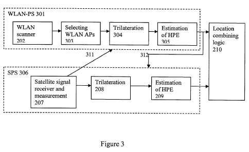
[0123] Figure 3 illustrates a block diagram of the hybrid system of a WLAN-PS
301
and a SPS 306.
[0124] SPS 306 is an off-the-shelf, conventional satellite positioning device
which
consists of the same devices as SPS 206 in Figure 2, with addition of an
output 311 and
an input 312 from the WLAN-PS (discussed in more detail herein). Satellite
receiver and
measurement device 207 is part of every conventional SPS receiver 306, and raw
SPS
measurements are an essential part of the SPS measurement. However, here the
raw SPS
measurements are used outside the SPS 306, as is shown by output 311. Not all
the
commercial SPS receivers expose the raw SPS measurements to devices outside
SPS 306.
For example, Star III GPS manufactured by SiRF Technology, Inc. (San Jose, CA)
provides raw SPS measurements as part of its standard interface. However there
are
some other GPS receivers that do not provide such measurements. For the SPS
receivers
-19-
CA 02727038 2010-12-06
WO 2009/149417 PCT/US2009/046504
that do not expose raw SPS measurements as part of their standard interface,
the SPS
receiver 306 is modified to permit access to the raw SPS measurements.
[0125] The WLAN-PS 301 functions in a similar manner as the WLAN-PS 201
shown in Figure 2 except that it is configured to receive raw SPS measurements
311. The
integration of the raw SPS measurement with WLAN-PS 301 changes the design of
WLAN APs selection device 303, trilateration device 304, and HPE estimation
device
305. The WLAN-PS 301 can take advantage of the raw SPS measurements when at
least
two satellites are acquired, even without any fix or solution from the SPS
306.
[0126] This design change of WLAN-PS 301 after receiving raw SPS measurements
is discussed in more detail herein.
[0127] Under one embodiment, the disclosed method integrates a WLAN- based
positioning system (WLAN-PS) and a satellite-based positioning system (SPS) in
which
the WLAN-PS provides a set of possible locations of a mobile device, and among
the
possible locations, the one which fits the SPS measurements the best is
selected as the
final position estimate.
[0128] This embodiment also can provide a method to integrate WLAN- based
positioning system (WLAN-PS) and satellite-based positioning system (SPS) in
which the
WLAN-PS provides a set of possible locations for the mobile device, and the
possible
locations are weighted according to their distance to a plurality of possible
SPS device
location solutions. In other words, weights are assigned to WLAN-PS possible
solutions
according how well they correspond to the satellite measurements. After
assigning a
weight to each possible location, various algorithms can be used to combine or
select
WLAN-PS possible locations. For example, the final reported location can be
weighted
by an average of all possible locations, low weight locations can be removed
from the
weighted average, or only the highest weighted location can be reported.
Selection can be
a special case of weighting, in which the respective weights are zero and one.
[0129] For example, because of the high density of WLAN APs in some areas,
WLAN-PS can detect tens of WLAN APs in a given location. The detected WLAN APs
may form more than one cluster. A cluster is defined as a set of APs in the
coverage area
of each other. If the coverage of a WLAN AP is not known, a nominal coverage
can be
considered. Nominal coverage or typical coverage of a WLAN AP is found
statistically
by measuring coverage for thousands of WLAN APs, and it is reported numbers
between
-20-
CA 02727038 2010-12-06
WO 2009/149417 PCT/US2009/046504
100m and 250m at the time of writing this document. For example, if a mobile
device
detects fifteen WLAN APs, in which ten of them are located in a high-rise
building and
the other five are located in an office building far from the high-rise
building (for
example, 500 meters away from the high rise building), the detected WLAN APs
can be
considered as two clusters with a size of ten and five, respectively.
Conventional
positioning algorithms would select the cluster with a higher number of APs:
the cluster
of ten APs. Under the conventional approach, the location would be somewhere
in the
high-rise building. However, if raw SPS measurements from two or more
satellites are
considered with the cluster information, even with no location estimate from
SPS, the raw
SPS measurements can be used to select the appropriate cluster of WLAN APs
from the
plurality of clusters. In this example, the cluster of five WLAN APs might be
selected as
the closest cluster to the location of the mobile device, because it also
satisfies the SPS
equations. SPS measurements also can be used to assign a weight to the
clusters of five
and ten APs according to their estimated distance from possible SPS solutions.
After
assigning a weight to clusters, logic can be used to combine the estimation
results of
clusters and report only one location. For example, the weighted average of
estimation
results of clusters, estimations of the cluster with maximum weight, or
average of
estimation of clusters with higher weights can be reported as final estimation
results.
[0130] The first step is detecting WLAN access points, which will be used as
reference points to locate the user device. WLAN access points are randomly
distributed,
and they also might move over time. Therefore, the WLAN positioning system
applies a
clustering algorithm to identify all the clusters of WLAN access points that
are detected
by the end user.
[0131] A cluster of WLAN access points is a set of WLAN access points which
are in
the coverage area of each other. WLAN access points which are farther than a
normal
coverage of an access point from the cluster are considered as a new cluster.
[0132] For example, a user detects four access points and three of them are
located in
Boston and one of them in Seattle. Therefore, they form two clusters: one in
Boston with
three WLAN access points and one in Seattle with one WLAN access point. Each
cluster
of WLAN access point can result to a separate location in a WLAN positioning
system.
If the mobile device also acquires signals from two or more satellites, the
satellite
measurements can be used to select the cluster of WLAN access points or reject
clusters
-21-
CA 02727038 2010-12-06
WO 2009/149417 PCT/US2009/046504
of WLAN access points. Two or more satellite measurements provide a set of
solutions
in a form of a region (volume, surface or a curve). The proximity of possible
WPS
solutions to SPS possible solutions can be criteria to weight, select, or
reject WPS
solutions. In other words, the closer the WLAN-PS solution to the SPS
solutions, the
higher the quality of the WLAN-PS solution.
[0133] For example, Figure 4 shows a WLAN-PS 401, which consists of five WLAN
access points 404. The WLAN access points form two clusters in this example, a
first
cluster 402 and a second cluster 403. Each cluster can be used to estimate the
location of
the user device. If the user device acquires a signal from at least two
satellites 405, the
possible solutions of the two or more satellites 406 can be used to select or
eliminate
some clusters. In this example, possible solution of the two or more
satellites is shown as
a band 406. Cluster 402 is closer to the possible satellite solutions band 406
than cluster
403. Therefore, cluster 402 can be selected and cluster 403 can be rejected.
[0134] Figure 5 illustrates block diagram of integrated solution of SPS and
WLAN-
PS. SPS 506 can be a standard, off-the-shelf device, but it has to be able to
provide raw
SPS measurements as discussed in Figure 3. The raw SPS measurements 311 are
directed
to WLAN APs 503 and trilateration device 504.
[0135] The WLAN APs selection devices 503 receives the data from WLAN scanner
202 as an input. The WLAN APs selection device 503 clusters WLAN APs based on
the
distance between the access points. The WLAN APs selection device 503 not only
identifies clusters, but also selects a different set of WLAN APs for each
cluster. Each
different cluster may result in a different location estimate. All of the
different sets of
clusters can be used in the trilateration device 504 and may result in a
different location
estimate. The location estimates based on clusters can be weighted according
to the
cluster distance from the SPS possible solutions or can be selected according
to their
cluster distance from SPS possible solutions. A cluster can be assigned a high
weight if it
is considered close (at a small distance) from the satellite distance
solution. For example,
if the cluster is located on the order of 10 meters away from the satellite
distance solution.
A cluster can be assigned a low weight if it is considered far (at a large
distance) from the
satellite distance solution, for example, if it is located on the order of 100
or 1,000 meters
away from the satellite distance solution.
-22-
CA 02727038 2010-12-06
WO 2009/149417 PCT/US2009/046504
[0136] The SPS solutions can be found as follows. In each satellite
measurement,
there are generally four unknowns coordinates of location of the mobile
device, (x,y,z)
and internal clock bias of SPS receiver. The raw SPS measurements from two or
more
satellites can be used to eliminate the internal clock bias of the SPS
receiver from the
equations. In this case, the result is going to be a function of coordinates
of the location
of the user device, (x,y,z), which can be written as a general form as
follows:
F(x,y,z) = 0.
[0137] This function can represent an area, a surface, or a curve based on
number of
satellites. Therefore, raw SPS measurements from two or more satellites can
result in a
set of possible solutions, even without having a final location estimate.
[0138] The distance between the different solutions of WLAN-PS and possible
solutions of SPS can be used as criteria to weigh each WLAN-PS solution. After
assigning a weight to each WLAN-PS possible solution, logic can be used to
combine the
solution or select the solution from the possible solutions.
[0139] Further, the consistency between the SPS measurements and the locations
provided by the WLAN-PS can be used as an indication of distance between the
locations
provided by the WLAN-PS and location of the mobile device. The location of the
user
device can be calculated by (1) using the possible WLAN-PS locations as rough
estimates
of the location of the user device (i.e., using each possible WLAN-PS location
as the
x,y,z) and (2) calculating the final unknown, internal satellite receiver
clock bias, for each
WLAN-PS location estimate using the measurements from each satellite. The
consistency between the calculated internal satellite receiver clock biases
(calculated for
each satellite in view) for each WLAN location estimate can be used as an
indicator of
distance between WLAN-PS's location estimate and the mobile device actual
location.
Good WLAN-PS estimates will have consistent receiver clock bias estimates,
i.e., when
that WLAN-PS estimated location is used as the x,y,z location, for each
satellite, the
receiver clock bias will be substantially the same, for example, within about
10% of each
other. However, if the WLAN-PS location is a poor estimate of the location of
the user
device, the WLAN-PS location will produce varied satellite receiver clock bias
estimates
for each satellite, for example, the receiver clock biases will vary by at
more than 10%.
-23-
CA 02727038 2010-12-06
WO 2009/149417 PCT/US2009/046504
[0140] If clock bias which is found for each satellite measurement is denoted
by Ci,
the consistency of Ci can be used as a measure of distance between a given
position (in
this case, locations determined by the WLAN-PS) and the locations that satisfy
the
satellite equations. The consistency of Ci can be measured with different
mathematical
approaches, like standard deviation of Ci, or mean square error of Ci
estimation as
follows:
N
Yj 1. i
C = t 1
N
N
Y(C -C)2
MSE = i=1
N
[0141] The value of MSE can be used as an indicator of the consistency of the
Ci
samples. Therefore, all possible locations of WLAN-PS can be examined with SPS
raw
measurements, and the consistency of Ci can be used as an indicator of the
solution's
distance to the actual mobile device location. This distance can be used with
other
WLAN AP parameters to weight or select or deselect (remove) an AP in the
process of
calculating the mobile device location.
[0142] Figure 6 shows SPS solution in form of a region 606 and a WLAN
positioning
system 601, in which WLAN access points 604 form a first cluster 602 and a
second
cluster 603. The mobile device acquisition of two or more satellites 605 also
can result in
a set of possible satellite device solutions 606. The consistency between the
SPS
solutions 606 and WLAN-PS solutions 602 is used to select the best solution,
which is the
602 solution of WLAN-PS in this example. The consistency between the SPS and
WLAN-PS means both of them report the same location as part of their solutions
or that
the final estimated position is one of the solutions of both systems. Further,
a cluster of
APs can be weighted according to their distance to possible solutions of SPS.
[0143] Another embodiment of the disclosed subject matter provides a method to
weigh WLAN access points by using raw SPS measurements. Selecting the best set
of
WLAN access points to estimate end user's location by using raw SPS
measurements can
be a specific case of assigning a weight to WLAN APs. In addition to other
criteria used
-24-
CA 02727038 2010-12-06
WO 2009/149417 PCT/US2009/046504
to weight or select the best set of WLAN access points to estimate the mobile
device
location, raw SPS measurements can be used or combined with the other
criteria. Other
criteria and weights are weight based on received signal strength or weight
based on
round trip time of received signal. The WLAN-PS uses WLAN APs and their
characteristics to estimate the location of a mobile device.
[0144] The characteristics of a WLAN AP might include, but are not limited to,
received signal strength (RSS), location or estimation of location, signal to
noise ratio,
and time of arrival (TOA). Raw SPS measurements from two or more satellites
are used
to calculate an indication of distance between location (or estimated
location) of WLAN
APs and actual location of the mobile device. This indication of distance can
be used to
select the best set of WLAN APs to estimate location of the mobile device, or
the
indicator of distance can be used to weight WLAN APs according to their
distance from
the device location. The raw SPS measurements from at least two satellites can
be used
in this process, with or without having a location estimate from SPS. The
distance is
considered far if the distance is more than an order of magnitude larger than
the coverage
area of the WLAN AP. A distance is considered close or not far is the distance
is within
an order of magnitude of the coverage area of the WLAN AP. WLAN APs that are
considered far can be eliminated from the positioning calculation.
[0145] Figure 7 shows an example of an integrated solution of WLAN-PS and SPS,
in
which the mobile device detects five WLAN access points 702 and has acquired a
signal
and raw measurements from two satellites 704. In this example, the WLAN access
points
are randomly spread around the mobile device, and distance between WLAN access
points 702 and possible solutions of two satellites 703 can be used as an
indication of
distance between WLAN access point and actual location of the mobile device. A
region
of possible SPS solutions 703 is calculated using measurements from two
satellites. The
distance between the WLAN access point 702 and SPS possible solution 703 is
used as an
indicator of distance between WLAN access point and actual location of the
mobile
device. In this example, all the WLAN access points 702-1 are very close to
SPS possible
solutions 703, but one WLAN access point 702-2 is not. Therefore, the longer
distance
between WLAN access point 702-2 and possible SPS solutions 703 is an indicator
of a
larger distance between WLAN access point 702-2 and the location of the mobile
device
compared to other detected WLAN access points 702-1. Thus, WLAN access point
702-
-25-
CA 02727038 2010-12-06
WO 2009/149417 PCT/US2009/046504
2 can be weighted according to its distance to SPS possible solutions, or it
can be
removed from the set of APs to calculate the mobile device location.
[0146] Figure 8 illustrates WLAN-PS 801 and SPS 806 integrated solution, in
which
all the modules are the same as Figure 2, except for selecting WLAN APs 803.
Selecting
WLAN APs 803 also receives raw SPS measurements 311 as an input. These raw
measurements are used to estimate the distance between the location (or
estimated
location) of WLAN APs and the location of the mobile device.
[0147] As discussed in the previous embodiment, in this embodiment there is a
need
to calculate an indication of the distance between WLAN APs location (or
estimated
location) and actual location of the mobile device using SPS measurements from
two or
more satellites. The consistency between the raw SPS measurements and the WLAN
APs
can be used as an indication of distance between the location of WLAN APs and
the
location of the mobile device. The consistency can be calculated by (1) using
the WLAN
AP's location as an estimation of the location of the mobile device and (2)
calculating the
receiver clock bias for each WLAN AP location based on the measurements from
each
satellite. The consistency between calculated receiver clock biases can be
used as an
indicator of distance between WLAN APs location and the mobile device's actual
location.
[0148] In other words, after applying the location of a WLAN AP as an initial
position in SPS equations using pseudorange measurements, the only remaining
unknown
is the receiver clock bias, which is the same for all SPS raw measurements. If
clock bias
which is found for each satellite measurement is denoted by Ci, the
consistency of Ci is
used as a measure of distance between the given position (in this case,
location of WLAN
AP) and the location that satisfies the satellite equations. Consistency of Ci
can be
measured with different mathematical approaches, like standard deviation of
Ci, or mean
square error of Ci estimation as follows:
N
Yj 1. i
C = t 1
N
N
Y(C -C)2
MSE = i=1
N
-26-
CA 02727038 2010-12-06
WO 2009/149417 PCT/US2009/046504
[0149] The value of MSE can be used as an indicator of the consistency of the
Ci
samples. Therefore, the location of all the detected WLAN APs can be examined
with
SPS raw measurements, and the consistency of Ci can be used as an indicator of
their
distance to the mobile device location. This indicator can be used with other
AP
parameters to weight, select, or remove an AP in the process of calculating
the mobile
device location.
[0150] Under another embodiment of the disclosed subject matter, a system and
method is provided in which the WLAN-PS provides a region in which a possible
location solution resides, and within the provided region, the final location
estimate of the
mobile device is selected based on SPS measurements from two or more
satellites.
[0151] Figure 9 shows an integrated WLAN-PS and SPS, in which WLAN-PS 901
provides an estimate of the location of the mobile device with some
uncertainty 903. The
uncertainty 903 can be the expected error of WLAN-PS. The mobile device also
acquires
signal from two or more satellites 902. Using all the points within the
uncertainty area
903 reported by WLAN-PS, the location 904 which fits the satellite
measurements the
best is selected as the best estimate of location of the mobile device.
[0152] The best point which fits satellite solutions within that region can be
found by
dividing the uncertainty area 903 to small grids and evaluating each grid
point as is
shown in Figure 10. The distance between grid lines can be based on the
required
accuracy of location estimation and the quality of the SPS measurements. The
higher the
accuracy requirement and the quality of the SPS measurements, the smaller the
distance
between the grid lines can be and the more accurate the location estimate. For
example,
the grid lines can be between about 5 meters and about 100 meters apart,
preferably at
about 10 meters apart.
[0153] In this embodiment, the number of SPS satellites 902 can be two or
more.
This system or method can be used in cases where the SPS cannot determine the
location
of the mobile device by itself but where the WLAN-PS possible solution 903 can
be
examined with the SPS information to select as the best location 904 the one
that is most
consistent with the SPS pseudorange equations.
[0154] Figure 11 shows an integrated solution of WLAN-PS 1101 and SPS 1106, in
which final location estimate provided by WLAN-PS is refined by using SPS
-27-
CA 02727038 2010-12-06
WO 2009/149417 PCT/US2009/046504
measurements 311 from two or more satellites. A new module, refining module
1111, is
added to conventional WLAN-PS, which receives WLAN-PS trilateration results,
the
corresponding uncertainty of those measurements, and SPS measurements from two
or
more satellites. Using this information, the refining module 1111 reports the
location
estimate of the mobile device.
[0155] For example, if the WLAN-PS provides a sphere of possible location
solutions
to refining module 1111. The size of the sphere corresponds to the uncertainty
of the
location estimate of WLAN-PS (expected error), which can be calculated for
each
position estimate in some embodiments, or the nominal value of uncertainty of
WLAN-
PS can be used. For example, median error of Skyhook Wireless WLAN-PS is about
30m, which can be used as nominal value of WLAN-PS error. In the next step,
SPS
measurements from two or more satellites can be used to find a point within
the specified
region by WLAN-PS, which satisfies the SPS measurements the best. The
satellite
equation for each satellite is written as follows:
Fi(x,y,z,b)=0
[0156] In which (x, y, z) is location of the mobile device, and b is denoted
for the
internal clock bias of SPS receiver. Any point within the specified region by
WLAN-PS
provides an estimate for the location of the mobile device, (x, y, z), and
internal clock
bias is calculated for each acquired satellite. Because all the measurements
are done at
almost the same time by the same SPS receiver, the internal clock bias of SPS
receiver
should be almost the same for all the SPS measurements. Therefore, as
discussed
previously, the consistency between receiver clock biases of SPS receiver
calculated from
different acquired satellites can show the distance between location estimate
(x,y,z) and
actual location of the mobile device. The consistency of the calculated
internal clock of
SPS receiver can be measured by calculating the standard deviation of the
receiver clock
bias measurements.
[0157] In the case where the specified region by WLAN-PS is divided into a
grid, the
SPS equations are examined at each grid point. The grid point which provides
the most
consistent receiver clock bias for all the acquired satellites is the best
location estimate of
the mobile device.
[0158] Another embodiment of the invention provides a method to reduce
acquisition
time of SPS by providing a position estimate of WLAN-PS as an initial position
to SPS.
-28-
CA 02727038 2010-12-06
WO 2009/149417 PCT/US2009/046504
Providing an initial position by WLAN-PS can reduce the acquisition period of
the SPS
and therefore reduces time to first fix of SPS. Satellite positioning systems
already
provide a method to receive an initial position, and how they use the provided
initial
position inside SPS is generally known. The present system uses a WLAN-PS
location
estimate as a source of initial position for the satellite positioning system.
Because the
location of SPS satellites are known at any time, knowledge of a rough
location of the
mobile device can help the SPS to reduce the set of satellites it searches for
to the set of
satellites actually visible to the device, instead of all of the satellites,
thereby reducing
searching time.
[0159] Figure 12 illustrates a WLAN-PS 201 and SPS 1203, in which WLAN-PS
provides an initial position 1211 to the SPS system. Thus, the estimated
location of the
mobile device 1211 by the WLAN-PS 201 can be provided as initial position to
SPS
1202. Knowing the initial position of the mobile device can assist SPS 1202 to
select the
best set of the satellites to search and reduce time to fix a location of the
device.
[0160] The WLAN-PS and the SPS can work independently and provide estimates of
attributes of a mobile device, including location estimation, expected error
in the location
estimation, velocity, and bearing estimation. However, because WLAN-PS has a
much
shorter time to first fix (TTFF) than SPS, the estimated location by WLAN-PS
can be
provided to SPS as initial position of the mobile device, reducing the time
required to find
location.
[0161] The receipt of an initial position is a standard practice in SPS, and
most of the
SPS receivers provide a method to receive the initial position. Here the WLAN-
PS is
used as the source of providing the initial position to SPS.
[0162] Another embodiment of the invention provides a method to increase the
accuracy of the expected error of location estimate of the integrated location
solution of
SPS and WLAN-PS and compare the error to the error location result for each
individual
system. The expected error estimation provides an uncertainty area around the
estimated
location. If estimated location of WLAN-PS and SPS are within the uncertainty
area of
each other, the uncertainty area is reduced based on distance between
estimated locations
from both systems. If estimated locations of WLAN-PS and SPS are not within
the
uncertainty area of each other, the uncertainty area is increased based on
distance between
estimated locations from both systems. If only one of the estimated locations
of WLAN-
-29-
CA 02727038 2010-12-06
WO 2009/149417 PCT/US2009/046504
PS and SPS falls inside the uncertainty area of the other system, the
uncertainty area can
be reduced or increased based on quality of estimated error from each system.
The
estimated error of location estimate normally reports the 95% confidence
interval, but it
can report any other confidence interval as well.
[0163] Another embodiment of the invention provides a method to increase the
accuracy of the expected error of a location estimate of the integrated
location solution of
SPS and WLAN-PS. The WLAN-PS provides a location estimate and the SPS acquires
at least two satellites. The expected error estimation provides an uncertainty
area around
the estimated WLAN-PS location. The consistency between the estimated location
of
WLAN-PS and raw SPS measurements is used as criteria to reduce or increase the
expected error estimate. If estimated location estimate of WLAN-PS and raw SPS
measurements are consistent, the uncertainty area is reduced based on distance
between
WLAN-PS estimated location from SPS possible solutions. If the estimated
location of
WLAN-PS and raw SPS measurements are not consistent, the uncertainty area is
increased based on distance between WLAN-PS estimated locations from SPS
possible
solutions.
[0164] Figure 13 illustrates WLAN-PS location estimation 1301 and WLAN-PS
expected error of estimation 1303 and also SPS location estimation 1302 and
SPS
expected error of estimation 1304. The reported uncertainty by each system is
the
expected error of position estimate.
[0165] In such a system, the SPS and WLAN-PS each provides a location estimate
and also an estimate of the expected error in that location estimation. The
expected errors
of the location estimate provided by both systems are combined in order to
provide a
better estimate of the error of the location estimation. For example, if each
system
provides an area around the reported location as an uncertainty of the
estimated location
(1303 and 1304), the integrated system considers the overlap of the
uncertainty areas
1305 and also the distance between estimated locations 1306 to estimate the
uncertainty
of the final location estimate. The greater the distance between the estimated
locations by
SPS and WLAN-PS is, the higher the expected error of location estimation. In
another
implementation, the system can select the location estimate with the lowest
uncertainty as
the final location estimate.
-30-
CA 02727038 2010-12-06
WO 2009/149417 PCT/US2009/046504
[0166] Figure 14 illustrates a block diagram of integrated WLAN-PS and SPS
system,
in which the expected error of each system is calculated using conventional
method and
the results are provided to integrated error estimation system device 1411.
The integrated
error estimation 1411 calculates the final expected error by considering the
consistency
between the reported locations by WLAN-PS and SPS. The consistency can also be
determined by comparing the receiver clock bias, as discussed previously.
[0167] In some embodiments, the SPS can detect that the mobile device is
stationary.
In general, it takes measurements from four SPS satellites to estimate the
velocity or
speed of a mobile device. The present method and system can determine if the
mobile
device is stationary by using the measurements from as few as two satellites
by
examining the consistency of the Doppler frequency measurements from the two
or more
satellites. If the device is stationary, the Doppler measurements from SPS
must be fully
accounted for by satellite motion relative to initial position of the device
and the
frequency offset of the receiver clock. The receiver clock offset can be
estimated, given
the Doppler measurements from two or more satellites. The hypothesis that the
user is
stationary is based on the size of the residuals after the estimated receiver
frequency bias
is substituted in the SPS Doppler equations.
[0168] By knowing that a mobile device is stationary, the hybrid system can
cause the
WLAN-PS to respond differently than when the device is in motion. For example,
WLAN-PS can save power by updating the location less often, for example, once
a
minute. In addition, the WLAN-PS can consider all of the detected WLAN access
points
over the time interval that the mobile device is stationary and use the
collective
information to estimate an improved location of the mobile device. This is
because the
WLAN-PS can obtain a better estimate of the received signal strength from an
access
point and better mitigate power fluctuation due to multi-path when user is
stationary.
Multipath is the propagation phenomenon that results in radio signals reaching
the
receiving antenna by two or more paths and causes power to fluctuate, and it
is a known
phenomena by experts in the radio propagation field.
[0169] Figure 15 illustrates stationary user detection based on two or more
satellites.
[0170] If the mobile device 1503 detects two or more satellites, 1501, 1502
one can
determine that the mobile device is stationary or moving from Doppler
measurement of
the received signal from satellites.
-31-
CA 02727038 2010-12-06
WO 2009/149417 PCT/US2009/046504
[0171] The first step is finding a rough location of the mobile device 1503,
which can
be calculated by WLAN-PS. This rough estimate of location of the mobile device
can be
provided by other positioning technologies as well. The rough estimation of
the location
of the mobile device can have an error of up to about a couple of kilometers
although
accuracy of rough estimation of location by WLAN-PS is maximum couple of
hundred
meters.
[0172] The mobile device can acquire a signal from at least two satellites,
which are
shown with satellites 1501 and 1502 in Figure 15. The mobile device also knows
the
velocity of the satellites at the exact time of signal acquisition. In other
words, if the
mobile device 1503 acquires a signal from satellites 1501 and 1502 at time t,
the velocity
of the satellites at time t also is known by the mobile device. The mobile
device 1503 can
determine the velocity of the acquired satellites 1501 and 1502 by decoding
the messages
received from the satellites, as all satellite broadcasts its velocity at any
moment of time.
The mobile device can also receive satellite velocity from other sources, for
example, a
cellular network.
[0173] Velocity is a vector with magnitude and direction, and it was shown
with
velocity of Vi and V2 for satellites 1501 and 1502, respectively. Doppler
frequency due
to satellite movement is calculated based on velocity. The simplified equation
to find
Doppler frequency for each satellite is as follows:
vl
f dl - 2
(1)
v2
.fat - 2
[0174] The k is wavelength of SPS radio wave and it is known for any SPS
system,
andfd is the Doppler frequency.
[0175] The mobile device measures the frequency of the received signal from
each
satellite. Since the transmit frequency of each satellite is known, the mobile
device can
measure the difference between the frequency of the received signal and the
transmitted
signal. The difference between received and transmitted frequency are denoted
by fõ 21 and
f12 for satellites 1501 and 1502, respectively.
-32-
CA 02727038 2010-12-06
WO 2009/149417 PCT/US2009/046504
[0176] If the mobile device frequency offset of the internal clock is f, and
the velocity
of the mobile device 1503 is v,n, the measured frequency from each satellite
is calculated
as follows:
fdl cos(al) + f, + cos( 1) = f.,
(2)
{ \ \ {
Jd2cos(a2)+fo+ X cOS~2)=Jm2
[0177] The angles ai and a2 are between the velocity vector of the satellites
and the
lines connecting the mobile device to the satellites for satellite 1501 and
1502,
respectively. The mobile device can calculate the angles based on the devices
location,
the location of the satellites, and the velocity vector of the satellites. If
the mobile device
is stationary, the above equations are rewritten as follows:
J{dl cos(a1) + fo = fm'l (3)
Jd2cos(a2)+fo J m2
[0178] The only unknown for the mobile device in these equations isfo, and it
can be
found from each satellite equation independently. If the mobile device is
stationary, the
values of fo from all the acquired satellites are going to be the same. In
other words, if the
values offo from equations for all the acquired satellites are not the same,
the mobile
device is not stationary.
[0179] Another embodiment of the disclosed subject matter relates to a method
for
providing characteristics of the environment of a mobile device by using WLAN-
PS.
WLAN APs are stationary radio transceivers with relatively small coverage,
which are
surveyed for positioning purposes. During the survey process, one of the
characteristics
associated with the WLAN APs can be characteristics of the environment. Then
the
detected WLAN access points by a mobile device are used collectively to
determine the
environment in which a mobile device is operating. The environmental
characteristics
can be considered as attributes of WLAN access points, for example, density of
buildings
-33-
CA 02727038 2010-12-06
WO 2009/149417 PCT/US2009/046504
near the AP height of buildings near AP, and whether the AP is in an urban
canyon,
urban, or suburban location. The data on the environmental characteristics of
the access
points can reside in the reference database of the access points and can be
obtained there
by the user device. The granularity of the area, which is characterized by
WLAN access
points, can be different, and it can be as small as a building or as big as a
neighborhood.
Environmental information can be used by SPS, WLAN-PS, and also an integrated
solution of both systems to adjust the systems approach to position
acquisition and/or for
power management. For example, knowledge of the fact that a mobile device is
in an
urban canyon environment might cause the hybrid system to rely on WLAN-PS
alone,
while in a suburban environment, SPS might be considered as the primary source
of
estimation of position and other attributes of the mobile device.
[0180] Another embodiment of the disclosed subject matter and system provides
a
method to maintain the stability of the internal clock of a SPS receiver by
using the
WLAN APs. This can be accomplished by measuring known time intervals of the
signal
transmitted by a WLAN device equipped with a stable clock. Maintaining the
internal
clock stability of a SPS receiver is important for position determination. For
example, it
can help in acquiring satellite signals faster, being able to operate at lower
power, and
also providing a fix (location estimation) with fewer satellites. A WLAN
standard
defines constant time intervals, including, but not limited to, some packet
headers, some
fields in some packets, as in WLAN 802.11 standard DIFS (DCF Inter Frame
Space),
SIFS (Short Inter Frame Space), or slot duration, and a mobile device can use
these
known time intervals to measure its internal clock bias over time and maintain
its
stability.
[0181] There might be WLAN access points with different clock stability. In
this
case, data identifying the access points which are equipped with a stable
clock can be
considered as part of characteristics of the WLAN AP and/or the
characteristics can
reside in the access point data base and can be obtained from there.
[0182] In addition to providing initial position and clock information, the
WLAN
positioning system can provide clock updates to the WLAN-enabled SPS receiver.
Every
SPS receiver is equipped with an internal oscillator in order to maintain its
indication of
GPS clock information. However, because these oscillators are imperfect at
maintaining
an exact measurement of time, the clocks internal to the SPS receivers drift.
This clock
-34-
CA 02727038 2010-12-06
WO 2009/149417 PCT/US2009/046504
drift can cause position estimation errors. By the WLAN-PS providing the
correct GPS
clock information to the SPS system, the WLAN positioning system facilitates
avoiding
such position estimation errors. Furthermore, because the SPS receivers are
able to
maintain a highly accurate measure of the GPS clock information, they can
operate at
relatively lower signal to noise ratio (SNR) values in the position estimation
calculations.
Maintaining SPS timing by SPS receiver reduces time uncertainty of received
signals
from satellites. Therefore, it is easier to extract signal from noise, and SPS
receiver can
detect weaker signal and operate in harsher locations in terms of SPS signal.
Thus
aspects of the method allow SPS receivers to operate in areas having less that
ideal SPS
signal conditions.
[0183] Another embodiment of the present disclosure relates to using WLAN
municipal networks to increase the accuracy of SPS receiver estimations by
providing
initial timing and location information to the SPS receiver. WLAN municipal
networks
are city wide WLAN networks which are installed in city by city officials or
under their
supervision to provide wireless connection using WLAN technology. Aspects of
this
method and system of improving SPS receiver position estimation accuracy by
using
WLAN municipal network data consists of the following items:
[0184] In order to assist the SPS position estimation by providing GPS clock
information, the municipal WLAN access points should be synchronized with the
GPS
clock. WLAN access points of a municipal network can be synchronized with the
GPS
clock by using one of the following methods as examples: (1) use of SPS
enabled WLAN
APs where each WLAN AP in a municipal network can be equipped with a device
which
extracts the GPS clock information from GPS radio signals, (2) use of
centralized clock
distribution entity synchronized where the GPS clock information can be
extracted at one
place and then distributed to all the WLAN APs in the municipal network, and
(3) use of
a high quality oscillator in WLAN AP. An oscillator is used to measure time
and
maintain synchronization with the GPS clock. As long as the quality of the
WLAN AP
oscillator is higher than the SPS receiver oscillator, the timing provided by
the WLAN
AP is going to be higher than the SPS receiver. Therefore, the SPS receiver
can use
WLAN AP to maintain its timing better than using its internal clock. The
single module
that extracts the GPS clock information (herein "Clock Distribution Entity")
is the only
-35-
CA 02727038 2010-12-06
WO 2009/149417 PCT/US2009/046504
unit and only place which extracts the GPS clock information and then provides
timing to
all the WLAN access points in the network.
[0185] Further, when the WLAN receiver is integrated into the SPS receiver the
SPS
receiver can use the WLAN receiver to extract timing information from the
signals
received from WLAN access points of WLAN municipal networks. While the idea of
providing initial timing to SPS receiver has been explained for WLAN municipal
networks, it can be applied to any WLAN network which is synchronized to a GPS
clock.
[0186] Upon review of the description and embodiments of the present
invention,
those skilled in the art will understand that modifications and equivalent
substitutions
may be performed in carrying out the invention without department from the
essence of
the invention. Thus the invention is not meant to be limiting by the
embodiments
described explicitly above and is limited only by the claims which follow.
Further, the
features of the disclosed embodiments can be combined, rearranged, etc.,
within the scope
of the invention to produce additional embodiments.
[0187] What is claimed is:
-36-