Note: Descriptions are shown in the official language in which they were submitted.
CA 02780820 2012-05-11
WO 2011/059911 PCT/US2010/055807
1
MONITORING TRAFFIC SIGNAL PREEMPTION
FIELD OF THE INVENTION
[001] The present invention is generally directed to traffic control
preemption systems.
BACKGROUND
[002] Traffic signals have long been used to regulate the flow of traffic at
intersections.
Generally, traffic signals have relied on timers or vehicle sensors to
determine when to
change traffic signal lights, thereby signaling alternating directions of
traffic to stop, and
others to proceed.
[003] Emergency vehicles, such as police cars, fire trucks and ambulances,
generally
have the right to cross an intersection against a traffic signal. Emergency
vehicles have
in the past typically depended on horns, sirens and flashing lights to alert
other drivers
approaching the intersection that an emergency vehicle intends to cross the
intersection. However, due to hearing impairment, air conditioning, audio
systems and
other distractions, often the driver,,of a vehicle approaching an intersection
will not be
aware of a warning being emitted by an approaching emergency vehicle.
[004] Traffic control preemption systems assist authorized vehicles (police,
fire and
other public safety or transit vehicles) through signalized intersections by
making a
preemption request to the intersection controller. The controller will respond
to the
request from the vehicle by changing the intersection lights to green in the
direction of
the approaching vehicle. This system improves the response time of public
safety
personnel, while reducing dangerous situations at intersections when an
emergency
vehicle is trying to cross on a red light. In addition, speed and schedule
efficiency can
be improved for transit vehicles.
[005] There are presently a number of known traffic control preemption systems
that
have equipment installed at certain traffic signals and on authorized
vehicles. One such
system in use today is the OPTICOM system. This system utilizes a high power
strobe tube (emitter), located in or on the vehicle, that generates light
pulses at a
predetermined rate, typically 10 Hz or 14 Hz. A receiver, which includes a
photodetector and associated electronics, is typically mounted on the mast arm
located
at the intersection and produces a series of voltage pulses, the number of
which are
proportional to the intensity of light pulse received from the emitter. The
emitter
CA 02780820 2012-05-11
WO 2011/059911 PCT/US2010/055807
2
generates sufficient radiant power to be detected from over 2500 feet away.
The
conventional strobe tube emitter generates broad spectrum light. However, an
optical
filter is used on the detector to restrict its sensitivity to light only in
the near infrared (IR)
spectrum. This minimizes interference from other sources of light.
[006] Intensity levels are associated with each intersection approach to
determine
when a detected vehicle is within range of the intersection. Vehicles with
valid security
codes and a sufficient intensity level are reviewed with other detected
vehicles to
determine the highest priority vehicle. Vehicles of equivalent priority are
selected in a
first come, first served manner. A' preemption request is issued to the
controller for the
approach direction with the highest priority vehicle travelling on it.
[007] Another common system in use today is the OPTICOM GPS priority control
system. This system utilizes a GPS receiver in the vehicle to determine
location, speed
and heading of the vehicle. The information is combined with security coding
information that consists of an agency identifier, vehicle class, and vehicle
ID and is
broadcast via a proprietary 2.4 GHz radio.
[008] An equivalent 2.4 GHz radio located at the intersection along with
associated
electronics receives the broadcasted vehicle information. Approaches to the
intersection are mapped using either collected GPS readings from a vehicle
traversing
the approaches or using location information taken from a map database. The
vehicle
location and direction are used to determine on which of the mapped approaches
the
vehicle is approaching toward the intersection and the relative proximity to
it. The
speed and location of the vehicle is used to determine the estimated time of
arrival
(ETA) at the intersection and the travel distance from the intersection. ETA
and travel
distances are associated with each intersection approach to determine when a
detected
vehicle is within range of the intersection and therefore a preemption
candidate.
Preemption candidates with valid security codes are reviewed with other
detected
vehicles to determine the highest priority vehicle. Vehicles of equivalent
priority are
selected in a first come, first served manner. A preemption request is issued
to the
controller for the approach direction with the highest priority vehicle
travelling on it. An
example GPS-based preemption system is described in US patent number
5,539,398.
[009] With metropolitan wide networks becoming more prevalent, additional
means for
detecting vehicles via wired networks such as Ethernet or fiber optics and
wireless
networks such as Mesh or 802.11 b/g may be available. With network
connectivity to
CA 02780820 2012-05-11
WO 2011/059911 PCT/US2010/055807
3
the intersection, vehicle tracking information may be delivered over a network
medium.
In this instance, the vehicle location is either broadcast by the vehicle
itself over the
network or it may broadcast by an intermediary gateway on the network that
bridges
between, for example, a wireless medium used by the vehicle and a wired
network on
which the intersection electronics resides. In this case, the vehicle or an
intermediary
reports, via the network, the vehicle's security information, location, speed
and heading
along with the current time on the vehicle. Intersections on the network
receive the
vehicle information and evaluate the position using approach maps as described
in the
Opticom GPS system. The security coding could be identical to the Opticom GPS
system or employ another coding scheme.
[010] As used herein, the term "emitter" refers to the various types of
modules capable
of communicating a preemption request to a preemption controller. This
includes, for
example, IR light based modules, GPS based modules, and wireless network based
modules.
SUMMARY
[011] The embodiments of the present invention provide various methods and
apparatus for monitoring traffic signal preemption at one or more
intersections. In one
embodiment a method includes displaying a road map with a computer system. The
road map includes a plurality of roads and intersections. Preemption data is
periodically
transmitted from at least one preemption controller at a respective
intersection to the
computer system, and at least one traffic signal icon is displayed proximate
the
respective intersection on the road map. In response to receiving the
preemption data,
the road map is updated to include a vehicle icon at a location on the map
corresponding to a location of a vehicle transmitting a preemption request as
indicated
by the preemption data.
[012] In another embodiment, a system is provided for monitoring traffic
signal
preemption at one or more intersections. The system includes a processor and a
memory arrangement coupled to the processor. The memory arrangement is
configured with instructions that are executable by the processor for
performing the
steps including outputting data for displaying a road map which includes a
plurality of
roads and intersections. Preemption data is periodically requested and
received from at
least one preemption controller at a respective intersection. At least one
traffic signal
CA 02780820 2012-05-11
WO 2011/059911 PCT/US2010/055807
4
icon is displayed proximate the respective intersection on the road map. In
response to
receiving the preemption data, data are output for updating the road map to
include a
vehicle icon at a location on the map corresponding to a location of a vehicle
transmitting a preemption request as indicated by the preemption data.
[013] An article of manufacture is provided in another embodiment. The article
of
manufacture includes a computer-readable storage medium configured with
instructions
that are executable by one or more processors for monitoring traffic signal
preemption
at one or more intersections. The instructions when executed by the one or
more
processors cause the one or more processors to perform the operations of
outputting
data for displaying a road map which includes a plurality of roads and
intersections.
Preemption data are periodically transmitted from at least one preemption
controller at a
respective intersection to the computer system.
[014] At least one traffic signal icon is displayed proximate the respective
intersection
on the road map. In response to receiving the preemption data, data are output
for
updating the road map to include a vehicle icon at a location on the map
corresponding
to a location of a vehicle transmitting a preemption request as indicated by
the
preemption data.
[015] It will be appreciated that various other embodiments are set forth in
the Detailed
Description and Claims which follow.
BRIEF DESCRIPTION OF THE DRAWINGS
[016] Various aspects and advantages of the invention will become apparent
upon
review of the following detailed description and upon reference to the
drawings in which:
[017] FIG. 1 is an illustration of a typical intersection having traffic
signal lights;
[018] FIG. 2 shows an example display screen in which a road map is displayed
in
combination with traffic signal and vehicle icons for illustrating in near
real-time the
status of one or more preemption controllers;
[019] FIG. 3 is a block diagram of a system for monitoring traffic signal
preemption in
accordance with one or more embodiments of the invention;
[020] FIG. 4 is a flowchart of an example process for monitoring traffic
signal
preemption at a plurality of intersections in accordance with an embodiment of
the
invention; and
CA 02780820 2012-05-11
WO 2011/059911 PCT/US2010/055807
[021] FIG. 5 is a block diagram of an example computing arrangement which can
be
configured to implement the processes performed by the preemption controller
as
described herein.
DETAILED DESCRIPTION
[022] The embodiments of the present invention generally provide a method of
monitoring traffic signal preemption at multiple, geographically disperse
intersections. A
prior system for monitoring the activity at a traffic signal controller
presented a table of
data that includes a vehicle identifier and GPS coordinates for each vehicle.
As
preemption requests are received by a traffic signal controller as a vehicle
approaches
the intersection, preemption data are forwarded to the monitoring system. The
table of
data indicates a geographical location of the vehicle along with other data
from the
vehicle such as heading and speed. The data in the table are often used for
determining whether or not the preemption controller at the intersection,
which reacts to
preemption requests by signaling a request for preemption of the traffic
signal, is
configured and operating as intended.
[023] Of particular interest are the approach maps configured into the
preemption
controller. The approach maps set the boundaries of areas from which
preemption
requests will be processed. If an approach map is too small, the intersection
may not
be cleared in time to allow the requesting vehicle to pass without stopping.
If an
approach map is too large, the intersection may be cleared too soon and
unnecessarily
interfere with traffic flow in other directions.
[024] With tabular data one cannot easily determine whether or not an approach
map
is of a suitable size. For example, by displaying the GPS coordinates of a
vehicle, a
traffic engineer could not easily determine whether or not a vehicle is within
the
boundary of an approach map of the preemption controller unless the engineer
had
memorized the GPS coordinates of the approach map. In addition, the position
in the
table for the data of each vehicle is subject to change due to a drop in
communication
between the vehicle and the traffic signal controller, making it difficult for
the engineer to
track particular vehicles. The embodiments of the present invention provide
approaches for easily and accurately monitoring preemption activity at
geographically
disperse intersections.
[025] The monitoring of traffic signal preemption at one or more intersections
includes
displaying a road map with a computer system. The road map includes a
plurality of
CA 02780820 2012-05-11
WO 2011/059911 PCT/US2010/055807
6
roads and intersections. The area covered by the displayed road map is
selected by a
user. For one or more preemption controllers at respective intersections, the
preemption controllers periodically transmit their preemption data to the
computer
system. In response to receiving the preemption data, for each active
preemption, the
road map is updated to include a traffic signal icon at the respective
intersection and a
vehicle icon at a location on the map corresponding to a location of a vehicle
transmitting a preemption request as indicated by the preemption data.
[026] FIG. 1 is an illustration of a typical intersection 10 having traffic
signal lights 12.
The equipment at the intersection illustrates the environment in which
embodiments of
the present invention may be used. A traffic signal controller 14 sequences
the traffic
signal lights 12 to allow traffic to proceed alternately through the
intersection 10. The
intersection 10 may be equipped with a traffic control preemption system such
as the
OPTICOM Priority Control System.
[027] The traffic control preemption system shown in FIG. 1 includes detector
assemblies 16A and 16B, signal emitters 24A, 24B and 24C, a phase selector
(not
shown), a traffic signal controller 14, and a preemption controller 18. The
detector
assemblies 16A and 16B are stationed to detect signals emitted by authorized
vehicles
approaching the intersection 10. The detector assemblies 16A and 16B
communicate
with the phase selector, which is typically located in the same cabinet as the
traffic
controller 14.
[028] In FIG. 1, an ambulance 20 and a bus 22 are approaching the intersection
10.
The signal emitter 24A is mounted on the ambulance 20 and the signal emitter
24B is
mounted on the bus 22. The signal emitters 24A and 24B each transmit a signal
that is
received by detector assemblies 16A and 16B. The detector assemblies 16A and
16B
send output signals to the phase selector. The receiver circuit 18 processes
the output
signals from the detector assemblies 16A and 16B to determine the signal
characteristics including: frequency, intensity, and security code of the
signal waveform,
or pulses. The security code, consisting of the vehicle class and vehicle
identification is
encoded in the signal by interleaving data pulses between the base frequency
pulses.
In GPS systems, location, speed, and heading of the vehicle are also
transmitted and
determined. If an acceptable frequency, intensity, and or security code are
observed
the phase selector generates a preemption request to the traffic signal
controller 14 to
.+ pt n normal traffic ssignal sequence The phase selector alternately issues
prCiemlll Q ~EV1~~IGeI t c~uw ty~~ a .~t.~uc.~wa.. e ei~. Nip ... J
CA 02780820 2012-05-11
WO 2011/059911 PCT/US2010/055807
7
preemption requests to and withdraws preemption requests from the traffic
signal
controller, and the traffic signal controller determines whether the
preemption requests
can be granted. The traffic signal controller may also receive preemption
requests
originating from other sources, such as a nearby railroad crossing, in which
case the
traffic signal controller may determine that the preemption request from the
other source
be granted before the preemption request from the phase selector. In some
embodiments of the present invention the function of the phase selector is
performed
solely by the traffic controller.
[029] Based on the security code/priority encoded in each signal received, the
phase
selector determines whether to preempt traffic control. For example, the
ambulance 20
may be given priority over the bus 22 since a human life may be at stake.
Accordingly,
the ambulance 20 would transmit a preemption request with a security code
indicative
of a high priority while the bus 20 would transmit a preemption request with a
security
code indicative of a low priority. The phase selector would discriminate
between the low
and high priority signals and request the traffic signal controller 14 to
cause the traffic
signal lights 12 controlling the ambulance's approach to the intersection to
remain or
become green and the traffic signal lights 12 controlling the bus's approach
to the
intersection to remain or become red.
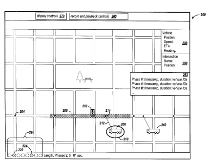
[030] FIG. 2 shows an example display screen 200 in which a road map is
displayed in
combination with traffic signal and vehicle icons for illustrating in near
real-time the
status of one or more preemption controllers. The grid represents roads
surrounding a
selected preemption controller.
[031] In the example display, one preemption controller has been selected for
monitoring. The selected preemption controller is represented by the traffic
signal icon
202. The selected preemption controller may be in communication with other
preemption controllers, which are shown as small squares in the intersections.
Block
204 is an example of one of those preemption controllers. Example
communications
between preemption controllers include information such as identities of
vehicles for
which those preemption controllers have detected a preemption request. This is
sometimes used to forward a preemption request from one preemption controller
to
another. While only one preemption controller has been selected for
monitoring, it will
be appreciated that multiple preemption controllers may be monitored and
respective
preempt;-- data pr esentev on a single map.
on .mete ~~. rte
CA 02780820 2012-05-11
WO 2011/059911 PCT/US2010/055807
8
[032] Approach maps are also displayed for the preemption controller being
monitored.
The approach maps are shown collectively as crosshatched area 206. It will be
appreciated that approach maps may be defined for all approaches to an
intersection,
even though the example shows maps for approaches only from the left and right
of the
intersection.
[033] In response to a request for preemption data, the monitored preemption
controller (shown as signal 202), transmits preemption data to the requester.
In the
example, the preemption data indicates that a high priority vehicle is
requesting
preemption. The vehicle is represented with icon 208. In one embodiment,
different
icons are used for different priority vehicles. For example, for a high
priority emergency
vehicle, such as a fire engine, a fire engine icon may be displayed. For a low
priority
vehicle, such as a mass transit vehicle, a bus icon may be displayed. It will
be
appreciated that different icons may be chosen for specific vehicle types,
which may be
identified by the vehicle identifier in the preemption data.
[034] In another embodiment, a third priority level is recognized. The third
priority level
is referred to as probe priority. In probe priority, the preemption controller
is being
tested for its ability to receive preemption requests. The preemption
controller does not
signal the traffic signal controller to preempt the traffic signal for a
preemption request
having a probe priority. When the monitoring system receives preemption data
indicating a probe priority preemption request, an icon other than one
depicting an
emergency vehicle or one depicting a mass transit vehicle is chosen. For
example, the
icon may show an automobile with an oversized antenna.
[035] In response to the preemption data indicating that the vehicle is
requesting
preemption, the vehicle icon is highlighted in the display. In one embodiment,
ellipse
210 is added to the display when the vehicle is requesting preemption and that
vehicle
is within one of the approach maps of the preemption controller. The display
also
shows dashed line 212 leading from icon 208 to the location 214 on the road
from which
the vehicle transmitted the preemption request. It may be observed that the
vehicle
location is within the approach maps 206, which causes the preemption
controller to
signal a preemption request to the traffic signal controller. Once the
preemption
controller loses communication with the vehicle and is no longer receiving
preemption
requests from that vehicle, the vehicle icon is removed from the display.
CA 02780820 2012-05-11
WO 2011/059911 PCT/US2010/055807
9
[036] The display 200 also includes graphical objects 220 that correspond to
the
phases of the traffic signal controller at the monitored intersection. In the
example,
there are 8 phases of the traffic signal controller, each represented by one
of the objects
220. US patent number 5,734,116 describes the phases of a traffic signal
controller. In
one embodiment, the display 200 highlights those phases that are green as
indicated by
the preemption data. The example shows objects 222 and 224, which correspond
to
phases 2 and 6, respectively, being highlighted with diagonal fill lines. In
one
embodiment, the objects are colored green. The combination of the highlighted
vehicle
icon (ellipse 210), which indicate preemption requests from the vehicle, and
the green
phases 2 and 6 in favor of the requesting vehicle illustrate an active
preemption by the
traffic signal controller for the vehicle corresponding to vehicle icon 208.
In addition to
showing which phases are green, the display shows the duration for which the
phases
have been held green. The example shows phases 2 and 6 having been held green
for
81 seconds. Displaying the length of green time for each phase allows the user
to
observe that the green time was extended for purposes such as transit signal
priority
(TSP), which provides assurances that the preemption system is operating
correctly and
providing extended green time in the desired direction.
[037] In addition to the graphical depiction of the preemption data,
additional vehicle-
specific data maybe presented on display 200. The additional vehicle data may
be
displayed in response to user selection of a vehicle icon (e.g., a double
click) in one
embodiment. Information such as the vehicle position in GPS coordinates,
vehicle
speed, vehicle heading, and estimated time of arrival at the intersection may
be
displayed, as shown by block 230. It will be appreciated that the speed of the
vehicle
may, in combination with the graphical display, indicate that the approach
maps need to
be adjusted. For example, if the vehicle is still or moving very slowly, and
is within the
area defined by the approach maps, this may indicate that the intersection has
not yet
cleared and the approach maps may need to be enlarged to allow more time to
clear
the intersection. Other information, which may be useful to display, includes
the serial
number of the emitter and the vehicle code assigned to the emitter.
[038] The monitoring system displays vehicle icons for all vehicles identified
in the
preemption data. For example, the preemption controller may have received
preemption requests from vehicles that are not within the approach maps of
that
CA 02780820 2012-05-11
WO 2011/059911 PCT/US2010/055807
preemption controller. A vehicle icon is displayed for each such vehicle. In
display 200,
vehicle 240 corresponds to such a vehicle.
[039] For vehicles in which the preemption data indicate a disable mode, a
grayed-out
vehicle icon is displayed. The disable mode indicates that an emitter
continues to issue
signals with an encoded priority level, but the signal does not request
preemption. For
example, when a bus door is opened to allow passengers on or off the bus, the
emitter
is set to disable mode so that the bus preemption request is not issued.
[040] In one embodiment, the monitoring system also displays textual data
describing
the intersection being monitored. This information includes, for example, the
name of
the intersection and GPS position of the intersection, as shown by block 250.
Depending on implementation requirements, this data may be displayed in
response to
user selection of a traffic signal icon or displayed permanently.
[041] A table 252 is displayed in another embodiment. Table 252 contains a
historical
list of phase changes that occurred while preemption data was gathered. A list
entry
contains the phase number, associated identifiers of vehicles, if any, that
requested
preemption, a timestamp indicating the time the phase started and the duration
for
which the phase was green. The table 252 may be permanently displayed or
selectively
displayed in response to user control.
[042] Another embodiment of the monitoring system provides record and playback
controls 260, along with display controls 270. The record and playback
controls provide
the user with the ability to record the preemption data as it is received by
the monitoring
system and play back the recorded data at a later time. The record and
playback
controls provide functions such as record, stop, play, step forward, step
back, rewind,
and fast-forward. The display controls allow the user to zoom in, zoom out,
and pan the
map. A distance measuring tools is provided to measure the distance from an
emitter
or preemption controller to the location of the cursor on the map.
[043] FIG. 3 is a block diagram of a system for monitoring traffic signal
preemption in
accordance with one or more embodiments of the invention. Traffic lights 302
and 304
at intersections with preemption controllers are coupled to traffic signal
controllers 310
and 314, respectively. Traffic signal controllers 310 and 314 are connected to
respective preemption controllers 316 and 318. A preemption monitoring system
320
and the preemption controllers are respectively coupled to network adapters
322, 324,
rious embodiments a router or a
.J 7J26 for communication over al n r n newo r% aJLV twork 328. In, various
embodiments
ication
and
CA 02780820 2012-05-11
WO 2011/059911 PCT/US2010/055807
11
network switch, as shown by router 330, may be coupled between the network
adapter
and the network. It is understood the preemption monitoring system 320 and the
preemption controllers 316 and 318 may be connected through more than one
network,
coupled by additional switches and routing resources, including a connection
over the
Internet.
[044] The preemption monitoring system 320 is additionally coupled to display
device
332 and to retentive storage device 334. The display device is used by the
preemption
monitoring system in displaying in near-real-time, the preemption data from
one or more
preemption controllers. The retentive storage stores preemption data that the
user has
elected to record via the record controls 260 of FIG. 2.
[045] In various embodiments of the present invention, an operator interacts
with the
preemption monitoring system 320 to select those preemption controllers for
which
monitoring is desired. The preemption monitoring system establishes
connections with
those selected preemption controllers and periodically requests the preemption
controller to send its most recent preemption data. That preemption monitoring
system
interprets that data and in response, outputs data for updating a map that is
displayed
on the display device 332. In response to an operator selecting a record
control, the
preemption monitoring system stores the preemption data in retentive storage
334 as it
is received from the selected preemption controller(s).
[046] It is understood that numerous network transfer protocols may be used to
establish, maintain, and route connections including: TCP/IP, UDP, NFS, ESP,
SPX,
etc. It is also understood that network transfer protocols may utilize one or
more lower
layers of protocol communication such as ATM, X.25, or MTP, and on various
physical
and wireless networks such as, Ethernet, ISDN, ADSL, SONET, IEEE 802.11,
V.90/v92
analog transmission , etc.
[047] FIG. 4 is a flowchart of an example process for monitoring traffic
signal
preemption at a plurality of intersections in accordance with an embodiment of
the
invention. At step 402, a communication connection is established between the
preemption monitoring system and one or more selected preemption controllers.
Once
a connection is established, the preemption monitoring system at step 404
requests the
approach maps from the selected preemption controller(s). The approach maps
are
only read once since they are unlikely to be changed while monitoring.
CA 02780820 2012-05-11
WO 2011/059911 PCT/US2010/055807
12
[048] At step 406, the preemption monitoring system prepares a road map and
displays the map on a computer monitor, for example. In one embodiment, the
GPS
data defined in the approach maps is used to obtain an electronic road map
from a
geographic information system. The preemption monitoring system then displays
the
electronic road map.
[049] The preemption monitoring system begins requesting preemption data from
the
selected preemption controller(s) at step 408. The selected preemption
controller
responds with tracking and preemption information.
[050] At step 410, the preemption monitoring system receives the preemption
data
from the selected preemption controller(s). The preemption data include
vehicle
identifier, velocity, priority level, estimated time of arrival, position,
heading, distance to
intersection, emitter identifier, green phases. At step 412 the displayed road
map is
updated accordingly. Examples of the updates to the map include those
described in
FIG. 2.
[051] For GPS-based preemption controllers and emitters, updates to the map
may
include those updates shown in FIG. 2. For IR-based systems, however, the
information conveyed from the preemption controller to the preemption
monitoring
system would be more limited. Specifically, the preemption data would not
include
speed, location, heading, or estimated time of arrival data. Rather, the
information may
be limited to timestamps of preemption requests and whether or not the
selected
preemption controller(s) is requesting preemption from the traffic signal
controller, and
the green phases of the traffic signal controller and the associated
durations. In
addition, for an IR-based system there would be no approach maps displayed.
The
position of the vehicle icon on the road map would be estimated based on the
signal
strength of the emitter.
[052] At step 414, the preemption monitoring system waits for a small period
of time
(e.g., 1 second) before returning to step 408 to submit another request(s) for
preemption data from the selected preemption controller(s).
[053] Those skilled in the art will appreciate that various alternative
computing
arrangements, including one or more processors and a memory arrangement
configured with program code, can be configured to perform the processes of
the
different embodiments of the present invention.
CA 02780820 2012-05-11
WO 2011/059911 PCT/US2010/055807
13
[054] FIG. 5 is a block diagram of an example computing arrangement which can
be
configured to implement the processes performed by the preemption controller
as
described herein. Those skilled in the art will appreciate that various
alternative
computing arrangements, including one or more processors and a memory
arrangement configured with program code, would be suitable for hosting the
processes
and data structures and implementing the algorithms of the different
embodiments of
the present invention. The computer code, comprising the processes of the
present
invention encoded in a processor executable format, may be stored and provided
via a
variety of computer-readable storage media or delivery channels such as
magnetic or
optical disks or tapes, electronic storage devices, or as application services
over a
network.
[055] Processor computing arrangement 500 includes one or more processors 502,
a
clock signal generator 504, a memory unit 506, a storage unit 508, a network
adapter
514, and an input/output control unit 510 coupled to host bus 512. The
arrangement
500 may be implemented with separate components on a circuit board or may be
implemented internally within an integrated circuit. When implemented
internally within
an integrated circuit, the processor computing arrangement is otherwise known
as a
microcontroller.
[056] The architecture of the computing arrangement depends on implementation
requirements as would be recognized by those skilled in the art. The processor
502
may be one or more general purpose processors, or a combination of one or more
general purpose processors and suitable co-processors, or one or more
specialized
processors (e.g., RISC, CISC, pipelined, etc.).
[057] The memory arrangement 506 typically includes multiple levels of cache
memory, a main memory. The storage arrangement 508 may include local and/or
remote persistent storage such as provided by magnetic disks (not shown),
flash,
EPROM, or other non-volatile data storage. The storage unit may be read or
read/write
capable. Further, the memory 506 and storage 508 may be combined in a single
arrangement.
[058] The processor arrangement 502 executes the software in storage 506
and/or
memory 508 arrangements, reads data from and stores data to the storage 506
and/or
memory 508 arrangements, and communicates with external devices through the
input/output control arrangement 510. These functions are synchronized by the
clock
CA 02780820 2012-05-11
WO 2011/059911 PCT/US2010/055807
14
signal generator 504. The resource of the computing arrangement may be managed
by
either an operating system (not shown), or a hardware control unit (not
shown).
[059] The present invention is thought to be applicable to a variety of
systems for a
preemption controller. Other aspects and embodiments of the present invention
will be
apparent to those skilled in the art from consideration of the specification
and practice of
the invention disclosed herein. It is intended that the specification and
illustrated
embodiments be considered as examples only, with a true scope and spirit of
the
invention being indicated by the following claims.