Note: Descriptions are shown in the official language in which they were submitted.
LIGHT RAIL VEHICLE MONITORING AND STOP BAR OVERRUN SYSTEM
CROSS REFERENCE TO RELATED APPLICATION(S)
[001] This Application claims the benefit of and priority to United States
Provisional Patent
Application Serial No. 61/514,692, filed August 3,2011.
BACKGROUND OF THE INVENTION
1. Field of the Invention.
[002] This disclosure is related to the field of systems for the monitoring
of mass transit
systems, such as light rail transit, trains, trams and metros, whose routes
are integrated with
and/or intersect roads, pedestrian crossways or other vehicular or human
passageways for ingress
or egress.
2. .. Description of Related Art.
[003] Due, in part, to an rising concern over increasing greenhouse gas
emissions associated
with individual motor vehicle commutes, the ever-escalating prices of gasoline
and the increased
traffic flow and congestion associated with rising metropolitan populations,
mass transit systems
have generally seen an increase in ridership in recent years. With this rising
ridership comes an
increase in the number of mass transit units and routes and, thus, an
increased presence of mass
transit commuter vehicles on or near motor or pedestrian throughways. For
example, the
Houston METRO operates about seven and one half (7.5) miles of surface rail
line for light rail
transit (LRT). This LRT system is integrated with and operates on Houston city
streets and
currently carries about 40,000 riders a day.
[004] Integrating the increase in ridership and mass transit units on LRT
lines with existing
motor vehicle and pedestrian streets and walkways creates obvious logistical
and operating
concerns. Accordingly, reliable and effective maintenance and monitoring
systems for operating
mass transit systems, such as LRT, are becoming increasingly important.
CA 2844536 2018-12-19
CA 02844536 2014-02-06
WO 2013/020070
PCT/US2012/049568
Systems with the capability of monitoring non-vital signal elements of street-
running LRT
systems with increased reliability and decreased operating and maintenance
costs are
therefore desirable.
[005] Important non-vital signal elements to be monitored by such systems
include, but
are not limited to, on-board and station announcements (L e., communication to
passengers as
to when an Light Rail Vehicle (LRV) is approaching a station or stop); traffic
signal
prioritization and pre-emption; grade crossing initiations; automatic vehicle
location (AVL);
route selection at interlockings; maximum speed limit control; headway
maintenance; and
indications of a LRV on the wrong track proceeding in the wrong direction.
Another non-
vital signal element that is of particular concern is intersection stop bar
infringement. An
intersection stop bar is the defined stopping point for a vehicle or
individual at an
intersection. Stop bars can be designated by broad white lines on the rail or
road or more
tangible barriers such as retractable gates or bars. With the increasing
interaction between
LRVs and motor vehicle and pedestrian traffic flow at intersections, the
number of incidents
in which an LRV operator has passed a bar stop signal and improperly proceeded
into the
intersection, thus causing an accident, has increased. A monitoring system
with the
capability to monitor and discipline operators in a way that is fair and
impartial would be key
step in reducing this problem.
[006] Currently, a variety of different control and coordination systems
are utilized to
monitor LRT systems. One basically utilized mechanism is train-to-wayside
technology. In
this system, the movement of LRVs in the LRT route grid is monitored by an
embedded track
sensor system. Generally, this technology has the capability to monitor some
non-vital signal
elements such as: announcements in a station that a train is coming; next-
station messages
onboard LRVs; and route selection at the terminal stations.
2
CA 02844536 2014-02-06
WO 2013/020070
PCT/US2012/049568
[007] However,
there are serious problems associated with the currently utilized TWC
systems. Delays and significant maintenance costs have been incurred by city
transit systems
that utilize TWC, primarily related to the water infiltration of TWC circuit
boards. For
example, in areas of Houston where the TWC system was utilized, upon
incidences of heavy
rain, the streets would frequently fill with water which overflowed the curbs
and covered the
embedded track. The water would then seep through openings in the concrete,
causing water
damage to the circuit boards. As replacement boards for the TWC system cost
approximately
$1,000 each, the cost of annual maintenance upon metropolitan mass transit
systems to repair
and protect the TWC system from water damage became extremely high, a cost
that will only
grow as LRT routes and lines increase in number. In addition to the high
maintenance costs
associated with the currently utilized TWC system, it also suffers from an
inability to monitor
certain non-vital elements and does not provide the flexibility of changing
detection zones as
the monitoring zones are specifically tied to the specific tangible location
of the embedded
circuit boards. Accordingly, there is a need for an LRT monitoring and
operating system
which is capable of monitoring a wide variety of non-vital elements, while
also eliminating
embedded loops in the trackway and reducing the need for other wayside
detection
equipment.
3
CA 02844536 2014-02-06
WO 2013/020070
PCT/US2012/049568
SUMMARY OF THE INVENTION
[008] Because of these and other problems in the art, described herein,
among other
things, is a GPS-based control and monitoring system for LRT systems which
enables transit
personnel to track vehicle positions, progress and non-vital signals as LRVs
travel through
their routes while eliminating the capital and maintenance costs associated
with embedded
LRT monitoring systems.
[009] Accordingly, disclosed herein is a method for monitoring vehicle
positions,
progress and non-vital signals within a traffic grid, the method comprising:
having one or
more vehicles within a traffic grid, each vehicle having its own schedule;
establishing one or
more pre-defined detection zones within the traffic grid, each of the pre-
defined detection
zones having its own parameters and monitoring purpose; and determining when
the one or
more vehicles within the traffic grid have violated the parameters of the one
or more pre-
defined detection zones.
[010] In one embodiment of this method, it is contemplated that the
parameters of the
one or more pre-defined detection zones can be modified to account for
changing monitoring
and tracking needs.
[011] In another embodiment of this method, the information regarding pre-
defined
detection zone activity and progression of the one or more vehicles within the
traffic grid will
be displayed in real-time at centrally-located monitors.
[012] In yet another embodiment of this method, the information regarding
traffic flow
patterns and violations of the one or more pre-defined detection zones will be
reported and
stored in a detailed log.
[013] In still another embodiment of this method, at least one of the one
or more pre-
defined detection zones will be an advanced detection zone, wherein the
advanced detection
4
CA 02844536 2014-02-06
WO 2013/020070
PCT/US2012/049568
zone is located prior to a stop on a vehicle's route and, upon identifying a
vehicle entering the
advanced detection zone, a notification announcement is triggered.
[014] In yet another embodiment of this method, at least one of the one or
more pre-
defined detection zones will be a stop bar overrun zone, wherein the stop bar
overrun zone is
located after a designated stop point on the vehicle's route and, upon
identifying a vehicle
entering the stop bar overrun zone at an improper time, the vehicle's
violation is recorded.
[015] In still another embodiment of this method, at least one of the one
or more pre-
defined detection zones will be a gate-closure zone, wherein the gate closure
zone is located
prior to an intersection with a gate on a vehicle's route and, upon
identifying a vehicle
entering the gate-closure zone, an instructional signal is sent to the
upcoming gate to either
open or close the gate prior to the vehicle's arrival.
[016] In a further embodiment of this method, at least one of the one or
more pre-
defined detection zones will be a speed-governing zone, wherein the speed of a
vehicle
entering the speed-governing zone is detected and, if the speed is above a
certain pre-defined
velocity parameter, an instructional signal is sent to the operator of the
vehicle to slow down
the speed of the vehicle. It is contemplated that, when the speed of the
vehicle is above a
certain pre-defined velocity parameter when entering the speed-governing zone,
a speed
governor is activated to decrease the vehicle's speed.
[017] In yet another embodiment of this method, at least one of the one or
more pre-
defined detection zones is a switch-track zone, wherein when the vehicle
enters the zone an
instructional signal is sent to switch an upcoming track on the vehicle's
route.
[018] It is contemplated that the parameters of each of the pre-defined
detection zones in
this method are chosen from the group consisting of: zone width, zone length,
required
vehicle speed and allowable heading variance.
CA 02844536 2014-02-06
WO 2013/020070
PCT/US2012/049568
[019] Also disclosed herein is a method for establishing a plurality of pre-
defined
detection zones within a traffic grid, the method consisting of: recording a
vehicle's route
within a traffic grid with general systems manager software; opening the
recorded vehicle's
route with the general systems manager software at a central control center;
selecting starting
and ending points for one or more pre-defined detection zones on the vehicle's
route within
the traffic grid; assigning parameters for each of the selected pre-defined
detection zones on
the vehicle's route within the traffic grid; and assigning appropriate
corrective actions for
when a vehicle fails to meet the assigned parameters for each of the selected
pre-defined
detection zones on the vehicle's route within the traffic grid.
[020] In addition, disclosed herein is a system for monitoring when a
vehicle overruns a
stop bar at an intersection within a traffic grid, the system comprising: a
pre-defined detection
zone located in a traffic grid after a stop bar at an intersection; wherein if
a vehicle is detected
within the pre-defined detection zone located in the traffic grid after the
stop bar at an
intersection when the stop bar is engaged, the system will determine that a
violation has
occurred; wherein when the system determines that a violation has occurred an
alert will be
sent through a network to a central control system; and wherein the central
control system
will record a log of the violation, the log including information chosen from
the group
consisting of: date of occurrence, time of occurrence, vehicle identification
number, stop bar
signal state, train speed and global satellite positioning strength. It is
contemplated that this
system may be configured to recognize and adapt to an inherent latency in the
calculation and
transfer of signals in the system.
6
CA 02844536 2014-02-06
WO 2013/020070
PCT/US2012/049568
BRIEF DESCRIPTION OF THE DRAWINGS
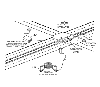
[021] FIG. 1 provides a general overview of a street-view of the light rail
vehicle
monitoring and stop bar overrun system.
[022] FIG. 2 provides a perspective view of a stop bar detection zone in
the light rail
vehicle monitoring and stop bar overrun system.
[023] FIG. 3 provides a diagram of a series of possible detection zones
which can be set-
up in the light rail vehicle monitoring and stop bar overrun system.
[024] FIG. 4 provides an embodiment of a Signal Bar Overrun Report of the
LRT
monitoring and control system.
[025] FIG. 5a provides an embodiment of the on-screen table of a central
monitor
software log and FIG. 5b provides an embodiment of a general grid monitoring
map of the
LRT monitoring and control system.
[026] FIG. 6 and FIG. 7 provide an embodiment of an interface utilized by
the systems
manager software to set up the pre-defined detection zones.
[027] FIG. 8 provides an example of the inherent latency period experienced
for stop bar
overrun detection zones.
7
DESCRIPTION OF THE PREFERRED EMBODIMENTS
[028] This disclosure is intended to teach by way of example and not by way
of limitation.
As a preliminary matter, it should be noted that while the description of
various embodiments of
the disclosed system will discuss application of the control and monitoring
system of this
application with light rail transit (LRT) systems, this in no way limits the
application of the
disclosed control and monitoring system to use in only LRT applications.
Rather, any mass
transit system which could benefit from the control and monitoring system
described herein
(including, without limitation, trains, metros, trams, streetcars, buses or
other mass transit
systems utilizing crossing signals including, but not limited to those using
dedicated traffic lanes)
is contemplated.
[029] In a broad sense, the LRT monitoring and control system combines
satellite position
navigation systems and dead-reckoning technology with secure radio
communications to
accurately control and monitor LRT units, allowing transit personnel to track
vehicle positions
and progress as they travel through their routes. It is contemplated that, in
certain preferred
embodiments, the LRT monitoring and control system disclosed herein will run
in conjunction
with or function as a component of the estimated time of arrival (ETA) traffic
control systems
disclosed in United States Utility Patent Applications Serial Nos. 13/535,231
and 13/535,234,
filed June 27, 2012.
[030] Generally, as LRT units move along their routes in the LRT monitoring
and control
system disclosed herein, they enter various pre-defined detection zones. Each
of these various
detection zones are pre-defined through the applicable global positioning
system (GPS)
technology and serve a distinct monitoring purpose in the overall system.
These detection zones
are adaptable; i.e., they can be modified and varied by transit personal to
account for changing
monitoring and tracking needs. Further, a certain set of parameters
8
CA 2844536 2018-12-19
CA 02844536 2014-02-06
WO 2013/020070
PCT/US2012/049568
are defined for each of the detection zones. Zone parameters include, but are
not limited to,
minimum or maximum vehicle speeds, basic vehicle detection, vehicle direction
en route, and
the amount of space between vehicles within the traffic grid, amongst others.
When a vehicle
in a detection zone does not meet the defined parameters, a violation will be
deemed to have
occurred. In addition, the LRT monitoring and control system allows for the
display of maps
of LRT unit and intersection activity on centrally-located monitors or in the
LRT unit in real
time and for the creation of detailed logs and reports of traffic flow
patterns, safety violations
and activity in real time for monitoring personnel.
[031] The LRT monitoring and control system described herein is generally
structured as
follows. In its basic form, the hardware components of the system include a
vehicle
equipment unit/vehicle computer unit (VCU) (101) installed in vehicles and a
priority
detector (103) installed in or near signal control cabinets (along with a
cabinet- or pole-
mounted antenna). As will be described further herein, the basic hardware
components of the
system (generally the VCU (101) and the priority detector (103)) generally
communicate
wirelessly using secure frequency hopping spread spectrum radio. The mobile-
vehicle
mounted hardware components, such as the VCU (101), utilize GPS or other known
positioning technology to determine the precise real-time location of the VCU
(101) and the
vehicle to which it is attached at all times.
[032] Generally, the VCU (101) is installed in a monitored vehicle in the
traffic grid. As
noted previously, contemplated monitored vehicles include, but are not limited
to, mass
transit vehicles (buses, trains, light rail, etc.), emergency vehicles (fire
trucks, police cars,
ambulances, etc.), waste management vehicles, and road maintenance vehicles.
It should be
understood that the system disclosed herein contemplates the installation of
one or more
VCUs (101) in various vehicles traveling and operating in the traffic grid.
9
CA 02844536 2014-02-06
WO 2013/020070
PCT/US2012/049568
[033] Generally, the VCU (101) serves several functions in the disclosed
LRT
monitoring and control system. For example, the VCU (101) determines the real-
time
location data for the vehicle in which it is installed. Further, the VCU (101)
also is capable of
sending information regarding its velocity, location and ETA to other
components of the
system to which it is communicatively attached, including a remote traffic
control center
(102), a plurality of secondary control centers (106), a plurality of other
VCUs (101), and a
plurality of priority detector units (103). In addition, the VCU (101) is also
capable of
receiving information from these other components in the system. Finally, the
VCU (101) is
capable of determining the location of the vehicle with respect to a plurality
of pre-defined
detection zones within the grid.
[034] The VCU (101) generally contains a receiver for a satellite
positioning navigation
system. Generally, any satellite positioning system known to one of ordinary
skill in the art
is contemplated including, but not limited to, the Global Positioning System
(GPS), the
Russian Global Navigation Satellite System (GLONASS), the Chinese Compass
navigation
system and the European Union's Galileo positioning system. Further, any
receiver
technology known to those of skill in the art that is able to calculate its
position by precisely
timing the signals sent by satellites is a contemplated receiver in the
disclosed system. The
installation of the receiver can be either permanent, by direct integration
into the light rail
vehicle (LRV), or temporary, through a mobile receiver that can be taken into
and removed
from the LRV. Generally, the receiver of the VCU (101) functions to determine
the LRV's
position, direction and velocity in real time at any given point during its
travels. Further, in
certain embodiments, the receiver of the VCU (101) will be utilized to define
the detection
zones and criteria for the detection zones for a given LRV route. In
alternative embodiments,
it is contemplated that the VCU (101) will determine its position, direction
and velocity
through inertial navigation systems known to those of ordinary skill in the
art alternatively or
CA 02844536 2014-02-06
WO 2013/020070
PCT/US2012/049568
in addition to through satellite positioning driven systems. Contemplated
inertial navigation
systems include, but are not limited to, dead reckoning, gyroscopic
instruments, wheel
rotation devices, accelerometers, and radio navigation systems.
[035] In addition to a receiver, the VCU (101) also contains a vehicle
computer which is
capable of transferring the location data, coordinates and speed of the LRV
and the
parameters of detection zones to a central control center (110) or a specific
priority
detector(s) (103) at a specific intersection. Another component of the VCU
(101) is a radio
transceiver. Generally, any device for the transmission and receiving of radio
signals
including but not limited to the FHSS and/or FH-CDMA methods of transmitting
radio
signals is contemplated.
[036] Notably, throughout this disclosure, the term "computer" will be used
to describe
hardware which implements functionality of various systems. The term
"computer" is not
intended to be limited to any type of computing device but is intended to be
inclusive of all
computational devices including, but not limited to, processing devices or
processors,
personal computers, work stations, servers, clients, portable computers, and
hand-held
computers. Further, each computer discussed herein is necessarily an
abstraction of a single
machine. It is known to those of ordinary skill in the art that the
functionality of any single
computer may be spread across a number of individual machines. Therefore, a
computer, as
used herein, can refer both to a single standalone machine, or to a number of
integrated (e.g.,
networked) machines which work together to perform the actions. In this way
the
functionality of the vehicle computer may be at a single computer, or may be a
network
whereby the functions are distributed. Further, generally any wireless
methodology for
transferring the location data created by the VCU (101) to either the central
control center or
particular priority detectors is contemplated in this disclosure. Contemplated
wireless
11
CA 02844536 2014-02-06
WO 2013/020070
PCT/US2012/049568
technologies include, but are not limited to, telemetry control, radio
frequency
communication, microwave communication, GPS and infrared short-range
communication.
[037] Another component of the VCU (101), in certain embodiments, is a
combination
GPS/UHF antenna. In the embodiment with the combination antenna, the combo
GPS/UHF
antenna contains the antennas for both the transceiver and the GPS unit.
Notably, however,
this combo antenna is not required and in other embodiments two separate
antennas can be
utilized. Generally, the combo antenna or separate antennas will be mounted on
the top of
the LRV, although this location is not determinative. Further, in certain
embodiments, the
antenna will be connected to the VCU (101) by two coax cable connections (one
for UHF and
one for GPS) although any method for connecting the antenna(s) to the VCU
(including both
wired and wireless technologies) is contemplated.
[038] Generally the VCU (101) will be programmed with preferred vehicle
response
settings, applicable intersections, the vehicle's schedule, a map of the
overall grid, and
vehicle detection zones for applicable signal lights in the grid. In certain
embodiments, it is
contemplated that the VCU will include a user interface known to those of
ordinary skill in
the art. Among other things, this user interface will provide a view of the
map of the overall
grid, vehicle detection zones for applicable signal lights in the grid, and
the location of other
VCU-equipped vehicles in the grid.
[039] In one embodiment, the VCU (101) will be powered directly by the LRV
battery.
In other embodiments, the VCU (101) will be powered by a portable power unit
known to
those of skill in the art including, but not limited to, batteries and solar
panels. Further, in
other embodiments, the VCU (101) will be powered by the general power system
employed
by the overall LRT system.
[040] A second component of the LRT monitoring and control system described
herein
is a plurality of priority detector units (103). The priority detector units
(103) of the disclosed
12
CA 02844536 2014-02-06
WO 2013/020070
PCT/US2012/049568
LRT monitoring and control system generally function to modify and control the
associated
signal light based upon the velocity, location, coordinatcs, ETA and priority
signals of VCU-
equipped LRVs in the traffic grid.
[041] The priority detector units (103) will generally be located at or
near particular
intersections and signal controllers in the area controlled by the disclosed
system. In one
embodiment, each priority detector (103) will be collocated within a
particular signal light
controller cabinet. However, this location is not determinative. It is
contemplated that the
priority detector (103) may be located at any proximity near a particular
signal light that
allows the priority detector (103) to receive applicable signals from either
the remote traffic
control center (102), secondary control centers (106), other priority detector
units (103)
and/or the VCUs (101) and allows the priority detector (103) to send signals
to the signal
controller (105) to modify the phases of the respective signal light at the
intersection that it
monitors.
[042] One component of the priority detector units (103) is the
intersection antenna
(201). This antenna (201) is any antenna known to those of skill in the art
that is capable of
receiving radio or other electromagnetic signals. In one embodiment, the
antenna will be co-
located with the priority detector (103). In other embodiments, the antenna
will be located at
a position removed from the priority detector (103). Generally, it is
contemplated that the
intersection antenna (201) may be located at any place near the applicable
intersection that
would allow for the effective transmission and receipt of signals. For
example, in certain
embodiments it is contemplated that the intersection antenna (201) will be
externally
mounted on a signal light pole at the intersection. In one embodiment, the
intersection
antenna (201) will be connected to the priority detector unit (103) by wire
connections, in one
embodiment by a coax cable connections (e.g., for UHF). In another embodiment,
the
13
CA 02844536 2014-02-06
WO 2013/020070
PCT/US2012/049568
intersection antenna (201) will be connected wirelessly to the priority
detector unit (103) in a
manner known to those of ordinary skill in the art.
[043] Further, different embodiments of the priority detector unit (103)
include a shelf-
mount version or a rack-mount version. In one embodiment of the rack-mount
version, is it
contemplated that the priority detector unit (103) will be able to be inserted
directly into two
adjoining card slots of a NEMA detector rack or Model 170 card file. However,
it should be
noted that any priority detector unit (103) design known to one of ordinary
skill in the art that
is able to perform the functionality described in this application is
contemplated.
[044] The priority detector unit (103) will generally send a variety of
outputs using the
standard North, South, East and West discreet outputs for a signal controller
(105) based on
the LRV's geographical zone position in order to request signal priority for
an approaching
LRV or for a priority vehicle including a priority unit which may be
substantially identical to
an LRV. It may also include other geographical or virtual detection zones.
[045] Another component of the LRT monitoring and control system also
generally
located in the traffic cabinet is a high-speed data adapter. The high speed
adaptor assists in
the communication of output signals between the priority detector (103) and
the signal
controller (105). While any high-speed adapter known to one of ordinary skill
in the art is
contemplated, in one embodiment it is contemplated that the adaptor can use
RS232, SDLC,
Ethernet or other protocols to receive and output the large number of signals
(such as ETA
calls for each direction) from the priority detector (103) to the signal
controller (105).
[046] Generally, the priority detector unit (103) of the LRT monitoring and
control
system is capable of sending a variety of output calls to the signal
controller (105) with which
it is associated.
[047] Generally, the VCUs (101), priority detectors (103) and central
control center
(110) of the LRT monitoring and control system will be connected by a wireless
technology
14
CA 02844536 2014-02-06
WO 2013/020070
PCT/US2012/049568
known to those of skill in the art that allows for the free transfer of data
and information
between each of these components through a control network (104). The network
(104)
communicatively connects the different components of the system.
[048] Another component of the LRT monitoring and control system is the
central
control center (110). Generally, the central control center (110) is a central
server; i.e. a
computer or series of computers that links other computers or electronic
devices together.
Any known combination or orientation of server hardware and server operating
systems
known to those of skill in the art for servers is contemplated as the central
control center
(110). In one embodiment of the system, the central control center (110) is
linked to the
VCUs (101) and the priority detectors (103) of the system by a wireless
network that allows
for the free transmission of information and data there-between allowing
monitoring and
configuration of a number of priority detectors (103). In another embodiment
of the system,
the central control center (110) will be linked to the priority detectors by a
wired network.
[049] In a broad sense, the LRT monitoring and control system disclosed
herein, is
generally capable of reporting a vehicle's speed, distance and location
(amongst other
locational-defining variables) using fixed geographic detection methodologies.
Further, in
additional embodiments, the system can be structured and customized to modify
the detection
zones that will be utilized to monitor and control the LRV while traveling in
the LRT grid.
[050] In a fixed geographic detection method, the LRT monitoring and
control system
utilizes a satellite positioning navigation system, such as GPS, to create
virtual "loops," also
known as detection zones, which are set up at specific defined points along a
vehicle's route.
As vehicles equipped with a VCU (101) enter and pass through these detection
zones,
dependent upon the conditions and parameters of the detection zone, certain
actions are
taken. In certain embodiments, it is contemplated that the detection zone and
response data
will be stored in the VCU (101) as well as be sent to the central control
center (110).
CA 02844536 2014-02-06
WO 2013/020070
PCT/US2012/049568
[051] These geographical or virtual detection zones can be set-up at
various points along
the LRT transit route in order to handle positive train control functions;
i.e., to report vehicle
locations and activity in real time through the route and to alert drivers
and/or to govern
vehicle actions based on programmed parameters and the detected violations
thereof. Unlike
certain prior art systems, these detection zones are not limited to areas
where tangible circuit
boards are located.
[052] Examples of types of detection zones which can be set up by transit
authority with
the present LRT monitoring and control system include, but are not limited to,
the following
types of zones, some of which are provided in FIG. 3. The intersection
advanced detection
zone is a zone which generally functions to maintain the coordination of
upcoming traffic
signals at intersections. The parameters for these advanced detection zones
generally include
the detection of a vehicle within the zone. A "violation" of these advanced
detection zones
will have been deemed to occur when a vehicle is detected within the advanced
detection
zone. These advanced detection zones can also be utilized for the activation
of station and
on-board announcements of arrival times for the LRV. In this functionality,
once the
advanced detection zone is reached by the LRV, and confirmed by the GPS, a
signal is
transmitted to the control network which, in one embodiment, utilizes the
information
contained in the signal to coordinate the upcoming lights on the LRV' s
scheduled route. This
signal can also be utilized by the control network (104) to activate an
announcement of the
arrival time of the LRV at the upcoming stations on the route. Similarly, when
the advanced
detection zone is reached and confirmed by the GPS, a signal transmitted to
the VCU (101)
activates an on-board next-station announcement which is made by the LRV
internal PA
system. As demonstrated in FIG. 3, intersection detection zones are generally
located at a
point in an LRV's scheduled route at some point prior to an intersection.
16
CA 02844536 2014-02-06
WO 2013/020070
PCT/US2012/049568
[053] The check-in zone is a zone which generally functions to notify the
central control
center (110) that a train is at a designated stop. Generally, the check-in
zones are located on a
route at the designated stop, as seen in FIG. 3. However it is contemplated,
in certain
embodiments, that the beginning of the check-in zone can precede the platform
of the
designated stop and the end of the check-in zone can extend beyond the end of
the platform
of the designated stop. Similar to the advanced detection zone, signals sent
to the traffic
network (104) from an LRV reaching this stop can initiate announcements either
at the
station platform and/or in the internal LRT PA system.
[054] The check-out zone is a zone which generally functions to notify the
central
control center (110) that a train has left a designated stop. Generally, the
check-out zone will
be located at some point on a route at a reasonable distance after the
designated stop. In
embodiments where there is both a check-in zone and a check-out zone, the
check-out zone
will be located at a point somewhere on the route after the check-in zone.
Similar to the
advanced detection zones, the parameters for these check-in and check-out
zones generally
include the detection of a vehicle within the zone. A "violation" of these
check-in and check-
out zones will have been deemed to occur when a vehicle is detected within the
respective
check-in or check-out zones.
[055] The gate-closure zone of the system generally acts as a backup to
close the
crossing gate controls at upcoming intersections. Accordingly, as demonstrated
in FIG. 3, the
gate-closure zones of the system are generally located on an LRV's route prior
to an
upcoming intersection at a point that provides sufficient time for the central
control center,
wayside detector or some other detector system known to those of ordinary
skill in the art to
receive the signal transmitted to it the from the LRV entering the gate
closure zone and send
an instructional signal to the upcoming gate prior to the LRV's arrival.
17
CA 02844536 2014-02-06
WO 2013/020070
PCT/US2012/049568
[056] The speed-governing zone generally functions to detect an LRV's speed
upon
entering the zone. The parameters for these speed-governing zones generally
include either a
minimum or maximum vehicle speed within the zone. A "violation" of these speed-
governing zones will have been deemed to occur when it is determined that a
vehicle within
the speed-governing zone is either above or below the minimum or maximum
vehicle speed
parameter defined for that zone. It is contemplated that these zones may be
located at any
point along an LRV's route in the system where it is desirable to monitor, and
have the option
of controlling, the LRV's speed. For example, if it is determined that an LRV
is going too
fast upon entering one of these speed-governing zones, a signal can be sent to
the VCU (101)
to modify/slow down the speed of the LRV. Examples of areas where such zones
would be
desirable include, but are not limited to, areas of a route near schools,
pedestrian crossings,
shopping districts, commercial districts or other areas where heavy pedestrian
and/or vehicle
traffic is expected. In one embodiment of this zone, if an LRT unit is
traveling too fast as
detected by this zone and determined in the central control center (110), the
system can
activate an applicable speed governor to decrease the LRV's speed.
[057] The signal-priority zone generally functions to request priority at a
signal light
through an upcoming intersection. When an LRV arrives at the signal priority
zone, a
priority call is made to the applicable traffic priority controller through
the detector unit,
requesting priority for the LRV. Once the LRV leaves the applicable
intersection, the priority
request discontinues, enabling the signal controller to return to a normal
traffic control cycle.
Because these zones are intimately tied to the functioning of signal lights at
an upcoming
intersection, they are generally located at a point on an LRV's route at a
sufficient distance
prior to an intersection to allow for the signal to precipitate a change in
the signal light prior
to the arrival of the LRT unit.
18
CA 02844536 2014-02-06
WO 2013/020070
PCT/US2012/049568
[058] The stop bar
overrun zone generally functions to monitor specified safety
violations at stop bars or other intersection control systems, including
hypothetical
intersection stopping points based on the location of an intersection and the
flow of traffic.
The parameters for these stop bar overrun zones generally includes the
detection of a vehicle
within the zone. A "violation" of these stop bar overrun zone will have been
deemed to occur
when a vehicle is detected within the stop bar overrun zone. An embodiment of
a stop bar
overrun detection zone in the LRT monitoring and control system is provided in
FIG. 2. As
demonstrated in FIGs. 2 and 3, the stop bar overrun zone is generally located
on a route in the
intersection, at some point after the stop bar. By this location, the zone can
detect when a
given LRV has gone over or "overrun" the stop bar. Stated differently, if the
LRV is detected
within the stop bar overrun zone when the stop bar or other intersection
control system is
engaged, the system will know that a violation of the stop bar has occurred.
Thus, the VCU
(101) determines the status of the stop bar signal and, through the use of
GPS, determines if
the LRV has passed or "overrun" the stop bar and stop bar signal during a
period when the
stop bar was down; i.e., when the LRV was in actuality supposed to stop at the
stop bar and
not proceed into the intersection as detected by the zone. If the system
determines that a
specified safety violation has occurred, such as overrunning an intersection
stop signal, the
time and LRV number will be recorded by the system and an alert will be sent
through the
network (104) to the central control system (110) and the LRT monitoring and
control system
will record a log of the improper LRV activity. A Signal Bar Overrun Log can
then be
created by the LRT monitoring and control system which includes a detailed
report of,
amongst other things: date and time of occurrence; train ID; direction of
travel; route and
cross streets; intersection and zone IDs; bar signal state (as well as
preceding and subsequent
signal states); alarm sounded; train speed and GPS satellite strength. In one
embodiment, the
central control computer will display a pop-up message on the display
interface to notify
19
CA 02844536 2014-02-06
WO 2013/020070
PCT/US2012/049568
personnel when an overrun has occurred. An embodiment of a Signal Bar Overrun
Log is
provided in FIG. 4. This particular detection zone and functionality of the
LRT monitoring
and control system provides a method through which transit operators can
impartially identify
and discipline LRV operators who violate stop bar signals.
[059] In certain embodiments of the system, the system will be configured
to recognize
and adapt to the inherent latency in the determination of the location of a
vehicle in the grid
as well as the transfer of signals from the VCU (101) to the central control
system (110) or
other component parts of the network (104). These latencies will generally be
referred to
herein collectively as overrun offset. Generally, when monitoring instances of
trains
overrunning intersection stop bars, there is a delay in the time the position
data information is
determined and calculated as well as the time the position data information is
transmitted to
the system via the network (104). Commonly, the latency period is about two to
three
seconds (though it may vary by location). For a train travelling 30 mph, this
amount of
latency could result in raw location data that is off by as much as 90 feet,
as demonstrated in
FIG. 8. Thus, to ensure accurate location data and reporting of stop bar
overruns, it is
contemplated that the system will offset the raw location data received for
the stop bar
overrun by a defined average latency period.
[060] The presence-detection zone generally activates when an LRV is within
the zone
and notifies the central control center of the LRV's location. This type of
detection zone is
often used to notify the transit network when an LRT unit has passed an
intersection. As
such, as demonstrated in FIG. 3, in certain embodiments this zone is located
at some point
after an intersection on the LRV's route.
[061] Another detection zone is the headway zone. This zone functions to
calculate the
distance between LRT units in order to maintain the proper spacing between the
LRT units.
The parameters for these advanced detection zones generally include a minimum
amount of
CA 02844536 2014-02-06
WO 2013/020070
PCT/US2012/049568
allowable spacing between LRT vehicles. A "violation" of these headway zones
will have
been deemed to occur when the defined minimum amount of allowable spacing
between LRT
vehicles is not met. For example, if the defined minimum parameter is 4,000
feet and two
LRT units are within 3,500 feet of each other, the LRT monitoring and control
system can
take measures to slow the following LRV to achieve the proper headway between
it and the
preceding LRV. Similar to the speed-governing zones, when vehicles are sensed
as too close
together via headway zones, the system can activate an applicable speed
governor to modify
the one or more applicable LRV's speeds to regain the desired distance between
LRVs.
Generally, it is contemplated that these zones may be located at any point
along the LRV's
route.
[062] Another
detection zone, the switch-track zone, functions to send a request for the
rail-control cabinet to switch tracks for the LRV based upon scheduling or a
request
authorized by the central control system (110). The parameters for these
switch-track zones
generally include the detection of a vehicle within the zone. A "violation" of
these switch-
track zones will have been deemed to occur when a vehicle is detected within
the switch-
track zone. Generally, these switch-track zones are located at or near the
intersection of two
or more tracks or at or near a switch-track zone on the LRV's route. Also
generally located
at this point along an LRV's route is the wrong detection zone. This zone
functions to alert
the transit network (104) when a train has entered the wrong track. Generally,
with this
detection zone the LRT monitoring and control system immediately sends a
signal to the
LRV operator, the operator of any oncoming LRVs on the same track and the
central control
center (110) alerting them to the position of the LRV on the wrong track. With
this detection
zone, if the LRVs get within a specified distance of each other, the LRT
monitoring and
control system can activate a dead-man switch and shut down the corresponding
LRVs.
21
CA 02844536 2014-02-06
WO 2013/020070
PCT/US2012/049568
[063] Another contemplated detection zone is the reverse running detection
zone.
Depending on the circumstances, there are certain periods of time when
sections of a track or
route in a LRT grid will have to be altered from their normal course to run in
a reverse
direction. Examples of such instances include, but are not limited to,
reversing the direction
to allow for track maintenance or to provide for additional vehicles in the
grid due to special
events. In these circumstances, zones may be established and set-up to trigger
alerts if the
LRV operator attempts to enter a "reverse run" section of the track going the
wrong direction.
The parameters for these reverse running zones generally include the detection
of a vehicle
within the zone. A "violation" of these reverse running zones will have been
deemed to
occur when a vehicle is detected within the reverse running zone. For example,
the detection
zone can be set up immediately prior to the portion of the "reverse run"
section of the track
where, traditionally, an LRV would enter. Thus, with the reverse running
detection zone,
upon entering the zone operators of the LRV could be notified that they were
entering this
section of the route from the wrong direction. It is contemplated that these
alerts may be
displayed and/or sounded at the central control center (110) and/or within the
LRV such that
corrective action could be immediately taken. It is contemplated that the
reverse run zones
may overlay an entire block of track or they may be set up at each end of the
reverse run
block.
[064] Yet another contemplated detection zone in the disclosed LRT
monitoring and
control system are virtual moving blocks. These "virtual moving blocks" are
used to ensure
that trains adhere to agency-defined block spacing. These moving blocks travel
with their
assigned LRVs and the block lengths automatically adjust based on train speed
(or as
calculated by braking algorithms). When the front or back of the defined
moving block
detects another LRV, an alert can be sent to either the operators of the
respective LRVs
encroaching upon each other or the central control center (110). It is also
contemplated that
22
CA 02844536 2014-02-06
WO 2013/020070
PCT/US2012/049568
these virtual moving blocks can be set up to send alerts when confirmation is
not received
about upcoming switch positions. By sending an alert when LRVs breach their
agency pre-
defined spacing levels, the virtual moving blocks operate to avoid both head-
on and rear-end
collisions, which may occur if a LRV has stopped or slowed down. Both
situations will
trigger an alert based on an algorithm in the VCU (101), which calculates for
potential
collisions based on the LRV's speed, distance and direction.
[065] It is
contemplated that detection zones may be set-up either at street-level, within
the LRV, or centrally at the central control system (110). Generally, the
associated systems
manager software enables personnel to proceed on the LRV while running a
laptop connected
to the VCU (101). At key points, zone start and stop points may be designated
and associated
parameters may be entered. Parameters include, but are not limited to, zone
width, required
vehicle speed, and allowable heading variance. In addition, certain vehicle
parameters can be
set up to serve as conditions for activating the appropriate or desired zone
response. For
example, a minimum velocity can be set up for a speed-governing zone. If the
LRV is above
this speed when entering the speed-governing zone, the system can notify the
LRV operator
of this inappropriate activity, log this improper activity and/or activate an
applicable speed
governor to slow down the speed of the LRV. In the embodiment in which the
detection
zones are set-up at street level, in a first step a zone-setup wizard in the
VCU is activated.
After activation, a default zone width and heading variance is selected. Then,
in a next step,
the applicable route and cross streets are entered. Then, once the vehicle
drives over a point
where the operator desires the zone to begin, the user selects the current
location of the LRT
unit as their starting point. After the starting point is entered, a
directional code is entered
and the zone heading is entered automatically. Next, once the LRT unit drives
over the point
where the operator desires the zone to end, the user selects the current
location as their ending
point. Then the operator commands the setup wizard to create the zone and the
newly created
23
CA 02844536 2014-02-06
WO 2013/020070
PCT/US2012/049568
zone is added to the LRT monitoring and control system database. The
parameters of the
database can be modified and changed at an alternate time if required.
[066] In the embodiment in which the zones are created at the central
control system
(110), general systems manager software is also utilized. In this methodology,
the default
heading variance and zone width are set with the general systems manager
software at the
central control system (110). In a first step with this software, while
driving pre-defined
routes, paths are recorded with the general systems manager software. Then,
after driving the
routes, the recorded paths are opened in the systems manager software program.
After a
given recorded path is opened, an intersection center point and the starting
and ending points
for each zone are selected. Further, desired parameters and pre-conditions can
be set up for
each of the respective zones. Once selected, the various created detection
zones will be
displayed on the systems manager software. Any edits to the zones will be
modified in this
view in real-time. In a third embodiment, zone set-up will occur at the
central control (110)
by designating key points (e.g., zone start, zone finish) strictly through the
use of integrated
GPS maps.
[067] An example of an embodiment of an interface utilized by the systems
manager
software ¨ both at the street level or at the central control system¨to
control how outputs
regarding signals and pre-defined zones in the system are exchanged is
provided in FIGS 6
and 7. As noted previously, the overrun offset field is used in conjunction
with the stop bar
overrun zone to adapt the system for the common latency period inherent in
signal
transference to ensure accurate location data and accurate reporting of stop
bar overruns.
[068] In alternative embodiments, it is contemplated that the detection
zones of the LRT
monitoring and control system can be enhanced through the use and installation
of
electromagnetic tags, such as RFID tags. It is contemplated that these
electromagnetic tags
may be installed at wayside locations to enhance vehicle-position accuracy. In
these
24
CA 02844536 2014-02-06
WO 2013/020070
PCT/US2012/049568
embodiments, electromagnetic tag readers are installed on each of the
respective LRVs in the
system. When the vehicle passes over an installed tag, the VCU (101)
recognizes its position
and triggers the appropriate alert for the detection zone or wayside location.
For example, a
tag installed at a LRV stop bar would prompt a violation alert if it is
activate by a vehicle
crossing the stop bar against the signal. Depending upon the embodiment, it is
contemplated
that these electromagnetic tag components of the system can either work
independently to
prompt alerts or in combination with detection zones of the LRT monitoring and
control
system described herein to augment the accuracy of that system.
[069] Generally, the communication and information exchange between the
components
of the disclosed the LRT monitoring and control system generally functions as
follows. The
GPS receiver of the vehicle control unit (101) located in the LRT unit,
through inputs
received from an applicable satellite system, determines the speed, direction,
velocity and
other pertinent geographic and coordinate information for the vehicle in all
monitored
approaches. Then, either constantly or at fixed time intervals (i.e., based
upon defined
detection zones), the vehicle computer of the VCU (101) transmits the raw
applicable
geographic and coordinate information for the LRV to the central control
center (102).
[070] As noted previously, in one embodiment of the central control center
(110) there
will be provided a central monitor which provides transit operators and
authorities the
capability of monitoring LRV location and activity in real-time. In one
embodiment, when
an LRV enters a detection zone under pre-defined conditions, the central
monitor logs the
LRV activity data on an on-screen table. Generally, any of the zones along a
route can be set
up to report into the log table. In another embodiment, the position of the
LRV in the LRT
system will consistently be displayed in real time
[071] The following offers an example regarding how the present LRT
monitoring and
control system, central control center (110) and detection zone log work
together in one
CA 02844536 2014-02-06
WO 2013/020070
PCT/US2012/049568
embodiment. First, as a particular LRV moves forward, it enters an advanced
detection zone.
Once within the zone, i.e., once the zone becomes active, the LRV transmits
the advance
detection signal to the upcoming traffic controller. In addition, the
transmitted vehicle data is
displayed in the on-screen activity log. Then, when the LRV enters the "at
station" zone, the
transit network is notified of its location and the entry of its coordinates
appears in the
activity log. As the LRV advances, each zone carries out its defined function
and the
applicable activity data is entered into the logged on screen. If an LRV runs
past a stop bar
(as detected by the stop bar zone and central control system (110)), the
occurrence is
highlighted on the activity log, an alarm is sent to the transit network and
the vehicle activity
data is logged into the on-screen table. An embodiment of the on-screen table
and the
general grid monitoring map are provided in FIG. 5.
[072] As
demonstrated by the description offered above, the LRT monitoring and
control system allows for the free transmission of signals and information
between and
among the components of the system. Among other functions, this allows for the
reduction
of operating and maintenance costs for non-vital signal elements on street-
running LRT
systems. Because the system is generally software-based and scalable, it
provides for ease of
modification and adjustment over time. Further, the system also has the
capability to
significantly reduce both capital and maintenance costs while also improving
system
performance and passenger safety. In addition, the system offers significant
flexibility for
placement of future stations or for responding to changes caused by outside
influences since
it eliminates the need for tangible and fixed in-pavement circuits. Also, the
GPS and dead
reckoning aspects of the present system address operator error issues, solve
existing
maintenance problems and even prevent some future problems. Finally, the LRT
monitoring
and control system's use of GPS and dead reckoning ensures full compatibility
of LRT units
26
CA 02844536 2014-02-06
WO 2013/020070
PCT/US2012/049568
on all transit routes and lines by eliminating dependence on a particular
signals or vehicle
vendors.
[073] While the
invention has been disclosed in conjunction with a description of certain
embodiments, including those that are currently believed to be the preferred
embodiments,
the detailed description is intended to be illustrative and should not be
understood to limit the
scope of the present disclosure. As would be understood by one of ordinary
skill in the art,
embodiments other than those described in detail herein are encompassed by the
present
invention. Modifications and variations of the described embodiments may be
made without
departing from the spirit and scope of the invention.
27