Note: Descriptions are shown in the official language in which they were submitted.
CA 02864877 2014-08-18
WO 2013/123512 PCT/US2013/026728
TRAFFIC PORTAL ENQUIRY AND ALERT SYSTEM
BACKGROUND OF THE INVENTION
[0001] This application relates to trip time computation, and more
specifically to a
system for computing trip time that includes traffic profiling and road
condition-based
computation with localized and cooperative assessment.
[0002] Previous traffic determination systems have estimated traffic
using
triangulated positioning of cell phones to determine a speed at which a cell
phone moves. There
are many limitations and drawbacks in the current systems. For example, if a
phone moves quite
slowly, it may be assumed that a driver carrying the phone is driving in
traffic.
SUMMARY OF THE INVENTION
[0003] A method for notifying a user about traffic including the step
of determining
an origin and path of the user. A destination of the user is also determined.
Traffic conditions
between the origin and the destination are determined. The user is notified of
the relevant traffic
conditions. Many ways of determining a destination of the user are disclosed.
Several optional
ways for a user to customize traffic alerts are disclosed.
[0004] In another, optional feature, the destination is determined by
monitoring a
history of destinations and routes traveled by the user and predicting the
destination based upon
the history. This can be done by monitoring destination patterns correlated to
days of the week
and times of day.
[0005] The traffic conditions may be compared to a threshold set by
the user. The
user is notified based upon the comparison with the threshold. The threshold
may be a length of
delay of calculated travel time relative to expected travel time under normal
conditions.
[0006] In another, optional feature, the destination may be determined
based upon an
analysis of a set of contacts associated with the user. This may be done by
comparing the user's
current direction of travel to addresses in the contacts. Alternatively, or
additionally, this may be
done based upon a calendar event associated with the user.
1
CA 02864877 2014-08-18
WO 2013/123512 PCT/US2013/026728
[0007] In another, optional feature, the destination may be determined
based upon at
least one contact among a plurality of user contacts associated with the user.
[0008] In another, optional feature, the destination may be determined
based upon a
direction of travel of the user. The step of monitoring traffic conditions
includes determining
traffic conditions in the user's direction of travel.
[0009] The notification may be performed at a set time interval prior
to the user
leaving the origin. The notification may be performed at a time that is
dependent upon the traffic
conditions determined. The notification may be performed at a time that is
based upon a latest
time of arrival received from the user.
[0010] In another, optional feature, the destination may be determined
based upon the
user's current location and based upon a current direction of travel of the
user.
[0011] In another, optional feature, the destination may be determined
based upon a
comparison of current location and current direction of travel to addresses in
contacts associated
with the user.
[0012] In one example embodiment, at least some of said steps are
performed on a
mobile device. At least some of said steps are performed on a server remote
from the user.
[0013] Traffic conditions may include both current and anticipated
traffic based on
the time at which the user will reach a given portion of the route. Historical
trends correlated to
weather, time, and special events may influence the anticipated traffic
conditions. Context
including driving behavior of vehicles in the path ahead may also be used to
predict future traffic
conditions even before traffic congestion occurs.
[0014] These and other features of the present invention can be best
understood from
the following specification and drawings, the following of which is a brief
description.
BRIEF DESCRIPTION OF THE DRAWINGS
[0015] Figure 1 schematically illustrates a traffic profiling system.
[0016] Figure 2 schematically illustrates an onboard device for a
vehicle in the
system of Figure 1.
[0017] Figure 3 schematically illustrates an example traffic index.
2
CA 02864877 2014-08-18
WO 2013/123512 PCT/US2013/026728
[0018] Figure 4 shows an example user interface showing frequently
travelled routes
by the user.
[0019] Figure 5 shows an example user interface showing frequent
destinations
travelled to by the user.
[0020] Figure 6 shows an example user interface showing a suggested
alternative
route to one of the destinations frequently travelled to by the user.
[0021] Figure 7 shows an example user interface showing current
traffic levels to
anticipated or frequent destinations travelled to by the user.
DETAILED DESCRIPTION OF THE PREFERRED EMBODIMENT
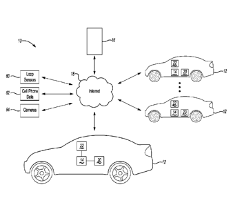
[0022] Figure 1 schematically illustrates a traffic profiling system
10. A vehicle 12
includes an onboard traffic conditions computer 14 (hereinafter "onboard
device"). In one
example the onboard device 14 includes some or all of the features in the
commercially available
iLane product (see hwww.ilane.com) and/or the commercially available
DriveSync product
(see www.drivesync.com). A server 16 is operable to communicate wirelessly
with the onboard
device 14 via a wide-area network, such as the Internet 18, or a private
network or channel.
Similar onboard devices 14 are installed on numerous vehicles 12 in the same
geographic area
and also communicate with the server 16. The server 16 may also receive
traffic information
from loop sensors 60, cell phone data 62, cameras 64 or other known sources of
traffic
information, which can be fused with information from the onboard devices 14.
[0023] The onboard device 14 is schematically illustrated in greater
detail in Figure
2. The onboard device 14 includes a road database 44 and a speed limit
database 46 indicating
speed limits on the road segments in the road database 44. The road database
44 and speed limit
database 46 may be pre-stored on the onboard device 14 or downloaded and/or
updated from the
server 16. If the road database 44 and speed limit database 46 are downloaded
and/or updated
from the server 16, they may be downloaded and/or updated only for roads in
the vicinity of the
vehicle 12. The vicinity may be defined as an area around the vehicle 12 which
is set to be
dependent on density of roads and density of populations (e.g., the higher the
density the smaller
is the area).
3
CA 02864877 2014-08-18
WO 2013/123512 PCT/US2013/026728
[0024] The onboard device 14 includes a processor 52 and storage for
storing the data
and programs to perform the functions described herein. The onboard device 14
may include a
GPS receiver 48, or may receive GPS location from a cell phone or other mobile
device 22
(Figure 1). The onboard device 14 includes an OBD port 50 for receiving on-
board diagnostic
information from an OBD port (or OBD-II or any other protocol) on the vehicle
12. A mobile
device communication module 40 provides wireless (or alternatively, wired)
communication
with the mobile device 22 to provide communication to the server 16 and to
obtain information
from the mobile device 22 itself (contacts, email, GPS location information,
etc). The onboard
device 14 may also include one or more wireless transceivers 54 to communicate
directly with
cell towers to access the Internet 18 and/or with wireless transceivers 54 on
other vehicles 12.
The onboard device 14 further includes a microphone 56 for receiving voice
commands from a
user and a speaker 58 for giving audible information to the user. The speaker
58 could
alternatively be part of the vehicle 12 audio system. The onboard device 14
preferably
communicates with the user primarily via voice, although a display output
module 38 for sending
information to a display 20 could also be provided. Thus, the onboard device
14 includes a
speech recognition module 34 and a text-to-speech module 36.
[0025] Although the vehicle 12 is illustrated as being an automobile,
it is understood
that the onboard device 14 could be applied to other vehicles too, such as
motorcycles, bicycles,
etc.
[0026] Since the onboard device 14 may be used by a vehicle operator
(e.g. a driver),
by a vehicle passenger (e.g. limousine passenger), or by another party, the
term "user" will be
used to refer to a person interacting with the onboard device 14.
[0027] The onboard device 14 provides the server 16 with at least the
following
information: Vehicle location and speed in real time, fuel level, vehicle
health report, land
duration of idle time, time of travel, length of travel time along travelled
road segments, average
speed on each travelled road segment, and location points on road segments
where vehicle speed
changes significantly (speed inflection points).
4
CA 02864877 2014-08-18
WO 2013/123512 PCT/US2013/026728
[0028] Localized Assessment
[0029] The system 10 determines its location relative to the database
of roads 44
based upon (for example) the GNSS based location information and then obtains
the current
speed limit of the current road segment from the speed limit database 46. The
onboard device 14
determines its current speed based upon information from a GNSS system 48
and/or from the
speed information available on the OBD 50 and/or from an accelerometer on the
onboard device
14. The onboard device 14 compares the current speed limit with the current
estimated speed of
the vehicle 12, and computes a traffic condition index based on the comparison
of speed with the
speed limit, and indexed to position, as shown in Figure 3. The index is one
of a number of
traffic condition classes (see, e.g., Fig. 3). If at the time the traffic
index matches some traffic
conditions criteria, a spatio-temporal profile of the traffic index is
transmitted to the server 16.
For example, if the index indicated the presence of traffic congestion, then a
message is sent to
the server 16 indicating a traffic congestion event along with the profile.
The message includes
the time, road segment, location and current speed.
[0030] Thus, the onboard device 14 is operable to perform a "localized
assessment"
on the vehicle 12 of traffic (e.g., comparing a speed limit to a current
vehicle speed).
[0031] Cooperative Assessment
[0032] The onboard device 14 is responsive to voice commands via
speech
recognition module 34 (see Fig. 2). In one example, a user who recognizes a
traffic congestion
event can choose to send a traffic profile report alert to the server 16 by
using a voice command
to tell the onboard device 14 to send a traffic report alert to the server 16
in the form of a natural
language sentence such as "very heavy road congestion," "congestion due to an
accident,"
"congestion due to slippery conditions," etc. The onboard device 14 will send
the sentence along
with a time and a location of the vehicle 12.
[0033] In this example, the server 16 parses the sentences it receives
to estimate the
traffic condition in and around the reported location of the report. An
algorithm at the server 16
is used to process the parsed sentences to compute a traffic conditions
profile throughout the
road network and to determine and eliminate outlier reports or incorrect
reports. A similar
CA 02864877 2014-08-18
WO 2013/123512 PCT/US2013/026728
algorithm may be used to process the traffic condition indices in the
"Localized Assessment"
section above.
[0034] Thus, the onboard device 14 is also operable to perform a
"cooperative
assessment" because there is some interaction or discourse between the onboard
device 12 and
the user to assess traffic conditions.
[0035] User-driven traffic reports are qualified based on historical
accuracy of the
given user and consistency across multiple inputs before use across the
broader population. This
is important to minimize the impact of malicious inputs on the quality of the
overall cooperative
assessment, and isolate the influence of this user.
[0036] Merging of Traffic Data from Multiple Sources
[0037] Whenever possible, the server 16 may fuse the parsed sentences
from many
users for the area and reported indices from many vehicles 12 for the area to
compute a reliable
and explainable traffic condition for a traffic segment, leading to
determination of the traffic
conditions in the area. Furthermore, this information may be fused with
traffic data obtained
from other sources, such as loop sensors 60, cameras 64, and cellular-mobility
data 62. Such
diverse multi-source reports allow for high confidence and more accurate
traffic conditions
estimation. The server 6 may process parsed sentences (the cooperative
assessments) and indices
(the localized assessments) collected from multiple vehicles 12 to establish
time and contextual
statistical traffic record for an area, and to ensure accuracy of traffic
data.
6
CA 02864877 2014-08-18
WO 2013/123512 PCT/US2013/026728
[0038] Congestion-Based Routing of Multiple Vehicles
[0039] Traffic, weather, and related information may be selectively
delivered to each
vehicle to optimize the overall flow of traffic in aggregate, rather than
optimizing the route of
one vehicle at a time. This approach ensures traffic is rerouted across
multiple alternate routes in
a balanced fashion to minimize the probability of a secondary congestion off
of the primary
route.
[0040] Vehicles with known relationships (common fleet, related
vehicles, etc.) may
be routed as a single unit and not distributed across multiple paths to help
minimize confusion.
[0041] Road Condition Inquiries from Onboard Device
[0042] The onboard device 14 can send inquiries about road conditions
on a certain
road segment to the server 16. Based on the processed reported sentences and
indices received
from multiple vehicles 12, the server 16 can send the inquirer a response
indicating the traffic
condition of the area. Also, in this case other traffic profiling data from
cellular and loop sensors
may be used to compose a report. If no report or index is available for the
area then a message is
sent to the onboard device 14 indicating such condition (e.g., a "no incident"
or "no data
available" response is sent to the onboard device 14). The onboard device 14
conveys the
information to the operator of the vehicle 12 using voice (using Text to
Speech module 36 in Fig.
2) or congestion color code road map on a display 20 (using Display Output
module 38 in Fig.
2). Of course, other reporting methods would be possible. This information may
also be reported
on a web portal for viewing (e.g. on the display 20).
[0043] Selective Transmission of Traffic Alerts
[0044] The server 16 may receive traffic condition reports from many
vehicles 12,
and the server 16 continuously processes those reports to determine traffic
alerts. Onboard
devices 14 may be used to navigate the user via a calculated route to a
destination, such that the
current location and destination are easily known.
[0045] Alternatively, even without navigation, the destination of the
vehicle 12 may
otherwise be known or may be deduced (e.g. based upon driving patterns, such
as driving home
after work on weekdays). For example, first, the destination and even (if
necessary) the current
location can be scheduled or can be deduced.
7
CA 02864877 2014-08-18
WO 2013/123512 PCT/US2013/026728
[0046] A user can a user-friendly user interface (such as by accessing
the server 16
via the internet 18) to define a path (or at least an origin and destination)
on a map and time of
day window of interest (e.g, 4:00PM and 6:00PM on weekdays), and trip time
tolerance for the
path, and Latest time of arrival (LTA). The user can also associate a contact
(from mobile
device 22) that is relevant to the path.
[0047] Alternatively, the server 16 (and/or onboard device 14 and/or
mobile device
22) can deduce the user current path and destination based upon driving
history. For example, if
user tends to be in location A first in the day and in location B later in the
day, the system will
deduce based on the time window the start of the trip and the end of the trip,
and hence can
deduce relevant traffic flow. For example, if the user normally commutes from
Toronto to
Waterloo in the morning and back from Waterloo to Toronto later in the day,
the system will
report westbound traffic conditions in the morning and eastbound traffic
conditions later in the
day- depending on the time of day window. The user can always be more specific
on a path
entry so as to inform the system the start of the path and the end of the
path, and as such the
system can deduce the relevant traffic flow.
[0048] The server 16 determines the vehicles 12 that are affected by
the alert (based
upon their current locations and based upon the known or assumed destinations)
and sends the
alerts to those affected vehicles. Additionally, or alternatively, where the
destination is not
known, road segments in the area in the direction that the vehicle 12 is
heading are considered
relevant. For example, based on destination and location of vehicle 12, an
alert may be sent to
the vehicle 12. Vehicles not affected by the condition are not bothered and
the server 16 may
choose to not even send the report to those vehicles.
[0049] The system will insert this information from the user
information in a stack
that is time of day indexed. When the system day timer approaches the start of
the time window
the system computes a traffic condition report along the path that was
introduced by the user.
The system will use the current location (from user GPS unit or cell phone
location) of the user
to deduce traffic flow direction to be relevant to the user (e.g., east bound
vs west bound). If the
user location information is not available then the system may use historical
information on user
mobility to deduce user location based on the time.
8
CA 02864877 2014-08-18
WO 2013/123512 PCT/US2013/026728
[0050] The user can enter to the system a trip time tolerance value.
The system will
use this time tolerance to compute a threshold for the alert. For example, the
user may indicate to
the system that his/her trip time tolerance for the path is a certain length
of time, e.g. 20 minutes.
In this case the system will compute trip time for the path, and compares that
to the trip time of
the path under normal traffic conditions. If the computed trip time for the
path is different from
the trip time of the path under normal traffic conditions by more than 20
minutes, then the
system will send an alert, otherwise no alert is sent. Alternatively, the time
tolerance can be
expressed in terms of a percent of normal travel time (e.g. send an alert if
travel time will
increase more than 10% over the normal travel time).
[0051] The user can enter the path information via the system web site
or by
composing a message (such as a properly formatted email, text message, etc) to
the server 16.
The system can parse the message to determine the relevant information, such
as path start, path
end, LTA, LTD, Contact, Tolerance, etc.
[0052] As an alternative, instead of generating alerts based upon a
time frame, the
alert session can be initiated as soon as it is determined that the car is on
or approaching the path
to the destination. Further, if the user does not enter a specific path, the
system will deduce paths
relevant to the user distinction, based on historical driving behavior of the
user around the time
frame of travel and or best paths possible.
[0053] A "path-relevant contact" could be home, office, friend,
colleague, a meeting
party, etc., that is a contact on the user's mobile device 22. The system can
deduce a path-
relevant contact from the user's calendar. If there exists a calendar event
(e.g. on the mobile
device 22) that coincides with the estimated time of arrival and/or a calendar
event the location
of which is in the vicinity of the user destination then all participants in
the calendar event
(meeting parties, or destination contact) may be sent an alert (e.g. if the
user is going to be late)
to all or some of the participants in the meeting or the contact person
associated with the
destination (for example, if the destination address matches a contact in the
user's contacts).
[0054] The system acquires incident reports on the road network for
example by
connecting to a road management entity a government road management entity.
The system
matches reported incidents to the user paths of travel. Once an incident is
detected it is
9
CA 02864877 2014-08-18
WO 2013/123512 PCT/US2013/026728
continuously monitored to estimate severity and persistence of impact on trip
time along the
paths. The system will alert the user on the incident and provide linguistic
description on the
incident such as where, how long is the traffic jam due to the incident, and
suggest alternative
routing if possible.
[0055] The user informs the system (e.g. server 16 and/or mobile
device 22) that the
user intends to go to a destination and would like to be at destination by a
certain time. The
system can also deduce this information from monitoring the user's travel
trends and history. For
example, the system observes that the user makes daily trips to arrive at
destination around 7PM.
The agent uses 7PM as a target arrival time and plans the trip in terms of
best path and trip
starting time so that the user will arrive at the destination at 7PM. The
system uses real-time path
planning system to propose trip starting time based on its knowledge of the
traffic conditions.
This knowledge is derived from historical data, current traffic conditions,
and information
provided by other agents. The user can use attributes such as (critical
arrival time, flexible
arrival time, and not-before arrival time, etc) to describe his planned
arrival time at the
destination. This information is used by the system to perform multi-criteria
optimization
calculation to balance distance traveled, time traveled, and total idle time.
[0056] Trip Time Computation
[0057] If a vehicle 12 operated has programmed with a destination into
the onboard
device 14 or the server 16, then the trip time to the destination may be
computed based on
routing data and traffic conditions on the route. The onboard unit 14 or the
server 16 determine a
sequence of road segments, which can be computed onboard or can be obtained
from a generic
routing service provider such as MapQuest. The onboard unit 14 or the server
16 then checks if a
road segment is affected by a congestion situation. If a segment is determined
to be affected by a
traffic congestion event, the travel time for the segment may be recomputed
and the trip time to
destination may be updated, and the user may be informed of the updated trip
time (e.g. via Text
to Speech module 36). Alternatively, if a segment on the route is determined
to be affected by a
traffic congestion event, then the route can be recalculated to avoid the
congested segment.
CA 02864877 2014-08-18
WO 2013/123512 PCT/US2013/026728
[0058] Timed Event Functionality
[0059] If the user programs a timed event (e.g. such as a meeting, can
be fetched
from calendar on mobile device 22), the onboard device 14 may provide a proper
warning on the
possibility of missing the meeting (e.g. providing a computer generated speech
message to the
user). The onboard device 14 may offer to call the meeting inviter to allow
the user to notify the
meeting inviter of a possible delay, or may offer to transmit an email message
or a text message
to the user to provide the notification. The call, email, or text message may
be performed using a
mobile device 22 that the onboard device 14 communicates with via Mobile
Device
Communication module 40.
[0060] The onboard device 14 may suggest to the user a superior route
to the
destination that would exhibit less traffic. Thus, the onboard device 14 may
perform a less traffic
congestion routing feature.
[0061] If the user enters a meeting location and time in his mobile
device 22 or office
computer calendar, the system 10 will continue to monitor traffic conditions
that affect the roads
between the user's current location and that where the meeting will take
place. If the onboard
device 14 or server 16 determine that a difference between the present time
and that when the
meeting will take place is becoming critically tight for the user to travel to
the meeting place, a
warning may be sent to the user on his computer or mobile phone 22 to warn
him/her that timing
is getting tight for them to make it to the meeting. The user can add some
safety factors in the
form of extra time (e.g., if it takes 2 hours to travel to the meeting place,
and the difference
between the present time and the meeting starting time is 2 hours, the user
may ask the system to
allow for 30 minutes extra, and the system 10 may provide the warning 30
minutes before the
present time).
[0062] The system uses the LTA and computed traffic conditions to
determine the
latest time of departure (LTD) for the user. The user is sent an alert x
minutes before the LTD to
inform the user that he/she need to leave in x minutes to make it to the
destination on time
(LTA). If during travel time on the path the system determines that LTA is
unachievable a
revised ETA (estimated time of arrival) is computed and the user is informed
of the revised ETA.
The system will offer to connect the user to the path relevant contact so that
the user can inform
11
CA 02864877 2014-08-18
WO 2013/123512 PCT/US2013/026728
them of travel delay. Alternatively, the system can send an alert to the path
relevant contact to
inform them of a delay the user is experiencing due to traffic conditions and
the revised ETA.
Optionally, the system will mark the current location of the user on a map and
present the map to
the path relevant contact.
[0063] Information Sharing
[0064] In addition to uploading a traffic profile report to the server
16, the system 10
may use short range communication capabilities of the transceiver 54 of the
onboard device 14 to
broadcast to vehicles in its vicinity the presence of traffic congestion.
Thus, in one example,
traffic information may be shared directly between onboard devices 14 in
vehicles within a
predefined proximity to each other. Alternatively, the information could be
transmitted via the
Internet or even via the server 16 (although, without filtering or fusion with
other sources)
between other onboard devices 14 within a radius of one another.
[0065] Information Weighting
[0066] Since the server 16 receives information about traffic from
multiple vehicles
12 and other sensors 60, 62, 64, the server 16 may assign weights of evidence
to the different
sources and combine the information from the different sources and assign a
weight of evidence
(or confidence factor) on the traffic condition.
[0067] Abstraction of Traffic Conditions
[0068] In one example, the system 10 employs multi-level abstraction
of traffic
conditions of a road segment that ranges from numerical traffic data such as
speed (e.g., "Current
speed on road segment is 70 km/hour") to linguistic natural language traffic
descriptors (e.g.,
"Traffic condition on the road segment is very slow"). A Fuzzy Logic Engine 42
(see Fig. 2)
may be used to produce linguistic traffic descriptors from speed range
measurements.
[0069] The Fuzzy Engine 42 allows the user to discourse with the
onboard device 14
inquire about the traffic conditions. For example, the user can ask questions
such as traffic
conditions on current road on which the vehicle is being driven. The system 10
will scan the road
and report using natural language traffic conditions at high level (e.g.
"traffic is slow," or
"somehow slow," or "very slow," or "smooth on a road segment"). The user can
ask questions to
the onboard device 14 (e.g., "Tell me traffic conditions on east bound," "Tell
me traffic
12
CA 02864877 2014-08-18
WO 2013/123512 PCT/US2013/026728
conditions on north bound," etc.). The onboard device 14 can take the name of
a road uttered via
voice by the user to a segment on the road or the whole road. For example, the
system can
determine based on vehicle location the interpretation of east bound relative
to the vehicle
location. That is, the system 10 can use the location and/or direction of
vehicle 12 movement to
determine relevant segment of the road that the user is interested in. The
user can ask the system
to provide more detailed information (e.g. by asking "How slow?"). Where the
system 10
provides a current speed range on the segment (e.g., "Traffic is moving with
speed between 40 to
50 km an hour"), the user can ask a question in response (e.g. "How bad is
traffic on the
segment?). The system 10 can answer with a speed range and possible a duration
for which that
speed range has been experienced by other users. The system can also say speed
is starting to
pick up. The user can set an alert flag, such that the system 10 will monitor
traffic on the trip
path and report emerging deteriorating/improving traffic conditions.
[0070] Based on the computed traffic assessment for a given user, the
system
composes a sequence of report to the user.
[0071] If the system determines that the traffic conditions are normal
then a "normal
condition" alert is sent to the user. No more alerts are sent until the
traffic condition state has
changed. The amount of change to trigger a report subsequent to the first
"normal condition" is
computed based on the persisting nature traffic flow variation. For example a
traffic flow change
in a small 100 meters segment on the road is ignored unless it persists in way
such that its
extends on the path to cover more 500 meters. Only then the system will send
an alert to the user
to inform him/her that traffic starts to worsen on his/her entered path. The
system will use
street/road names and land marks to localize the traffic alert to the user.
For example, the system
will send an alert such as "very slow traffic on HW 401, between Exit x and
Exit y". It can also
say "very slow traffic on King street just after Fairway Shopping Mall, Or
exit into to Fairway
shopping mall".
[0072] The system uses a fuzzy engine to translate traffic conditions
data to linguistic
traffic conditions indicators. Furthermore, the system uses an Artificial
Neural Network to map
current and historical traffic patterns to predicted traffic conditions along
the path. These
13
CA 02864877 2014-08-18
WO 2013/123512 PCT/US2013/026728
predictions can be used by the system to be more proactive in its alert
announcement and traffic
condition persistence profiling which is used to compute an alert threshold.
[0073] Multi-agent software architecture
[0074] A multi-agent software architecture may be used to implement
the system
where by each user is assigned a software agent, such as in the mobile device
22 (alternatively,
on the onboard device 14 or even on the server 16). The agent is the one that
monitors on behalf
of the user the traffic conditions that could potentially affect his/her trip
time. The agent also
performs the alert regime above. Furthermore, user can choose to enlist in a
group of commuters,
for example, daily Toronto-Waterloo commuters, weekly Waterloo-Toronto
commuters, etc. The
agents assigned to these users cooperate to exchange information about traffic
and incidents. An
agent that discovers a traffic incident such as an accident or congestion will
broadcast
information about the incident to agents in the group according to the rules
set by the user to the
broadcasting agent (e.g., inform agents within a certain range of the
incident, agents of
commuters who are approaching the incident, agents of commuters who happen to
be in a certain
geographical area, and/or agent who have reported travel paths that are
affected by the incident).
The recipient agent uses a set of rules personalized by the user to decide
whether to inform its
user or not (e.g. only if a certain number of agents reported the incident,
only if its user is in the
car, only if its user enabled the agent-to-agent traffic information
exchange.) In this manner, the
system could be run solely on the mobile devices 22, with little or no
collection or analysis of
data by the server 16.
[0075] User agents fuse information to compute statistical information
on travel time
for traveled paths. These statistics include, but not limited to, max travel
time, min travel time,
average travel time, probability of max time, probability of min travel time,
variance. Agents are
given weights based on how many paths they have processed. An agent that has
monitored a
road segment or travel path more frequently is given more weigh in the
calculation that an agent
who monitored the road segment or travel path less frequent.
14
CA 02864877 2014-08-18
WO 2013/123512 PCT/US2013/026728
[0076] Driver-centric information system
[0077] The server 16 also uses the information from the onboard device
14 to
compute the following, which can be viewed by the user on display 20, or on a
computer, tablet
or smart phone accessing a website hosted on the server 16.
a. Travelled routes (travelled is a path between the start of a trip and
the end of a
trip). For example, Figure 4 is an example table that can be displayed to the
user showing the
number of times each route was travelled, where each route is identified by an
origin and a
destination. A route number or identifier is assigned to each route, because a
different route may
have been taken between the same origin and destination. The number of trips
on the route
refers to a specific route between that origin and destination. An alternative
route to frequent
destinations may be suggested, as in Figure 6.
b. Correlate idle time with traffic light and stop sign location to
estimate average
traffic light timing and average waiting time on a stop sign.
c. Rank routes in frequency of travel by the user. (Figure 4). Rank
destinations in
frequency by the user. (Figure 5)
d. For routes between similar or identical start and end points compute
ranking on
travel time, and idle time, average speed. (Figure 4).
e. Center a map of the area around the present location of the vehicle, and
plot
routes from the location of the vehicle to frequent destinations, along with
current traffic
conditions of each route. This is shown in Figure 7, where routes to three
frequent destinations
(for example), with the thickness of each line corresponding to traffic levels
(in the commercial
embodiment, colors would be used to indicate traffic levels, such as red or
green, instead of line
thickness.
f. Center a map of the area around the present location of the vehicle and
plot a
color coded traffic map to show traffic condition in the vicinity of the car.
g. Based on the location of the vehicle display weather forecast
information for the
area around the location of the vehicle.
h. Search for weather related alerts and traffic related alerts for the
area where the
vehicle is located and display them on the map.
CA 02864877 2014-08-18
WO 2013/123512 PCT/US2013/026728
i. For each frequent route compute safety index based on routes' accident
history,
number of lanes, weather conditions at the time, and time of the day.
j. For each frequently travelled route show average speed, idle time,
travel time,
number of traffic lights and stop signs, longest wait stop sign, and longest
wait traffic light.
k. Compute alternative routes to the frequently travelled routes if other
routes exist
that will the user travel time, idle time, fuel, etc.
1.
Determine events of interest on routes and present to the user so that he/she
can
avoid them if they are unwanted (construction, accidents, weather hazards,
strikes, etc), or
consider them if they are attractive (for example, promotions, discount
events, cheaper gas, or
scenic).
m.
The routing algorithm will use the data for the routes of the user in
recommending
better routes and new routes.
[0078]
The server 16 combines the above information from a number of users
(onboard devices 14) to compute a map of travelled routes and populate the map
with stop signs
and traffic lights.
[0079]
The server 16 populates the routes on the map with speed data (average speed,
speed inflection point). This allows a user to open the map to view routes.
The user can query
timing of a stop sign or a traffic light. The user can create a path and
compute total travel time
and average speed, and expected waiting time due to stops and traffic lights
on the path. The
server 16 can estimate frequency of use per route during time slots of the day
based on
information from all users of the route. For users who have similar frequent
travel routes allow
exchange of route tips that can help another user save time, fuel, reduce idle
time and increase
safety. The server 16 uses this amalgamated information to enable computing
routing
recommendations of users.
[0080]
The user will be presented a weather map centered around his last car reported
location (i.e. the last location of the onboard device). The server 16 will
send him weather alerts
if they are relevant to him based on his location. Routes are classified based
on:
a. Zip code to zip code
b. City to city
16
CA 02864877 2014-08-18
WO 2013/123512 PCT/US2013/026728
c. Address to address.
The system will deduce zip code, address and city of residence based on user
mobility patterns.
The user will be presented weekly, and monthly, yearly use averages for city
to city, address to
address, and zip code to zip code. Moreover, it calculates trips made to
shopping malls, gas
stations, any other public places.
[0081] Although a preferred embodiment of this invention has been
disclosed, a
worker of ordinary skill in this art would recognize that certain
modifications would come within
the scope of this invention. For that reason, the following claims should be
studied to determine
the true scope and content of this invention.
17