Note: Descriptions are shown in the official language in which they were submitted.
1
CONTROL SYSTEM FOR WORK VEHICLE, METIIOD FOR SETTING TRAJECTORY OF
WORK IMPLEMENT, AND WORK VEHICLE
BACKGROUND OF THE INVENTION
Field of the Invention
[0001] The present invention relates to a control system for a work vehicle, a
method for setting
the trajectory of a work implement, and a work vehicle.
Description of the Related Art
[0002] A system for a bulldozer, a grader, or another such work vehicle has
been proposed in the
113 past in which, in order to carry out work more efficiently, a target
profile by which a work
implement is to operate at the work site is preset from the terrain at the
work site, and the work
implement is operated according to this target profile.
CITATION LIST
PATENT LITERATURE
[0003] Patent Literature 1: U.S. Patent No. 8,639,393
SUMMARY OF THE INVENTION
PROBLEM TO BE SOLVED BY THE INVENTION
[0004] With the above-mentioned conventional system, even an inexperienced
operator can
perform work efficiently. With this conventional system, however, the work
implement cannot
necessarily be operated according to the target profile. For instance, the
work vehicle may deviate
from the intended path due to the properties of the soil, the gradient of the
work site, and other such
1
CA 2991840 2018-02-21
, 2
factors. In that case, work according to the target profile on route that
differs from the planned
route may not be efficient.
[0005] It is an object of the present invention to solve the above problem.
MEANS FOR SOLVING PROBLEM
[0006] A first aspect is a control system for a work vehicle including a work
implement. The
control system includes a controller. The controller is programmed to execute
the following
processing. The controller acquires the travel direction of the work vehicle.
The controller
acquires current terrain data indicating the current terrain existing in the
travel direction of the
work vehicle. The controller decides on a target profile of a work site based
on the current terrain
data. The controller generates a command signal for operating the work
implement according to
the target profile. The controller updates the travel direction of the work
vehicle. The controller
updates the target profile based on the updated travel direction.
[0007] A second aspect is a method for setting the trajectory of a work
implement of a work
vehicle. The method includes the following processing. The first processing is
to acquire the travel
direction of the work vehicle. The second processing is to acquire current
terrain data indicating
the current terrain existing in the travel direction of the work vehicle. The
third processing is to
decide on a target profile of a work site based on the current terrain data.
The fourth processing is
to update the travel direction of the work vehicle. The fifth processing is to
update the target profile
based on the updated travel direction.
[0008] A third aspect is a work vehicle including a work implement and a
controller. The
controller is programmed to execute the following processing. The controller
acquires the travel
2
CA 2991840 2018-02-21
3
direction of the work vehicle. The controller acquires current terrain data
indicating the current
terrain existing in the travel direction of the work vehicle. The controller
decides on a target profile
of a work site based on the current terrain data. The controller generates a
command signal for
operating the work implement according to the target profile. The controller
updates the travel
direction of the work vehicle. The controller updates the target profile based
on the updated travel
direction.
EFFECTS OF THE INVENTION
[0009] With the present invention, a work vehicle can be made to perform work
more efficiently
and with good finish quality under automatic control.
BRIEF DESCRIPTION OF DRAWINGS
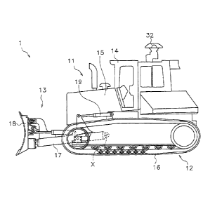
[0010] FIG. 1 is a side view of a work vehicle pertaining to an embodiment;
FIG. 2 is a block diagram of the configuration of the drive system and control
system of the
work vehicle;
FIG. 3 is a simplified diagram of the configuration of the work vehicle;
FIG. 4 is a flowchart of processing in the automatic control of a work
implement;
FIG. 5 is a graph showing an example of a final design terrain, a current
terrain, and a target
design terrain;
FIG. 6 is a diagram showing an example of work site terrain data;
FIG. 7 is a graph showing an example of target displacement data;
FIG. 8 is a flowchart of the processing for deciding a target displacement;
3
CA 2991840 2018-02-21
, 4
FIG. 9 is a graph showing an example of an updated final design terrain,
current terrain, and
target design terrain;
FIG. 10 is a block diagram of the configuration of a control system pertaining
to a first
modification example;
FIG. 11 is a block diagram of the configuration of a control system pertaining
to a second
modification example;
FIG. 12 is a graph showing an example of target load parameter data;
FIG. 13 is a graph showing another example of a target design terrain; and
FIG. 14 is a diagram of digging work according to prior art.
DETAILED DESCRIPTION OF THE INVENTION
[0011] The work vehicle pertaining to an embodiment will now be described
through reference to
the drawings. FIG. 1 is a side view of the work vehicle 1 according to an
embodiment. The work
vehicle 1 in this embodiment is a bulldozer. The work vehicle 1 includes a
vehicle body 11, a drive
unit 12, and a work implement 13.
[0012] The vehicle body 11 has a cab 14 and an engine compartment 15. A
driver's seat (not
shown) is disposed in the cab 14. The engine compartment 15 is disposed in
front of the cab 14.
The drive unit 12 is attached to the lower portion of the vehicle body 11. The
drive unit 12 has a
pair of right and left crawler belts 16. Only the left crawler belt 16 is
shown in FIG. 1. Rotation of
the crawler belts 16 propels the work vehicle 1. The travel of the work
vehicle 1 may be either
autonomous travel, semi-autonomous travel, or travel under operation by the
operator.
4
CA 2991840 2018-02-21
5
[0013] The work implement 13 is attached to the vehicle body 11. The work
implement 13 has a
lift frame 17, a blade 18, and a lift cylinder 19.
[0014] The lift frame 17 is attached to the vehicle body 11 so as to be
movable up and down
around an axis X extending in the vehicle width direction. The lift frame 17
supports the blade 18.
The blade 18 is disposed in front of the vehicle body 11. The blade 18 moves
up and down as the
lift frame 17 moves up and down.
[0015] The lift cylinder 19 is linked to the vehicle body 11 and the lift
frame 17. As the lift
cylinder 19 expands and contracts, the lift frame 17 rotates up and down
around the axis X.
[0016] FIG. 2 is a block diagram of the configuration of the drive system 2
and the control system
3 of the work vehicle 1. As shown in FIG. 2, the drive system 2 includes an
engine 22, a hydraulic
pump 23, and a power transmission device 24.
[0017] The hydraulic pump 23 is driven by the engine 22 and discharges
hydraulic fluid. The
hydraulic fluid discharged from the hydraulic pump 23 is supplied to the lift
cylinder 19. In FIG. 2,
just one hydraulic pump 23 is shown, but a plurality of hydraulic pumps may be
provided.
[0018] The power transmission device 24 transmits the drive force of the
engine 22 to the drive
unit 12. The power transmission device 24 may be, for example, a hydro-static
transmission (HST).
Alternatively, the power transmission device 24 may be, for example, a torque
converter or a
transmission having a plurality of gears.
[0019] The control system 3 includes an operating device 25a, a controller 26,
a storage device 28,
and a control valve 27. The operating device 25a is used to operate the work
implement 13 and the
drive unit 12. The operating device 25a is disposed in the cab 14. The
operating device 25a
5
CA 2991840 2018-02-21
, 6
receives operator inputs for driving the work implement 13 and the drive unit
12, and outputs an
operation signal corresponding to the input. The operating device 25a
includes, for example, a
control lever, a pedal, a switch, or the like.
[00201 For example, the operating device 25a for the drive unit 12 is provided
to allow for
operation in a forward position, a reverse position, and a neutral position.
An operation signal
indicating the position of the operating device 25a is outputted to the
controller 26. When the
operation position of the operating device 25a is the forward position, the
controller 26 controls the
drive unit 12 or the power transmission device 24 so that the work vehicle 1
moves forward. When
the operating position of the operating device 25a is the reverse position,
the controller 26 controls
the drive unit 12 or the power transmission device 24 so that the work vehicle
1 moves backward.
100211 The controller 26 is programmed to control the work vehicle 1 on the
basis of acquired
data. The controller 26 includes a processing device (processor) such as a
CPU, for example. The
controller 26 acquires an operation signal from the operating device 25a. The
controller 26 controls
the control valve 27 on the basis of the operation signal. The controller 26
is not limited to a single
unit, and may be divided up into a plurality of controllers.
[00221 The control valve 27 is a proportional control valve and is controlled
by a command signal
from the controller 26. The control valve 27 is disposed between the hydraulic
pump 23 and a
hydraulic actuator such as the lift cylinder 19. The control valve 27 controls
the flow of hydraulic
fluid supplied from the hydraulic pump 23 to the lift cylinder 19. The
controller 26 generates a
command signal to the control valve 27 so that the blade 18 operates according
to the operation of
the operating device 25a discussed above. Consequently, the lift cylinder 19
is controlled
6
CA 2991840 2018-02-21
, 7
according to the operation amount of the operating device 25a. The control
valve 27 may be a
pressure proportional control valve. Alternatively, the control valve 27 may
be an electromagnetic
proportional control valve.
[0023] The control system 3 includes a lift cylinder sensor 29. The lift
cylinder sensor 29 senses
the stroke length of the lift cylinder 19 (hereinafter referred to as "lift
cylinder length L"). As
shown in FIG. 3, the controller 26 calculates the lift angle OM of the blade
18 on the basis of the
lift cylinder length L. FIG. 3 is a simplified diagram of the configuration of
the work vehicle 1.
[0024] In FIG. 3, the origin position of the work implement 13 is indicated by
a two-dot chain
line. The origin position of the work implement 13 is the position of the
blade 18 in a state in
which the cutting edge of the blade 18 is in contact with the ground on a
horizontal surface. The
lift angle Olift is the angle of the work implement 13 from the origin
position.
[0025] As shown in FIG. 2, the control system 3 includes a position sensing
device 31. The
position sensing device 31 measures the position of the work vehicle 1. The
position sensing
device 31 includes a GNSS (global navigation satellite system) receiver 32 and
an IMU 33. The
GNSS receiver 32 is, for example, a GPS (global positioning system) receiver.
The antenna of the
GNSS receiver 32 is disposed on the cab 14. The GNSS receiver 32 receives
positioning signals
from a satellite and calculates the position of the antenna based on the
positioning signal to generate
vehicle position data. The controller 26 acquires vehicle position data from
the GNSS receiver 32.
The controller 26 obtains the travel direction and speed of the work vehicle 1
by using the vehicle
position data.
7
CA 2991840 2018-02-21
8
[0026] The [MU 33 is an inertial measurement unit. The IMU 33 acquires vehicle
inclination
angle data. The vehicle inclination angle data includes the angle of the
vehicle longitudinal
direction with respect to the horizontal (pitch angle), and the angle of the
vehicle lateral direction
with respect to the horizontal (roll angle). The controller 26 acquires
vehicle inclination angle data
from the IMU 33.
[0027] The controller 26 calculates a cutting edge position PO from the lift
cylinder length L, the
vehicle position data, and the vehicle inclination angle data. As shown in
FIG. 3, the controller 26
calculates the global coordinates of the GNSS receiver 32 based on the vehicle
position data. The
controller 26 calculates the lift angle Olift based on the lift cylinder
length L. The controller 26
calculates the local coordinates of the cutting edge position PO with respect
to the GNSS receiver
32 based on the lift angle Olift and vehicle size data. The vehicle size data
is stored in the storage
device 28 and indicates the position of the work implement 13 with respect to
the GNSS receiver
32. The controller 26 calculates the global coordinates of the cutting edge
position PO based on the
global coordinates of the GNSS receiver 32, the local coordinates of the
cutting edge position PO,
l5 and the vehicle inclination angle data. The controller 26 acquires the
global coordinates of the
cutting edge position PO as cutting edge position data.
[0028] The storage device 28 includes, for example, a memory and an auxiliary
storage device.
The storage device 28 may be, for example, a RAM, a ROM, or the like. The
storage device 28
may be a semiconductor memory, a hard disk, or the like. The storage device 28
is an example of a
non-transitory computer-readable recording medium. The storage device 28
records computer
commands which is executable by a processor for controlling the work vehicle
1.
8
CA 2991840 2018-02-21
.9
[0029J The storage device 28 stores design terrain data and work site terrain
data. The design
terrain data indicates the final design terrain. The final design terrain is
the final target contour of
the surface of the work site. The design terrain data is, for example, an
earthmoving execution plan
in a three-dimensional data format. The work site terrain data indicates the
current terrain at the
work site. The work site terrain data is, for example, a current topographical
survey in a three-
dimensional data format. The work site terrain data can be obtained by aerial
laser survey, for
example.
100301 The controller 26 acquires the current terrain data. The current
terrain data indicates the
current terrain at the work site. The current terrain at the work site is the
terrain of the region along
the travel direction of the work vehicle 1. The current terrain data is
acquired by calculation in the
controller 26 from the work site terrain data and the position and travel
direction of the work
vehicle 1 obtained from the above-mentioned position sensing device 31.
[00311 The controller 26 automatically controls the work implement 13 on the
basis of the current
terrain data, the design terrain data, and the cutting edge position data. The
automatic control of the
work implement 13 may be semi-automatic control performed together with manual
operation by
the operator. Alternatively, the automatic control of the work implement 13
may be fully automatic
control performed without any manual operation by an operator.
100321 The automatic control of the work implement 13 in digging work executed
by the
controller 26 will now be described. FIG. 4 is a flowchart of the processing
involved in automatic
control of the work implement 13 in digging work.
9
CA 2991840 2018-02-21
.10
[0033] As shown in FIG. 4, in step S 101 the controller 26 acquires current
position data. Here,
the controller 26 acquires the current cutting edge position PO of the blade
18 as discussed above.
[0034] In step S102, the controller 26 acquires the travel direction of the
work vehicle 1. Here, as
discussed above, the controller 26 acquires the travel direction of the work
vehicle 1 from the
vehicle position data sensed by the position sensing device 31.
100351 In step S103, the controller 26 acquires the current terrain data. As
shown in FIG. 5, the
design terrain data includes the height Zdesign of the final design terrain 60
at a plurality of
reference points Pn (n = 0, 1, 2, 3, ..., A) in the travel direction of the
work vehicle 1 . The plurality
of reference points Pn indicate a plurality of points at predetermined
intervals along the travel
direction of the work vehicle 1. The plurality of reference points Pn lie on
the travel path of the
blade 18. In FIG. 5, the final design terrain 60 has a flat contour parallel
to the horizontal direction,
but it may have a different contour.
[0036] In step S104, the controller 26 acquires the current terrain data. The
controller 26 acquires
the current terrain data by calculation from the work site terrain data
obtained from the storage
device 28, and the vehicle position data and the travel direction data
obtained from the position
sensing device 31.
100371 The current terrain data is information indicating the terrain located
in the travel direction
of the work vehicle 1. FIG. 5 is a cross section of the current terrain 50. In
FIG. 5, the vertical axis
is the height of the terrain, and the horizontal axis is the distance from the
current position in the
travel direction of the work vehicle I.
CA 2991840 2018-02-21
, 11
[0038] More precisely, the current terrain data includes the height Zn of the
current terrain 50 at a
plurality of reference points Pn up to a specific terrain recognition distance
dA from the current
position in the travel direction of the work vehicle 1. In this embodiment,
the current position is a
position determined on the basis of the current cutting edge position PO of
the work vehicle 1.
However, the current position may be determined on the basis of the current
position of another
part of the work vehicle I. The plurality of reference points are arranged at
specific intervals, such
as every meter.
[0039] FIG. 6 is a diagram showing an example of work site terrain data. The
work site terrain
data divides the current terrain of the work site into a plurality of areas Am
in a grid in a horizontal
to plane, and indicates the height of the current terrain in each area Am.
The size of each square of
the grid, that is, the size of each area Am, is 1 mx 1 m, for example, but is
not limited to this size,
and may be a different one. The work site terrain data indicates the planar
coordinates of the
northerly distance (northing) and the easterly distance (easting) of the
center point Cm of each area
Am, and the height of the current terrain at that center point Cm. In FIG. 6,
only some of the areas
are labeled "Am," and only their center points are labeled "Cm," and the rest
of the areas are not
labeled.
[0040] As shown in FIG. 6, the controller 26 decides a plurality of reference
points Pn located
within a specific distance dA from the cutting edge position PO along the
travel direction H of the
work vehicle 1. The controller 26 then calculates the height Zn of the current
terrain 50 at each
reference point Pn from the height of the current terrain in the area Am
surrounding each reference
point Pn.
11
CA 2991840 2018-02-21
, 12
[0041] For example, the controller 26 calculates the height Zn of the current
terrain 50 at each
reference point Pn by linear interpolation from the height of the current
terrain in the four areas Am
surrounding each reference point Pn. However, the height Zn of the current
landform 50 may be
acquired by a method other than linear interpolation. Consequently, as shown
in FIG. 5, the
controller 26 acquires the height Zn of the current terrain 50 at the
plurality of reference points Pn
along the travel direction of the work vehicle 1 as the current terrain data.
[0042] In step S105 the controller 26 acquires the digging start position. For
example, the
controller 26 acquires the position as the digging start position when the
cutting edge position PO
first drops below the height ZO of the current terrain 50. Consequently, the
position is acquired as
the digging start position, where the cutting edge of the blade 18 is lowered
and digging of the
current terrain 50 is started. However, the controller 26 may acquire the
digging start position by
some other method. For example, the controller 26 may acquire the digging
start position on the
basis of the operation of the operating device 25a. For instance, the
controller 26 may acquire the
digging start position on the basis of the operation of a button, a screen
operation with a touch panel,
etc.
[0043] In step S106 the controller 26 acquires the amount of movement of the
work vehicle 1.
The controller 26 acquires the distance traveled from the digging start
position to the current
position in the travel path of the blade 18 as the amount of movement. The
amount of movement
of the work vehicle 1 may be the amount of movement of the vehicle body 11.
Alternatively, the
amount of movement of the work vehicle 1 may be the amount of movement of the
cutting edge of
the blade 18.
12
CA 2991840 2018-02-21
= 13
[0044] In step S107 the controller 26 decides the target design terrain data.
The target design
terrain data shows the target design terrain 70 indicated by a broken line in
FIG. 5. The target
design terrain 70 indicates the desired trajectory of the cutting edge of the
blade 18 in operation.
The target design terrain 70 is the target profile of the terrain to be
worked, and shows the contour
desired as the result of the digging work.
[0045] As shown in FIG. 5, the controller 26 decides the target design terrain
70 that is displaced
downward from the current terrain 50 by the target displacement Z_offset. The
target displacement
Z_offset is the target displacement in the vertical direction at each
reference point. In this
embodiment, the target displacement Z_offset is the target depth at each
reference point, and
indicates the target position of the blade 18 below the current terrain 50.
The target position of the
blade 18 means the cutting edge position of the blade 18. In other words, the
target displacement
Z_offset indicates the soil volume per unit of movement dug by the blade 18.
Therefore, the target
design terrain data indicates the relation between a plurality of reference
points and a plurality of
target soil volumes. The target displacement Z_offset is an example of a
target load parameter
related to the load on the blade 18.
[0046] The controller 26 decides the target design terrain 70 so as not to go
below the final design
terrain 60. Therefore, the controller 26 decides the target design terrain 70
located at or above the
final design terrain 60 and below the current terrain 50 during digging work.
[0047] More precisely, the controller 26 decides the height Z of the target
design terrain 70
according to the following formula (1).
Formula 1
13
CA 2991840 2018-02-21
. 14
Zn ¨ Z_offset
The target displacement Z_offset is decided by referring to the target
displacement data C.
The target displacement data C is stored in the storage device 28. FIG. 7 is a
diagram showing an
example of the target displacement data C. The target displacement data C
defmes the relation
between the amount of movement n of the work vehicle 1 and the target
displacement Z_offset.
[00481 More precisely, the target displacement data C indicates the digging
depth (target
displacement) Z_offset of the blade 18 in the vertical downward direction from
the ground surface
as a dependent variable of the amount of movement n of the work vehicle 1 in
the horizontal
direction. The amount of movement n of the work vehicle 1 in the horizontal
direction is
substantially the same as the amount of movement of the blade 18 in the
horizontal direction. The
controller 26 decides the target displacement Z_offset from the amount of
movement n of the work
vehicle 1 by referring to the target displacement data C shown in FIG. 7.
[0049] As shown in FIG. 7, the target displacement data C includes data at
start cl, data during
digging c2, data during transition c3, and data during transporting c4. The
data at start cl defines
the relation between the amount of movement n in the digging start region and
the target
displacement Z_offset. The digging start region is the region from the digging
starting point S to
the steady digging starting point D. As indicated by the data at start c 1,
the target displacement
Z_offset that gradually increases according to the increase in the amount of
movement n is defined
in the digging start region. The data at start cl defines the target
displacement Z_offset that linearly
increases with respect to the amount of movement n.
14
CA 2991840 2018-02-21
, 15
[0050] The data during digging c2 defines the relation between the amount of
movement n in the
digging region and the target displacement Z_offset. The digging region is the
region (first region)
from the steady digging starting point D to the transitional transporting
starting point T. As
indicated by the data during digging c2, in the digging region, the target
displacement Z_offset is
defined as a constant value. The data during digging c2 defines a constant
target displacement
Z_offset with respect to the amount of movement n.
[0051] The data during transition c3 defines the relation between the amount
of movement n and
the target displacement Z_offset in the transitional transporting region. The
transitional
transporting region is the region from the steady digging end point T to the
transporting starting
point P. As indicated by the data during transition c3, the target
displacement Z_offset that
gradually decreases according to the increase in the amount of movement n is
defined in the
transitional transporting region. The data during transition c3 defines the
target displacement
Z_offset that linearly decreases with respect to the amount of movement n.
[00521 The data during transporting c4 defines the relation between the amount
of movement n in
the transporting region and the target displacement Z_offset. The transporting
region is the region
(second region) starting from the transporting starting point P. As indicated
by the data during
transporting c4, the target displacement Z_offset is defined as a constant
value in the transporting
region. The data during transporting c4 defines a constant target displacement
Z_offset with
respect to the amount of movement n.
100531 More precisely, the digging region starts at a first start value bl and
ends at a first end
value b2. The transporting region starts at a second start value b3. The first
end value b2 is less
CA 2991840 2018-02-21
16
than the second start value b3. Therefore, the digging region is started when
the amount of
movement n is less than that in the transporting region. The target
displacement Z_offset in the
digging region is constant at a first target value al. The target displacement
Z_offset in the
transporting region is constant at a second target value a2. The first target
value al is greater than
the second target value a2. Therefore, in the digging region, the target
displacement Z_offset is
defined to be greater than in the transporting region.
[0054] The target displacement Z_offset at the digging start position is a
start value a0. The start
value a0 is less than the first target value al. The start target value a0 is
also less than the second
target value a2.
[0055] FIG. 8 is a flowchart showing the processing for deciding the target
displacement Z_offset.
hi order to simplify the description, let us assume that in the decision
processing described below,
the travel of the work vehicle 1 is only forward. The decision processing is
started when the
operating device 25a moves to the forward position. In step S201, the
controller 26 determines
whether the amount of movement n is equal to or greater than 0 and less than
the first start value hi.
When the amount of movement n is equal to or greater than 0 and less than the
first start valuebl,
in step S202 the controller 26 gradually increases the target displacement
Z_offset from the start
value a0 according to the increase in the amount of movement n.
[0056] The start value a0 is a constant and is stored in the storage device
28. It is preferable for
the start value a0 to be small enough that the load on the blade 18 at the
start of digging will not be
excessively high. The first start value bl is found by calculation from the
gradient cl in the digging
start region shown in FIG. 7, the start value a0, and the first target value
al. The gradient cl is a
16
CA 2991840 2018-02-21
. 17
constant and is stored in the storage device 28. It is preferable for the
gradient c Ito be a value at
which it is possible to transition quickly from the digging start to the
digging work, and the load on
the blade 18 will not be excessively high.
[0057] In step S203 the controller 26 determines whether the amount of
movement n is equal to
or greater than the first start value bl and less than the first end value b2.
When the amount of
movement n is equal to or greater than the first start value bl and less than
the first end value b2, in
step S204 the controller 26 sets the target displacement Z_offset to the first
target value al. The
first target value al is a constant and is stored in the storage device 28. It
is preferable for the first
target value al to be a value at which digging can be performed efficiently
and the load on the
blade 18 will not be excessively high.
[0058] In step S205 the controller 26 determines whether the amount of
movement n is equal to
or greater than the first end value b2 and less than the second start value
b3. When the amount of
movement n is equal to or greater than the first end value b2 and less than
the second start value b3,
in step S206 the controller 26 gradually decreases the target displacement
Z_offset from the first
target value al according to the increase in the amount of movement n.
[0059] The first end value b2 is the amount of movement when the current held
soil volume of
the blade 18 is over a specific threshold. Therefore, when the current held
soil volume of the blade
18 goes over a specific threshold, the controller 26 decreases the target
displacement Z_offset from
the first target value al. This specific threshold is decided on the basis of
the maximum capacity of
the blade 18, for example. For instance, the current held soil volume of the
blade 18 may be
decided by measuring the load on the blade 18 and calculating from this load.
Alternatively, the
17
CA 2991840 2018-02-21
18
current held soil volume of the blade 18 may be calculated by using a camera
to capture an image
of the blade 18 and analyzing this image.
100601 At the start of work, a specific initial value is set as the first end
value b2. After the start
of work, the amount of movement when the held soil volume of the blade 18 goes
over a specific
threshold is stored as an update value, and the first end value b2 is updated
on the basis of the
stored update value.
[0061] In step S207 the controller 26 determines whether the amount of
movement n is equal to
or greater than the second start value b3. When the amount of movement n is
equal to or greater
than the second start value b3, in step S208 the controller 26 sets the target
displacement Z_offset
to the second target value a2.
100621 The second target value a2 is a constant and is stored in the storage
device 28. The second
target value a2 is preferably set to a value suitable for transporting work.
The second start value b3
is found by calculation from the gradient c2 in the transporting transfer
region shown in FIG. 7, the
first target value al, and the second target value a2. The gradient c2 is a
constant and is stored in
the storage device 28. It is preferable for the gradient c2 to be a value at
which it is possible to
transition quickly from digging work to transporting work, and the load on the
blade 18 will not be
excessively high.
[0063] The start value a0, the first target value al, and the second target
value a2 may be changed
according to the situation of the work vehicle 1, etc. The first start value
bl, the first end value b2,
and the second start value b3 may be stored in the storage device 28 as
constants.
18
CA 2991840 2018-02-21
19
[00641 As described above, the height Z of the target design terrain 70 is
decided by deciding the
target displacement Z_offset.
[0065] In step S108 shown in FIG. 4, the controller 26 controls the blade 18
toward the target
design terrain 70. Here, the controller 26 generates a command signal to the
work implement 13 so
that the cutting edge position of the blade 18 moves toward the target design
terrain 70 produced in
step S107. The generated command signal is inputted to the control valve 27.
Consequently, the
cutting edge position PO of the work implement 13 moves along the target
design terrain 70.
[0066] In the above-mentioned digging region, the target displacement Z_offset
between the
current terrain 50 and the target design terrain 70 is greater than in other
regions. Consequently, in
the digging region, digging work is performed on the current terrain 50. In
the transporting region,
the target displacement Z_offset between the current terrain 50 and the target
design terrain 70 is
less than in other regions. Consequently, in the transporting region, digging
of the ground surface
is held off, and soil held in the blade 18 is conveyed.
100671 In step S109 the controller 26 updates the work site terrain data. The
controller 26 updates
the work site terrain data with position data indicating the latest trajectory
of the cutting edge
position PO. Alternatively, the controller 26 may calculate the position of
the bottom face of the
crawler belt 16 from the vehicle position data and the vehicle size data, and
update the work site
terrain data with position data indicating the trajectory of the bottom face
of the crawler belt 16. In
this case, the update of the work terrain data can be carried out instantly.
[0068] Alternatively, the work site terrain data may be generated from survey
data measured by a
surveying device outside the work vehicle 1. Aerial laser surveying may be
used as an external
19
CA 2991840 2018-02-21
, 20
surveying device, for example. Alternatively, the current terrain 50 may be
photographed with a
camera, and work site terrain data may be generated from the image data
obtained by the camera.
For example, aerial photographic surveying using a UAV (unmanned aerial
vehicle) may be used.
In the case of an external surveying device or a camera, the work site terrain
data is updated at
specific intervals, or whenever needed.
[0069] The above processing is executed when the work vehicle 1 is moving
forward. For
example, the above processing is executed when the operating device 25a of the
drive unit 12 is in
the forward position. However, if the work vehicle 1 travels in reverse by at
least a specific
distance, the digging start position and the amount of movement n are
initialized. The held soil
volume of the blade 18 is also initialized.
100701 The above processing is executed when the work vehicle 1 moves forward
again. The
controller 26 updates the current terrain 50 based on the updated work site
terrain data, and decides
the new target design terrain 70 on the basis of the updated current terrain
50. The controller 26
then controls the blade 18 along the newly decided target design terrain 70.
This processing is
repeated to perform digging so that the current terrain 50 approaches the
final design terrain 60.
100711 The controller 26 in the above embodiment repeats the processing of
steps S101 to S109
every time the work vehicle moves forward a specific distance, or at specific
time intervals during
forward movement. However, the controller 26 may repeat the processing of
steps SIO1 to S109
every time the work vehicle moves backward a specific distance, or at specific
time intervals during
backward movement. In this case, when the work vehicle I moves forward by
equal to or greater
than a specific distance, the digging start position and the amount of
movement n may be initialized.
CA 2991840 2018-02-21
21
The controller 26 may repeat the processing of steps SIO1 to S109 every time
the work vehicle
moves a specific distance, or at specific time intervals. In step S101 the
controller 26 newly
acquires and updates the current position data. Also, in step S102 the
controller 26 newly acquires
and updates the travel direction of the work vehicle 1. Therefore, when the
travel direction of the
work vehicle 1 is changed, the controller 26 acquires the changed travel
direction, and updates the
target design terrain 70 on the basis of the changed travel direction.
100721 For example, as shown in FIG. 9, let us assume that the travel
direction of the work
vehicle 1 is changed at the reference point P6. In this case, in step S103 the
controller 26 updates
the design terrain data on the basis of the changed travel direction. In step
S104 the controller 26
updates the current terrain data on the basis of the changed travel direction.
[0073] The controller 26 decides a new reference point Pn along the updated
travel direction.
The controller 26 calculates the height Zn of the current terrain 50 at the
new reference point Pn
from the height of the area Am surrounding the new reference point Pn.
Consequently, as shown in
FIG. 9, the controller 26 decides an updated current terrain 50' on the basis
of the updated travel
direction, and acquires current terrain data indicating the updated current
terrain 50'. Even though
the travel direction is changed, in step S105 the digging start position is
maintained at the initial
position. The amount of movement of the vehicle is also maintained in S106.
[0074] In step S107 the controller 26 updates the target design terrain data
on the basis of the
updated current terrain data. Here, as shown in FIG. 9, the controller 26
decides a target design
terrain 70' in which the updated current terrain 50' has been displaced
vertically by the target
displacement Z_offset. Consequently, the target design terrain is changed from
the target design
21
CA 2991840 2018-02-21
, 22
terrain 70 before the change in travel direction (hereinafter referred to as
the first target design
terrain 70) to the target design terrain 70' after the change in travel
direction (hereinafter referred to
as the second target design terrain 70'). The processing in steps S108 and
S109 is the same as the
processing discussed above, and will therefore not be described in detail.
[0075] The travel direction of the work vehicle 1 may be the actual travel
direction of the work
vehicle 1 obtained from the vehicle position data of the GNSS receiver 32,
that is, it may be the
actual orientation of the work vehicle 1. Alternatively, the travel direction
of the work vehicle 1
may be the target orientation of the work vehicle 1 set by the controller 26.
The controller 26 may
control the work vehicle 1 so as to maintain the travel direction of the work
vehicle 1 at the target
orientation.
[0076] With the control system 3 of the work vehicle 1 according to this
embodiment and
described above, the controller 26 decides the target displacement Z_offset
according to the amount
of movement n by referring to target displacement data. The controller 26 then
decides a target
design terrain 70 that is displaced vertically by the target displacement
Z_offset from the current
terrain 50. Thus controlling the blade 18 toward the target design terrain 70
allows the work to be
carried out more smoothly, without producing large bumps or valleys.
[0077] In digging work, when the amount of movement n of the work vehicle 1 is
small, the held
soil volume of the blade 18 is also small. Therefore, digging work can be
performed more
efficiently by setting a large target displacement Z_offset in the digging
region where the amount of
movement n is small.
22
CA 2991840 2018-02-21
23
[0078] When the amount of movement n of the work vehicle 1 is large, the held
soil volume of
the blade 18 is also large. Therefore, the held soil volume can be prevented
from becoming too
large by setting a small target displacement Z_offset in the transporting
region where the amount of
movement of the work vehicle 1 is large. This prevents an excessive load from
being exerted on
the blade 18. Or, the amount of soil that leaks from the blade 18 can be kept
low.
[0079] The controller 26 decides the first end value b2 to be the amount of
movement n of the
work vehicle 1 at the point when the current held soil volume goes over a
specific threshold. This
more accurately prevents the held soil volume from becoming excessive.
[0080] The controller 26 updates the travel direction of the work vehicle 1,
and updates the target
to design terrain 70 on the basis of the updated travel direction.
Therefore, when the travel direction
of the work vehicle 1 is changed in the middle of the travel path of the work
vehicle 1 from the
travel direction at the starting point of that travel path, the target design
terrain is changed from the
first target design terrain 70 at the outset to the second target design
terrain 70'. Accordingly, even
if the travel direction should be changed in the middle of the travel path of
the work vehicle 1 due
to an obstacle, an unbalanced load on the work implement 13, or some other
such factor while the
work vehicle 1 is traveling, the work can still be continued efficiently.
[0081] The starting point of the travel path is the above-mentioned digging
start position, but may
instead be some other position. For example, the starting point of the travel
path may be a point
that is specified as desired by the operator. Alternatively, the starting
point of the travel path may
be a point that is automatically determined by the controller.
23
CA 2991840 2018-02-21
24
[0082] An embodiment of the present invention was described above, but the
present invention is
not limited to or by the above embodiment, and various modifications are
possible without
departing from the gist of the invention.
100831 The work vehicle 1 is not limited to a bulldozer, and may be some other
vehicle such as a
wheel loader or a motor grader.
[0084] The work vehicle 1 may also be a vehicle that can be steered remotely.
In that case, part
of the control system 3 may be located outside of the work vehicle I. For
example, the controller
26 may be located outside of the work vehicle 1. The controller 26 may be
disposed in a control
center that is away from the work site.
[0085] The controller 26 may have a plurality of controllers separate from one
another. For
example, as shown in FIG. 10, the controller 26 may include a remote
controller 261 disposed
outside of the work vehicle 1 and an onboard controller 262 installed in the
work vehicle I. The
remote controller 261 and the onboard controller 262 may be capable of
communicating wirelessly
via communication devices 38 and 39. Some of the functions of the controller
26 discussed above
may be executed by the remote controller 261, and the rest by the onboard
controller 262. For
example, processing for deciding the target design terrain 70 may be executed
by the remote
controller 261, and processing for outputting a command signal to the work
implement 13 may be
performed by the onboard controller 262.
[0086] The operating device 25a may be disposed outside of the work vehicle 1.
In that case, the
cab may be omitted from the work vehicle 1. Alternatively, the operating
device 25a may be
24
CA 2991840 2018-02-21
, 25
omitted from the work vehicle 1. The work vehicle 1 may be operated by
automatic control under
the controller 26 alone, without any input from the operating device 25a.
[0087] The current terrain 50 may be acquired from some other device besides
the above-
mentioned position detecting device 31. For example, as shown in FIG. 11, the
current terrain 50
may be acquired by an interface device 37 that receives data from an external
device. The interface
device 37 may wirelessly receive current terrain data measured by an external
measuring device 41.
Alternatively, the interface device 37 may be a recording medium reader and
may receive current
terrain data measured by the external measuring device 41 via a recording
medium.
[0088] The controller 26 may decide the target design terrain 70 on the basis
of the current terrain
50 that has been smoothed. That is, the controller 26 may decide the target
design terrain 70 that
has been displaced by the target displacement Z_offset from the smoothed
current terrain 50.
Smoothing means processing to smooth out the height changes in the current
terrain 50. For
example, the controller 26 may smooth the height Zn at a plurality of points
in the current terrain 50
according to the following formula (2).
Formula 2
Zn,m =t"2 Zz )i 5
Zn_sm indicates the height of each point in the smoothed current terrain 50.
In Formula 2
smoothing is performed using the average value for height at five points.
However, the number of
points used in the smoothing may be less than five or greater than five. The
number of points used
for smoothing can be varied, and the operator can set the desired degree of
smoothing by changing
the number of points used for smoothing. Also, what is calculated is not
limited to the average
CA 2991840 2018-02-21
.26
value of the height of a point to be smoothed and points ahead and behind, and
may also be the
average value of the height of a point to be smoothed and points ahead.
Alternatively, the average
value of the height of a point to be smoothed and points behind may be
calculated. Or, some other
smoothing processing may be used, and not just the average value.
100891 The target displacement data may be data indicating the relation
between a target load
parameter and the amount of movement. Alternatively, the controller 26 may
decide the target
design terrain by referring to target load parameter data indicating the
relation between a target load
parameter and the current position of the work vehicle 1. As long as it is a
parameter related to the
load on the work implement 13, the target load parameter is not limited to
target displacement as in
to the above embodiment.
100901 For example, FIG. 12 is a diagram showing another example of target
load parameter data.
As shown in FIG. 12, the target load parameter may be the target soil volume
S_target for each
point in a flat terrain. Specifically, the target load parameter may be the
target soil volume S_target
per unit of distance. For example, the controller 26 can calculate the target
displacement Z_offset
from the target soil volume S_target and the width of the blade 13.
100911 Alternatively, the target load parameter may be a parameter that is
different from the
target soil volume S_target per unit of distance. For example, the target load
parameter may be a
parameter indicating the target value of the load on the work implement 13 at
each point. The
controller 26 can calculate the target displacement Z_offset at each point
from the target load
parameter. In that case, the controller 26 may increase the target
displacement Z_offset according
to the increase in the target load parameter.
26
CA 2991840 2018-02-21
, 27
[0092] As shown in FIG. 13, the controller 26 may decide a target design
terrain 70 that is
displaced upward by the target displacement Z_offset from the current terrain
50. In this case, it is
possible to perform embankment work instead of digging work.
[0093] The target displacement Z_offset may be multiplied by a specific
coefficient.
Alternatively, a specific constant may be added to or subtracted from the
target displacement
Z_offset. The specific coefficient and the specific constant may be changed
according to the
change in the control mode.
INDUSTRIAL APPLICABILITY
[0094] With the present invention, a work vehicle can be made to perform work
efficiently and
with good finish quality under automatic control.
REFERENCE SIGNS LIST
[0095] 3 control system
13 work implement
26 controller
is 50 current terrain
70 target design terrain (target profile)
C target displacement data
H travel direction
n amount of movement
Z_offset target displacement
27
CA 2991840 2018-02-21