Note: Descriptions are shown in the official language in which they were submitted.
CA 03029322 2018-12-27
Method for Pest Control
The present invention relates to the technical field of controlling harmful
organisms in the
cultivation of cultivated plants. The present invention relates to a method
for controlling harmful
organisms, to a system for controlling harmful organisms and to the use of a
digital application
map for the application of one or more control agents against harmful
organisms.
During the cultivation of cultivated plants, there are many different
organisms which can reduce
the yield, can adversely affect the quality of the harvest or can exert some
other undesired effect
on the cultivated plants or the harvested crop.
Such harmful organisms are, for example, weeds and grass weeds, fungi, animal
pests and
pathogens.
In addition, there are many different measures and means for preventing,
reducing or controlling
such harmful organisms.
By using herbicides, for example, it is possible to successfully control weeds
and grass weeds
during the cultivation of cultivated plants.
However, resistances are increasingly observed during the use of herbicides.
The development of
a resistance to a herbicide is a natural process which makes it possible for
plants to adapt
themselves to their environmental conditions and to thus ensure their
survival.
The development of resistant plants starts with single individuals which occur
naturally in each
population, and which are resistant to the agents used.
Repeated uses of herbicides having the same or similar mechanisms of action
lead to a selection
pressure on the weeds. Said selection pressure favours the survival of
accordingly adapted
(resistant) individuals. If no strategy to avert or interrupt this selection
process is carried out,
resistant individuals can become prevalent over time within a population. This
gives rise to the
initial control problems and there is eventually a resistant population.
This applies not only to the control of weeds and grass weeds with herbicides,
but also
analogously to the control of other harmful organisms with appropriate control
agents.
To prevent the formation of a resistance, what must be done is to use control
agents against the
harmful organisms only where it is necessary and only to the extent that it is
necessary.
.. In relation to the specific use of control agents, various approaches have
been published in the
past years.
1
CA 03029322 2018-12-27
Published specification W095/01719 describes a computer system by means of
which a field is
first divided into multiple zones which are independently monitored. An
irrigation and the use of
chemicals is then effected zone by zone depending on the needs ascertained by
the monitoring.
The ongoing observation of the zones requires corresponding sensors and also
means for data
acquisition, data processing and data analysis.
Patent US 6,199,000 describes a method in which an RTK GPS (Real Time
Kinematic Global
Positioning System) receiver is used during the planting of crop plants in
order to generate a
digital map of the field. Owing to the high accuracy of position determination
by RTK GPS, the
locations of the individual crop plants are accurately registered on the
digital map down to a few
.. centimetres. A vehicle equipped with an appropriate sensor (e.g. a
"chlorophyll detector") can
therefore identify plants growing at sites at which no seeds have been
introduced into the soil. If
plants are detected at spots at which no sowing has been carried out, a weed
is highly likely to be
involved. This weed can then be directly controlled on the spot.
W000/23937 describes a computer system. Part of the computer system is a
digital map of an
agricultural field which is based on a photographic image, and which contains
geographical
longitude and latitude information, making a position determination possible.
In said digital map,
it is possible for a user to define zones. The user can assign to the zones
formulations of
substances (fertilizers, pesticides, herbicides) and quantities of said
substance formulations to be
applied. The computer system can generate a data set. Said data set allows a
farmer to approach
the various zones of the agricultural land with the aid of a corresponding
vehicle and to apply the
corresponding quantities of corresponding formulations according to the
assignments made.
The thesis by Carina Ritter (Evaluation of weed populations under the
influence of site-specific
weed control to derive decision rules for a sustainable weed management,
Institute of
Phytomedicine, Weed Science Department, University of Hohenheim, under the
supervision of
Prof. Dr. R. Gerhards, 2008) describes how a digital distribution map of weeds
(Galium aparine
L. and Alopecurus myosuriodes HUDS) was generated and herbicide was applied in
a location-
specific manner on the basis of said map with the aid of a DGPS-controlled
(DGPS=Differential
Global Positioning System) spraying device. This involved taking into account
weed thresholds
to some extent. The digital weed distribution maps were first generated for
each of multiple years
and then a treatment with herbicides was performed on the basis of the maps,
with a herbicide
formulation being applied in a location-specific manner only once in each year
(see in particular
Table 1 in section 2.2.2 and Table 6 in section 3.2.3). What was observed was
that, in some
fields, weed nests appeared which survived for several years.
Proceeding from the described prior art, a person skilled in the art is
confronted with the technical
object of controlling harmful organisms effectively and efficiently, wherein
the use of control
agents is to be limited to a meaningful and economical extent, and the risk of
the formation of
2
CA 03029322 2018-12-27
resistances to the control agents used is to be reduced. It is also necessary
to prevent the
formation of stable nests of harmful organisms.
This object is achieved by the subjects of the independent claims. Preferred
embodiments can be
found in the dependent claims and in the following description.
The present invention firstly provides a method for controlling harmful
organisms on a field on
which cultivated plants are cultivated, which method has the following steps:
(A) generating a digital harmful-organisms distribution map on which subareas
on the field are
registered, in which subareas the harmful organisms have been detected;
(B) generating a digital application map on the basis of the digital weeds
distribution map, it
being registered on the digital application map those subareas of the field on
which subareas one
or more control agents against the harmful organisms are to be applied, it
being registered for
each of said subareas a number N of treatments with one or more control
agents, where N is
greater than 1;
(C) applying one or more control agents against the harmful organisms as per
the digital
application map from step (B), the number N for the treated subareas being
reduced by 1 as a
result of the treatment;
(D) repeating step (C) for each subarea until N has reached the value zero.
The present invention further provides a digital application map on which
subareas of a field for
cultivated plants are registered, which subareas are to be treated with one or
more control agents
against harmful organisms, wherein for each of these subareas an integer N is
registered, which
specifies how many times the subarea is to be treated with one or more control
agents for the
harmful organisms, where N is greater than 1.
The present invention further provides a system for controlling harmful
organisms, comprising:
(a) a digital application map on which those subareas of a field which are to
be treated with one
or more control agents for the harmful organisms are registered;
(b) a position determination system;
(c) an application device comprising
- at least one container for accommodating at least one control agent against
the harmful
organisms,
- a spray device for applying the at least one control agent, and
3
CA 03029322 2018-12-27
- a control unit comprising a memory for reading in the digital application
map, means for
communicating with the position determination system and means for controlling
the
spray device,
wherein a number N is registered on the digital application map for each
subarea, which number
.. specifies how many times a treatment of the subarea with the control agent
is to take place, where
N is greater than 1, and where the control unit is equipped in such a way that
the number N is
reduced by one after a treatment has taken place.
The present invention further provides for
the use of a digital application map on which subareas of a field for
cultivated plants are
registered, in which subareas a treatment with one or more control agents
against harmful
organisms is to take place,
for the application of one or more control agents against the harmful
organisms,
wherein a number N is registered on the digital application map for each of
the subareas, which
number specifies how many times a treatment of the subarea with one or more
control agents is to
take place, where N is greater than 1, and where the number N is reduced by
one after a treatment
of the subarea has taken place.
The invention will be more particularly elucidated below without
distinguishing between the
subjects of the invention (method, application map, system, use). On the
contrary, the
elucidations below are intended to similarly apply to all subjects of the
invention, independent of
in which context (method, application map, system, use) they occur.
Hereinafter, a "harmful organism" is understood to mean an organism which can
appear during
the cultivation of cultivated plants and damage the cultivated plant,
adversely affect the harvest of
the cultivated plant or compete with the cultivated plant for natural
resources. Examples of such
harmful organisms are weeds, grass weeds, animal pests such as beetles,
caterpillars and worms
for example, fungi and pathogens (e.g. bacteria and viruses). Even though
viruses are not counted
amongst organisms from a biological point of view, they are nevertheless to be
covered here by
the telin harmful organism.
In the literature, there are sometimes overlaps amongst the stated harmful
organisms. Especially
in the case of fungal attack, fungus and disease are often discussed
synonymously. A further
overlap occurs, for example, when an animal pest transmits a virus. In such a
case, both the pest
and the virus can be considered to be harmful organisms and controlled with
appropriate control
agents. However, such overlaps are unimportant for the present invention. From
the perspective
of the present invention, an adverse effect occurring in the form of nests is
observed during the
cultivation of a cultivated plant in the field. Said effect must be eliminated
with appropriate
CA 03029322 2018-12-27
control agents, wherein the quantity of control agent used is to be limited to
a meaningful and
economical extent.
The term "control" refers to a prevention of the spread or reduction in the
quantity of existing
harmful organisms. In the case of the weeds/grass weeds, the term "quantity"
refers, for example,
to the biomass present in the form of weeds/grass weeds. However, the term
"quantity" can,
especially in the case of a disease, also be understood to mean the quantity
of cultivated plants
already exhibiting disease symptoms.
The application of a control agent to a subarea is also referred to here as
"treatment"; a "treated
subarea" is a subarea on which one or more control agents have been applied.
A harmful organism is controlled by application of one or more control agents.
For the individual
harmful organisms, there is a multiplicity of control agents, such as, for
example, herbicides
(against weeds and/or grass weeds), pesticides (against animal pests) and
fungicides (against
fungi).
For example, a weed or grass weed is controlled by the application with one or
more herbicides.
According to the invention, harmful organisms on a field are controlled by
multiple application of
a control agent at the sites at which the harmful organisms have been detected
at least once and at
which the formation of stable nests is expected.
The term "cultivated plant" is understood to mean a plant which is cultivated
as a crop plant or
ornamental plant by the intervention of humans in a purposeful manner.
The term "field" is understood to mean a spatially delimitable area of the
Earth's surface, which
area is utilized agriculturally by cultivated plants being planted, supplied
with nutrients and
harvested on such a field.
The term "nest" is understood to mean a subarea of a field on which a certain
harmful organism
is observed repeatedly.
The following statements deal principally with weeds and grass weeds as
harmful organisms;
however, they are intended to similarly apply to all possible harmful
organisms. The invention is
therefore not limited to weeds and grass weeds as harmful organisms, even
though it is preferably
used for controlling weeds and/or grass weeds by means of herbicides.
The term "weed" (plural: weeds) is understood to mean plants of the
spontaneous accompanying
vegetation (segetal flora) in cultivated plant populations, grassland or
garden areas, which plants
are not cultivated there specifically and, for example, come from the seed
potential in the soil or
have arrived by wind to develop. The term is not restricted to herbaceous
plants in the actual
sense, but also encompasses grasses, ferns, mosses or woody plants.
5
CA 03029322 2018-12-27
In the area of plant protection, the term "grass weed" (plural: grass weeds)
is also frequently used
in order to make clear a distinction with respect to the herbaceous plants. In
the present text, the
term weed is used as an umbrella term intended to include the term grass weed,
unless reference
is made to specific weeds or grass weeds.
Grass weeds and weeds in the context of the present invention are therefore
plants which
accompany a desired cultivated plant during its cultivation. Since they
compete with the
cultivated plant for resources, they are undesired and are therefore to be
controlled.
The invention is preferably used for those harmful organisms which are known
for constantly
stable or recurring nests on the same subareas of a field (Nordmeyer H. 2006.
Patchy weed
distribution and site-specific weed control in winter cereals. Precision Agric
7, 219-231). The
nests are generally observed beyond a vegetation period of the cultivated
plant. An example of a
particularly preferred case of use is slender meadow foxtail (Alopecurus
myosuroides Huds),
which has a seed distribution close to the mother plant (Wilson BJ, Brain P.
1991. Long-term
stability of distribution of Alopecurus myosuroides Huds. within cereal
fields. Weed Res 31, 367-
373). In this case, the weed nests are stable or recurring; however, new ones
can also come along.
Further preferred examples are Orobranche crenata Forsk in faba bean (Oveisi
M, Yousefi AR,
Gonzalez-Andajur JL. Spatial distribution and temporal stability of crenate
broomrape
(Orobranche crenata Forsk) in faba bean (Vicia faba L.): A long-term study at
two localities.
Crop Protection 29, 2010, 717-720), Galium aparine, V. arvensis Murr., C.
album L., Polygonum
aviculare L. (see overview, in Spatial and Temporal Dynamics of Weed
Populations. In
"Precision Crop Protection ¨ the Challenge and Use of Heterogeneity". Eds.:
Oerke, EC,
Gerhards R, Menz G, Sikora RA. Springer, 2010, Heidelberg. ISBN 978-90-481-
9276-2, pages
17-25).
Furthermore, the invention can be applied to all diseases and animal pests
which have spatially
stable patterns. An example is infestation by nematodes (Campos-Herrera R.,
Johnson E.G., EL-
Borai F.E., Stuart R.J., Graham J.H., Duncan L.W. 2011. Long-term stability of
entomopathogenic nematode spatial patterns in soil as measured by sentinel
insects and real-
time PCR assays, Ann Appl Biol 158: 55-68; Godefroid M., Delaville L., Marie-
Luce S.,
Queneherve P. 2013. Spatial stability of a plant-feeding nematode community in
relation to
macro-scale soil properties. Soil Biology & Biochemistry 57: 173-181; B.V.
Ortiz, C. Perry, P.
Goovaerts, G. Vellidis, and D. Sullivane. Geostatistical modeling of the
spatial variability and
risk areas of southern root-knot nematodes in relation to soil properties.
Geoderma. 2010 May;
156(3-4): 243-252).
A "spatially stable pattern" refers to a repeatedly observable or measurable
spatial distribution or
arrangement of nests in a field. Furthermore, a spatially stable pattern of
diseases and pests can
refer to i) the cause of a disease or pest infestation, ii) to the disease or
the pest infestation itself
and also iii) to a characteristic feature of a disease or of a pest
infestation. For example, a pest W
6
CA 03029322 2018-12-27
can transmit a virus X which leads to a disease Y having the symptom Z. It is
conceivable that W,
X, Y and/or Z are measurable and yield in each case a stable pattern.
In particular, said patterns can be caused by an interaction of development
cycle of the pathogen
or pest with further abiotic factors. The invention can therefore also be
applied to regions in the
field which have a generally higher disease or pest pressure owing to their
character. Examples of
such character factors are position or exposure, depressions, soil or field
edge character (e.g.
hedges).
An example that may be mentioned is Septoria leaf blotch, which arises under
favourable
conditions for infection by fungal spores of Septoria tritici. Said favourable
conditions may then
be present owing to a relatively high moisture or owing to a relatively low
air exchange, caused
by exposure, local depressions and/or soil type.
An example of a pest in which recurring patterns occur is brassica pod midge
(Dasineura
brassicae) in rapeseed. Owing to the low readiness to be airborne, the
distance in relation to the
winter host is significant for an infestation. A recurring pattern occurs here
as a result of the
position of the field relative to that of the winter host and to that of the
field with rapeseed
cultivation in the previous year.
A further example are pathogens, the infestation pressure of which is
determined by the
degradation rate of plant remains in the soil. Stable nests can be caused here
owing to local
differences in the soil.
In a first step of the method according to the invention, a digital harmful-
organisms distribution
map is created. Registered on this map are subareas of the field, in which
subareas the harmful
organisms have been detected.
The term "digital" means that the maps can be processed by a machine,
generally a computer
system. "Processing" is understood to mean the known methods in relation to
electronic data
processing (EDP).
Methods for generating digital maps on which sites at which weeds and/or grass
weeds have
appeared are registered are, for example, described in the thesis by Carina
Ritter: Evaluation of
weed populations under the influence of site-specific weed control to derive
decision rules for a
sustainable weed management, Institute of Phytomedicine, Weed Science
Department,
University of Hohenheim, under the supervision of Prof Dr. R. Gerhards, 2008
(see in particular
section 1.1.5).
The methods described in GB2447681A, US 6,199,000, US 2009/0132132A1 and
W000/23937
for generating digital weeds distribution maps can be applied here too.
7
CA 03029322 2018-12-27
During the generation of the digital harmful-organisms distribution map, the
field is searched for
harmful organisms. This search can be done by one (or more) individuals or by
machine only.
Also conceivable is a machine-assisted search by one (or more) individuals.
Preferably, the
search for harmful organisms is assisted by a position determination system.
This means that a
person or a machine moves on or over the field and the current position of the
person or of the
machine is automatically recorded and saved with the aid of the position
determination system.
Appropriate position determination systems are often subsumed under the term
UPS (Global
Positioning System).
If the person or the machine discovers a harmful organism at a site, it is
stored on the digital map
that a harmful organism has been discovered at the site.
Besides the fact that a harmful organism has been found at a certain site,
further information can
be stored on the digital map, such as, for example, the species of the harmful
organism found, the
quantity, the development stage and further information.
For the automated identification of harmful organisms, the harmful organism
can be captured as a
digital image by means of a photographic device and then supplied to image
identification
methods.
The automated search of the field for harmful organisms can, for example, be
achieved using a
vehicle or a pilotless flying object (drone). Also conceivable is the use of
satellite pictures of the
field for the identification of harmful organisms.
To allow the area-specific use of various formulations, weeds/grass weeds in
the weeds
distribution map are preferably identified as monocotyledons and dicotyledons
or collected in
groups of weeds and/or grass weeds with respect to appropriate or effective
formulations.
In the case of the generation of the harmful-organisms distribution map, it
should be noted that
the harmful organisms themselves are not always absolutely observed, but
rather their effects on,
for example, the cultivated plant. However, this is unimportant for the
present invention. Step (A)
of the method according to the invention is thus to be understood to mean that
positions are
detected on the field and registered on the digital distribution map, which
positions indicate the
presence of a harmful organism. The harmful organism is thus detected directly
or indirectly (as a
result of its effects on the environment).
The result of step (A) is a machine-readable map on which positions are
registered, at which
positions harmful organisms or their effects have been detected.
In a following step, a digital application map is generated on the basis of
the digital harmful-
organisms distribution map.
8
CA 03029322 2018-12-27
The digital application map is machine-readable and specifies at which
subareas of the field an
application of one or more control agents is to take place.
The digital application map can be a so-called ON/OFF map. For example, it is
conceivable that
anywhere where a harmful organism is registered on the digital harmful-
organisms distribution
map, it is registered on the corresponding application map that one or more
control agents are to
be applied there, whereas anywhere where no harmful organism is registered on
the harmful-
organisms distribution map, it is registered on the digital application map
that no control agent is
to be applied there.
Such an ON/OFF map is, for example, meaningful when the detection method for
detecting
harmful organisms in step (A) of the method according to the invention is not
particularly
sensitive, but instead only discovers harmful organisms when they are already
present in a
quantity at which an economic threshold has already been reached or even
exceeded.
By contrast, if the detection method is very sensitive, the application of a
control agent is
preferably only entered in the digital application map when a predefined
threshold value has been
reached or exceeded at the corresponding site. To this end, it is necessary
that the (approximate)
quantity of the particular harmful organism present (or the quantity of
infested cultivated plant)
has been recorded on the digital harmful-organisms distribution map. On the
digital application
map, a planned application of control agent is then registered only at those
sites at which the
threshold value of harmful organism present has been reached or exceeded. At
all other sites, the
threshold value is fallen short of; accordingly, no application of control
agent is envisaged and no
planned application is registered on the application map.
"Economic threshold" is a term from agriculture, forestry and horticulture. It
specifies the
infestation density with pathogens, diseases or the occupation by weeds from
which a control
treatment is economically meaningful. Up to this value, the additional
economic expenditure due
to a control treatment is greater than the loss of harvest to be feared. If
the infestation or the weed
growth exceeds this value, the control costs are at least offset by the
additional yield to be
expected.
The economic threshold can vary greatly depending on the nature of a pest or a
disease. In the
case of pests or diseases which can only be controlled with great effort and
with negative side
effects for further production, the economic threshold may be very high.
However, if a low
infestation can be enough to become a propagation focal point which threatens
to destroy the
entire production, the economic threshold may be very low.
In the prior art, there are many examples of determining economic thresholds
(see, for example,
Claus M. Brodersen: Informationen in Schadschwellenmodellen [Information in
economic
threshold models], Berichte der GIL [GIL reports], volume 7, pages 26 to 36,
http://www.gil-
net. de/PublikationenI7_26.pdf).
9
CA 03029322 2018-12-27
In a preferred embodiment, information concerning factors which cause the
appearance of the
harmful organism or favour its propagation are included in the creation of the
digital application
map.
It is conceivable that the application map contains specified quantities of
the control agent
formulation to be applied. The type of control agent or the type of
formulation can be saved on
the digital application map too.
The digital application map is created during the first recording of a harmful
organism at a certain
position and the number N of applications for said harmful organism at said
position is defined.
The number N of applications is dependent on the species of the harmful
organism detected. The
number of applications is at least two; preferably, it is two, three, four or
five, and it is likewise
stored on the application map for each subarea concerned.
In a preferred embodiment, the digital harmful-organisms distribution map for
a field is created
again within the period in which the multiple application of a control agent
is to take place as per
the digital application map, and the digital application map is extended by
newly discovered
nests. Subareas in which a control agent application yet to be effected is
registered in the digital
application map (N>0) remain in force, even if no more harmful organism is
currently detected.
Thus, if it has been defined for a subarea on the digital application map that
a control agent is to
be applied there multiple times (N times), but the number of applications to
be performed has in
reality not yet been reached, the information that said subareas are (still)
to receive an application
remains in force, even if no more harmful organism has been detected at the
corresponding site.
A multiple application does not necessarily mean that the same formulation has
to be used
multiple times. It is conceivable to use sprays of differing formulation
("Mode of Action") and to
vary the formulation/combination of sprays from application to application.
Furthermore, the formulation can be altered accordingly in the following years
in the event of
detection of a further harmful organism on the same subarea of a field. In
particular, this can lead
to subareas of a field containing one harmful organism being treated in each
case with one
formulation, and common subareas containing multiple harmful organisms being
treated with a
further formulation.
This may be elucidated on the basis of the following examples, in which two
weeds (weed 1 and
weed 2) appear on the same subarea of a field.
Example I: Weed 1 and weed 2 are sensitive to herbicide 1 ¨> Herbicide 1 is
applied.
Example 2: Weed 1 is sensitive to herbicide 1 and weed 2 is sensitive to
herbicide 2 and
there is no known usable herbicide which acts against both weed 1 and weed 2 --
>
Herbicide 1 and herbicide 2 are applied.
CA 03029322 2018-12-27
Example 3: Weed 1 is sensitive to herbicide 1 and weed 2 is sensitive to
herbicide 2 and
there is a known usable herbicide 3 which acts against weed 1 and weed 2
It is possible
to apply either herbicide 3 alone or herbicide 1 in combination with herbicide
2.
For example, the following control agents are used in controlling the grass
weed slender meadow
foxtail: during the autumn use from BBCH stage 11, a sulphonyl mixture
consisting of the active
substances mesosulfuron and iodosulforon (preferably plus safener) is used.
With a change of
active substances, propoxycarbazone or pyroxsulam and florasulam are then
used. When, in
spring, the grass weed repeatedly exceeds the economic threshold, a treatment
with, for example,
the active substances mesosulfuron and iodosulforon (plus safener) is then
also carried out in
spring. Besides the group of the ALS inhibitors, there is also another active-
substance group, that
of the ACCase inhibitors with the so-called FOPS. The nature of the active
substance and the
application quantity depend on the species of the weed or grass weed, the
number of plants per
m2 or biomass of the weed or grass weed and the degree of resistance.
Furthermore, it is conceivable that the digital application map contains
commands for an
application device for a control agent formulations. This means that the
digital application map or
parts thereof can be loaded into a memory of an application device, and from
there the commands
are transmitted to a spray device.
An application device is understood to mean an automated device for applying a
control agent
formulation to a field. Such an application device generally comprises at
least one container for
accommodating at least one control agent formulation, a spray device by means
of which the
control agent formulation is dispensed on the field, and a control unit by
means of which the
transport of the at least one control agent formulation from its container in
the direction of the
spray device is controlled. The digital application map is accordingly
preferably saved in the
memory of the control unit. Furthermore, the control unit is preferably
connected to a position
determination system which determines the position of the application device
on the field.
Preferably, the control unit sets in motion the application process when it is
registered on the
digital application map that an application is to take place at one site and
when the position
determination system reports that the application device is currently situated
at said site.
In a next step of the method according to the invention, the application of
one or more control
agents against the harmful organisms identified in step (A) takes place using
the digital
application map.
In one embodiment, a person (user) loads the digital application map into a
mobile computer
system, for example a mobile telephone (smartphone), which has a GPS receiver.
While the user
walks across the field, the mobile computer system displays to said user, by
means of a graphic
image of the field, where said user is currently situated and at which spots
said user is to
11
CA 03029322 2018-12-27
manually spray (apply) one or more control agents. Said user then manually
sprays at the spots at
which the application map contains relevant information. If the user applies a
control agent at one
spot, it is conceivable that a notification about the effected application
process is transmitted to
the mobile computer system via an appropriate sensor system and the effected
application process
is saved. It is also conceivable that the effected application process is
displayed on the mobile
computer system, so that the user can identify at which spots said user has
already applied.
Furthermore, it is conceivable that the data recorded on the mobile computer
system are
transmitted at once or at a later time to a stationary computer system (e.g. a
server) and are saved
therein. In any case, the effected application for each subarea is recorded in
the digital application
map such that the number N of applications (treatments) which are (still) to
be effected is
decreased by one.
It is also conceivable that a person with a vehicle drives across the field,
the current position of
the vehicle is recorded by means of a GPS receiver, and commands are
transmitted to a spray
device on the vehicle on the basis of the digital application map when the
vehicle is situated at a
site on the field at which an application of one or more control agents is to
take place as per the
application map, whereupon the corresponding application takes place
automatically.
It is also conceivable that the application of one or more control agents
takes place in a fully
automated manner: a machine without a human controller moves with GPS
assistance across the
field and applies at the spots on the field at which spots a relevant
application is envisaged in the
digital application map. Again, the effected application is registered in the
digital application
map: for the treated subareas, the number N is decreased by one.
The control of harmful organisms with appropriate chemical and/or biological
plant protectants
can be supplemented by physical/mechanical control methods.
Physical removal (or else mechanical removal) is understood to mean that, for
example, the
weed/grass weed as harmful organism is either completely removed, or parts
thereof are removed
with the result that the weed/grass weed is no longer viable and dies. In
contrast to the control of
the weed/grass weed with a herbicide, it being possible to refer to this as
chemical control, no
chemical or biological means is applied in physical/mechanical control.
Therefore,
physical/mechanical control also does not exert a selection pressure on the
weeds/grass weeds,
but is frequently more complicated and more expensive than the application of
herbicides.
A physical/mechanical control is also to be understood to mean, for example,
an irrigation by
means of which, for example, weeds are brought to sprout, this being desired,
in order to then
eliminate them specifically. Moreover, a physical/mechanical control is also
to be understood to
mean a flame treatment of the harmful organisms.
It is, for example, conceivable to apply chemical and physical methods in an
alternating manner.
12
CA 03029322 2018-12-27
It is also conceivable to treat part of an area chemically and another part
physically.
Also conceivable is, however, a combined variant in one operation, for example
when the use of
chemicals is limited owing to legal regulations or there is a combination of
harmful organisms in
which a combined control using mechanical and chemical means has the best
chances of success.
The combined use of physical and chemical methods may also be meaningful when
the
combination exerts a synergistic effect.
In a preferred embodiment, a physical removal of the harmful organism takes
place at the spots of
the field at which spots no economic threshold of a harmful organism has been
exceeded, but at
which spots a harmful organism has been detected.
The application of one or more control agents on the basis of the digital
application map takes up
a certain amount of time. Said time is, for example, determined by the size of
the field, the
number of spots in the field at which spots an application is to take place,
the size of said spots,
and the quantity of control agent that an application device can carry (in
some circumstances, the
quantity of control agent that an application device can carry is insufficient
for supplying all the
spots registered on the application map with control agent, making it
necessary for the application
device to be filled once or multiple times, this taking up time).
"Working through the application map" is understood to mean the process in
which all spots in
the field for which spots it is registered on the digital application map that
one or more control
agents are to be applied have been visited by an application device and the
relevant application
has been performed.
If the application map is being worked through the first time after it has
been created, said
process is referred to here as "first application".
Generally, working through the digital application map will take up from less
than one day up to
2 weeks depending on the size of the field.
The duration of the first work-through therefore occurs within a first period.
It is essential to the invention that the digital application map is worked
through at least a second
time. The nests registered on the application map are thus sprayed multiple
times (e.g. 2 times, 3
times, 4 times or 5 times) with a control agent.
Therefore, step (C) of the method according to the invention is followed by a
step (D) in which
spraying is carried out again to the same sites on the application map within
a second period
(second work-through of the application map).
It is conceivable that the same application map is worked through a third time
within a third
period.
13
CA 03029322 2018-12-27
It is conceivable that the same application map is worked through a fourth
time within a fourth
period.
A further repeated work-through is conceivable, but any further work-through
taking place after
the third work-through is less likely.
Steps (C) and (D) can therefore also be subsumed under the point: multiple use
of the digital
application map generated in step (B) such that one or more control agents are
applied multiple
times (N times) at the subareas of the field at which subareas an economic
threshold of one or
more harmful organisms has been exceeded (even if no more harmful organism is
detected at the
time of application).
As described above, the application map can be extended at any time by
incorporating newly
detected nests.
Between the first work-through of the application map within the first period
(step (C)) and the
second work-through of the application map within the second period (step (D))
is a period in
which there is no application of a control agent. Said period is at least one
day, preferably at least
one week, even more preferably at least one month. If the application map is
worked through a
third time in a third period, there is again, between the second period and
the third period, a
period of at least one day, preferably at least one week, even more preferably
at least one month,
in which period there is no application.
A similar consideration applies to any further work-through of the application
map.
The interval between two treatments of a subarea is substantially determined
by when a renewed
appearance of harmful organisms is expected. A subarea is thus preferably only
treated a further
time when a renewed appearance of harmful organisms is expected, particularly
preferably before
a renewed infestation of the subarea with the harmful organisms spreads
further to other subareas.
The multiple (at least twice) work-through of the application map is
preferably done over the
current vegetation year and/or following vegetation year, in each case within
the time period of
the pre-sprouting phase to the end of the vegetation period of the cultivated
plant which is
cultivated on the field.
"Pre-sprouting phase" is considered here to be the time period from the first
day after harvest of
the previous crop up to the last day before the sprouting of the crop.
In one embodiment of the present invention, the period between two
applications corresponds to
the duration of a vegetation period of the cultivated plant that is cultivated
(plus/minus 1 day to 8
weeks).
14
CA 03029322 2018-12-27
Preferably, an extended digital harmful-organisms distribution map is created
each year on the
agriculturally used field, firstly in order to check the population of harmful
organisms, and
secondly in order to adapt the digital application map by optionally
incorporating newly added
sites at which an economic threshold has been exceeded.
In particular with the effective control of, for example, weeds/grass weeds,
the invention leads to
a lower development of resistances:
= The resistance pressure of a field with subarea-specific application is
altogether lower
than on an area without subarea-specific application, since precisely only
part of the area
of the field is exposed to the selection pressure.
= The application of the same quantity or concentration of a herbicide to a
subarea as also in
the case of non-subarea-specific application avoids so-called multigenic
resistances,
which otherwise build up quantitatively with repeated spraying at low doses.
This is in
line with 'good agricultural practice'.
= Owing to repeated use of the application map, the survival of single
individuals of
weeds/grass weeds becomes less likely on the identified patches of the weed
identification
map. An annual creation of the map checks this situation and thus counteracts
a resistance
on non-treated subareas.
= The use of various herbicides increases the success of treatment and thus
reduces the
development of resistances to a certain spray.
Preferred embodiments of the present invention are in particular:
1. A method for controlling weeds and/or grass weeds on a field on which
cultivated plants are
cultivated, comprising the following steps:
(A) generating a digital weeds distribution map on which sites on the field
are registered, at
which sites the weeds and/or the grass weeds have been detected;
(B) generating a digital application map on the basis of the digital weeds
distribution map, it
being registered on the digital application map those sites on the field at
which sites an economic
threshold of one or more weeds and/or grass weeds has been exceeded and at
which sites one or
more herbicides against the weeds and/or grass weeds are to be applied;
(C) a first application of one or more herbicides against the weeds and/or
grass weeds using the
digital application map from step (B);
(D) at least a further application of one or more herbicides against the weeds
and/or grass weeds
using the digital application map from step (B).
CA 03029322 2018-12-27
2. The method according to embodiment 1, wherein the number of applications of
one or more
herbicides on the basis of the digital application map from step (B) is two,
three or four.
3. The method according to either of embodiments 1 and 2, wherein a digital
weeds distribution
map is generated again as per step (A) after an application of one or more
herbicides and an
addition is made in step (B) in the existing digital application map to those
regions in which
economic thresholds of one or more weeds and/or grass weeds have been exceeded
in the new
digital weeds distribution map.
4. The method according to any of embodiments 1, 2 and 3, wherein a mechanical
removal of
weeds and/or grass weeds or parts thereof takes place at least in part of the
regions of the field in
which regions weeds and/or grass weeds have been detected, but in which
regions no economic
threshold has been exceeded.
5. The method according to any of embodiments 1 to 4, wherein, in the digital
application map, a
number for the multiple applications of one or more herbicides is registered
for each site in which
an economic threshold of a weed/grass weed has been reached or exceeded, the
number being
reduced by one with each effected application until all planned applications
have been effected
and the sites are removed from the application map.
6. A system for controlling weeds and/or grass weeds, comprising:
(a) a digital weeds distribution map on which sites on a field, on which
cultivated plants are
cultivated are registered, at which sites weeds and/or the grass weeds, have
been detected;
(b) a digital application map on which those sites on the field, at which
sites an economic
threshold has been exceeded for the detected weeds and/or grass weeds, are
registered;
(c) a position determination system;
(d) an application device comprising
- at least one container for accommodating at least one herbicide
formulation,
- a spray device for applying the herbicide formulation, and
- a control unit having a memory for reading in the digital application
map, a connection to
the position determination system, and means for controlling the spray device.
7. The system according to embodiment 6, wherein the control unit starts the
application of at
least one herbicide formulation by means of the spray device when the position
determination
system signals that the application device is situated at a site at which the
application of the at
least one herbicide formulation is envisaged according to the digital
application map.
16
CA 03029322 2018-12-27
8. The system according to either of embodiments 6 and 7, wherein, in the
digital application
map, a number for the multiple applications of one or more herbicides is
registered for each site
in which an economic threshold of a weed/grass weed has been reached or
exceeded, the number
specifying how many applications must still be effected at the site.
9. Use of a digital application map on which sites on a field are registered,
at which sites an
economic threshold of one or more weeds and/or grass weeds has been exceeded,
for the multiple application of one or more herbicides against the weeds
and/or grass weeds,
wherein a plurality of applications is inputted in the application map for
each site for which an
economic threshold of a weed/grass weed has been exceeded, the number being
reduced by one
.. with each effected application.
The invention will be more particularly elucidated below on the basis of an
example.
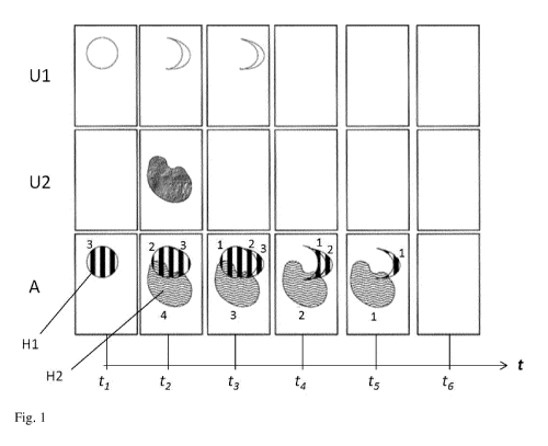
Fig. 1 shows different representations of a field at various points in time ti
to t6. The
representations of the field are depicted as a rectangle. The top row labelled
with Ul is a weed
distribution map for the weed Ul. The middle row labelled with U2 is a weed
distribution map
for the weed U2. The bottom row labelled with A is an application map for two
different
herbicides H1 and H2.
Time is divided into six snapshots ti to t6. In this connection, time advances
column by column
from left to right.
Therefore, the first column depicts the field at a first point in time, the
second column depicts the
.. field at a later second point in time, and so on. The periods which lie
between two columns can,
for example, be the duration of a vegetation period (generally one year) of
the cultivated plant
which is cultivated on the field. The period can also be the vegetation period
of a weed/grass
weed. In general, the application of one or more herbicides has taken place in
the time period
lying between two successive columns ¨ this is depicted in the bottom row A ¨
unless no weeds
were detected over multiple time segments (last column).
In the top row, it is depicted where in the field at the points in time ti to
t6 the weed Ul has been
detected.
Fields Ul(ti), Ul(t2), U1(t3), U1(t4), Ul(t5) and U1(t6) therefore represent
weeds distribution
maps with regard to weed Ul. Analogously, fields U2(t/), U2(t2), U2(t3),
U2(t4), U2(t5) and
U2(t6) represent weeds distribution maps with regard to weed U2. The
distributions of weeds 1
and 2 could also have been pooled in a single distribution map, but they are
depicted here
separately.
17
-
CA 03029322 2018-12-27
At point in time ti, a weed Ul was identified in the field; weed Ul was
present in the form of a
circular region (= subarea) (see U1(0).
At the same point in time ti, there was no weed U2 in the field (see U2(0).
An application map A(0 was created from weeds distribution maps U1(0 and U2(0.
Since only
weed Ul was detected on the field, application map A(0 also contains only
information and
instructions with regard to weed Ul . In application map A(0, a circular
region is marked with
hatching, in which region weed Ul was detected in U1(0. In said region, it is
intended that
herbicide H1 be applied. The numeral 3 above the hatched region indicates that
this subarea is to
be treated a total of three times (N=3) with herbicide Hl.
At a later point in time after the application of herbicide H1, it can be seen
in U1(t2) that weed Ul
is clearly no longer to be detected in the prior circular region; the
application of herbicide H1 was
clearly successful. However, a crescent region next to the previous circular
region has evolved
instead, in which crescent region weed Ul was detected. Thus, weed Ul has
shifted right in the
field.
In addition, a weed U2 has appeared (see U2(t2)). These findings yield
application map A(t2).
First of all, A(t2) shows that herbicide H1 is to be further applied in the
circular region in which
weed Ul was detected in U1(0, even though it was no longer detected in U1(t2).
This is
precisely the core of the present invention: application map A(0 is
used/worked through multiple
times. The numeral 2 above the hatched region indicates that this subarea is
to be treated twice
more (N=3-1=2) with herbicide Hl.
Application map A(0 has been extended to A(t2) on the basis of the findings in
Ul(t2) and
U2(t2). Since a crescent region of weed Ul has now been detected in Ul(t2),
the hatched region
was extended accordingly in A(t2). The numeral 3 above the extended hatched
region indicates
that said extended region is to be treated a total of three times (N=3) with
herbicide Hl.
In addition, A(t2) indicates that herbicide H2 is to be applied in the region
(wavy region) in which
weed U2 was detected in U2(t2). The number 4 below the wavy region indicates
that this subarea
is to be treated a total of four times (N=4) with herbicide H2.
Ul(t3) shows that the region containing weed Ul has shifted further right. In
U2(t3), weed U2 has
completely disappeared. A(t3) represents the application map associated with
Ul(t3) and U2(t3).
In the circular region of A(0, herbicide H1 is also to be further applied as
per A(t3), specifically
once more (N=1). In the crescent region too which was added to the circular
region in A(t2),
herbicide H1 is to be further applied, specifically twice more (N=2). In
addition, herbicide H1 is
to be applied in the region which newly appeared in Ul(t3), specifically a
total of three times
(N=3).
18
CA 03029322 2018-12-27
As per A(t3), herbicide H2 is, too, to be applied once again, specifically in
the same region as in
A(t2). No new regions with weed U2 were added in U2(t3).
Ul(t4) shows that no more weed Ul was detected on the field after the
application as per A(t3).
U2(t4) shows that no more weed U2 was detected on the field after the
application as per A(t3).
Nevertheless, herbicides H1 and H2 are applied as per A(t4). In the circular
region from A(t/), no
more herbicide H1 is applied for the first time in A(t4) (N=0). In said
region, herbicide H1 was
applied three times ¨ this number of applications is sufficient for
permanently eliminating the
nest.
In the crescent regions which were added to the circular region in A(t2) and
A(t3), application is
to be carried out once again; once more (N=1) in the case of the crescent
region that appeared
first (see Ul(t2)), twice more (N=2) in the case of the crescent region that
appeared thereafter (see
Ul(t3)).
The region from U2(t2) is to be treated with herbicide H2 twice more (N=2) in
A(t4).
In Ul(t5) and U2(t5), no more weed was further detected. Nevertheless,
herbicide H1 and
herbicide H2 are further to be applied as per A(t5): a last time (Ni) in the
region of Ul(t3) with
herbicide H1 and a last (N=1) time in the region of U2(t2) with herbicide H2.
Ul(t6) and U2(t3) indicate that no more weed was further detected. As per
A(t6), an application of
a herbicide is not necessary.
It should be additionally noted that this example did not explicitly mention
the economic
thresholds of weed Ul and weed U2. In this example, it could be assumed, for
example, that
whenever weed Ul or weed U2 was detected in the field, the economic thresholds
had been
exceeded.
19