Note: Descriptions are shown in the official language in which they were submitted.
13062~9
C~UNICATICNS SYSTEM WIlff MOVING BODIES WIl}~ I~E A~) OF SATELLITES
. . _
DESCRIPTI~N
The present invention relates to a communications system with moving
bodies relayed by satellites. The Applicant has designated this
system by the acronym ~SYCoMORES~ abbreviation for communications
system with moving bodies relayed by satellites.
The term moving body is understood to mean cars, lorries, ships, air-
craft, trains and, by extension, any user equipped with portable
terminals which are temporarily stationary.
In the early years of the space era communication satellites appear~
with a period equal to 12 hours and with highly ell;rtical orbits
(perigee approximately 1,000 km and apogee 39,000 km). These systems
were mainly develqped by the USSR with M~LNYA-type satellites.
However, this suffers f m m the follcwing disadvantages~
by no means negligible atmospheric deceleration due to the limited
perigee height,
significant interference from the earth's potential, inversely
proportional to the value of the semi-major axis of the orbit,
double passage through the Van Allen regions,
needs to use at least three satellites for a 24 hour coverage,
elongated lenticular shape of the c w erage zone in accordance with
an east-west axis, not very suitable for Western Eurape,
significant variation in the satellite ~earth distance leading to a
high Doppler effect and a ~zoom~ effect causing radio coverage and
attitude control p m blems.
The event of geostationary satellites made it possible to solve
certain of these problems. Such satellites, with their eqyatorial
circular orbit and period of 24 hours, seen to be immobilized above
the earth, so that they can constitute privileged relays for tele-
oommunications networks.
However, this solution still suffers fron disadvantages. Thus, the
:
.
/, ~k
B 9606 E~;
., ~
~3~
-- 2 --
elevation angle of a geostationary satellite, seen from a moving bcdy
on the ground, varies with the latitude of the moving body, which
implies a pointing of the antennas towards the satellite. The
following taU e gives values for the elevation as a function of the
S latitude of a place, for a certain number of tcwns in the northern
hemisphere in an area between the Maghreb and Scandinavia.
LATrllJDEMAX. ELE~TION
KIRUN~ 68 162
S~XKHOIM 593 23
COPENHAGI~ 555 265
AMSTERDAM 523 30
PARIS 49 o 1 33 8
llJRIN 452 385
MADRID 40 6 44 6
ALGIERS 366 47O3
Although this elevation varies, it is relatively small for high
latitudes, whlch causes transmission problems. Thus, for an elevation
angle of e.g. 38, a 8 m high obstacle 10 m from a moving body would
prevent communication.
However, such obstacles are frequently encountered in cities and
suburbs.
Moreover, the azimuth of the moving body-satellite direction changes
continuously with respect to the mcving body, when the latter changes
its direction of move~ent. It is therefore necessary to provide means
for permanently pointing the antenna of the moving body towards the
satellite. Finally, with regards to the retransmission mean8 on board
the satellite, their power being proportional to l/sin E (in which E
- is the elevation), it varies with the latitude of the working area, or
at least it is fixed to a high value dictated by the lowest elevation.
,
In order to obviate these disadvantages, constellations of satellites
have been proposed with coordinated orbits such that a permanent
B 9606 RS
i3~62~9
.
coverage is ensured on the ground. For example, in the GPS/NAVSTAR
system, there are 21 satellites with circular orbits of period 12
hours, four such satellites always being in direct view from a point
on the earth. European patent application 213 355 describes a constel-
lation of this type, but with only four satellites having elliptical
orbits. These satellites have the same period and different tra oe s
on the ground. Two satellites have their perigee in the northe m
hemisphere and the two others in the southe m hemisphere. Therefore
any point on earth can ~see~ one of these satellites at all times.
However, such a system still suffers from disadvantages, in the sense
that the elevation of the satellite seen from the moving body varies
considerably between individual regions of the earth.
Other constellations are described in the article by J.E. DRAIM
entitled "Three- and four- satellite cantinucus-ocverage constellatio,ns~
published in ~Journal of Guidance, Control and Dynamics~, vol. 8,
No. 6, November/Decenber 1985, pp 725-730.
- Although of interest in certain respects, none of these constellations
; makes it possible to solve all the problems inherent in communications
; with mcving bodies, which are essentially as follows:
first it is highly desirable to get round the need from having to
orient the vehicle antenna towards the satellite:
it is preferable to be able to use high gain antennas (e.g. above
10 dB) in order to increase the transmission capacity;
finally, the system must be well protected against interference from
the environment.
The present invention therefore relates to a system obviating the
disadvantages of the prior art and which ~ ets all these requiremRnts.
To this end, the invention provides a system, which comprisess
at least one central station an the grcund at a place close to the
centre of a coverage area with a substantially triangular geographical
shape, said statian being connected to a communications network and
having an antenna orientable in the vicinity of the vertical,
,~
'
B 9606 RS
~306289
-- 4 --
at least two geosynchronous satellites having elliptical orbits with
identical characteristics and the same trace on the ground, but having
longitudes of ascending node displaced by 2 ~/n if n is the number of
satellites, each said satellites having transmission-reception means
connected to antennas and msans for pointing these antennas towards
the central station on the ground for the complete time during which
the satellite passes over the gr~und coverage area,
moving bodies equipped with a vertically pointed high gain antenna.
Compared with the MOLNYA-type 12 hour, elliptical orbit constellations,
the present invention leads to an absence of atmospheric deceleration,
no passage through Van Allen zones, reduction of the interference due
to the earth's potential, two satellites (and not three) are adequate
for a 24 hour coverage (even though three satellites make it possible
to obtain a certain redundancy), adaptation of the shape of the
coverage zone (spherical triangle) to Europe, absence of eclipses in
northern or southern latitudes a~ove 35 and a limited variatio,n in
the distance between the satellite and earth leading to a reduced
Doppler effect and to a configuration of the satellite very close to
that of a geostationary satellite.
The system according to the invention can operate with only two
satellites, whose longitudes of ascending nodes are displaced by 180.
This is the constellation with the minimum nu~ber of satellites for
24 hour coverage. However, a constellatio,n with three satellites,
whereof the longitudes of ascending nodes are displaced by 120 with
respect to one another, allows a 24 hour coverage, even in the case
of a breahdown of any one of the three satellites of the constellation.
In this way it is possible to ensure the perenniality of the service
for a given life of the system.
The invention is describsd in greater detail hereinafter relative to
non-limitative embcdiments and the attached drawings, wherein show:
Fig. 1 Diagrammatically the system according to the invention.
Fig. 2 The geographical coverage obtained and the ground trace
of the satellites.
B 9606 RS
- 13Q6289
-- 5 --
.
Fig. 3 In greater detail, the altitude of the satellites.
Fig. 4 The operation of a constellation with two satellites.
Fig. 5 The operation of a constellation with three satellites.
Fig. 6 An example of a satellite which can be used for realizing
the invention.
Fig. 7 A diagram for the launching and putting into orbit of
satellites.
I-n the following description, it will be assumed that the area covered
by the system is located in the northern hemisphere between approx-
imately latitudes 35 and 60 and approximately between longitudes -10
and +20. Such an area essent;ally covers North Africa, Weste m
Eurcpe and the south of the Scandinavian peninsula. It is obvious
that the invention is not limited to such an area, but can easily be
adapted to any other area of the world located in either of the two
hemispheres.
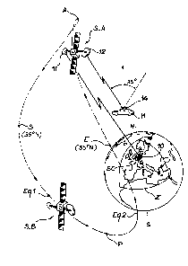
Fig, 1 ~hows a coverage area Z in the form of a spherical triangle,
a central station æ located on the ground at a point close to the
centre of the area and two geosynchronous satellites S-A and S-B
having elliptical orbits with identical parameters. In an exemplified
; 20 manner, these parameters can be apcgee A at approximately 50 543.4 hm,
perigee P at appraximately 21 02~.6 hm, semi-najor axis 42 164 hm,
inclination of 634, argument of the perigee 270 and eccentricity of
~; the orbit 0.35.
'
on the orbit of fig. 1 are marked the points Eql and Eq2 located in
the plane of the equator, as well as points E and S at latitude 35
and respectively corresponding to the entry into and the exit from
the ~perational zone of the satellites.
Each satellite has one or two antennas 11 and 12, each of which is
pointed towards the central station SC throughout the period when the
satellite is passing over the coverage area. The central station can
, comprise a connection station and a control station.
B 9606 RS
. .
.
3 3(~6Z89
-- 6 --
Fig. 1 also shows a moving body M (which is obviously located in the
area Z, but which is shown above the same for reasons of clarity).
Each moving body is equipped with an antenna 14, whose axis points
permanently towards the zenith (it is consequently not orientable).
As will be shown hereinafter, the maxi~um angle between said vertical
axis and the moving body-satellite line is 35.
Three phases can be distinguished for describing the operation of
this system:
first phase: beyond latitude 35 north, the satellite retransmitter
is in service, communications to the moving bodies are relayed by the
satellite, via the ground connection station and for a given satellite
this phase lasts 12 hours;
second phase: between 35 and the equator there is an ascending part
(from south to north) and a descending part (from north to south),
whereby during the fonmer the contral station verifies the state of
the satellite and controls its putting into operation just prior to
latitudé 35, wherea9 during the latter the contr~l station controls
~ the putting out of operation of the transmitters on board the satel-
lite and checks the state of the satellite before it becomes invisible
for the station and this second phase lasts 6 hours;
third phase: the satellite is beneath the plane of the equator, so
that it is left to its own devices, naturally unless a supplementary
control station is located somewhere in the southem hemisphere and
this last phase lasts 6 hours.
Fig. 2 shows the ground tra oe of the satellites. It shauld be
stressed that this trace is the same for two or three satellites.
This trace 20 enters area Z at point E, loops towards latitude 60
north and passes out of the area at point S. Points E and S are at a
latitude of approKimately 35.
Within the triangular geographical area Z, whatever the location where
the moving bcdy is located, it is possible to see fran said locaticn
at least one satellite during 12 c~nsecutive hours. Moreover, in area
Z, the elevation of the satellite seen frcn a moving body is a~ways
B 9606 RS
13~62~
, .
-- 7 --
between 55 and 90. Therefore the satellite is always seen within a
vertically axed ccne, whose cone semi-angle is less than 35.
Fig. 2 also shows an area Z' which is slightly more extensive than
area Z. In said area, the satellite visibility angle is between 50
and 90.
Fig. 3 shows the altitude of the satellite with respect to the ground.
On the two axes of the horizontal plane are plotted the longitude and
latitude and on the vertical axis the altitude. Only the part located
above latitude 35 north is used. This graph makes it possible to
evaluate the small altitude variation of the satellites with the
advantages devolving therefrom and which were stressed hereinbefore
(quasi-geostationary position).
Figs. 4 and 5 illustrate the use of the system in two types of
constelLation (with two or three satellites).
Fig. 4 shows the constellation with only two satellites S-A and S-B,
which have longitudes of ascending node displaced by 180~. Fron hour
zero, considered as the origin and marked Oh and which corresponds to
~- the entry of satellite S-A above the coverage area, to 12 h, corres-
ponding to the leaving of said zone, any point in the zone is visible
frcm satellite S-A, so that corrunications are relayed by S-A. Fron
12 to 24 hours, satellite S-B is in direct visibility and comnuni-
cations are relayed by S-B. In this configuration, the latitude sweep
`-~ of the orientable antenna integral with the satellite is -15- and the
longitude sweep +2-.
~; 25 In fig. S the constellation has three satellites S-A, S-B and S-C,
which have ascending node longitudes displaced by 120.
In normal operation, there is a certain redundancy in the choioe of
the relay satellite. Fron 0 to 12 h, the relay can be satellite S-A,
fron 8 to 20 h satellite S-B and fron 16 to 24 h satellite S-C. In
, ,
B 9606 RS
~....
.
'''': :'' '
13Q6Z~9
-- 8 --
this ncminal configuration, the latitude sweep of the antennas is
still -15 and the longitude sweep -2.
If one of the three satellites develcps a fault, it is still possible
to obtain a 24 hour continuous service, by slightly modifying the
latitude sweep, which passes to -25, whilst the longitude sweep
passes to -35. For exa~ple, in the case of a failure of satellite
S-B, working will take place with satellite S-A frcm 0 to 12 h in the
nonmal mode and then fron 12 h to 12~2=14 h in the deteriorated mode
(with higher longitude and latitude) and then fron 16-2=14 h to 16 h
with satellite S-C in the deteriorated mode and 16 to 24 h with
satellite S-C in the nonmal mode. Thus, the duration of the
deteriorated operating period does not exceed 4 out of 24 hours.
Fig. 6 shows one of the satellite types which can be used for the
realization of the system according to the invention. It is a MATRA
EUROSTAR satellite. This satellite is stabilized in triaxial manner
and is equipped with a kinetic wheel maintaining an axis in the north-
south orientation. StellAr sensors are used for seeking and maintain-
ing this orientation.
As shown, the satellite coTprises a body 30, to which are fixed two
solar panels 31, 32 and antennas, particularly two parabolic antennas
34, 36. By kinetic moment transfer between the kinetic wheel and the
satellite body, it is possible to obtain a longitude sweep of a few
degrees of the pointing direction of the antennas.
The latitude sweep is obtained as a result of a degree of freedom
given to the antenna support (e.g. th mugh an orientable arm,
respectively 38-40). It is thus possible to obtain the requisite
sweep of appraximately +15. The combination of these two sweeps
enables the antennas to be constantly pointed onto the contr~l station
located in the centre of the coverage area.
.
Other satellites ca~ be used, e.g. the SPACEBUS 100 B satellite of
B 9606 RS
.
13~6289
g
AEROSPATIALE with an antenna orientation mechanism of the type lM.P.A.
AEROSPATIALE~.
Numerous strategies are possible with regar~ds to the putting into
orbit of the satellites. Only one of these will be described in an
explanatory manner in conjunction with fig. 7. It makes use of the
ARIANE rv rocket and requires three boosts. During launching, the
satellite is accompanied by an ordinary geostationary satellite. The
two satellites are placed on the standard transfer orbit of the
ARIANE rv rocket, namely an orbit located in an quasi-equatorial plane
(inclination of 7), with a perigee of 200 km, an apogee of 35 975 hm
and a perigee argument of 178 (orbit marked OST in fig. 7).
In the vicinity of the perigee of this standar~ transfer orbit, one
satellite rocket is ignited for a first boost able to raise the
apogee to 98 800 km, the orbit remaining in the same plane (orbit 01).
This boost can be broken down into two or three boosts.
In the vicinity of the apogee of orbit 01, a new boost is given to
change the plane of the orbit. The inclination of the latter is close
to that of the final orbit (namely 634). This constitutes the
greatest th¢ust and this can be broken down into two or three indi-
vidual thrusts, the orbit becoming 02.
,,
Finally, at an appropriate point of this orbit, a third thrust is
imparted to the satellite to give it its final orbit.
;~ With regands to the communications means between the ground station,
the satellites and the moving bodies, it is possible to use any means
known in the field of space telecommunications.
However, in an explanatory manner, it is pointed out thats
the link between the connection station and the satellite can take
place in band C between 6425 and 6525 MHz in the ground-satellite
direction and between 3600 and 3700 MHz in the satellite-ground
direction,
B 9606 RS
~^ ,
.
' ' :
1306289
-- 10 --
the link between the control station and the satellite can take place
in band S between 2029 and 2033.6 MHz in the ground-satellite
direction and between 2203.5 and 2208 MHz in the satellite-ground
direction,
the link between the satel~ite and the various moving bodies (or
possibly fixe~ stations) can take place in band L between 1646.5 and
1660.5 MHz in the grcund-satellite direction and between 1545 and 1559
MHz in the satellite-ground direction.
The ground control station can operate with a 1000 W transmitter in
band S and with a diameter 6 m,gain 41 dB antenna. The connecticn
station can operate with a lO W transmitter in band C and with a 2.5 m
diameter, 42 dB gain antenna.
On board each satellite, there are three retransnitters, respectively
S W in band S, 400 W in band L and 10 W in band C. The band C antenna
will have a gain of 30 dB and a diameter of 2.5 m and the band C
antenna a gain of 32 dB and a diameter of 0.75 m.
Naturall~, these values are only given in an exe~plified manner and
in no way limit the scope of the invention.
B 9606 RS