Note: Descriptions are shown in the official language in which they were submitted.
1~2~7~
BACKGROUND OF THE INVENTION
This invention relates generally to surveying o~
boreholes, and more particuIarly concerns methods and
apparatus which enable significant reductions in well
survey time; also it relates to land navigation apparatus
and methods.
In the past, the task of position mapping a well
or borehole for azimuth in addition to tilt has been
excessively complicated, very expensive, and often
inaccurate because of th~ difficulty in accommodating the
size and special requirements of the available
instrumentation. For example, magnetic compass devices
j typically require that the drill tubing be fitted with a
few tubular sections of non-magnetic material, either
initially or when drill bits are changed. The magnetic
compass device is insarted within this non-magnetic section
and the entire drill stem run }nto the hole as measurements
are made. These non-magnetic sections are much more
expensive than standard steel drill stem, and their
availability at the drill site must be pre-planned. The
devices are very inaccurate where drilling goes through
magnetic materials, and are unusable wher~ casing has been
installed.
Directional or free gyroscopes are deployed much
as the magnetic compass devices and fun¢tion by attempting
to remember a pre-set direction in space as they are run in
the hole. Their ability to initially align is limitad and
di~icult, and their capability to remember degrades with
tim~ and environmental expo~ure. Also, their accuracy is
reduced as instrument size is reduced, as for exa~ple
becomes necessary for small well bores. Further, the range
,i, ,~.
,
r. ` : ~ : , .
~,. .
,. . .
;`~
:l `
132~47
~, of tilt and azimuthal variations over which they can be
' used is restricted by gimbal freedom which must be limited
to prevent gimbal lock and consequent gyro tumbling
A ma}or advance toward overcoming these problems
is described in my U.S. Patent No. 3,753,296. That
invention provides a method and means for overcoming the
: above complications, problems, and limitations by employing
j that kind and principal of a gyroscope known as a rate-of-
turn gyroscope, or commonly `a rate gyro', to r~motely
determine a plane containing the earth's spin axis
(azimuth~ while inserted in a bore-hole or w~ll. The rate
~ gyroscope has a rotor defining a spin axis; and means to
:1 support the gyroscope for traval in a bore-hole and to
rotate about an axis extending in the direction of the
hole, the gyroscope characterized as producing an output
. which varies as a function o~ azimuth orientation of the
.'J, gyroscope relative to the earth's spin axis. Such means
typically includes a carrier containing the gyroscope and
motor, the carrier being sized for travel in the well, as
for example within the drill tubing. Also, circuitry is
operatively connected with the motor and carrier to produce
~! an output signal indicating azimuthal orientation of the
^, rotating gyroscope relative to the carrier, whereby that
~ signal and the gxxoscope output may be processed to
.~ 25 determine azimuth orientation of the carrier and any other
.l instrument thereon relative to the earth's spin axis, such
¦ instrument for example comprising a well logging device
such as a radiometer, inclinometer,etc.
U.S. Patent 4,192,977 improveR upon 3,753,296 in
that it provides for use of ~ "rate ~yrol' in co~bination
:~ with a free gyroscope, with the rate gyro used to
. periodically calibrate the free gyroscope. ~hile this
: . combination has certain benefits, it does not provide the
; unu~ually advantageous modes of op2ration and re~ults ~s
~ - 2 -
,,
d
~32~7~
are afforded by the present invention. ~mong these are the
enablement of very rapid surveying of boreholes; the lack
of need for a free gyroscope to be periodically calibrated;
and reduction in time required for surveying slanted
boreholes, of particular advantage at depth~ where high
temperatures are encountered.
The improvements in high 6speed well surveying
discussed herein also find applicat:ion in methods and
apparatus for land-vehicle navigation. In present land
vehicles, self-contained navigation capabilities have been
provided by l).use of various magnetic-compass direction
references and a suitable sensor for measuring distance
traveled over the earth, or 2) use of various ~ree-
gyroscope direction references and a suitable sensor for
distance traveled over ~he earth, or 3) use o~ complete
inertial navigation systems, with or without ~xternal
position or velocity reference aids. These approaches have
generally been of relatively poor accuracy for reasonable
costs, or of excessive cost for highly accurate syste~s.
In many land vehicles the large mass of iron-based
materials completely prevents the use of magnetic-compa~s
type direction sensors for all but the poorest performance
requirements.
The land-vehicle navigation problem can be seen
to have considerable similari~y to ~he high speed well
surveying problem. A sensor that provides a measure of
vehicle distance traveled over the earth can be seen to
provide the same type of information as that provided by
the borehole-surveying apparatus wireline that measures the
progression distance of the survey tool along the borehole
axis. If the land vehicle carries an apparatus to measure
inclination and azimuth directions for the vehicle, which
apparatus is substantially equivalent to the basic
apparatus describe herein for well surveying, then vehicle
- 3 - :
., ~ ~
.. .. .
.
;" ' ' , '
': '
~32~7~
positioning with respect to the qtarting point as it
trav~ls over the earth surface can be computed. This
computation is very similar to that for computing the
position o~ the borehole survey apparatus as it progresses
through the earth along the borehole.
In the borehole survey problem the survey tool is
confined laterally in the borehole by the borehole
dimensions and is generally traveled along khe borehole
direction at a constant velocity, Th~se constraints reduce
tool accelerations to negligible values so that no
significant errors are introduced in computing azimuth,
inclination or tilt, and position of the tool along the
borehole. ~lso, the borehole survey problem normally
applies to paths ra~ging from vertical to near horizontal.
The land vehic~e navigation problem is concerned
with substantial horizontal accelerations during vehicle
travel over the earth, both in the along path and cross-
path directions. Also, the vehicle path is nominally in a
horizontal plane with e~ually-expacted up and down movement
over typical hilly terrain.
This continuation-in-part application addresses
the application of unusually advantageou~ methods and
apparatus developed for high speed well survey to the land
vehicle navigation problem, and describes modifications and
extensions that permit highly accurate navigation in the
presence of the dynamic acceleration environment of the
land vehicle traveling over the surface oP the earth,
i
~ su~aRy OF THE INVENTION
~ .
`1, It is one major object of the inv~ntion to
provide method and apparatus facilitating rapid surveying
of boreholes, as referred to. Typically, the survey method
employs first means ~or measuring angular rate, and second
-- d, --
;` :
.
` .: . ~, . ' , ~, ' , .
,,~ ' .
'' '.' ', ' " ~ '' ''', . ;.
:,'.' ~ . '~ ':
,' ;' ~ , ' . ' ' ' '
: ~32~47~
means for sensing tilt, said mean~ having sensitive axes,
a rotary drive for the first and second mean~, and
~, circuitry to process outputs of the P~ensor~ and to control
the drive the basic steps of the method including:
a~ operating the drive and the first and second
mean~ at a first locati~n in the borehole, and
also operating said circuitry to produce signal~
. used to determine the azimuthal direction of
J tilt of th~ borehole at such location,
b) then traveling the first and second mean~ and
~, the drive lengthwi~e of the borehole away from
j the location, and operating the drive and at
.~ least one of the first and second means during
such trave~ing and also operating said
circuitry~ to produce signals used to determine
~`~, changes in borehole alignment during traveling,
, c) and maintaining at least one o~ said sensitive
3 axes at a predetermined orientation relative to
horizontal during said travel.
l 20 As will be seen, the c) step o~ the method
~ typically i~volves maintaining an input axis defined by the
3 second means at a predetermined orientation (such as
`~, horizontal) during traveling/ the drive being controlled to
accomplish thiso For example, the first mean~imay i~3clude
q~ 25 first and second gyroscopes input axes, one being
il maintained horizontal during such travel. Accordingly, if
the borehole changes its direction of tilt during
instrumentation travel, the one gyroscope input axis sen~ies
~3 changes in azimuth during the travel be.tween upper and
!,~ 30 lower positions in the ~ell. Further, the a) step of the
,~ method may be carried out at each o~ the upper and lower
po~itions prior to and subsequent to such travel, ~or
accurately determining azimuthal direction o~ tilt of the
~i hole at such locations. The a) and b) steps may be carried
~i .
~ 5 - .
~` 7
.~ ~
,'".','' ~ ' , : ' : : ;, , ~ ` : , ' `:
.~'i . : ' ~ ' ' '
;~ `
.~ ~
~32~7~
1 ,
out in alternation, up or down the hole, to enable rapid
sur~eying, as will be seen. One or more rate gyroscopes
having one or more input axes can be used.
) Apparatus embodying the invention comprises:
'7 5 a~ angular rate sensor means having at lea~t one
sensitive axis,
b~ tilt sensor mean~,
~. c) a rotary drive operatively connected to said a)s and b) sensor means to rotalte same about an axis¦ 10 extending generally in the direction of the
:l borehole,
I d) and circuitry operatively connected with said a)
;i and b) sensor means to determine the azimuthal
direction of tilt of the borehole at a first
location therein, said a) sensor means also
connected in feedback relation with the drive
whereby the sensitive axis of the a~ sensor
~ means is maintained at a prçdetermined
'71 orientation relative to said first location, and
i~ 20 whereby changes in borehole aliynment during
,Z said travel may be determine~.
The methods and apparatus of the land-vehicle
. navigation system disclosed herein correspond to those
described above for finding inclination and azimuth of the
~' 25 survey tool in th~ borehole. The principal diff2rences are
that the methods and apparatus are used in a land vehicle
rather than in a borehole and that for improved accuracy in
;~ some uses, a sensor for providing a measu~e of the vehicl~
veloci~y or distance o~ travel is added. With such a
3Q sensor, dynamic corrections to the vehiale vertical-
direction indications can be computed. The sensor output
may also be used to compute vehicle position relative to
the initial starting point by combining the vehicle travel
1` measurement properly with the azimuth and inclination (or
:7 - 6
.
,~"; :
.. . .
2 ~ 4 7 ~
' .
tilt) outputs of the inertial angular rate and inclination
sensing means.
Basically, the land navi.gation apparatus in
accordance with the invent.ion comprises, in combination
with a land vehicle:
` a) inertial angular rate ~ensor means having at
-~ least one sensitive axis,
b) inertial acceleration tilt sensor means having
at least two sen itive axes, and sensitive axes
; 10 being arranged to be nominally located at the
; vehicle in a plane para:Llel to the Earth's
surface,
c) a rotary drive operatively connected to said
a) means to rotate said a) means about an axis
~ 15 extending generally at the vehicle in a plane
!~ parallel to the Earth's sur~ace,
I d) circuitry operatively connected with said a) and.:t b) sensor means to determine three vehicle
orientation angles, roll, pitch, and azimuth,
with respect to an Earth-fixed coordinate set at
~'~ a first location, and to also determine said
~, three vehicle orientation angles as the land
vehicle travels over the Earth surface wherein
~ changes to said azimuth angle during trav~l are
i~ 25 determined by integration of the output o~ said
i, a) sensor means,
"! e) said a) and b) ~eans and said c) drive being
carried by the vehicle.
.~ These and oth~r objects:and ~dvantaqes of the
1',:
' 30 invention, as well as th~ details of illustrative
:; embodiment, will be more fully understood fro~ the
~ following description and dirawing , in which:
,
:~
. , .
., , ; .
:,
:, :
...
.....
;
t32a~7~
; DRAWING DESCRIPTION
Fig. 1 is an elevation taken in section to show
~' one form of instrumentation employing the invention;
Fig. la is a aircuit diagram:
Fig. 2 is an elevation showing use of the Fig. 1
`- instrumentation in multiple modes, in a borehole;
'~ Fig. 3 is a schematic lelevation showing a
modification of Fig. 1 instrumentation;
~A Fig. 4 is a fragmentary elevation showing
d 10 variable cant mechanism a~ usable in the Fig. I
`? inistrumentation;
-~`, Fig. 5 is a ide view taken on lines 5-5 of
, Fig. 4;
Fig. 6 is a vertical section showing further
details of the Fig. 1 ap~aratus as used in a borehole;
Fig. 7 is a diagram indicating tilt of the
apparatus in a slanted borehole;
1, Fig. 8 is a wave form diagram;
'~ Fig. 9 is a block diagram showing modified
apparatus;
Figs. lO and 11 show modifications;
~igs. lb and lc are modification associated
circuit diagrams; ~ :
1 Fig. 12 is an elevation showing one confi~uration
s 25 of a land-vehicle navigation mechanization employing the
i invention;
~5 Fig. 13 is a diagram showing the simplescst
`/. possible configuration of a land-vehicle navigation
mechanization based on the invention;
Fig. 14 is a diagram of modi~ications to improve
accuracy in a dynamic environment;
. Fig. 15 is a diagram o~ additional modifications
~ to provide self-initialization of the azimuth direction of
`!' the vehicle;
:i
l - 8 -
.,
.i
i33. c~
';
"
.. . . . ..
, ' , ' ~ ` ~ : .
11 32~7~
~, Fig. 15a shows an alternative fo~m, for such
self-initialization;
! Fig. 15k shows a block diagram for controls
related to Fig. 15a; and
Fig. 16 is an improvement over Fig. 15 ~or
certain initial vehicle orientations during such self-
initialization.
DETAILED DESCRIPTION
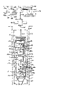
Referring to Fig. 1, a carrier such as
elongated housing 10 is movable in a borehole indicated
at 11, the hole being cased at lla. Means such as a
cable to travel the carrier lengthwise in the hole is
indicated at 12. A motor or other manipulatory drive
means 13 is carried by and within the carrier, and its
rotary output shaft 14 is shown as connected at 15 to
angular rate sensor means 16. The shaft may be extended
at 14a, 14b and 14c for connection to first acceleration
sensor means 17, second acceleration sensor means 18, and
. a resolver 19. The accelerometers 17 and 18 can together
be considered as means for sensing tilt. These devices
hav~ terminals 16~ 19a connected via suitable slip
, rings with circuitry indicated at 29 carried within the
'A carrier (or at the well sur~ace, if desired)~
Circuitry 29 typically may include a feed back
axrangement as shown in Fig. la, and incorporating a feed
back amplifier 21, a switch 22 having arm 22~ and
~ contracts 22b and 22c, and switch actuator 23aO When the
;~ actuator clo~es arm 223 with contract 22c, the resolver - -
19 is connected in feed bacX relation with the drive
motor 13 via laads 24, 25~ and 26, and amplifier 21, and
the apparatus operates for example as described in U.S.
Patent 3,753,296 to determine the azimuthal direction oP
tilt o~ the bore hole at a ~ir~t locatis~ in the bore
J, _ 9 _
r~
.
''"'; ~ .. ~' .: ' ,, ~ '
132~47~
hole. See for example first location indicated at 27 in
Fig. 2. Othar U.S. Patents describing such operation are
4,1g9,869, 4,192,077, ~ 4,197,654. During such
operation, the motor 13 rotates the sensor 16 and the
s accelerameters either continuously "~r incrementally.
:~ The angular rate sen~or 16 may for example take
the form of one or more of the ~ollowing known devices,
but is not limited to them:
1. Single degree of freedom rate gyroscope
2. Tuned rotox rate gyroscope
3. Two axis rate gyroscope
4. Nuclear spin rate gyroscope
.~ 5. Sonic rate gyroscope
6. Vibrating rate gyroscope
7. Jet stream rate gyroscope
8. Rotating angular accelerometer
9. Integrating angular accelerometer
10. Differential position gyroscopes and platforms
11. Laser gyroscope
12. Fibre optic rate gyroscope
13. Combination rate gyroscope and linear
accelerometer
"I Each such device may be characterized as having
i a "sensitive" axis, which is the axis about which
i 25 rotation occurs to produce an output which is a measure
~; of rate-of-turn, or angular rate ~. That value may have
~: components ~ 2 and ~3, in a three axis coordinate
system. The sensitive axis may be generally normal to
the axis 20 of instrument travel in the borehole, or it
~ 30 may be canted at so~e angle ~ relative to axis 20 (see
`~ canted sensitive axis 16b in Fig. 1).
The acceleration sensor means 17 may for
example, take the form of one or more of the following
....
'" ' -- 10
., .
;. - ' ~ : .
132~7~
known devices; however, the term "acceleration sensor
means'l is not limited to such devices:
1. one or more single axis accelerometers
2. one or more dual axis accelerometers
3. one or more triple axis accelerometers.
Examples of acceleration sensors include the
accelerometers disclosed in U.S. Patents 3,753,296 and
4,199,869, having the functions disclosed therein. Such
sensors may be supported to be orthogonal or canted at
some angle ~ relative to the carrier axis. Tbey may be
stationary or carouseled, or may be otherwise
manipulated, to enhance accuracy and/or gain and added
axis or axes of sensitivity. The sensor 17 typically has
two output axes of sensitivity. A canted axis of
sensitivity is seen at 17b in Fig. 1, and a canted
accelerometer 17' (corresponding to accelerometer 17 in
Fig. 1) is seen in Fig. 3. The axis of sens.itivity is
the axis along which acceleration measurement occurs.
The second accelerometer 18 may be like
accelerometer 17, excepting that its input axis 23 is
typically orthogonal to the input axes of the sensor 16
and of the accelerometer 17. During travel mode, i.e.
lifting or loweriny of the carrier 10 in the borehole 11,
: indicated at 27' in Fig. 2, the output of the second
accelerometer 18 i connected via lead 30 (in Fig. la),
contact 22k, switch arm 22a, and servo ampli~ier 21 to
the drive mctor I3. The servo system causes the motor to
rotate the shaft 14 until the input axis 23 of
accelerometer is horizontal (assuming that the borehole
has tilt as in ~ig. 2). Typically, there are two such
axis 23 horizontal positions/ but logic circuitry in the
servo-system may for example cause rotation until the
output of acceleration sensor 18 is positive. Amplifier
;; 21 typically includes signal conditioning circuits 213,
-- 11 --
..~
.. . . . . .
': ~. .:
r ~ :
132 ~7 i3
feedback compensation circuits 21b, and power amplifier
, 21c driving the motor M shown at 13.
If, for example, the borehole is tilted 45~ due
;. East at the equator, accelerometer 17 would register +
~ 5 .707 g or 45, and the angular rate sensor 16 would
i register no input resulting from the earth's rate of
-. rotation. If then, the apparatus is raised (or lowered)
in the borehole, while input axis 23 of accelerometer 18
is maintained horizontal, the output from accelerometer
17 would remain constant, assuming the tilt of the
borehole remains the same. If however, the hole tilt
changes direction ~or its elevation axis changes
' direction) the accelerometer 17 senses such change, the
: amount of such change being recorded at circuitry 29, or
at the surface. If the hole changes; its azimuth
direction during such instrument travel, the sensor 16
senses the change, and the 3ensor output can be
integrated as shown by integrator circuit 31 in Fig. la
(which may be incorporated in circuitry 29, or at the
surface) to register the angle of azimuth change. The
instrumentation can be traveled at high speed along the
titled borehole while recording such changes in tilt and
i azimuth, to a second position (see position 27" in Fig.
2). At that position, the instrumentation is again
operated as at 27 (mode #1) to accurately deter~ine
borehole tilt and azimuth---essentially a re-calibration
step. Thus, the apparatus can be traveled hundreds or
d thousands of feet, operating in mode #2 as described, and
between calibration positions at which travel is arrested
. 30 and the device is operated in mode #l.
s The above modes of operation are typically
useful in the tilted portion borehole: however, normally
the main i . e . lower portion of the oil or gas well is
tilted to s~me extent, and requires surveying. Further,
- 12 - :
,
. 1 ~
" ~
, " ': ' ,
:' - ' ~, . .
132~7~
this part of the hole is typically at relatively high
, temperature where it is desirable that the
`~ instrumentation be moved quickly to reduce exposure to
j heat, the invention lending itsel~ to these objeotives.
1 5 In the vertic~l or near vertical ~usually upper) portion
-~ of the hole, the instrumentation can revert to mode #1
operation, at selected positions, as for example at 100
or 200 foot intervals. In a near vertical hole, azimuth
contributes very little to hole position computation, so
that mode #1 positions can be spaced relatively ~ar
apart, and thus this portion of the hole can be mapped
rapidly, as well.
j Figs. 4 and 5 illustrate technique for
-~ adjusting the angularity of the axis of sensitivity of - -
the fixst accelerometer relative to the lengthwise
direction of instrument travel in the borehole. As
shown, the accelerometer 317 (corresponding to
accelerometer 17) has an axis of sensitivity (input axis)
shown at 317b, which is rotatable about an axis 350 which
is substantially normal to the direction of travel 351 in
1 the borehole. Shaft extensions 314a and 314b correspond
;~ to extensions 14a and 14b in Fig. lo The accelerometer
j 317 is carried by pivots 352 in a frame 353 to which
1 shaft extension~ 314a and 314k are connected, as shown.
Control means 354 is also carried by the frame to adjust
the cant of axis 317b, as for example at locations of
~i mode #l opexation as described above, to improve the
determination o~ azimuthal direction of tilt of the
borehole, at such "calibration" locatîons, and/or at
other instrument locations in the hole~ The control
means 354 may, for example, comprise a jack screw 355
driven by a reversible motor 356 su~pended at 356a by the
frame. ~he jack screw extends laterally and interfits a
nut 357 attached to the accelerometer case, as for
- 13 -
,,
~,,
i
, , .. ~
,). . ,
: . ,
ii : .
~32~7~
..
example at its top, offset from axis 350. A servo system
356k for the drive may be employed, so that a chosen
angularity o~ axis 317b relative to direction 351 may be
aohieved. Support or ~uspension 356a may be resiliently
yieldable to allow the accelerometer to be adjustably
tilted, without jamming of the drive or screw.
Figs. 6-8 show in more detail the apparatus of
Fig. 1, and associated surface apparatus. In Fig. 6,
well tubing 110 extends downwardly in a well III, which
may or may not be cased. Extending within the tubing is
~ a well mapping instrument or apparatus 112 ~or
j determining the direction o~ tilt, ~rom vertical, of the
j well or borehole. Such apparatus may readily be traveled
i up and down in the well, as by lifting and lowering of a
cable 113 attached to the top 114 of the instrument. The
upper end o~ the cable is turned at 115 and spooled at
116, where a suitable meter 117 may record the length o~
cable extending downwardly in the well, for logging
purposes.
,! 20 The appar tus 112 is shown to include a? generally vertically elongated tubular housing or carrier
118 of diameter less than that of the tubing bore, so
~, that well fluid in the tubing may readily pass,
`, relatively, the instrument as it is lowered in the
~, 25 tubing. Also, the lo~er terminal of the housing may be
~; tapered at ll9, for assisting downward travel or
` penetration of the instrument through well liquid in the
'i tubing. The carrier 118 supports first and second~, angular sensors such as rate gyroscopes G1 and G2, and
accelerometers 120 and 121, and drive means 122 to rotate
~, the latter, for tra~el length~ise in the well. Bowed
~; spring~ 170 on the carrier center it in the tubing 110.
The drive means 122 may include an electric
motor and speed reducer functioning to rotate a shaft 123
;,
, - 14 -
;,
,~
.~
"~
,,
,
;"
.
: . ,, ~ ., : .
~32~7~
~ relatively slowly about a common axis 124 which is
:~, generally parallel to the length axis of the tubularcarrier, i.e. axis 124 is vertical when the instrument is
:. vertical, and axis 124 is tilted at the same angle from
vertical as is the instrument when the latter bears
`, sidewardly against the bore of the tubing 110 when such
' tubing assumes the same tilt angle due to borehole tilt
:i from vertical. Merely as illustrative, ~or the
continuous rotation case, the rate o~ rotation of shaft
lo 124 may be within the range O5 RP~ to 5 RPM. The motor
1 and housing may be considered as within the scope of. means to support and rotate the gyroscope and
accelerometers~
Due to rotation of the sha~t 123, lower
, 15 extensions 123a, 123b and 123c thereof, the frames 125
j and 225 of the gyroscopes and the frames 126 and 226 of
:, the accelerometers are typically all rotated
simultaneously about axis 124, within and relative to the
sealed housing 118. The signal outputs of the gyroscope3
~, 20 and accelerometers are transmitted via terminals at
suitable slip ring structures 125a, 225a, 12Sa and 226a,
and via cablea 127 127a, 128 and 128a, to the processing
~ circuitry at 129 within the instrument, such circuitry
`~ for example including that described above, and
multiplexing means if desired. The multiplexed or
: non-multiplexed output from such circuitry is transmittedvia a lead in cable 113 to a sur~ace recorder, as ~or
example include pens 131-134 of a strip chart recorder
~', 135, whose advancement may be synchronized with the
lowering of the instrument in the well. The driver
131a-134a ~or recorder pens 131-134 are calibrated to
' indicate borehole azimuth, degree of tilt and depth,i, respectively, and another strip chart indicating borehole
~ depth along its length may be employed, if desired. The
;1 - 15 -
:,,
,1
''~
.
... .
~;
~ , :
'~'', ` : ' ` ` ~' '
132~7i~
recorder can be located at the instrument for subsequent
retrieval and read-out after the instrument is pulled
from the hole.
The angular rate se~sor 16 may take the form o~
gyroscope G1 or Gz or their combination, as described in
i U.S Patent 4,199,869. Accelerometer~3 126 and 226
~ correspond to 17 and 18 in Fig. 1.
f, In Fig. 9 the elements 13, 16, 17 and 19 are
tha same as in Fig. 1, however, the second accelerometer
18 of Fig. l is replaced by a second angular rate sensor
190 (such as gyroscope G2) having ~ne of its axes of
sensitivity along the borehole axis, which serves the
same ~unction as the second accelerometer 18, Thus, the
angular rate sensor 190 maintains a gimbal axis fixed (as
~or example horizontal or at any other desired
~, orientation) during instrumentation travel in mode #2,
and its output i~ connected via the servo loop 22b, 22a
.~ and amplifier 21 to the drive ~otor 13, so that if the
-~ hole changes direction in tilt, during sllch travel
accelerometer 17 will sen~e the amount of change, for
recordation. The output of gyroscope 190 may
equivalently be provided by the second axis of a two
input axis first gyroscope, the other input axis of which
is also provided by the ~irst gyroscope. The second
accelerometer, 18, of Figure 1 could be added to the
., configuration of Figure 9 if a second orthogonal signal
', normal to the borehole axis is desired, and is shown for
i.~ that purpose as having output A2 in Figure 10.
, Figure 11 show~ an alternative approach to that
~' 3 0 of Figure 9 that has unique advantages in certain
applications. The second gyroscope G2 may alternative}y
,: be mounted directly on the carrier (10 in Fig~re 11), as
indicated at l90a and may have its output ~proportional
to angular rate sensed about the borehole axis)
~; - 16 -
,~
~ , .: , ~
132~76
integrated by integrator 31c (Figure lc) to provide a
measurement of the rotation of the carrier, 10, about the
borehole axis. This output measurement at K may then be
.
,~ combined, at 196 with the output signal Rl from the
resolver, 19, carried by line, 24, (:Figure lc) to
determine angle o~ shaft 14 with respect to inertial
` space. Thus, gyroscope G2 is further characterized as
., having an axis of input rate sensitivity along the
borehole direction and an output signal which is
integrated to determine changes in the orientation
of said carrier frame about an axis along the borehole
direction.
Either angular rate sensor G1 or Gz of Figure 9
3 may have a second axis of input rate sensitivity ~ -
nominally orthogonal to the borehole axis, 124, and the
~, first input axis of angular rate sensor 16. In this case
.j as represented in Figure lb, two angular rate signal
outputs as at 180 and 181 and two tilt sensitive signal
outputs (as at 17a' and 18a') from those axes nominally
orthogonal to the borehole axis may be combined and used
together as at circuitry 18~ to determine changes in thQ
borehole inclination and azimuth while traveling, without
~, requiring the use of the rotary drive mechanism to adjust
-~ any input axis to a horizontal or other known position.
The drive mechanism may then be left disconnected as by
opening switch A, while traveling, unless use of the
drive is desired to lock the gimbal to the case, or to
control the rotation, of the gimbal during travel, so as
~ to reduce sensor errors.
; 30 In Figure lk, the options for use of the drive
.~ mechanism are shown when the second angular rate sensor
axis is associated with G1, i.e. 16. Changes from Figure
la include integration circuit 3lb, provision of a
switch, A, to disable the drive mechanism during
.. ...
.
;' . : ` ! -
. ~ .
'',~' ' ; . '
. ", ` ~ ` .
, .': '
',;,' ''
: ~ 32.~7~
traveling if desired, and provision of drive control
circuitry, B. The latter may employ inputs from both
tilt sensor axes, 17a and 183, the gimbal resolver, l9a,
and an external drive control reference, C, to per~it any
desired control of the drive mechani!sm during tr~vel if
the drive mechanism is not disabled by switch A.
In Fig. 10, the options ~or use of the drive
mechanism are shown when the second angular rate sensing
- axis is associated with G2, i.e. 190. Changes from Fig.
9 include integration of the second output signal of G2
in integrator 31b, addition of the second tilt sensor A~,
18, from Fig. 1 to get the second orthogonal tilt output
signal, 193, anA control 193~ therefor to enable
disabling of the drive mechanism during traveling, and
provi~ion of drive control circuitry, B, which receives
., inputs from tilt sensors Al and A2 i.e. 17 and 18,
angular rate sensor Gz, i.e. 190, the gimbal resolver,
:i 19, and an external drive control reference, C, to permit
1 any desired control of the dri~e mechanism during
'7 20 traveling if the drive mechanism is not disabled by
.1 switch 1g3. The latter is connected between circuitry B
;: and contact 22b.
~ Referring now to Fig. 12, a land vehicle, 401,
- is shown traveling over the earth surface, 405. The
vehicle orientation with respect to an orthogonal,
j earth-fixed coordinate set X, 409, Y, 410, and Z, 411 is
defined by rotation angles about an orthogonal vehicle
fixed coordinate set x, 406, y, 407, and z, 408. This
latter set of vehicle fixed axes i defined such that y
~ 30 is forward along a vehicle axis that is horizontal and
.i parallel to the earth surface on level ground, x is
.,
~ perpendicular to y and also parallel to the earth surface
on level ground, and z is perpendicular to y in an upward
l - 18 -
'
.. . . .
'' ` ' ' ' ' ` ' '
.. . . . .
~.ii" ~ ' ' ',' ' ' '
~32~7~
diraction. The earth-fixed coordinate set may take any
of several forms commonly used. One convenient ~orm is
based on y being a true North direction and parallel to
the earth on level ground, X being a true East direction
and parallel to the earth on level ground, and Z being
perpendicular to X and Y in a positive upward direction.
With these de~initions of axes: the attitude of the
vehicle may be specified given an initial reference
orientation in which x, y and z are respectively parallel
to X, Y and Z. From this reference orientation, the
vehicle attitude may be specified as an azimuth rotation
angle, ~ about z or, Z, pitch rotation anglel e, about
the resulting x axis, and a roll or cant rotation angle,
~ , about the resulting y axis.
In Fig. 12, a distance measurment sensory, 404,
is shown as a wheel towed behind the vehicle that
incorporates a transducer 404a (schematically shown) that
provides an electrical output signal at 404b proportional
to ~istance traveled by the vehicle, 401. Although shown
as a wheel-type of sensor towed behind the vehi¢le, the
distance measuriny sensor may take the form o~ one or
more of the following known devices, but is not limited
to any one of them:
1. An array of one or more auxiliary wheels
attached to the vehicle for distance
traveled sensing,
2. Signals derived from one or more of the
vehicle's drive or support wheels for
wheeled vehicles,
3. Signals derived ~rom one or more of the
vehicle's drive or support tracks for
tracked vehicles such as bulldozers,
military tanks or other similarly driven
or supported vehicles,
- 19 -
,_"~, .
~ ,~
::.;
: .
:
' :
~32~7~
.
4. Signalæ derived by integration of the
output of relative velocity of the vehicle
over the ground such as those that measure
the Doppler frequency shi~t of re~lected
acoustic or electromagnetic energy from a
surface relatively in motion in relation
to the sensor,
5. Adaptive programs or clirectly measured
signals relating topography or other known
: lo phenomenon cooperative sources with
vehicle tracks.
Within the vehicle, 401, is an assembly 402,
, (to be described later) that measures the vehicle
,~ orientation angles (~,`e, 0) previously defin~d. The
assembly also includes computational apparatus that
accepts the output signal of the distance measuring
sensor and the vehicle orientation angles to compute
vehicle position in the previously defined X, Y and Z
coordinate set. A control and display apparatus, 403,
provides an operator interface to control the modes of
operation of the assembly, 402, and display orientation
and position data to the vehicle operator or other
:~ per~onnel in the vehicle. Thus apparatus 403 may be
~; operatively connected to sensor 404 via 4043 and 404b to
display position data.
The assembly, 402, generally comprises inertial
angular rate sensing means, inertial accelerativn or
gravity sensing means, computation means, electronic
circuit means to provide input/output interfaces to the
: 30 distance measuremant sensor, 404, and the control and ~-.
display apparatus, 40~, and power supply means to provide
needed operating voltages from the vehicle prime
electrical power source.
-- ZO --
.
;~ ^ ``
~ 32~7~
,;
Fig. 13 shows the simplest embodiment of the
assembly, 402, that measures the vehicle orientation
angles (~, e and 0). An inertial angular rate sensing
means, G3, 412, and an inertial acceleration or gravity
sensing means, A3, 413, are mounted t:o a carrier plate,
414, that is rigidly connected to the body of the
vehicle, 401, of Fig. 12. The inertial angular rate
sensor, G3 t 412 may take any of the ~orms for such
sensors described above. G3 is further characterized by
having at least one axis of input angular rate
sensitivity which is parallel to the vehicle z axis, 408.
The inertial acceleration sensor means, A3, 413, may also
. take any of the forms for such sensor described above.
. A3 is further characterized by havinq at least two axes
of input inertial acceleration or tilt sensitivity which
are parallel to the vehicle x axis, 406, and to the
vehicle y axis, 407, respectively.
The outputs of sens.ing means G3 and A3 are
, connected to computing means C, 415, for the computation
:~ 20 of the vehicle orientation angles. Electronic circuitry,
I E, 416, pro~ides for interface of control and display
information between the computer means, C, and the
external control and display apparatus, 403 of Fig. 12.
Such control and display data is communicated by cable or
wire 417. Power supply means, P, 41g, provides reguired
operating voltages to G3, A3, C and E means from the
external vehicle prime power source connected at 420.
The embodiment shown in Fig. 13 has no means
for self-initialization of the vehicle azimuth angle,
~, and ther~fore re~uires s~me external initial value
provided to the computer means, C. The outputs of sensor
means A3 can be used to compute the two level tilt
orientation angles e, 0, as previously defined. Given an
initial value for the azimuth angle/ ~, from external
- 21 -
J
.~
," ~ ~ ' . ' . :
,'. ` ''' ' ~ ' .
132 ~47~
sources, the continuous value of azimuth as the vehicle
moves over the earth may be computed by proper
integration of the output of sensor means G3. Thi~
integration must correat for the tilt: orientation angles
e, and 0 by dividing the output o~ sensing means G3 by
the product Cos e Co~ 0 to obtain the actual change in
azimuth angle ~ from the i~rtial anc~lar rate sensed
about the vehicle z axis due to vehicla heading angle
, change. Also, either be~ore or after the integration of
10 the output of G3 sensing means, corrections must be
computed based on the three orientation angles, ~, e, 0,
to subtract the effect of the component o~ the earth's
angular rotation rate along the G3 sensitive axis from
the azimuth angle output.
As described above, the assembly, 402 provides
the three vehicle orientation angles. Since no input has
yet bean discussed ~rom the distance measurement sensor,
404, in Fig. 12, no position navigation outputs are
available and in cases of significant horizontal (x~ y
axes) vehicle accelerations, all orientation angle
outputs will degrade in accuracy. Much improved
orientation accuracy as well as navigation position
outputs occurs by connecting the line shown at 418 in
: Fig. 13 to the distance measurement sensor, 404, in
Fig. 12. With this connection, a measure of distance
traveled along the vehicle y axis, 407, is available to
the computing means, C, 415. Firstly, this distance
m~asurement can be used with the three vehicle
orientation angles to compute vehicle position relative
to the starting point in the previously defined
earth-Xixed coordinate set, and such po~ition data can
then be sent to the control and display apparatus of
, Fig. 12 for use in the vehicle. Secondly, this distance
measure can be used to improve the accuracy o~ the
- 22 -
,
. . . . ~ , ~ ~.. .. . . .
- , - .
- : .~-` . ~ : ,
,
. . .
~32~76
vehicle orientation angle measurement by correcting for`
vehicle horizontal accelerations.
;. Assuming that the vehicle travels over the
earth without any side-slip, i.e., no velocity component
in the x axis, 406, direction, then the output of the A3
inertial acceleration sensing means from its axis of
sensitivity parallel to the vehicle y axis will be
proportional to:
g Sin e + ~ (1)
lo dt
where: g is the magnitude of the earth's gravity
~, field
e is the vehicle pitch angle, and
is the second derivative of the
dt
distance traveled in the y-axis direction
with respect to time.
' The output of A3 from its axis of sensitivity
J parallel to the vehicle x axis will be proportional to:
g sin 0 cos e ~ W dv (2)
,~ dt
. Where, in addition to g and e defined above:
is the vehicle roll angle.
~ d~ is the first derivative of the distance
i~ 25 dt
traveled in the y-axis direction, and
"W" is the angular velocity of the vehicle with respect
to inertial about the vehicle z-axis directionO
It is the terms involving the first derivativ~
(normally called centripetal acceleration) and second
derivative (normally called linear acceleration~ of the
, distance traveled along the vehicle y axis that cause
~, errors in measuring the vehicle pitch and roll
orientation angles that subsequently cause error in
~ 35 measurement of the vehicle azimuth angle. Since a
s - 23 -
.
:'
- ,
', . ~ :: , ~ `
.. ..
,
~ `
132~7~
measure of the vehicle angular velocity about the z axis
is directly available from the G3 sensing means, 412, and
a measure o~ the distance traveled i~ the y-axis
~I direction is available from the distance measurement
:~ 5 sensor, 404, correotions equivalent to ~ and W dy can
. dt dt
: be computed. Since many types of vehicle distance
measuring sensors may produce noisy output data
i (containing error components of high frequency
t 10 content) the computation of equivalent first and second
¦ derivatives may lead to significant errors.
2 One advantageous method of correcting ~or the
influence of vehicle acceleration that avoids the noi~e
. magnif.ication from noisy distance data is shown in Figure
14. In Figure 14, the o~tput of the inertia acceleration
or tilt sensor A3, 413, that is from its input axis
parallel to the vehicle y axis, is shown at 419. This
.' output is integrated twice in successive integrator means
423 and 424. From this doubly integrated output, the
2Q output signal from the dist~nce measuring sensor 404, on
lead 418 is substracted at 498 to obtain an output at 499
that is fed back in a negative feedback sense to the
1:: input of integrator 424 through a gain factor, K2,
J 425, and to the input of integration 423 through a gain.
faator, ~I, 426. This signal fed back through gain Kl
and appearing as an output at 428 can be shown to be
'. proportional to -g sin e independent of vehicle
accelerations in the y-axis direction. The gain
constants Kl and K2 determine the speed of response and :~
the damping factor for the equivalent filtering process.
i From the output 428 the vehicl~ pitch angle can be
'2 directly computed without acceleration-induced error.
i See also subtractors 500 and 501.
i
` - 24 -
;~.............................. ; :
.. , ~. , .
: : ,,
.. . .
.:
1~2~7~
It may also be shown that the output at lead
429 is proportional to the vehicle velocity along its y
axis, dy. This signal at 429 i5 presented as one input
dt
to a four quadrant multiplier ~unction, 427. The output
of the angular rate sensor, G3, 412, is at 421 and is a
measure of W, the vehicle angular velocity about its z
i axis. This output at 421 is presented to the second
input to multiplier 427.
The output of ~ultiplier 427 is subtracted at
502 from the output o~ the inertial angular rate or tilt
sensor, A3, 413, that is from its input axis parallel to
the vehicle X axis, at 420, to provide a measure at 430
that is proportional to g sin 0 cos e independent of the
centripetal acceleration-resulting from forward velocity,
dY , and angular rate, W. Other equivalent
dt
mechanizations can be developed to correct the output of
sensor means A3 for linear and centripetal accelerations.
The computational functions, or their equivalents, of
Fig. 14 may be accomplished by analog computing means,
~ digital computing ~eans, or any desired combination of
such means for separate portions.
The apparatus, 402, discussed to this point
provides continuous outputs of the three vehicle
orientation angles as the vehicle proceeds over the earth
1 surface using, as previously stated, an external source
of data for initializing the azimuth angle o~ the vehicle
at the starting point.
Self initialization of vehicle azimuth by
.~ gyro-compassing action is a process similar to that used
for the borehole survey tool in Figs. 1 through 11 and
may be provided ~ost 5i~ply by providing means to rotate
the inertial angular rate sensing means, G3 in Fig. 13,
I
- 25 -
.,
,
''~ ;''I'''
. .,.,: ,
' ~' ' , ' '` ',~'' ` ~ '
1 3 2 ~ ~ 7 6?
about an axis fixed to the vehicle so that its input axis
of sensitivity can be placed in different orientations.
Fig. 15 shows one configuration to achieve this. The
most significant difference between this configurationand that of Fig. 13 i5 that the inertial angular rate
sensor means, G3, 412, is mounted on a shaft assembly,
435, such that its input axis of sensitivity, shown at
408 (in the z-axis direction) may be positioned anywhere
in the plane perpendicular to the shaft axi~ of rotation.
The shaft assembly, 435, is supported to the carrier
plate, 414, by two bearing assemblies, B, 433. A motor
M, 434, provides torque to the shaft assembly in response
to electrical commands on lead 436. A resolver, R, 432,
provides an indication of the angular position of the
shaft assembly with respect to the carrier plate by
signals at lead 437. The electronic circuitry, E, at 431
is different from the similar function in Fig. 13 only in
its interface to and control of the shaft assembly
position by means of motor, M, and resolver, R. The
initial measurement of the vehicle azimuth direction is
made by operating the shaft assembly, 435, such that the
I input axis of sensitivity of G3, 412, is rotated about
the y-axis direction, either continuously or
incrementally to two or more discrete positions and
processing the G3 output data to determine initial
~ vehicle azimuth. Following this initialization, the
i ~ha~t assembly i~ used to position th~ input axis of G3
~o be parallel to the vehicle z axi~. In this position
the mode of operation is changed to measure a~imuth
30 changes by integration of the output of sensor G3 just as
descri~ed for Figure 13 and as discussed ~or the borehole
survey tool in its travel mode.
Fig. 15a shows a variation in the configuration
for self-initialization o~ the vehicle azimuth angle. In
- ~6 -
?~
ii . ` `: : ~
: , , :
~32~7~
this variation, the inertial acceleration or tilt sensor
means, A3, 413, is moved ~rom direct attachment to the
carrier plate, 414, to the sha~t assembly, 435, as shown.
This configuration is substantially the same,
functionally, as that shown in the borehole survey tool
of Figure l. The sensors G3 and A3 of Figure 15a provide
the same functions as the sensors G, 15, and A1, A2, ~17,
18) o~ Figure 1. This configuration ]may be used to
provide self-initialization by multiple-position
measurements of G3 and A3 as discussed for the Figure 1
borehole survey tool. Further, following
sel~-initialization, the output of the A3 sensor ~rom its
x-axis, 406, may be used in the vehicle travel mode to
maintain the shaft assembly, 435, and thus the x-axis,
406 at a predetermined orientation with respect to
horizontal during said vehicle travelr Figure 15b shows
servo means ~or operating in both the initialization and
travel modes. This configurat~on is a modification of
Figure la for the borehole survey tool usage. Itams 21
through 31 are the same as previously described. The
items G, A1, A2, R and the lead designated ~'to 13" are
replaced by G3, A3, R and "to 434" to show the usage in
the land navigator.
U.S. Pats. 4,197,654 and 4,559j713 show that
the determination of azimuth directions by structures
similar to Figure 1 and Figure 15a will result in
degraded accuracy when th~ axis of sensor rotation, 20 in
Figure 1, and 407 in Figure 15a, approaches a horizontal
east-west dire~tion. These patents show that this
degradation may be reduced by canting the inertial
angular rate sensor means so that its input axis of
sensitivity has a component along the sensor rotation
axis. This is shown, for example, in Figure 1 where th~
- 27 -
,~
- !ti.
:; ' , : '
~ ., ~; . . ~: '
.. ~ .. ... . .
. ~ ' ` : ', ,. ~' . ~ ' .
132~7~
sensor G, 16, may hava its sensing axis, 16b, canted at
an angle ~ with respect to the rotation axis, 20. The
sensor G3, 412 in Figures 15 and 15a could be similarly
canted at some angle a with respect to the axis of
rotation of the shaft assembly, 435, to obtain the same
benefits that are provided in the borehole survey case.
In the land-vehicle navigation problem, the average
attitude of the vehicle is expected to be such that the
vehicle vertical axis averages to the Earth-fixed
vertical axis. For best accuracy, there~ore, the
inertial angular rate sensor input axis of ~ensitivity
should be parallel to the vehicle vertical axis~ Figure
16 shows a means to achieve this latter objective if the
G3 sensor means input axis, 441, i~ canted at an angle,
a, to the rotation axis,-442. If the rotation aXis 442,
is canted at an angle 90-~ with respect to the carrier
plate 414 (which is parallel to the vehicle y axis, 407)
then the G3 input axis, 441 will be parallel to the
vehicle z axis, 408, during the travel mode, following
self-initialization.
The configurations of the invention for land
navigation as disclosed in Figures 12 through 16 may be
further augmented and improved by providing additional
axes of inertial angular rate sensing such as shown and
discussed for Figure 6, Figure 11, Figure lb, Figure lc,
Figure ~, and Figure 10 in relation to the borahole
surveying tool. A~y or all of these augmentations may be
used to obtain similar benefits in the land-vehicle
navigation apparatus described above.
The method of use for the land-vehicle
apparatus for which the azimuth and tilt measuring
mechanism i6 shown in Figure 13 includes the steps ofO
a) operating the inertial angular rate
sensing and the inertial acceleration
- 28 -
~.'
.` :. .
~ ,. .
,
.
: ~ .
~32~47~
sensing means and their associated
computational, electronic circuitry, and
power supply means at a first location in
a land vehicle,
b~ determining from the inertial acceleration
means output signals tbie two vehicle
orientation angles about Earth-fixed level
axis that are the vehicle pitch and roll
angles at the first location,
c) generating and accepting an external input
to de~ine the initial vehicle orientation
angle about an Earth~fîxed vertical axis
: to establish the vehicle a~imuth at the
~irst location, and
d) then continuously determining the three
vehicle orientation angles roll, pitch and
azimuth as the vehicle moves over the
surace of the eartbi by processing the
outputs o the inertial acceleration
sen ing meani to measure the vehicle roll
and pitch angles and by integrating the
: output of the inertial angular rate sensor
to measure changes in vehicle azimuth
Bince the initial value, and
e~ combining the output of an external
distance measurement senRor with the
vehicle orientation angle data ob~ained in
d) to compute land-vehicle position.
: For the configuration shown in Figure 15, Figure 15a and
Figure 16, the method is:the same as ~hat above for
Figure 13 except that step~ b) and c) are replaced by:
b) operating thi~ inertial angular rate and
~: inertial acceleration sensor means
~together so that all three of the vehicle
:`
~32~7~ :
orientation angles, roll, pitch and
heading, with respect to an Earth-fixed
coordinate set, are self-determined to
initialize the land navigation process.
In either of the above methods, following
initialization or during the trav~ling mode of d) and e~
the vehicle may be stopped, and corrections made to the
~ystem azimuth drift rate, or rate of aæimuth error
build-up, by observing any change in the azimuth angle
while the vehicle is stopped. Corrections to the
inertial angular rate sensor output may be applied until
the indicated rate of azimuth change is at an acceptably
low level.
In this manner the accuracy of the azimuth
output may be greatly im~roved. Many error sources in
the inertial angular rate sensor output signal and in the
self-initialization process are eliminaked by this
dri~t-tuning of residual azimuth error rate. The
correctio~ of azimuth error rates may be accomplished
either automatically, by the computing means, C, 415, of
Figures 13 or 15, or manually, by the operator observing
the rats of change of azimuth shown by the display, 403,
of Figure 12 and entering rate corrections to the
computing means, C. If automatic correction is to be
used, the computing means, C, must determine that the
vehicl s is stoppad either from the lack of position
change inputs from the di~tance traveled sensor, 404, of
Figure 12, or by an operator input indicating that the
vehicle is stopped and that drift-tuning ~hould proceed.
Further for the latter configurations tha~
provide a capability ~or sel-initialization of azi~uth,
the apparatus may be returned to the self-initialization
mode to re-establish a value for vehicle azimuth that
~ 30
f-~,
:, .
... . . . .
. .
132~47~
will eliminate any gro~th in error since the first
self-determination of azimuth.
The discussion of Figure 15 and Figure 15a
indicated that the axis of rotation of the shaft
assembly, 435 was parallel to the vehicle y axi~, 407.
In general, the axis of rotation can be in any nominally
horizontal direction without altering the teachings of
the invention.
- 31 -
~'' .
.~
- . . . . . . .
.
,