Note: Descriptions are shown in the official language in which they were submitted.
.
3265~g
The inv~ntion conc~rrls the preci3e measure of
the instantaneous angular ~elocity about a given a~is
(for example th0 drift of pitching) of a ~atellite
or other space ~ehicle pro~ided with a pay load for
S imagery of th~ earth or another planet opposite which
pl.anet is pl.aced this satel 1 ite with a view to
observation of that plane~
The measurement of this instantaneous angular
velocity may notably be utilised for the attitude ~-
control of this space ~ehicle.
There exist at l~ast several ways of obtaining
information on the attitude of` a satellite: bY
implementation of ~peeific s~n~ors for the
observation of the Sun, of the stars, or of the
Earth, or by inertial reference of a gyrometric type.
Some examples of this are given in th~ documents
BE-854.714, FR-2.319.150. US-3.535.5Z1, US-3.641.347,
US-3.992.106, US-4.628.206 or~W0 87/006S3.
, :
In the ea~e of o tHrre~tial detection, th~re
already exist a large nu~ber of simple speeifie
ssnsors, but thsir preei~ion augments with their
size, their bulk and their wsight. Currently, a
deteetor endowed with suffieient preeision to
effeeti~ely point an optieal in~tr~ment of an
imagerY load its~lf eomprises an optie~l
deviee of a size comparabl~ to this in~trumsnt.
The in~ention ai~s to do away with the
r0dundance o~ th~ss optics and to avoid the necessity
of pro~iding a ~p~cific sen~or, Whieh only measures
i ~
-: . , , ~
~: ,
: , ; ~ . , . .~ ~ .
-2- 1326529
preci~ely one of the components of atti~ude ~ariation
of a ~atellite.
To this effect, only one in~trument i5 used
for two functions: the in~trument ser~ing to obtain
the image of the Earth ( or another planet or
celestial obJect~ by scanning, is moclified and
completed in a fashion to equally measure the angular
~elocity of the satellite -about an axis parallel to
the axis of the line of scanning, with a precision
10 eq~al to, indeed better th~n, the an~le with
which one sees from the satellite the thickne3s (or
step) of the line scanning the ground.
In on~ embodiment of the invention the
modification consi~ts in the addition to the
detector~ normallY pro~ided in the focal plane of the
optical scanning instrument of two detectors:
- one on the optical axis,
- the other, remot~ from this axis
perpendicularly to the scanning lines within
limit~ permitted by the op~ning of the optical
system, by a ~alue d, in a direction opposite to
that in which one passes ~uccessi~ely from one line
:to the next.
The first supplementary detector may be done
awaY with if its function may be performed by one of
the normal detectors of the focal plane
The ~alue d i5 chosen in such a way that? at
each instant. thH point aimed at on the ground by
the second d~tector is r~mote from that which i5
'' .. `: .' . :
'''' "'
` ~3~ ~32~29
; aime~ at on the ground by the first one by the ex~ct
distance e which is on the ground between two linea,
in the direction perpendicwlar to that of the
scanning.
S In practiceJ the known devices for obssrvation
by scanning pro~ide North-South ~canning by lines
orientated East-West, The in~ention permit~ in this
case the ob~er~ation of th~ drift of pitchin~ of such
an obser~ation satellite.
In this way, She signal supplied by the second
detector in the cour~s of scanning a line is
id0ntical to the signal supplied by the first
detector in the course of scanning the following
llne, on condition that the deeectors are corr-ectlY
calibrated and that the ~ighted obiect doe~ not move,
or moves very little, between one line and the next. In
thi~ way, the rotundity of the Earth and the
.~ : state or thickness of th~ atmosphere have no
-~ influence on the repetition of thi~ si~nal.
IP one me3sur~s the instant of pa~a8e of
the signal from the detectors by a fi~ed
threshold corr~sponding~ for example, to the
tronsition between spoce and the Eorth ( in passing
through the atmosphere). or more generally between
two luminous zone~very dlfferent in their image, one
obtain~ in the cour~e of each Iine, for the second
det~ctor, a signal which repeats itself identically
on th~ flr~t d~tector wh~n scannin~ the following
lin~. Thi~ repetition p~rmite permanent tracking of
', '., ~
'' ~ ' ' ~ .. '' '' '; . '
~~4 1326~29
the drift of attitude around the scanning axis. which
in turn allows a resetting of J for oxample. a
gyrometer in the satellite.
The invention is applicable in the case where
the scanning of a line.i~ instantaneou3 or
sufficiently rapid ~o that movement of the atmo~phere
(moving element in the sighted object~ is ne~ligib1e .
during this time of scanning.
Combinations of two groups of detectors,
instead of two detectors, f'rom which one make3 an
average of the out-going signal3, or with the object
of redundance, may be used for reducing the
calibration error3 and~or to obtain ~ore preci~e
information about the angular drift (of the
attitude~.
In the 3ame way, th~ fact that the first
detector or sensor must be aligned on the optical :
~: axis is not at all neces~aryf the:constraint being
that the divergsnce between th~ two sen30r3 remains ' :
equal to the previou ly defined distance "d" ( or a
complete multipls of it). In a perfected ver~ion of
the invention, the ~ensors are divided into two
groups, each group bein~ in the aggregate'di~placed
with respect to the oPtical axis so as to eliminate
the problem posed by the detection of the horizon at
the poles:(lack of contrast).
In very general term~, the in~ention propo~es
an ob~ervation method by 3canning of a celestial
body from a ~pacc ~chicl~ comprising a ~canning
: : .
-` '~5~ 1326529
obssrvation system with reference to a scanning axis
characterised by forming succe~si~ely two signals
corre~ponding to the scanning, in a given scanning
direction, of a same band of ground, detecting in ~'
each of these signals a characteristic
transition representative of a same charact0ristic
point of thi~ band of ground, picking up the
relative position of these ~ransitions in these
~ignals, and determining, f'rom any divergence
between these relative pos.i.tions, a possible
angular velocity of'the space vehicleJ taking
into account the difference of time separating
the instants where each of these transitions appearad
in the aforementioned signals.
Thus, this process Permits with the sams
system of obser~ation, the observation by
': scanning of a celestial body such as the Earth from a
space vehicls, snd the measurement of the angular
~: velocity of this vehicle around the scanning axis in -'
20 relation to this celestial body. This results in an :
appreciable gain in reliability, in simplicity, in
:~ bulk, in weight and therefore in available mass.
The invention equally proposes a system of
observation of celestial bodies in space.: adapted
to the implemsntation of this process, of a type
comprising ~n opticol scanning device adapted,
with referenc~ to a scanning axls, to scrutinize line
by line the celestiol body, o de~eotion group in the
focal plane of this optical device and alon~
- -. ' t. ..'
' ~" ' ' '~ ' " ; ':: ~ ' . .
~ 326~29
6-
the optical axis of the latter, and an ima~e
formation and treatment ~y3tem connected to thi~
detection group, characterieed in that it
comprises first and second elements of detection
5 ~ith identical spectral characteri~tics dispo~ed in
the focal plane and displaced parallel to the
ecanning axi~ by a di~ance seen by the optical
device from an angle equal to an entire multiPle~ at
lea~t ~qual to one, of the angle from ~hich this
optical device sees the d.i~tance between two
succe~sive or adJac~nt scanning lines intercepting
the cele~tial body, as well a~ a device for angular
velocity treatment and meaourement connected to
each of said detection element~ and compri~ing:
- a circuit to read
succe~sively, fir3t by one then by the other of these
detection el~ment~, the ~ignal3 representative of a
~am0 band of ground ~canned on the cel~tial body,
: tha~e ~ignals being treated, if nece~sarY, to
correspond to one and a same given directional seriee
along this band on the 8round:
- a circuit to det~ct in each of these
signals a characteri~tic transition representative of
a same characteristic point of the band of ground;
- a circuit to read the relativ~ po~ition o~
each transit~on in relation to the ~ignal that
includ~ it, and;
- a computation circuit adapted to determine,
from ~ny di~fer~nce bet~en these relative po~ition~,
~ `' ,
``- 132~29
an e~entual angular ~eloci~y of the space vehicle
around an axis parallel to the scanning axi3, taking
into accoun~ the time interval ~eparelting the
instants from which have been read the aforementioned
characteristic ~ransitions.
Finally, the in~ention proposes a space
vehicle compri3ing thi3 sYC~tem of obslrvation, and
angular velocity detector~ for onlY t~e angular drift
of the space vehicle around axe~ perpendicular to
the 3canning axis~of the ob3er~ation sy~tem.
One will appreciate that it is already known
,
to a~sociate attitude mea~urements and operations for
taking ima8e~, for example in the following ~ocuments
US-4.6~2.300, US-4.68~.091, US-4.688.092 and
FR-2.556.159, but this as~ociation aim3 to compen~ate
for the perturbation~ affecting images due to an
eventual drift of at~itude.
Further, it i3 already known through document
FR-2.SS1.201 how to monitor an eventual drift of
attitude thank3 to a sy~tem of obser~ation. but here
it is a qu~stion of a quite different solution
bringing into plaY a completely different proce3~ of
forming im~ge3, without any ~canning in the 3en~e of
the in~ention, with implement~tion of parallel line~
of couple char~e detector~ (type CCD).
.
, . .................... :
::'':
....
` 7a - 132~29
I Accordingly, in another aspect the invention
resides in a method of observation and imaging by scanning
line~ or bands of a celestial body from a space vehicle
comprising the steps oP scanning along an optical axis
successive adjacent lines or bands of a field of view to be
imaged, including ground area on lines or bands across the
celestial body, with said lines or bands being transverse
with reference to a scanning axis; forming success.ively two
signals of each line or band in the field of view; detecting
in each of these signals a characteristic transition
representative of a same given characterist.ic point on said
ground area on said line or band in~a given scanning
direction; reading the relative positions of said
transitions in said signals and determining the value of a
lS rate of angular change of the space vehicle from any
di~ference between said relative positions includ.ing taking
into account a time interval separating the instants where
each of said transitions appear in said signals.
In a further aspect the invention resides in an
imaging device for a space vehicle facins a celestial body
comprising an optical scanning device with a field of view
having an optical axis to be pointed towar~s the celestial
body to be imaged to scan successively adjacent lines or
bands of said field of Vi2W; a scanning axis and a focal
plane both transverse to said optical axis; a detection
",~
: ,: '. :
- 7b - 1326529
1 assembly in said focal plane; said detection assembly
including first and second detecting means arranged in said
focal plane and offset parallel to said scanning axis by a
distance viewed by said optical scanning devlce with an
angle equal to an integer multiple, at least equal to one,
of an angle at which sa.id optical scanning device views the
distance between two adjoining scanning lines crossing the
celestial body; and an image formation and treatment unit
connected to said first and second detecting means; said
image formation and treatment unit including a forming and
selection circuit for successively collecting by one and
then the other of said first and second detect.in~ meanY
signals representing a given line or band of scanned ground
on the celestial body and treating said signals to
correspond to one and a same given directional series along
said line or band of scanned ground, a characteristic
transition detection circuit to detect in each of said
signals a characteristic transition representative for a
given point characteristic of said line or band of scanned
ground, a relative pos.ition reading circuit to read the
relative position of each transition in relation to said
signal which includes it, and a computation circuit to
determ;ne from any difference between said relative
positions a value for a rate of angular change of the space
vehicle about an axis parallel to said scanning axis and
x..
. . ~
, , .
:
,
:
. - 7c - ~3~6~9
1 taking into account the interval separating the instants at
which said characteristic transitions are read.
The objects, characteristics and advantages of the
invention are brought out in the description that follows,
given as a non restrictive example, with regard to the
attached diagrams in which:
1 5
-
' ~
:,,
: ~ ~ ', ' ,,
-8- 1 3 2 6~ 29
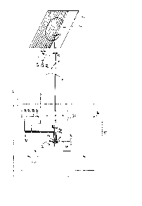
- figure l i5 a diagram of the principle of a
device corresponding to the in~ention and its
implementation:
- figure 2 is a diagram of ~he principle of
the detection of the edges of the Earth;
- figure 3 is a diagram illustrating the
implementation of two pairs of detectors;
- figure 4 is a graph showing the
corresponding signals obtained by an infra-red
detector and a detection of visible light;
- figure 5 i9 a diagram illustratinæ the
signals obser~ed by the detection elements for a
given band of ground.
DFTAI~D D~SCRIPTION OF THE PR~FERRFD FMBODIMENTS
The example described below concerns in
particular meteorological obser~ation s2tellites.
Such a ~atellite schematized as S contains an
ob~er~ation system 10 or imager which scans
the image I of the Earth T and park of the
surrounding spaca.
The ~canning lines Ln are orientated
East-West, the line jumps (Ln to Ln+l) are made in
the North-South direction. The scanning axi3 X-X is
therefore orientated North-South. The movement of
attitude during the taking of an image must be
measured ~ery precisely.
The perp~ndicular compon0nes of the scanning
axi~ are measured in con~entional fashion by a
classic optical ~en~or ( solar or stellar)
~chematizcd as 11.
: :.,
. , ~ - ,
26~2~
The ob~ervation system or imager 10 con~lsts
of an optiGal scanning device 12 known in itself.
adapted, with reference to the scanning axis X-X, to
sorutini~e line by line the Earth T. In the focal
S plane P of this opt.ical de~ice 12 and along
the optical axi~ Z-Z of the latter i~ placed a
detection group 13 o~ any appropriate known typeJ
with which is as.~ociated a system 14 of formstion and
treatment of ima~es known in itself, adapted to read
for each point on the ground the value of the ei~na3.
and its date.
In the focal plane P are equally placed
~irst and second electroma~netic detection element~ 1
and 2 identical to each other, of any appropriate
known type ( adapted to react to incident radiation
of same sp0ctral characteristics, notably visible
li~ht and/or infra-red).
In the example in ~igure 1, these elements of
detection 1 and 2 are distinct ~rom the detection
group 13, one of these elemcnts (1) being situated on
the optical axis Z-Z These elements are, for
example, con~tituted each one by a detector.
The elemente of detection are separatHd .
parallel to the scanning axis Z-Z by a di3tance d
5 which is seen by the optical de~ice lZ from an angl~
equal to a complete multiple, at least equal to one,
of the angle ~ with which this optical de~ice sees
the distance ~ b~tween two conti~uous lines
Ln and l,n~1 intercepting the cele~tial body T.
: .
-lo- ~3~
The angles~and~ are, for example, aqual to each
other (in figure 1 the angle ~ has been artificiallY
enlarged for reasons of legibilty of the drawing)
To the d0tcction element~ 1 ancl ~ ar~
connected a davice for treatin8 and measurin~ the
angular ~elocity 15 comprising
- a circuit 16 adapted to form and ~elect
~ignals ~ and B (see figure 5 ) read succes~i~ely
(a~ well as th~ date~ of the points which constitute
them) by these detection 0lements, for a givsn band
of ground BT scanned on th~ Earth T, these ~ignals
being treated, if nece~sary. to correspond to the
~ame directional eeries along thi~ band (East-West,
or We~t-East);
lS - a circuit 17 adapted to detect in each of
these signals ~ and B a characteristic transition ~1
and B1 representatlve of a gi~en characteristic point
of the band of ground under consideration (for
example, the inter~ace ~poce~atmosphere and/or Earth,
or any other geographic d0tail cau~ing a marked
contra3t such a~ a transition batween a stretch o~
wat~r and solid ground, or riv0r~ or gorge..... )i
- a circuit lB adapt~d to r~ad the relati~e
po~ition of each transition ~1 or B1 in relation to
signal ~ or B ( by re~erenc0, for example. to the
lsft extremity o~ each signal); and
- a computation circuit 19 adaptad to
determine, grom ~om0 div~rg~nc~ ~ bstwe0n tha~e
relative PsitiOn~. the angular velocity ~a
: . : . . :
326529
if any of the satellite, taking account of the
inter~al of time existing between the instants
where each of the discontinuities ~1 and B1 ha~ been
read.
The constitution of these circuits poses no
difficultie~ for the men skilled in the art gi~n the
preceding instructions and will not be detailed
further here. ~,
In effect, in the ca~e under consideration
where ~ and ~ are equal and where a gi~en band of
ground iB obser~ed by tho detection elements 1 and 2
in the course of ~uccessive scanning of two adjoinin
lines, if one ~easures the instant of pas~age of
the signal from the datectors 1 and 2 by a fixed
threshold V corresponding, for example, to the
transition between space and the Earth ( in passing
through the atmosphere), or more generally between
two very different luminous zones in the image, one
obtaino in ths course of each line, for the second
20 detector 2, a signal (~) which repsats itself "a ~ .
priori" to the identical as ~B) on the first detector
when same scans the following line Ln+l . This
repetition permits one to follow constantly the~drift
of the attitude around the scanning axis, which
permits one to readdust the gyrometer, that is to sAy
to annul the measured drift, for example in the ca~e
of a gyrometer in the satellite.
The invention is applicable in the ca~e where
the scanning of a line i~ in3tantaneou~ or
; ;~;, . : ,
-12- 132~29
sufficiently rapid so that the mo~ement of the
atmosphere ~moving element in the sighted obJect) is
negligible during th.is .scannin~ time.
In figure 2 where the atmosPhere is partial~.y
represen~.ed by an irregular line ~TM, the ~ertical
arrows symbolise the detection of the edge of the ..
earth ~1 or ~l, as well as ~'1 read by detector 2
whil3t detector 1 scrutinises an adJoin~n~cg line.
To avoid ths di3appearance of clear
thresholds, that is to 3ay a steep gradient, in the
neighbourhood of the poles, detectors 1 and 2 are
3ub-divided into two pairs (1, 2, and 1', 2' on
figure 3) each pair be.ing in its whole offset within
th~ focal plane ln relat.ion to the optical axis
toward3 the North or towards the South, which has the
effsct of off~etting too the l.ine of sight. In
thi3 way, when the North of the image starts to be
scanned, the pair with the l.ines of sight offset or
adjusted towards the South will dctect the
intersections space~arth sufficientlY to the South
of the North pole so that the tran3itions ars clear.
In the same way, when the South of the image
is scanned one uses the pair with lines of- sight
ad,justed towards the North.
- In the ~icinity of the rniddle of the image,
one swings from one pair to tha other 3uccessively,
using the following pair3 of detectors:
- 1 and 2 (nominal confi~uration)
- then 1 and 2' ( transition stage: one
-13- 132~52~
compare~ th0 thr0~hold of d0tector 1 and that of
detector 2' of th~ proceding line)
- thsn 1' and 2' (other nominal configuration,
on~ compar~s the thrashold of datector 1' with that
of det0ctor 2' on the preceding lin~).
Th~ wa~l~ngth used for det~ctor~ 1, 2, 1',
2', is prafarably close to th0 infra-red ~o as to
obtain a strong contrast aarth/space~ a~an wh~n the
Earth is not lit by the Sun. In practica th~
wavelangth u~0d may be, very generally, ~ho~an from a
wide spactral band.
La~tly, each pair of det0ctor~ is in fact
constitut0d of two groupQ of detectors to a~suro the
redundance of their function.
Tha inten~ity-distance cur~e in fi~ure 4
shows the results of a simulation u~ing imaga data
from ~ETE OST~T.
One distinguisha~ claarly on it tha~
transition Earth~spaca A1 or B1 for th0 inFra-red
dat~ctor3, and ~'l1 or B"1 for th0 vi~ible wa~0length
d0tectors, 10ss effecti~e At night.
One notes that th~ utilisation o~ the
optical in3trum~nt 10 .its01f p0r-nit dispensing ~ -
with a s~cond optics a~ in known solutions, and with
any oth0r sensor (Sun, ~tars) ful~illing the samc
function of msa~ur~ment of angular ~01Ocity around
th~ axi3 X-X. Th0 combination of two det0ctors
p0r~it~ ind~pendenca from the rotundity of the 0arth
and from fluctuation~ of th0 at~o~ph~r~.
.
:: , : :
: , .:
:, ~ . , .
:: : . , ~; : :
1~2~2~
-14-
It goe~ without sayin~ that the preceeding
descrip~ion has only been propo~ed by way of a
non-restrictive example and that numerous
~ariants can be proposed by an expert without
de~iating from the framework of the in~ention.
So for example, one will appreciate thak th0
reasoning shown as to figure 5 is independent of
the direction in which the considered band of ground
is scanned for the consti~l~tion of signal ~ then
~ignal B, ~hich is comPatible with scanning in
alt~rnate directions.
In variation, the an~le ~ i~ an e~0n multiple
of ~ , equal for example to 2 in which cao0,
~hate~er the direction of ~canning ~ucces~i~0 lin0s,
one can forecast that the time s0parating transition~
~1 and B1 should be in theory, in the ab~enc0 of
angular ~elocity, a multiple of the duration of
: ~ scanning of each line.
Further, the position~ of the detection
element~ 1 and 2 can be in~erted in which cas0 the
chronological order of signals A and B is in~erted,
which does not change in substance the principle of
the in~0ntion.
The ~ignal of speed produced by the treatment
: 2S de~ic0 15 can b0 u~ed to ~ery div0r~e ends, notably
for the control of attitude of the ~atellite with the
assi~tance of known cla~sic mean~ utilised to thi~
eff0ct tnozzle~.. ).
. ~ . .
~, .