Note: Descriptions are shown in the official language in which they were submitted.
1 337~25
This is a divisional application of copending application
590,761, filed February 10, 1989.
The present invention relates to a current location
~ displaying apparatus in which a path of travel of a vehicle,
such as an automobile, is displayed on a display screen with
a map displayed thereon.
In an attempt to provide guidance to a driver of an
automobile to prevent the driver from loosing his way while
driving, for example in a strange place, a current location
display apparatus has been developed. In this apparatus the
distance travelled and direction of travel of the vehicle are
detected from time to time, and the current location of the
vehicle on a two-dimensional coordinate system is
successively computed from the results of the detection,
whereby the current location of the vehicle is successively
displayed on a map, which is previously displayed on the
screen.
In such an apparatus, it is difficult to avoid the occurrence
of a positional error owing to accuracy of detection at the
time of detecting the distance and the direction during
running of the vehicle, and such positional error is
progressively integrated, as the vehicle continues on its
~`
'~
1 337~2J
course with the result the current location on the map
appears to run off the road and the driver becomes unable to
see where he is driving.
It has been usual practice to correct this positional error
by matching the road pattern with the trajectory of the
vehicle, which is obtained by storing and holding data of the
successively changing current locations as the vehicle
continues its course, thereby enabling correction of the
current location which has gone off the road. According to
this method a plurality of roads, which are considered to be
the roads through which the vehicle has passed are selected
from a complicated road network, and adaptability of the
pattern of each of the extracted roads and the trajectory is
examined. Then the road having highest matching rate is
- la -
133~825
assumed to be the road where the vehicle is actually
travelling and the correction in position is effected to
bring the current location of the vehicle comes onto the road
to which the matching has been effected.
In such a method, if the map includes complicated roads, a
considerable number of road patterns must be matched to the
actual trajectory. It is, therefore, necessary to effect
matching of the pattern of the travel path to each of the
road patterns, and so the processing becomes very complicated
and requires considerable time. This method has the further
disadvantage that if the vehicle passes through a road which
does not exist on the map, the pattern matching cannot be
effected, with the result that the correction of the current
location becomes impossible.
In view of the disadvantages of the prior art, the present
invention provides a current location display apparatus in
which a current location of the vehicle which has come off
its course is corrected by effecting matching of the pattern
of a road on a map and the pattern of a travel path of the
vehicle, which permits processing to continue even if the
vehicle temporarily passes through a road which does not
exist on the map, and to effectively and precisely effect
matching between a road pattern and a travel path pattern.
According to an aspect of the present invention there is
provided an apparatus for displaying a current location of a
running body in which a continuously changing location of the
running body on X-Y coordinates is successively computed and
a current location of the running body is displayed, in
accordance with data thus computed, on a display screen
having a map previously displayed thereon, comprising: means
for detecting running distance and moving direction of the
-- 2
1 337825
running body; means for calculating a current location from
the running distance and the moving direction and obtaining a
travel path; means for extracting a linear running portion
from the travel path of the running body obtained by storing
and holding data of the current location thus obtained; means
for extracting a linear road portion from a predetermined
area on the map which corresponds to the extracted linear
running portion; means for effecting matching between the
extracted linear running portion and the extracted road
portion by comparing the extracted linear running portion and
the extracted road portion and determining whether a
positional relationship therebetween is satisfied; means for
bringing the current location into line with the road to
which the matching has been effected; means for effecting
coordinates transformation to transform the linear running
portion extracted from the travel path and the linear road
portion extracted from the road on the map in correspondence
with said linear running portion on a first coordinate system
into points on a second coordinate system; and means for
effecting the matching between the linear running portion and
the linear road portion on said second coordinate system,
wherein the coordinates transformation is effected by using
Hough Transformation.
According to a further aspect of the invention there is
provided an apparatus for displaying a current location of a
running body in which a continuously changing location of the
running body on X-Y coordinates is successively computed and
a current location of the running body is displayed, in
accordance with data thus computed, on a display screen
having a map previously displayed thereon, comprising: means
for detecting running distance and moving direction of the
running body; means for calculating a current location from
the running distance and the moving direction and obtaining a
1 337~25
travel path; means for extracting a linear running portion
from the travel path of the running body obtained by storing
and holding data of the current location thus obtained; means
for extracting a linear road portion from a predetermined
area on the map which corresponds to the extracted linear
running portion; means for effecting matching between the
extracted linear running portion and the extracted road
portion by comparing the extracted linear running portion and
the extracted road portion and determining whether a
positional relationship therebetween is satisfied; and means
for bringing the current location into line with the road to
which the matching has been effected; wherein the means for
extracting the linear running portion includes (a) means for
ascertaining if a change in running direction is
substantially zero at the time when the running body has
moved for a predetermined distance from an initial position,
(b) means for imposing an imaginary straight line in a
running direction of the running body from the initial
position, (c) means for determining a distance between the
current location of the running body and the imaginary
straight line, and (d) means for deciding that the running
body is running on a straight line on the basis that as long
as the distance between the current location of the running
body and the imaginary straight line is shorter than a
predetermined value, the running body is running on a
straight line and the linear running portion is extracted
therefrom.
According to a still further aspect of the invention there is
provided an apparatus for displaying a current location of a
running body in which a continuously changing location of the
running body on X-Y coordinates is successively computed and
a current location of the running body is displayed, in
accordance with data thus computed, on a display screen
- 3a -
1 337825
having a map previously displayed thereon, comprising: means
for detecting running distance and moving direction of the
running body; means for calculating a current location from
the running distance and the moving direction and obtaining a
travel path; means for extracting a linear running portion
from the travel path of the running body obtained by storing
and holding data of the current location thus obtained; means
for extracting a linear road portion from a predetermined
area on the map which corresponds to the extracted linear
running portion; means for effecting matching between the
extracted linear running portion and the extracted road
portion by comparing the extracted linear running portion and
the extracted road portion and determining whether a
positional relationship therebetween is satisfied; and means
for bringing the current location into line with the road to
which the matching has been effected; wherein the means for
extracting the linear road portion includes (a) means for
defining an area by parallel lines having a predetermined
width therebetween on both sides of the linear running
portion extracted from the travel path, and (b) means for
determining whether a linear road portion has (i) a
predetermined minimum length and (ii) a running direction
which falls within a predetermined range.
The invention will now be described in more detail, by way of
example only, with reference to the accompanying drawings in
which:-
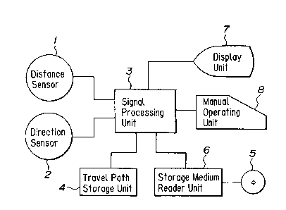
Fig. 1 is a block diagram showing an embodiment of thecurrent location display apparatus according to the present
invention;
Fig. 2 shows an example of the display produced by the
- 3b -
1 337825
embodiment shown in Fig. l;
Fig. 3 shows the status of the display where the travel path
has come off the road on the map;
Fig. 4 is a flow chart showing the process of extracting a
linear travel segment;
Fig. S is a diagram showing an example of the travel path of
the vehicle to extract the linear trajectory;
Fig. 6 is a diagram showing a road searching area for
extracting the linear road segment;
Fig. 7 is a diagram showing an example of the travel path of
the vehicle relative to the map;
Fig. 8(a) is a diagram showing the linear trajectory taken
from the travel path shown in Fig. 7;
Fig. 8(b) is a diagram showing a proposed linear road segment
taken from roads on the map corresponding to the linear
trajectory;
Fig. 9 is a diagram showing a straight line on X-Y
coordinates;
Fig. 10 is a diagram showing a point on e-gamma coordinates
according to Hough Transformation;
Fig. 11 is a diagram showing combinations of four linear
trajectories; and
Fig. 12 is a diagram showing combinations of proposed linear
- 3c -
1 337~25
road segments on the map depending upon the selected
combination of the four linear trajectories.
In the accompanying drawings, Fig. 1 shows an embodiment of
the fundamental construction of the current location display
apparatus according to the present invention.
The essential components comprise a distance sensor 1 of
photoelectric, electromagnetic, mechanical contact type or
the like, for generating pulse signals corresponding to the
distance travelled of the vehicle, depending on the rotation
of the wheels of said vehicle, for example; a direction
sensor 2 for generating signals proportional to the amount of
change of direction of the vehicle, consisting of a gyroscope
for detecting change in the yaw angular velocity, for
example; a signal processing unit 3 for counting the number
of the pulses sent from the distance sensor 1 to measure the
distance travelled of the vehicle and to determine the change
of course of the vehicle on the basis of the output signal of
the direction sensor 2 to successively compute the current
location of the vehicle on the two-dimensional coordinates at
every unit distance of travel to effect centralized control
of the whole system, the unit 3 including a CPU, a
programming ROM, a controlling RAM, etc.; a travel path
storing means 4 for successively storing the data of the
constantly changing location on the two-dimensional
coordinates obtained by the signal processing unit and
holding the data as finite and continuous location
information corresponding to the current locations of the
vehicle; a map information storage medium 5 in which a
plurality of file units of map informations are previously
stored; a storage medium reader unit 6 for selectively
reading out the desired map file from the storage medium 5; a
display unit 7 for displaying a map on a display screen in
accordance with the read-out map information and renewably
displaying the current locations of the vehicle, the travel
path, and current course and other information on the same
1 337~25
display screen on the basis of the location data stored in
the storage unit 4, and a manual operating unit 8 for giving
a command for operation to the signal processing unit-3 and
for effecting various operations including selection of the
map to be displayed on the display unit 7, setting of the
starting point of the vehicle on the displayed map, change of
directions of the displayed map and the trajectory, shifting
of the displayed position, change of the setting of the
display such as the partial enlargement of the display of the
map and the travel path, selection of the reduced scale and
the like.
In the construction as described above, the map, which has
been selectively read out, is displayed on the display unit
7, as shown in Fig. 2., and a display mark Ml indicating the
current location of the vehicle on the X-Y map, depending
upon a predetermined map reduction rate previously set by the
signal processing unit 3 in accordance with the travel of the
vehicle from a starting point set on the map, a display mark
M2 indicating the direction of travel at the current
locations and a display mark M3 indicating the trajectory
from the starting point S to the current location are
simulatively displayed thereon, depending upon the running
status of the vehicle.
The above-described construction and its operation are the
same as those of the known travel path display apparatus as
hereinbefore described. Accordingly, this travel path
displaying apparatus has the disadvantage that the current
location and the travel path increasingly come off the road
on the map as the vehicle proceeds, owing to the integrated
error described above, as shown in Fig. 3 until the driver
becomes unable to see where he is driving on the map.
In order to avoid such disadvantage, the current location
display apparatus according to the present invention
comprises means for extracting a linear travel segment from
1 337g25
the travel path of the moving body, means for extracting a
linear road segment from adjoining roads on a map which
corresponds to the extracted linear travel segment,.means for
effecting a matching between the extracted linear travel
segment and the extracted linear road segment in accordance
with the positional relationship thereof and means for
bringing the current location into line with the road to
which the matching has been effected.
In practice, these means are executed in the signal
processing unit 3. The means for extracting a linear travel
segment from the travel path of the vehicle is executed in
the following manner. The processing thereof is shown by the
flow chart of Fig. 4.
Firstly, an initial position A and a direction of travel eO
at the position of the moving body, as shown in Fig. 5, are
memorized and then a direction of travel e, at the time when
the moving body has moved a preset distance Ll is determined.
A variation delta e of the direction of travel at this stage
is calculated (deltae = ¦e~ -eol).
Next, the variation delta e of the direction of travel and a
preset threshold value eth are compared with each other. If
delta e < eth~ it is determined that the direction of travel
at this time is stable and the vehicle is moving along a
straight line, whereas if delta e >= eth, it is determined
that not moving along a straight line. If it is determined
that the vehicle is moving along a straight line, a supposed
straight line A-A' is drawn from the initial position A in
the direction eO and a distance d between the current
location P of the vehicle and the supposed straight line A-A'
is found.
The found distance d and the preset threshold value D are
compared with each other. As long as the relation d < D is
met, it is determined that the vehicle is continuously moving
1 337825
on the straight line. The value of D is set in such degree
that it is not effected by a change of traffic lane. When
the relation becomes d >=D, it is supposed that the.
travelling of the vehicle on the straight line has
terminated. Then, the travel distance on the straight line
Lx between the current location P of the moving body and the
initial position A is found and the found travel distance on
straight line Lx and the preset threshold value Lth are
compared with each other. If Lx > Lth, it is assumed that a
linear travel segment having a length longer than a
predetermined value has been detected and the respective
positions on the coordinates of an starting point and an
terminating point of the linear travel segment are memorized.
If LX =< Lth, it is assumed that the linear travel distance
of the vehicle is short and this linear travel segment is
excluded, and it is not subjected to the matching process.
The same steps are repeated and the linear travel segments
are successively detected as the travel path proceeds. In
this case, the linear travel segment having a distance
shorter than a predetermined value is not subjected to the
matching process. However, it is possible to set the
threshold value Lth stepwise so that the threshold value can
be set at a lower value in the case where the vehicle is
running on a curved mountain road, for example, so that the
shorter linear travel segment may be subjected to the
matching process.
The means for extracting the linear road segment from the
adjoining roads on the map which corresponds to the linear
travel segment extracted from the travel path is executed in
the following manner. When a linear travel segment a-b is
detected from the travel path of the vehicle, as shown in
Fig. 6, a road searching area W having a width of 2R is
defined by parallel lines on both sides of the linear travel
segment a-b. Within this area W, a linear road segment
1 337825
having a predetermined minimum road length L min and defined
by lines having difference in angle relative to the linear
travel segment a-b within a threshold value ~ is extracted.
Now, it is assumed that the travel path of the vehicle
relative to the road in the map is as shown by a broken line
in Fig. 7.
According to the present invention, firstly linear travel
lines 11, 12, 13, and 14 are extracted from the travel path,
as shown in Fig. 8(a).
The segment between the points b and c, in Fig. 8(a),
indicates that the vehicle moves on a road which is not shown
on the map. The segments d-e and f-g indicate that the
vehicle curves at intersections.
Then, proposed linear road segments ml.1 and ml.2, which
correspond to the extracted linear travel segment 11,
proposed linear road segments m2.1 and m2.2, which correspond
to the extracted linear travel segment 12, a proposed linear
road segment m3.0, which corresponds to the extracted linear
travel segment 13, and a proposed linear road segment m4.0
which corresponds to the extracted linear travel segment 14
are extracted respectively, as shown in Fig. 8(b).
Then, the matching rate between each of the extracted travel
path segments and each of the extracted road segments is
found from the positional relationship therebetween. The
found matching rate is compared with a predetermined
threshold value. The linear road segment having the matching
rate larger than the threshold value is determined as the
optimum one for the proposed linear road segment, and the
linear travel segment in the travel path, which corresponds
to the optimum one of the proposed linear road segments is
brought into line with the linear travel segment.
1 33~ ~2~
If a plurality of linear road segments, having the matching
rate higher than the threshold value are found, the optimum
one of the proposed road segments is not determined.at this
time, and the decision is effected depending upon the
matching process of the succeeding linear segments, according
to a so-called indecisive algorithm.
A coordinate transformation may be effected to indicate a
straight line on X-Y coordinates by points on the e - gamma
coordinate, according to Hough Transformation, for example,
the respective points corresponding to the linear segments
extracted from the travel path and the road on the map are
subjected to the matching process, and the positions of the
points on the e - gamma coordinates are adopted as
characteristic values to which the matching process is
effected. In this coordinate system, e is the angle of a
perpendicular drawn from a straight line on the X-Y
coordinates to an origin of the coordinates and gamma is the
length of the perpendicular. For example, a straight line L
on the X-Y coordinates shown in Fig. 9 is expressed by a
point el on the e-gamma coordinates, as shown in Fig. 10.
In this case, therefore, the matching process can be easily
effected by simply comparing the positions of the respective
points corresponding to the linear segments extracted from
the travel path and the road on the map.
It is, of course, possible to directly subject the linear
segments extracted from the travel path and the road on the
map to the matching process so that the matching is effected
on the basis of the characteristic amounts including the
positions on the X-Y coordinates, the length, the inclining
direction, the inclining angle, etc. but in such case many
characteristic values to be subjected to the matching process
are included and, therefore the matching process is
troublesome.
1 337825
The above matching process is collectively effected every
time a predetermined number of the linear travel segments
extracted from the travel path have been obtained as the
vehicle proceeds on its path.
Now, it is assumed that the matching process is collectively
effected very time four linear travel segments have been
extracted from the travel path, for example. In this case,
the relationship is as shown in Fig. 8 and the combination of
the selected four linear travel segments 11 - 14 is as shown
in Fig. 11.
This case includes the combination of (24-1) from the case
where all of 11 - 14 are selected to the case where only one
of 11 - 14 is selected.
For example, it is assumed that the vehicle is running in
such a state that the linear travel segment 13 of the travel
path is on a road which is in parallel with a proposed linear
road segment and is not shown in the map. Then, the linear
travel segment 13 is not selected and the combination
includes the linear travel segments 11, 12 and 14.
Such a combination of the proposed linear road segments on
the map is effected. Depending upon the selected combination
of the linear travel segments of the travel path.
For example, the combinations of the proposed linear road
segments on the map corresponding to the combination of
selection of the linear travel segments 11, 12 and 14 of the
travel path includes four sets ~ - ~ as shown in Fig. 12.
The matching process is executed on combinations including
the selected combinations of the linear travel segments 11 -
14 and the combinations of the proposed linear road segments
on the map.
-- 10 --
1 337825
Good precision of matching is obtained by executing the
matching process on all of the combinations. However, it is
not always necessary to execute the matching process on all
combinations, and the matching process may be executed on
properly selected combinations.
Further, it is not always necessary to collectively effect
the matching process. It is, of course, possible to
successively execute the matching process as the linear
travel segments are extracted from the travel path.
When the travel path is brought into line with the road to
which the matching has been effected, it is possible to
individually and successively bring the linear travel segment
extracted from the travel path into the optimum one of the
linear road segments to which the matching has been effected.
In the case where the matching process is collectively
effected, it is possible to calculate an average of vectors
including the differences in direction between the
corresponding linear travel segments and linear road segments
and the sizes of these segments, and to displace a group of
the linear travel segments by a predetermined distance in a
predetermined direction, depending upon the calculated
average of the vectors.
Thus, it will be understood that the present invention
provides an apparatus in which the matching between the
travel path of the vehicle and the road on the map can be
easily and precisely effected, with a small amount of
information, by a partial matching process of the linear
segments so that the load applied to the signal processing
unit 3 is decreased and the matching process can be effected
at high speed.
When the coordinate transformation, for example, a Hough
transformation is applied to transform the linear segments
extracted from the travel path and the road on the map into
1 33782~
the points, it is possible to effect the matching process by
simply comparing the positions of the points on the map,
which is more advantageous,
Furthermore, in the apparatus of the present invention, the
S matching between the travel path and the road on the map is
effected on the basis of the discontinuous linear travel
segments extracted from the travel path without requiring a
process for searching related road segments as in the
conventional apparatus, so that even if the vehicle runs on a
road which is not shown on the map, the matching process can
be effected without being affected thereby.
According to the present invention the collective process is
effected on the combination in which the linear travel
segment extracted from the travel path is assumed to be
located outside of the road shown on the map, and accordingly
the travel segment outside the road on the map is
automatically cancelled at the time of effecting the matching
process so that precision of matching is improved.
Furthermore, according to the present invention, a
deformation of the map at a curved portion does not affect
the matching process of the present invention, and with
regard to deformation of the map at a straight segment, the
matching rate is rather improved by cancelling the
deformation. Thus, resistance to deformation of the map is
increased. For example, a map of a town in which a detailed
road map is shown and another map of a suburb in which only
main roads are shown have no corresponding relation with each
other. In such a case, the present invention can be
effectively applied since it does not depend upon the
interrelation between one map and another.
Thus, the present invention provides a current location
display apparatus in which a linear travel segment is
extracted from a travel path of a vehicle while a linear road
- 12 -
1 3~7S325
segment corresponding thereto is extracted from a road on a
map; a matching process is effected between the extracted
linear travel segment and linear road segment depending upon
a positional relationship therebetween, and the current
location is brought into line with the road to which the
matching has been effected.
Accordingly, the processing is not interrupted even if the
vehicle tentatively comes off a road on a map and the
matching process is effected always in an optimum manner so
that the travel path of the vehicle on the map is displayed
with high precision.
- 13 -