Note: Descriptions are shown in the official language in which they were submitted.
- Z1J;~ ?2~ 4
The invention concerns controlling the orbit of
space vehicles such as satellites and is more
particularly directed to space vehicles in geostationary
orbit (in which case the expression "stationkeeping" is
S usually used as a synonym for "geostationary orbit
control").
The position and speecl of a satellite in orbit
can be deduced from a known state vector E formed from
six orbital parameters such as, for example:
- the major half-axis of the orbit, usually designated
a;
- the eccentricity vector defined in the plane of the
orbit by its coordinates:
ex = e.cos
. ey = e.sin~
where e is the eccentricity of the orbit (dimensionless
parameter) and ~ is the argu~ent of the perigee;
- the inclination vector of the orbit defined by its
coordinates:
~ ix = i.cosS2
. iy = i.sinS2
where i is the inclination tin degrees), that is to say
the angle of the plane of the orbit relative to the
terrestrial equator, and ~ is the right ascension of the
ascendant node (which designates the orientation of the
line of nodes relative to any predetermined inertial
frame of reference);
- the mean longitude lm
If the satellite was subjected only to the
gravity field of a homogeneous and perfectly spherical'
Earth the orbital parameters of the state vector E would
remain constant (a = 42.164 km, ex = ey = 0 and
ix = iy = 0, lm = parking - or set point
longitude) and the satellite would remain strictly
geostationary.
~k .
.~ . ~ ,. .
~: .
2~ 2~
However, because of disturbances due in
particular to the non-spherical shape of the Earth and
the non-homegenous nature of terrestrial gravity, the
attraction of heavenly bodies such as the Sun and the
Moon and solar pressure forces, the orbital parameters
change slowly.
The function o~ a geostationary satellite
requires in practice that it be held in a narrow window
in terms of longitude and latitude (with a width
10typically between 0.05 and 0.1 degree). This requires
correction (or "stationkeeping") manoeuvres which are
currently computed and trans~itted to the satellite by
one or more control stations on the ground and based on
measurements by means of antennas on the ground.
15Stationkeeping therefore requires at present a
permanently manned infrastructure on the ground (24
hours a day, 365 days a year), resulting in high
satellite operating costs. This problem is co~pounded
by possible problems with the availability of a suitable
location for constructing a control centre and with the
need to make it secure.
The object of the invention is to enable
autono~ous computation on board the satellite of the
orbital parameters and the stationkeeping manoeuvres to
be executed so that it is possible to dispense with
continuous assistance from the ground and to involve a
control centre on the ground only occasionall~.
To this end the invention proposes a station-
keeping method for a satellite in geostationary orbit
characterised in that:
- there are determined at the same time the angle ~1
between the satellite-Sun direction and the
satellite-Earth direction and the angle a2 between the
satellite-Pole Star direction and the satellite-Earth
direction,
.
.
:' ' ~ ' '
- Z~Q2~
- there is deduced therefrom a state vector E consis-
ting in orbital parameters by the formula:
Z = H.E + C.B
where:
. Z is a measurement vector the components of
which are deduced from the angles al and a
. H is a measuring matrix,
. C is a bias sensitivity matrix of the form
l Xs Ys
where Xs is a term corresponding to a
O O Yp
period substantially equal to one day, Ys is a term
corresponding to a period substantially equal to one
year and Yp is a term characteristic of the movement
of the Pole Star,
. B is a bias vector determined beforehand by
comparison of the measured vector Z and measurements
made on the ground,
- stationkeeping manoeuvres are determined consequently
and applied by means of thrusters.
Thus in accordance with the invention the
position of the satellite in space is characterised by
the angles of the Sun and the Pole Star to the Earth as
seen from the satellite.
The angles al and a 2 are preferably
determined from measurements effected by at least one
terrestrial detector , a plurality of solar
detectors and a stellar detector
oriented towards the North along the South-North axis of
the satellite, the measurements from these detectors
being filtered separately so as to obtain
for these measurements an overall time-delay (detector
intrinsic time-delay plus filter time-delay) that is
exactly the same.
The invention also proposes a stationkeeping
~ . '
:, ..
, . ' '' ~"'', .
. ~
2~
system comprising:
- at least one terrestrial detector provided with
a filter adapted to generate a time-delay such that
the overall time-delay (detector intrinsic time-delay
plus filter time-delay) has a predetermined value,
- a plurality of solar detectors
provided with a filter . adapted to generate a
time-delay such that the overall time-delay is equal to
said predetermined value,
- at least one stellar detector oriented towards the
North along the South-North axis of the satellite
provided with a filter adapted to generate a
time-delay such that the overall time-delay is equal to
said predetermined value,
- a position computation unit connected to these
filters and adapted to deduce from the filtered
measurements from said detectors
the angle ~1 between the satellite-Sun direction and
the satellite-Earth direction and the angle a2 between
the satellite-Pole Star direction and the satellite-
Earth direction,
- an orbital parameter computation unit connected
to the output of the position computation unit
and adapted to determine the state vector E of the
satellite made up of orbital parameters according to the
formula:
Z = H.E + C.B
- a bias computation auxiliary unit connected to
the output of the position computation unit , to a
telemetry unit in communication with the ground an~
the output of which is connected to the orbital
parameter computation unit, adapted to determine and
memorise the bias vector B by comparing the vector E
with corresponding measurements from the ground, and
- a control unit connected to stationkeeping
,.~. .,. ^ - :
,; , .
.:: ; , . .
.. , . . ~ . .. . .
,
, ~ , . .
20002 1 4
thrusters.
In one aspect, the present invention provides a
stationkeeping method for a satellite in geostationary orbit
comprising the steps of: determining at the same time the
angle ~1 between the satellite-Sun direction and the
satellite-Earth direction and the angle 2 between the
satellite-Pole Star direction and the satellite-Earth
direction, deducing therefrom a state vector E consisting in
orbital parameters by the formula:
Z = H.E + C.B
where Z is a measurement vector the components of
which are deduced from the angles al and 2~ H is a
measuring matrix with a number of lines equal to the number
of said components in Z and with a number of columns equal
to the number of said orbital parameters in E, C is a bias
sensitivity matrix of the form
'~Xs YS ~
O O Y
`
where Xs is a term corresponding to a period substantially
equal to one day, Ys is a term corresponding to a period
substantially equal to one year and Yp is a term
characteristic of the movement of the Pole Star, B is a bias
vector determined beforehand by comparison of the measured
vector Z and measurements made on the ground, determining
stationkeeping manoeuvers from vector E and applying same by
means of thrusters.
In another aspect, the present invention provides
a stationkeeping system comprising: at least one detector
provided with a filter adapted to generate a time-delay such
that the overall time-delay (detector intrinsic time-delay
5a 200021 4
s plus filter time-delay) has a predetermined value, a
plurality of solar detectors provided wi~h a filter adapted
to generate a time-delay such that the overall time-delay is
equal to said predetermined value, at least one stellar
detector oriented towards the North along the South-North
axis of the satellite provided with a filter adapted to
generate a time-delay such that the overall time-delay is
equal to said predetermined value, a position computation
unit connected to these filters and adapted to deduce from
the filtered measurements from said detectors the angle 1
between the satellite-Sun direction and the satellite-Earth
direction and the angle 2 between the satellite-Pole Star
direction and the satellite-Earth direction, an orbital
parameter computation unit connected to the output of the
position computation unit and adapted to determine the state
vector E of the satellite made up of orbital parameters
according to the formula:
Z = H.E + C.B
where Z is a measurement vector the components of
which are deduced from the angles ~1 and ~2~ H is a
measuring matrix with a number of lines equal to the number
of said components in Z and with a number of columns equal
to the number of said orbital parameters in E, C is a bias
sensitivity matrix of the form
~Xs Ys
~ 0 Y~ .
where Xs is a term corresponding to a period substantially
equal to one day, Ys is a term corresponding to a pericd
substantially equal to one year and Yp is a term
characteristic of the movement of the Pole Star, B is a bias
3s vector determined beforehand by comparison of the measured
vector Z and measurements made on the ground, a bias
- .
~ -
20002 1 ~
computation auxiliary unit connected to the output of the
position computation unit and to a telemetry unit in
communication with the ground, the output of said bias
computation auxiliary unit being connected to the orbital
parameter computation unit, adapted to determine and
memorize the bias vector B by comparing the vector E with
corresponding measurements from the ground, and a control
unit connected to stationkeeping thrusters.
According to preferred features:
- an attitude determination unit is connected to the outputs
of the terrestrial, solar and stellar detectors and to the
output of the orbital parameter computation unit,
- the orbital parameter computation unit is a KALMAN filter,
- the bias computation auxiliary unit is a FRIEDLAND filter.
Objects, characteristics and advantages of the
invention will emerge from the following description given
by way of non-limiting example only with reference to the
appended drawings in which:
- figure 1 is a schematic view of a satellite equipped with
an autonomous orbit control system in accordance with the
invention;
- figure 2 is a simplified schematic view of this autonomous
geostationary orbit control system; and
- figure 3 shows the simulation over one year of the path of
a satellite of this kind.
Figure 1 shows schematically a satellite 1 in an
orbit 2 about the Earth.
The satellite 1 is conventionally associated with
a frame of reference X Y Z in which the X axis is tangential
to the orbit 2 and oriented in the direction in which the
orbit is travelled (from West to East) and the Z axis is
directed towards the Earth (geocentric axis).
' ' .' . :~
- ,~
- '
.~ .
.
5c 20002 1 4
The satellite comprises a platform carrying solar
panels 3, reflectors 4 and propulsion thrusters of any
appropriate known type.
Also in the known way the platform of this
satellite comprises at least one terrestrial sensor oriented
towards the Earth and schematically represented
.
: , ~. . .
: ~ : . - - .
',,, . . ~:
at Tl together with a plurality of solar detectors
distributed in a plane parallel to the plane o the X
and Z axes and adapted to face the Sun successively as
the satellite completes its orbit Various
configurations are known; to give an example, there are
in this instance three solar detectors Sl. S2, S3
with one sensor S2 disposed on the side facing towards
the Earth and the other two sensors Sl and S3 n the
edges opposite this side.
In accordance with the invention the platform of
the satellite is also provided, in this instance on its
North side (opposite the Y axis), with a stellar detec-
tor P of any appropriate known type oriented towards the
North along the South-North axis. This is a detector
chosen from the SODERN or GALILEO range, for example.
As is kno~n, there are currently important
differences between the aforementioned three types of
detectors, even if they are all optical detectors.
Firstly, the solar detectors Sl through S3l
terrestrial detector Tl and stellar detector P are
classified in this order by decreasing incident radiated
power.
Also, these known detectors are sensitive to
different radiation spectra; the terrestrial detectors
are sensitive to infra-red radiation from-the Earth, the
solar detectors are formed of photo-electric cells and
the stellar detectors are based on rows or arrays of
charge-coupled devices (CCD).
Finally, these detectors conventionally comprise
integrated filters introducing different time-delays.
The invention exploits the fact that the Pole
Star is the only star of its magnitude to be always in
the field of view of a stellar detector mounted on the
North side of a satellite so that is recognition does
not require sophisticated software.
~,. . ~ . : .
,. . :
..
. ' . ' '~. " '
z~
The terrestrial detector Tl~ solar detectors
Sl through S3 and stellar detector P make it
possible to determine at any time the angular
orientation of the Earth, the Sun and the Pole Star in
the frame of reference related to the satellite.
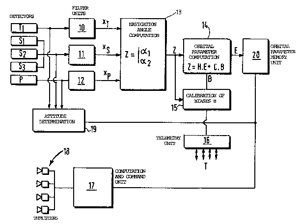
Figure 2 shows the structure of the autonomous
geostationary orbit control system.
Associated with the detectors Tlr S1 through
S3 and P are parallel ~ilter units 10, 11 and 12 in a
filter and synchronisation device the outputs of which
are connected to a position computation unit 13 followed
by an orbital parameter computation unit 14 with which
is associated a calibration auxiliary unit 15 also
connected to the position computation unit 13 and
connected to a telemetry unit 16 in communication with
the ground. The output of the orbital parameter
computation unit is connected to a computation and
command unit 17 controlling the stationkeeping thrusters
18. An attitude determination unit 19 is connected to
the unfiltered outputs of the detectors Tl~ S
through S3 and P and to the output of the orbital
parameters computation unit 14. In practice a unit 20
is associated with the computation unit 14 to store the
orbital parameters computed by the unit 14.
In practice the computation units 13, 14, 15,
17, 18 may be integrated into the onboard computer of
the satellite.
In accordance with the invention the position of
the satellite in space is characterised by measuring at
the same time the respective angular offsets al and
a2 between the Sun and the Earth and between the Pole
Star and the Earth as seen from the satellite.
The method of computing the angles al and
a2, which computation is performed by the computation
unit 13, is within the normal competence of those
.. .. _ .. . . , . . , ~ . .
: ~ . . . . . .
. , ,
,, , .. , . . ,. . ` .
.,, : ., ,:: . :;
-` Z~ Z~.9t
skilled in the art.
In outline, these computations may be summarised
as follows, where RT~ Rs and Rp denote frames of
reference respectively related to the terrestrial
detector, to the solar detectors and to the stellar
detector. It is known how to define ~atrices Ps and
Pp for passing from the frames of reference Rs and
Rp to the frame of reference RT. The measurement
from the solar and stellar detectors consists of a unit
vector Xs or Xp directed from the satellite towards
the Sun or the Pole Star.
Each of these vectors may be written in the
frame of reference RT:
XS = PS 1 . Xs
Xp = p -1 ~
and the navigation angles ~1 and ~2 deduced from:
cos al = ~'XT
cos ~2 = XP'XT
In practice, to obtain the measured angles ~1
and a2 at exactly the same time the invention proposes
during a first stage (at 10, 11 and 12) to filter
differently the raw measurements from the - various
detectors so as not only to obtain an appropriate
predetermined residual noise level but also to add a
time-delay differing from one detector to another and
such that the overall time-delay associated with each
detector (or group o~ detectors of the same kind), that
is to say the sum of the time-delay inherent to each
detector and the additional time-del-ay introduced by the
associated filter 10, 11 or 12, is the same for all the
measurements. This synchronises the measurements which
eliminates their influence on the attitude, which is
subject to variations that can be very fast.
The overall time-delay is chosen as equal to ten
seconds for example.
- 2~Q~
It is therefore possible to process at 13 a pair
of navigation angles with only a moderate period,
typically every ten minutes, which does not represent a
significant increase in load for the onboard computer.
Eet Z be a measurement vector constituted ~rom
the navigation angles ~1 and a~2-
The computation unit 14 is adapted to deduce the
state vector E combining the orb~ital parameters from a
formula of the type:
Z = H.E + C.B
where H is a measurement matrix,
B is a bias vector,
and C is a bias sensitivity matrix of the
type:
/XS Ys \
- C= ..
O O Yp/
where Xs is a term corresponding to a period
approximating one day, YS iS a term
representing a period approximating one
year and Yp is a term representing a
period approximating the apparent movement
of the Pole Star.
Determining the components of the measurement
25 matrix H is within the normal competence of those
skilled in the art, given the definitions selected for
the vectors Z and E.
The same goes for the components of matrix C.
In the following example there have been chosen
for the vectors 2 and E definitions slightly different
to those given hereinabove:
_ Z = (COS Xl - COs Xlsyn, ' X~ X2syn)
where the subscript "syn" is associated with the value
of the parameter xl r x2 for the satellite assumed
to be in an ideal, non-disturbed geosynchronous orbit
: :
: -
- ~
200021 4
and where the superscript "T" indicates a vector or matrix
transposition;
- E = (~, ~, ex, ey, ix, iy)T
where
~ = a-aSyn
~ = ~ + b~ + M-lm
ex = e.cos (n+~)
ey - e.sin (a+~)
ix = i.cosn
iy = i.sinn
with M denoting the mean anomaly, e denoting the
eccentricity of the orbit, ~ denoting the argument of the
perigee; and a denoting the major half-axis of the orbit;
- the matrix H is then writtenrH~
~H2J
Hl = 1 0,xl.sin 1 - yl.cos 1, (l-cos 21).xl - sin 21.yl,
-xl.sin 21 + (1 ~ cos 21).yl, -~ .sin 1, z .cos 1]
and
H2 = 1 [O,x2.sin 1 - y2.cos l,(l-cos 21).x -sin 21-y ,
sinx
2syn
-x2.sin 21 + (l+cos 21).y2,-z2.sin 1,z2.cosl]
where 1 = lm (parking longitude) + ~ (sidereal time),
(xl, Yl~ Zl) is the unit vector (Earth-Sun centre)
and
(x2, Y2~ Z2) is the unit vector (Earth-Pole Star
centre).
The parameters Xs~ Ys and Yp of matrix C
correspond to the coordinates of the sa~.e unit~ vectors
if, changing the previous notation, these coordinates
are written (Xs~ Ys~ Zs) for the Sun and (Xp,
Yp, Zp) for the Pole Star.
As already explained, the form of H depends on
the precise form chosen for Z and E.
- The object of the bias vector B is to take into
account internal errors and detector alignment errors.
35Even if these errors were carefully calibrated
on the ground, the environment and the launch process
would be likely to alter them.
Also, it is currently recognised that it is
impossible to calibrate them individually in flight
because these biases or offsets cannot be observed.
,., : ~ - '' ' ' '
. , .
' ,, - ':
.
: .
. .
2~ 2~
11
Nevertheless, in the context of the invention it
has been noted that it is possible to evaluate the
overall effect of all these biases on the two navigation
angles by means of a bias sensitivity matrix of the
aforementioned type.
According to the invention, the procedure for
calibrating the biases is as follows: the position of
the satellite and its orbital parameters are determined
regularly on the ground (for example, after the
satellite is placed in orbit and then once a year) and
these orbit parameters and/or the associated navigation
angles are then uploaded to the satellite by the
telemetry unit 16. The parameters are then processed
together with the value Z deduced from the measurements
from the detectors by the auxiliary computation unit 15
which deduces from them the new value of the bias vector
B. The bias vector, once estimated at the end of a
period of around ten days, is stored in the unit 15
until the next calibration. The computation function of
the unit 15 may then be deactivated so as not to load
unnecessaril~ the onboard computer.
The computation unit 14 is in practice in orbit
estimating filter, a KALMAN filter, for example, the
equations for which are well known to those skilled in
the art.
The computation auxiliary unit 15 is in practice
a filter, for example a filter of the FRIEDLAND type the
equations of which are also well known. They make it
possibe to evaluate B from several measurements.
Simulations carried out over one year have made
it possible to verify that it is possible to maintain in
this way a satellite within a window of 0.05 degree
in longitude and latitude (see figure 3) with the
following accuracy (three times the mean standard
deviation) for the orbital parameters:
- : - , : :
. . - : . : .
- ,:
- : .
~ 12 200021 4
at a = 50 m
at ex = ~3.5)10-5
at ey = (3.5)10-5
at ix and iy = 0.0001 dlegrees
at longitude = 0.005 de~rees
The raw measurements from the detectors (before
filtering, and therefore corresponding to slightly
different times) can be used by the unit 18 to determine
the three attitude angles of the satellite (yaw, roll,
pitch) from the orbital parameters supplied by the
unit 14 and therefore autonomously (the time constants
of the filters integrated into the detectors are
usually around a few tenths of a second for the solar
detectors, 0.5 seconds for the terrestrial detector and
0.1 to 0.5 seconds for the stellar detector).
The figure 2 system therefore constitutes an
entirely autonomous system for determining the orbit and
the attitude.
It goes without saying that the foregoing
2~ description has been given by way of non-limiting
example only and that numerous variations thereon may ~e
proposed by those skilled in the art without departing
from the scope of the invention, in particular with
regard to the arrangement of the solar detectors.
A
,.; ~. . . .
. .` . . ` .
. ..
. . .
.. ` :
.
... . .
`. .