Note: Descriptions are shown in the official language in which they were submitted.
H15LICO~TER v lKl uAI. IMAGE DI8PI aY ~ Y ~
INCORPOR~TING g~uc;,-u~aI, O~TLINE8
TQchnical Field
The present invention relates to aircraft
display systems, and more particularly, to a virtual
image display system that provides video displays
based upon virtual images of the external world in
combination with correspo~;ng superimposed coc~pit
structural outlines to helmet mounted display
subsystems for aircraft, particularly helicopters,
operations during non-visual flight conditions such
as night and/or adverse weather flight operations.
Bac~,oh~d of the Invention
Future generation aircraft (including
helicopters) now in plAnnin~ and/or development
Fh~C~C (as well as many present generation aircraft)
are complex systems comprised of a large number of
interrelated, complex subsystems such as the
airframe, powerplant, flight controls, avionics,
navigation equipment, armament, etc. Such
subsystems generate significant amounts of status
S-4503 - 1 -
data, much of which must be frequently monitored by
the pilot for the safe and/or efficient operation
and/or pilotage of the aircraft. A considerable
portion of pilot workload in these future generation
aircraft will be devoted to monitoring the status of
the aircraft subsystems during flight operations via
reference to the generated status data.
In addition, mission requirements for such
future generation aircraft may involve a greater
percentage of high pilot workload flight operations
such as nape-of-the-earth (NOE), adverse weather,
and/or night flying. Such high pilot workload
flight operations require the pilot to maintain a
continual spatial awareness of aircraft orientation
and/or location with respect to the external world
and a situational awareness of objects of interest
in the external world vis-a-vis the aircraft in
addition to continual monitoring of the status of
aircraft subsystems.
It will be appreciated that the task of
monitoring the status of the various aircraft
subsystems may conflict with the tasks of
maintaining continual spatial and situational
awareness of the external world. To monitor the
status of aircraft subsystems, the pilot may have to
divert his attention from the observation of the
external world outside the cockpit to reference
generated status data. Such diversions may lead to
losses, in varying degrees, of spatial and/or
situational awareness of the external world, which,
in turn, may lead to less than optimal flight
conditions, especially during high pilot workload
flight operations.
S-4503 - 2 -
Current aircraft design methodology strives to
optimize the interrelationship between the
functional task of monitoring aircraft status
information and the functional tasks of maintaining
continual spatial and situational awareness of the
external world vis-a-vis the aircraft. Such design
methodology seeks systems and methods that allow
vital aircraft status information to be accessible
to the pilot in such a manner that there is no
interference with the continual spatial and
situational awareness functions being performed by
the pilot. In addition, such aircraft status
information should be presented in a manner
consonant with the spatial orientation and
perspective of the pilot to preclude any decoupling
among the various functional tasks. Such decoupling
may lead to increased pilot workload (to maintain a
viable frame of reference) and/or to pilot
disorientation.
Electro-optical systems have been developed to
provide aircraft status information to the pilot to
facilitate simultaneous accomplishment of both the
status monitoring functions and the spatial and
situational awareness functions. These systems
generate symbolic and digital status information
images that correspond to the aircraft status
information generated by the various aircraft
subsystems and superimpose such symbolic status
information images into the pilot's field of vision.
The images are typically introduced into the pilot's
field of vision by means of collimated light rays so
that the symbolic images appear to be at optical
infinity with respect to the pilot's visual system.
S-4503 - 3 -
Thus, the pilot views the external world
outside of the cockpit at infinity and
simultaneously sees symbolic and digital images at
infinity. The superimposition of two sets of
images, i.e., the external world and electronically
generated symbolic and digital status information
images, enable the pilot to simultaneously maintain
awareness of the status of the aircraft, the spatial
orientation of the aircraft with respect to the
external world, and a situational awareness of the
external world vis-a-vis the aircraft.
Exemplary prior art electro-optical systems
utilizing collimated light rays to generate symbolic
images include head-up display (HUD) subsystems and
helmet mounted display (HMD) subsystems.
Representative examples of HUD and HMD subsystems
are illustrated in U.S. Patent Nos. 4,446,480,
4,439,775, 4,439,157, 4,305,057, 4,269,476, and
3,923,370. While such electro-optical systems have
contributed significantly to the optimization of the
interrelationship between the functional task of
monitoring aircraft status information and the
functional tasks of maintaining continual spatial
and situational awareness of the external world
vis-a-vis the aircraft during both visual and
non-visual flight conditions, a problem has been
identified that interferes with the functional tasks
of maintaining spatial and situational awareness of
the external world vis-a-vis the aircraft.
During visual flight conditions, the pilot
utilizes a cognitive mech~nism that allows the pilot
safely and efficiently maintain continual spatial
and situational awareness of the external world
vis-a-vis the aircraft. More specifically, the
S-4503 - 4 ~
pilot, either consciously or subliminally, utilizes
the canopy structure of the aircraft as a frame of
reference to orientate his visual view of the
external world vis-a-vis the aircraft. This
cognitive mechanism precludes pilot disorientation
during visual flight conditions inasmuch as the
canopy structure provides an effective reference for
maintaining spatial and situational awareness of the
external world. A useful analogy would be the
automobile driver who utilizes the hood and front
bumpers of his automobile to maintain a continual
spatial and situational awareness of the external
world, i.e., the relationship of his automobile to
the road, other traffic, pedestrians, etc.
During non-visual flight conditions such as
night and/or adverse weather flight operations, a
pilot cannot generally rely on the cognitive
mechanism described in the prec~;ng paragraphs.
Many time the non-visual flight conditions are such
that the pilot cannot visually perceive the canopy
structure and/or the external world, and therefore
cannot effectuate a referential relationship between
the canopy structure and the external world to
facilitate maintenance of spatial and situational
awareness of the external world. Moreover, to an
increasing degree, pilots operating an aircraft in
non-visual flight conditions utilize virtual images
of the external world, which are coupled into the
pilot's field of view by means of the aforedescribed
electro-optical systems, for pilotage of the
aircraft.
Such virtual images may be generated by various
sensor systems such as low-light television systems,
infrared imaging systems, etc. A common
S-4503 - 5 -
4 a ~
characteristic of such virtual image generating
systems is that the frame of reference of such
generated virtual images of the external world is
totally divorced from the canopy structure. For
example, a virtual image generating system is
typically located in the nose section or the forward
belly section of an aircraft so as to generate
virtual images of the aircraft's projected flight
path. Such virtual images, especially where the
aircraft is engaging in flight maneuvers other than
straight and level flight, cannot be easily
correlated to the canopy structure of the aircraft,
which provides an essential underpinning for the
utilization of the aforedescribed cognitive
mechanism during flight operations.
As a result, pilots utilizing virtual images to
pilot aircraft in non-visual flight conditions may
become easily disorientated when engaging in flight
maneuvers other than straight and level flight.
Such disorientation adversely affects the safe
pilotage of the aircraft, especially in high pilot
workload flight conditions such as NOE flight
operations. A need exists to provide pilots
utilizing virtual images for non-visual flight
conditions with an aircraft referent that will allow
the pilot to utilize the cognitive rech~nism that
the pilot utilizes during visual flight conditions
to maintain continual spatial and situational
awareness of the external world vis-a-vis the
aircraft during flight operations utilizing virtual
images of the external world.
S-4503 - 6 -
~ ~ ~ Q ~
8ummary of the Invention
A primary object of the present invention is to
provide a virtual image display system that provides
video displays based upon virtual images of the
external world in combination with superimposed
cockpit structural outlines to a pilot via a helmet
mounted display subsystem.
This object and other objects may be achieved
by a virtual image display (VID) system according to
the present invention for use in piloting aircraft,
particularly helicopters, during non-visual flight
conditions such as night and/or adverse weather
flight operations. The VID system according to the
present invention includes a primary processing,
interface, and control means, a virtual imaging
subsystem, a digitized map of the aircraft canopy
structure, a video display subsystem, and a means
for sensing the attitude and position of the video
display subsystem with respect to a predetermined
aircraft coordinate system.
The VID system according to the present
invention is operative to provide continuous virtual
images of the external world, to generate continuous
video displays based upon these virtual images of
the external world, and to transmit such video
images to the pilot via the video display subsystem
for use in piloting the aircraft during non-visual
flight conditions such as night and/or adverse
weather flight operations. The VID system is
further operative to superimpose a synchronized
portion of the structural outlines comprising the
digitized map of the canopy structure upon the video
images such that the pilot is provided with a
cognitive video display orientated with respect to
S-4503 - 7 -
4 ~ ~ ~
the helicopter canopy structure, thereby allowing
the pilot to reference the video displays
representative of the external world vis-a-vis
corresponding aircraft canopy structure.
The VID system of the present invention has
particular utility for use in helicopters during
non-visual flight conditions such as night and/or
adverse weather flight operations. The helicopter
includes a movable virtual imaging subsystem and a
cockpit having a predetermined canopy structure.
The virtual imaging subsystem is operative to
provide continuous virtual images of the external
world during non-visual flight conditions, i.e.,
those flight conditions wherein the pilot's visual
system is unable to comprehend the external world
with sufficient clarity to ensure safe and/or
efficient operation of the helicopter, e.g., during
night and/or adverse weather flight operations. To
generate virtual images of the external world during
night flight operations, a forward looking infrared
(FLIR) imaging subsystem may be utilized to generate
continuous, high-definition virtual images of the
external world during night flight operations.
Other imaging systems such low-light television
systems, radar systems, or other sensors that are
capable of generating high-definition virtual images
of the external world may be utilized as the virtual
imaging subsystem in the VID system according to the
present invention. The virtual imaging subsystem is
slaved to the video image display subsystem such
that the FOV of the virtual imaging subsystem is
movable with respect to the helicopter to align the
FOV of the FLIR subsystem to coincide with the
S-4503 - 8 -
optical axis of the visual system of the pilot of
the helicopter.
The video image display subsystem of the VID
system is operative to position video images of the
external world (derived from the virtual images
captured by the virtual imaging subsystem) centered
with respect to the optical axis of the visual
system of the pilot, i.e., within the field of view
of the pilot. The video image display subsystem may
be a helmet mounted display (HMD) subsystem that
includes a helmet and a visor type screen. The HMD
subsystem is operative to project collimated video
images, derived from virtual images provided by the
virtual imaging subsystem, onto the pilot's visual
system to provide a realistic, high-definition
pictorial representation of the external world
during non-visual flight conditions.
or viewing by the pilot's visual system.
Associated with the helmet of the HMD subsystem
is a sensing means that is operative to define the
spatial position and angular orientation of the HMD
subsystem within the cockpit of the helicopter.
Position/orientation signals developed by the helmet
sensing means are coupled to the primary processing,
interface, and control means which is operative to
process such signals to identify the position and
angular orientation (perspective) of HMD subsystem
in relation to the cockpit.
An imaginary reference point, designated as the
"design eyepoint", is defined in the cockpit of the
helicopter. The design eyepoint is a design
parameter that defines the degree of visibility
(unimpaired visual field of view of the external
world) provided to the pilot of the helicopter based
S-4503 - 9 -
i
upon the structural configuration of the canopy
structure.
The design eyepoint defines an origin of a
coordinate system for the VID system of the present
invention. To facilitate the identification and
description of the spatial location and perspective
of the HMD subsystem by means of the primary
processing, interface, and control means, a polar
coordinate system is utilized to define the spatial
location and perspective of the HMD subsystem and to
generate the digitized map of the canopy structure.
Identifying the spatial location and perspective of
the HMD subsystem is generally simplified by use of
the polar coordinate system. As a general rule,
once a pilot is properly positioned in the cockpit
seat, the majority of head movements (which directly
correspond to HMD subsystem movements) naturally
made by the pilot during typical flight operations
consist of head rotations about the vertical axis
(left-right head turning movements), head rotations
about the lateral axis (up-down head movements), or
combinations thereof. The foregoing head movements
define the spatial perspective of the HMD subsystem,
i.e., the pointing angles of the optical axis of the
pilot's visual system (which may be defined by the
radius vector of the polar coordinate system), which
may be described in terms of the polar coordinate
system.
Translational movements may be accommodated and
identified utilizing the processing capability of
the primary processing, interface, and control means
inasmuch as such move~ents involve computations
based upon relatively straightforward geometric
relationships. The initialized spatial location and
S-4503 - 10 -
perspective of the HMD subsystem is defined in terms
of the design eyepoint and the optical axis of the
pilot's visual system. The initialized spatial
location of the HMD subsystem is defined as the
design eyepoint, i.e., the origin of the polar
coordinate system. The initialized spatial
perspective of the HMD subsystem is defined so that
the optical axis of the pilot's visual system is
coaxial with the longitudinal axis passing through
the design eyepoint and medially through the forward
portion of the cockpit canopy. The helmet sensing
means is initialized to the foregoing initialized
spatial location and perspective of the HMD
subsystem. Subsequent movements of the HMD
subsystem are detected by the helmet sensing means,
and defined and described in terms of the polar
coordinate system utilizing the processing
capability of the primary processing, interface, and
control means.
The canopy structure typically includes a
number of windshield posts, sideposts, and cockpit
rails. Respective combinations of the windshield
posts, sideposts, and cockpit rails define the
viewing sectors of the canopy structure available to
the pilot for visual observation of the external
world. The windshield posts, sideposts, and cockpit
rails occlude the pilot's visual observation of the
external world during visual flight operations. As
such, the pilot, either consciously or subliminally,
references visual observations of the external world
to such structural members as are interposed between
the pilot and the exte~nal world. These structural
members of the canopy structure are an integral
element of the cognitive mechanism that allows the
S-4503 - 11 -
4 ~
pilot to maintain spatial and situational awareness
of the external world vis-a-vis the helicopter
during visual flight operations.
The VID system of the present invention
incorporates these structural members of the canopy
structure into the virtual images that define the
realistic, high-definition pictorial representation
provided to the pilot during non-visual flight
operations (via the FLIR subsystem and the HMD
subsystem) so that the pilot may rely upon and
utilize the same cognitive mechanism that is
operative during visual flight operations during
non-visual flight operations to maintain spatial and
situational awareness of the external world
vis-a-vis the helicopter. The digitized map is an
interrelated series of structural outlines that
correspond to the win~hield posts, sideposts, and
cockpit rails of the canopy structure. Structural
outlines corresponding to the windshield posts, the
sideposts, and the cockpit rails are generated by
means of the polar coordinate system and stored in
the digitized map.
The map is assembled in digitized form to
facilitate storage of the map in a memory structure
in the primary processing, interface, and control
means. During reconstruction of the relevant
structural outlines of the digitized map by the
primary processing, interface, and control means for
subsequent superimpositioning onto corresponding
video images, the primary processing, interface, and
control means is operative to interpolate between
adjacent digital poin~s defining the respective
structural outlines so that the reconstructed
S-4503 - 12 -
structural outlines are provided as continuous
structures.
The primary processing, interface, and control
(PPIC) means of the VID system is a general purpose
computer that includes a central processing unit,
memory storage, input/output ports, and a control,
address, data bus. The PPIC means is operative to
provide electronic interfacing among the various
subsystems comprising the VID system.
The PPIC means is operative to provide control
signals to synchronize the spatial orientation of
the virtual imaging subsystem with the perspective
of the HMD subsystem, i.e., to align the FOV of the
virtual imaging subsystem in correspondence to the
optical axis of the pilot's visual system. These
control signals are derived by the central
processing unit based upon the position/orientation
signals provided by the helmet sensing means.
The PPIC means is further operative to provide
the necessary processing capability required by the
VID system of the present invention. This
processing capability includes processing the
virtual image signals generated by the virtual
imaging subsystem and providing corresponding
signals to the HMD subsystem to generate
corresponding video images. The PPIC means is also
operative to define the spatial orientation and
perspective of the HMD subsystem based upon
position/orientation signals provided by the helmet
sensing means.
The PPIC means is also operative to correlate
the defined spatial orientation and perspective of
the HMD subsystem to the canopy structure of the
helicopter. Based upon the correlated spatial
S-4503 - 13 -
4 l~ ~ ;
orientation and perspective of the HMD subsystem,
the central processing unit reconstructs structural
outlines of the relevant portion(s) of the canopy
structure, utilizing the digitized map, to provide
structural outlines that are synchronized with the
virtual images generated by the virtual imaging
subsystem. The central processing unit may be
utilized to convert the synchronized structural
outlines to a video format that is compatible with
the video image generated by the HMD subsystem.
The PPIC means is further operative to combine
the synchronized structural outlines onto
corresponding video images in a predetermined
manner. More specifically, the synchronized
structural outlines are superimposed onto
corresponding video images such that the structural
outlines occlude corresponding portions of the
underlying video image. However, due to the
configuration (thickness) of the structural
outlines, occlusion of the video images is
minimized.
The combined video images present a pictorial
representation of the external world that is viewed
by the pilot by means of the HMD subsystem and
utilized by the pilot to maintain spatial and
situational awareness of the external world
vis-a-vis the helicopter based upon the cognitive
mechAnism. The combined video image display
presents elements of the external world that are
within the FOV of the virtual imaging subsystem.
Correlating the structural outlines of the video
images of the external world provides the pilot with
a spatial and situational awareness of the external
world vis-a-vis the helicopter.
S-4503 - 14 -
Brief Description of the Drawing~
A more complete underst~n~;ng of the present
invention and the attendant features and advantages
thereof may be had by reference to the following
detailed description of the invention when
considered in conjunction with the accompanying
drawings wherein:
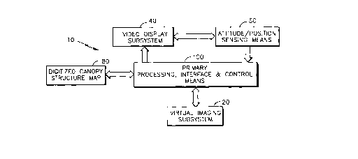
Figure 1 is a schematic diagram of a virtual
image display system incorporating structural
outlines according to the present invention.
Figure 2 is a plan view of a helicopter in
which the virtual image display system of the
present invention may be used.
Figure 3 is a plan view of a helmet mounted
display subsystem having utility in the virtual
image display system of the present invention.
Figures 4A, 4B illustrate a polar coordinate
system as a reference system for the virtual image
display system of the present invention.
Figure 5A is a rectilinear plot of the canopy
structure of the helicopter of Figure 2.
Figure 5B is a rectilinear plot illustrating a
digitized map representing the optically opaque
structural outlines corresponding to the canopy
structure of Figure 5A.
Figure 6 is a schematic view of a primary
processing, interface, and control means for the
virtual image display system of Figure 1.
Figure 7 is a plan view of optically opaque
structural outlines superimposed onto a video
display of a virtual image of the external world.
S-4503 - 15 -
Detailed De~cription of Preferred Embodiments
Referring now to the drawings where like
reference numerals identify corresponding or similar
elements throughout the several views, Figure 1 is a
diagrammatic illustration of a virtual image display
(VID) system 10 according to the present invention
for use in piloting aircraft, particularly
helicopters, during non-visual flight conditions
such as night and/or adverse weather flight
operations. The VID system 10 according to the
present invention includes a primary processing,
interface, and control means 100, a virtual imaging
subsystem 20, a digitized map 80 of the aircraft
canopy structure 60, a video display subsystem 40,
and a means 50 for sensing the attitude and position
of the video display subsystem 40 with respect to a
predetermined aircraft coordinate system.
The VID system 10 according to the present
invention is operative to provide continuous virtual
images of the external world, to generate continuous
video displays based upon these virtual images of
the external world, and to transmit such video
images to the pilot via the video display
subsystem 40 for use in piloting the aircraft during
non-visual flight conditions such as night and/or
adverse weather flight operations. The VID
system 10 is further operative to superimpose a
synchronized portion of the digitized map 80 of the
canopy structure 60 upon the video images such that
the pilot is provided with a cognitive video display
orientated with respect to the helicopter canopy
structure 60, thereby~allowing the pilot to
reference the video displays representative of the
S-4503 - 16 -
external world vis-a-vis corresponding aircraft
canopy structure 60.
As discussed hereinabove, a pilot either
consciously or subliminally references visual images
of the external world perceived by means of his
visual system with corresponding parts of the
aircraft canopy structure during visual flight
operations. This cognitive mec~;cm allows the
pilot to maintain spatial and situational awareness
of the external world vis-a-vis the aircraft. The
VID system 10 of the present invention is thus
operative to provide the pilot with a cockpit
referenced view of the external world during
non-visual flight conditions that is functionally
and structurally equivalent to the pilot's view of
the external world during visual flight conditions
such that the cognitive mechanism that operates
during visual flight conditions may be utilized by
the pilot during non-visual flight conditions to
maintain spatial and situational awareness of the
external world vis-a-vis the aircraft. The VID
system 10 of the present invention precludes pilot
disorientation during non-visual flight conditions,
especially during flight conditions wherein the
corresponding aircraft canopy structure 60 cannot be
perceived by the pilot using his visual system.
The VID system 10 of the present invention has
particular utility for use in helicopters during
non-visual flight conditions such as night and/or
adverse weather flight operations. One such
helicopter H is exemplarily illustrated in Figure 2,
which depicts the RAH~66 Comanche light helicopter.
The RAH-66 helicopter H includes a transparent nose
section NS that houses a gimballed virtual imaging
S-4503 - 17 -
subsystem 20 and a cockpit CP having a predetermined
canopy structure 60, as described in further detail
hereinbelow. While the VID system 10 of the present
invention is described hereinbelow in terms of the
structure and configuration of the RAH-66
helicopter, it is to be understood that the VID
system 10 of the present invention may be utilized
in other helicopters and/or aircraft for non-visual
flight operations.
The virtual imaging subsystem 20 is operative
to provide continuous virtual images of the external
world during non-visual flight conditions, i.e.,
those flight conditions wherein the pilot's visual
system is unable to comprehend the external world
with sufficient clarity to ensure safe and/or
efficient operation of the helicopter H, e.g.,
during night and/or adverse weather flight
operations. The term virtual images as used herein
defines a realistic, high-definition pictorial
representation of the external world that
corresponds in structural definition to the same
external world if viewed by the human visual system,
e.g., a tree or building is recognizable as a tree
or building.
The operating characteristics and capabilities
of virtual imaging subsystems 20 of the type having
utility in the VID system 10 of the present
invention are well known to those skilled in the
art. For example, to generate virtual images of the
external world during night flight operations, a
forward looking infrared (FLIR) imaging subsystem 20
is the preferred means~, based upon the state of
present day technology, of generating continuous,
high-definition virtual images of the external world
S-4503 - 18 -
during night flight operations. The FLIR imaging
subsystem 20 senses differences in thermal radiation
emitted by the various elements of the external
world within the field of view (FOV) of the FLIR
sensors and generates signals representative of
detected thermal radiation differences that are
subsequently processed (see disclosure hereinbelow
re the primary processing, interface, and control
means 100) to provide continuous, high-definition
virtual images of the external world within the FOV
of the FLIR imaging subsystem 20. The FLIR imaging
subsystem 20 may be selectively operated to generate
hot and cold thermally differentiated images as
black and white contrasts or vice versa, depending
upon such factors as flight conditions, mission
requirements, etc.
Other imaging systems such low-light television
systems, radar systems, or other sensors that are
capable of generating high-definition virtual images
of the external world may be utilized as the virtual
imaging subsystem 20 in the VID system 10 according
to the present invention. As discussed hereinbelow
in further detail, the virtual imaging subsystem 20
is slaved to the video image display subsystem 40
such that the FOV of the virtual imaging
subsystem 20 is movably gimballed within the
transparent nose structure NS of the helicopter H to
align the FOV of the FLIR subsystem 20 to coincide
with the optical axis of the visual system of the
pilot of the helicopter H.
The video image display subsystem 40 of the VID
system 10 is operative~to position video images of
the external world (derived from the virtual images
captured by the virtual imaging subsystem 20)
S-4503 - 19 -
centered with respect to the optical axis of the
visual system of the pilot, i.e., within the field
of view of the pilot. With reference to Figure 3,
the preferred video image display subsystem 40 is a
helmet mounted display (HMD) subsystem that includes
a helmet 42 and a visor type screen 44. The
screen 44 may be fabricated as a reflective part of
the optical train by utilizing a screen material
that is partially reflective so that the screen 44
is operative to focus and project collimated video
images onto the visual system of the pilot.
Concomitantly, the screen 44 may be fabricated to be
partially transparent to visible light radiation
from the external world. The screen 44 is thus
simultaneously operative to facilitate viewing of
the external world (and the canopy structure 60) via
the pilot's visual system during visual flight
conditions and to project collimated video images,
derived from virtual images provided by the virtual
imaging subsystem 20, onto the pilot's visual system
that provide a realistic, high-definition pictorial
representation of the external world during
non-visual flight conditions. The video images
viewed by the pilot appear to be located at infinity
due to the collimation of the video images.
The visor type screen 44 may be removably
attached to the helmet 42 so that the screen 44 may
be removed for visual flight operations if desired.
The screen 44 may be fabricated with a defined
curved configuration to provide a 30~ X 60~ degree
panoramic field of view of the external world to the
pilot (vertically and laterally, respectively, with
respect to the optical axis of the pilot's visual
system which is defined as a straight line
S-4503 - 20 -
projecting outwardly from the pilot's head from a
point midway between his eyes).
The HMD subsystem 40 may be binocular and may
include dual miniaturized cathode ray tubes
(CRTs) 46 such as those manufactured by Thomas
Electronics, Hughes Aircraft, or AT&T Bell
Laboratories, that receive image signals from the
primary processing, interface, and control means 100
and which are operative to generate high-definition
video images therefrom. A one-inch diameter CRT 46
may provide 1200 video lines, i.e., a 1200 X 1200
pixel matrix. Associated with each CRT 46 is a
collimating optical train 48 that provides the
optical interface between the CRTs 46 and the
screen 44 for the high-definition video images, the
optical train 48 being operative to magnify and
collimate the video images generated by the CRTs 46
for projection of video images onto the screen 44
for viewing by the pilot's visual system. The HMD
subsystem 40 may be operative to generate
overlapping video images such that the pilot
perceives a unitary, panoramic, high-definition
video pictorial representation of the external world
via the screen 44. HMD subsystems 40 having utility
in the VID system 10 of the present invention are
generally known to those skilled in the art. A
representative example of a HMD subsystem is
described in U.S. Patent No. Re 28,847.
Associated with the helmet 42 of the HMD
subsystem 40 is a sensing means 50 that is operative
to define the spatial position and angular
orientation of the HMD subsystem 40 within the
cockpit CP of the helicopter H. As exemplarily
illustrated in Figure 3, the helmet sensing means 50
S-4503 - 21 -
:-7 ~
comprises a sensor 52 mounted in combination with
the helmet 42 and an electromagnetic radiator 54
mounted in the cockpit CK adjacent the helmet 42.
The sensor 52 is responsive to constant field
strength electromagnetic radiation emitted by the
electromagnetic radiator 54 to generate
position/orientation signals, corresponding to the
position and angular orientation of the HMD
subsystem 40 in the cockpit CK, based upon the field
strength and phase of the intercepted
electromagnetic radiation. These
position/orientation signals are coupled to the
primary processing, interface, and control means 100
which is operative to process such signals to
identify the position and angular orientation
(perspective) of HMD subsystem 40 in relation to the
cockpit CK. Helmet sensing means 50 having utility
in the VID system 10 of the present invention are
generally known to those skilled in the art, such
sensing means ~eing exemplarily illustrated by the
three-axis Polhemus systems that provide signals
indicative of the angular orientation of the
helmet 42 in three axes as described in U.S. Patent
Nos. 4,017,858 and 3,983,474.
An imaginary reference point 90, designated as
the "design eyepoint", is defined in the cockpit CK
of the helicopter H as illustrated in Figure 2
(imaginary in sense that the design eyepoint 90 does
not coincide with any structural elements or
equipment comprising the canopy structure 60). The
design eyepoint 90 is a design parameter that
defines the degree of visibility (unimpaired visual
field of view of the external world) provided to the
pilot of the helicopter H based upon the structural
S-4503 - 22 -
configuration of the canopy structure 60. By way of
example, for military helicopters having a
single/tandem cockpit configuration, MIL-STD-850B
sets forth suggested visibility requirements for the
canopy structure.
For flight operations, the pilot positions
himself in the cockpit seat CS (see Figure 2) and
adjusts the cockpit seat CS so that the origin of
the optical axis of his visual system coincides with
the design eyepoint 90 as illustrated in Figure 3.
To facilitate this alignment process, the RAH-66
helicopter H includes a boresight reticle unit
mounted on the cockpit dashboard (coincident with
the medial plane of the cockpit) and positioned so
that, when activated, collimated light is emitted
that passes through the design eyepoint 90. Only
when the pilot is properly positioned in the
cockpit CP, i.e., the origin of the optical axis of
his visual system is coincident with the design
eyepoint 90, will this collimated light be
perceptible to the pilot's visual system.
The design eyepoint 90 defines an origin
(0, 0, 0) of a coordinate system for the VID
system 10 of the present invention. To facilitate
the identification and description of the spatial
location and perspective of the HMD subsystem 40 by
means of the primary processing, interface, and
control means 100, a polar coordinate system (r, e,
~, a), as exemplarily illustrated in the plan views
of Figures 4A, 4B, which are overlaid on the
corresponding cockpit configuration of the
helicopter H, is utili-zed to define the spatial
location and perspective of the HMD subsystem 40 and
to generate the digitized map 80 of the canopy
S-4503 - 23 -
~ , J
structure 60, as discussed in further detail
hereinbelow. Also illustrated in Figures 4A, 4B is
the three axes coordinate system generally used for
helicopter descriptive purposes, i.e., the
longitudinal axis X-X, the transverse axis Y-Y, and
the vertical axis Z-Z. As described hereinbelow in
further detail, the polar coordinate system may be
used to define any point (x, y, z) of the canopy
structure 60 by means of the transformation~0 equations:
x = r(cose)
y = r(cos~)
z = r(cos~)
r2 = x2 + y2 + z2
Identifying the spatial location and
perspective of the HMD subsystem 40 is generally
simplified by use of the polar coordinate system.
As a general rule, once a pilot is properly
positioned in the cockpit seat CS, as described
hereinabove, the majority of head movements (which
directly correspond to HMD subsystem 40 movements)
naturally made by the pilot during typical flight
operations consist of head rotations about the
vertical axis Z-Z (left-right head turning
movements), head rotations about the lateral
axis Y-Y (up-down head movements), or combinations
thereof. The foregoing head movements define the
spatial perspective of the HMD subsystem 40, i.e.,
the pointing angles of the optical axis of the
pilot's visual system (which may be defined by the
radius vector of the polar coordinate system), which
may be described in terms of the angle e, the
angle ~, or combinations thereof, respectively, of
the polar coordinate system.
S-4503 - 24 -
Experience has shown that there will be
relatively little translational movement of the
pilot's head along the longitudinal, lateral, and/or
vertical axes during normal flight operations.
Pragmatically, therefore, the HMD subsystem 40 may
be defined as having a constant spatial location
coincident with the origin of the polar coordinate
system. Even if the HMD subsystem 40 is subjected
to translational movements, such movements may be
~lO accommodated and identified utilizing the processing
capability of the primary processing, interface, and
control means 100 inasmuch as such movements involve
computations based upon relatively straightforward
geometric relationships.
The initialized spatial location and
perspective of the HMD subsystem 40 is defined in
terms of the design eyepoint 90 and the optical axis
of the pilot's visual system. The initialized
spatial location of the HMD subsystem 40 is defined
as the design eyepoint so, i.e., the origin of the
polar coordinate system. The initialized spatial
perspective of the HMD subsystem 40 is defined so
that the optical axis of the pilot's visual system
is coaxial with the longitudinal axis X-X passing
through the design eyepoint 90 and medially through
the forward portion of the cockpit CP canopy. The
helmet sensing means 50 is initialized to the
foregoing initialized spatial location and
perspective of the HMD subsystem 40. Subsequent
movements of the HMD subsystem 40 are detected by
the helmet sensing means 50, and defined and
described in terms of the direction angles e, ~ ( or
the radius vector r and the direction angle ~, as
required) utilizing the processing capability of the
S-4503 - 25 -
primary processing, interface, and control
means 100.
Figure 5A is a rectilinear plot of the canopy
structure 60 of the helicopter H illustrated in
Figure 2. The rectilinear plot was derived based
upon the design eyepoint 90 and the polar coordinate
system described hereinabove. The abscissa
represents the direction angle e and the ordinate
represents the direction angle ~. The canopy
structure 60 includes left and right windshield
posts 61L, 61R, a transverse post 62, left and right
forward sideposts 63L, 63R, left and right rear
sideposts 64L, 64R, left and right secondary
sideposts 65L, 65R, a forward cockpit rail 66, left
and right primary cockpit rails 67L, 67R, left and
right secondary cockpit rails 68L, 68R, and left and
right tertiary cockpit rails 69L, 69R.
The foregoing structural members comprising the
canopy structure 60 in respective combinations
define the viewing sectors of the canopy
structure 60 available to the pilot for visual
observation of the external world. These may be
defined as the forward canopy 70, the left and right
primary side canopies 72L, 72R, the left and right
secondary side canopies 74L, 74R, and the left and
right tertiary side canopies 76L, 76R as illustrated
in Figure 5A. The various canopies described above
are fabricated from an optically transparent
material such that visible light radiation from the
external world is transmitted therethrough to the
visual system of the pilot. The canopy members are
not relevant to the VID system 10 of the present
invention inasmuch as these members are effectively
transparent to the pilot's visual system, and as
S-4503 - 26 -
such, do not function as reference points for visual
observations of the external world by the pilot
during visual flight operations, and therefore, are
not part of the pilot's cognitive mechAn;sm for
maintaining spatial and situational awareness of the
external world vis-a-vis the helicopter H.
In contrast, the structural posts and rail
members of the canopy structure 60 occlude the
pilot's visual observation of the external world
during visual flight operations. As such, the
pilot, either consciously or subliminally,
references visual observations of the external world
to respective structural posts and rail members that
are interposed between the pilot and the external
world. The structural posts and rail members of the
canopy structure 60 as described hereinabove are an
integral element of the cognitive mechanism that
allows the pilot to maintain spatial and situational
awareness of the external world vis-a-vis the
helicopter H during visual flight operations.
Therefore, the VID system 10 of the present
invention incorporates these elements of the canopy
structure 60 into the virtual images that define the
realistic, high-definition pictorial representation
provided to the pilot during non-visual flight
operations (via the FLIR subsystem 20 and the HMD
subsystem 40) so that the pilot may rely upon and
utilize the same cognitive mech~nism that is
operative during visual flight operations during
non-visual flight operations to maintain spatial and
situational awareness of the external world
vis-a-vis the helicopter H.
Figure 5B is a to-scale rectilinear digitized
map 80 corresponding to the canopy structure 60
S-4503 - 27 -
$
illustrated in Figure 5B and described hereinabove.
The digitized map 80 is an interrelated series of
structural outlines that correspond to the
structural posts and rails of the canopy
structure 60 as described hereinabove. Structural
outlines 81L, 81R correspond to the left and right
windshield posts 61L, 61R, respectively, structural
outline 82 corresponds to the transverse post 62,
structural outlines 83L, 83R correspond to the left
and right forward sideposts 63L, 63R, respectively,
structural outlines 84L, 84R correspond to the left
and right rear sideposts 64L, 64R, respectively,
structural outlines 85L, 85R correspond to the left
and right secondary sideposts 65L, 65R,
respectively, structural outline 86 corresponds to
the forward cockpit rail 66, structural
outlines 87L, 87R correspond to the left and right
primary cockpit rails 67L, 67R, respectively,
structural outlines 88L, 88R correspond to the left
and right secondary cockpit rails 68L, 68R,
respectively, and structural outlines 89L, 89R
correspond to the left and right tertiary cockpit
rails 69L, 69R.
The digitized map 80 may be formed by utilizing
the polar coordinate system described hereinabove to
define digitized structural outline sequences (based
upon digital points defined and identified by the
polar coordinate system) corresponding to each of
the posts and rails comprising the canopy
structure 60. The map 80 is assembled in digitized
form to facilitate storage of the map 80 in a memory
structure in the prim~ry processing, interface, and
control means 100. During reconstruction of the
relevant structural outlines of the digitized map 80
S-4503 - 28 -
by the primary processing, interface, and control
means 100 for subsequent superimpositioning onto
corresponding video images, the primary processing,
interface, and control means 100 is operative to
interpolate between adjacent digital points defining
the respective structural outlines so that the
reconstructed structural outlines are provided as
continuous structures. The primary processing,
interface, and control means 100 may be further
operative to vary the thickness of the structural
outlines, as required.
The primary processing, interface, and control
(PPIC) means 100 of the VID system 10 is exemplarily
illustrated in further detail in Figure 6. The PPIC
means 100 exemplarily illustrated includes a central
processing unit 102, a random access memory
(RAM) 103, a read only memory (ROM) 104,
input/output ports 106, 108, 110, 112, and a
control, address, data bus 114. The PPIC means 100
is illustrated in generalized form as a general
purpose computer that may take on forms different
than that specifically illustrated.
The computer architecture may be of the split
processor type having more than one control,
address, data bus. One bus may be dedicated to
input/output tasks and communication functions.
Another separate bus may be dedicated to image
processing, definition functions, and map line
reconstruction and conversion to video format. For
architecture employing more than a single bus, each
bus would typically have a processor such as a
Motorola 80286 type processor associated therewith.
The PPIC means 100 may be implemented in the form of
Very High-Speed Integrated Circuitry (VHSIC) with
S-4503 - 29 -
1.25 microns between geometric features. Such a
PPIC means 100 may have more than 13 megabytes of
internal memory, and the capability of executing 19
million instructions per second and 300+ million
operations per second.
The PPIC means 100 is operative to provide
electronic interfacing among the various subsystems
comprising the VID system 10 as described
hereinabove, via signal lines 116, 118, 120, 122,
124, respectively. Interactive coupling between the
HMD subsystem 40 and the helmet sensing means 50 is
identified by reference numeral 130.
The PPIC means 100 is operative to provide
control signals via signal line 116 to synchronize
the spatial orientation of the virtual imaging
subsystem 20 with the perspective of the HMD
subsystem 40, i.e., to align the FOV of the virtual
imaging subsystem 20 in correspondence to the
optical axis of the pilot's visual system. These
control signals are derived by central processing
unit 102 based upon the position/orientation signals
provided by the helmet sensing means 50 via signal
line 122.
The PPIC means 100 is further operative to
provide the necessary processing capability required
by the VID system 10 of the present invention. This
processing capability includes processing the
virtual image signals generated by the virtual
imaging subsystem 20 and inputted via signal
line 188 to provide corresponding signals to the HMD
subsystem 40, via signal line 120, for generation of
video images correspo~ding to the virtual image.
The PPIC means 100 is also operative to define the
spatial orientation and perspective of the HMD
S-4503 - 30 -
'q ~
subsystem 40 based upon position/orientation signals
provided by the helmet sensing means 50 via signal
line 122.
The PPIC means 100 is also operative to
correlate the defined spatial orientation and
perspective of the HMD subsystem 40 to the canopy
structure 60 of the helicopter H by means of the
central processing unit 102. Based upon the
correlated spatial orientation and perspective of
the HMD subsystem 20, the central processing
unit 102 reconstructs structural outlines of the
relevant portion(s) of the canopy structure 60,
utilizing the digitized map 80, to provide
structural outlines that are synchronized with the
virtual images generated by the virtual imaging
subsystem 20. The central processing unit 102 may
be utilized to convert the synchronized structural
outlines to a video format that is compatible with
the video image generated by the HMD subsystem.
The PPIC means 100 is further operative to
combine the synchronized structural outlines onto
corresponding video images in a predetermined manner
via signal line 120. More specifically, the
synchronized structural outlines are superimposed
onto corresponding video images such that the
structural outlines occlude corresponding portions
of the underlying video image. However, due to the
configuration (thickness) of the structural
outlines, occlusion of the video images is
minimized.
Figure 7 is a pictorial representation of an
instantaneous combined video image generated by
means of the VID system 10 of the present invention.
This pictorial representation is viewed by the pilot
S-4503 - 31 -
by means of the HMD subsystem 40 and utilized by the
pilot to maintain spatial and situational awareness
of the external world vis-a-vis the helicopter H
based upon the cognitive mech~n;cm described
hereinabove. The pictorial representation of
Figure 7 illustrates structural outlines 81L, 81R,
corresponding to the left and right w;n~h;eld
posts 61L, 61R of the helicopter H, superimposed
upon a video image generated by the HMD subsystem 40
which was derived from a virtual image provided by
the virtual imaging subsystem 20. The video image
displays elements of the external world such as a
helicopter He in flight, trees T, and a building B
that are within the FOV of the virtual imaging
subsystem 20. Other symbology illustrated in
Figure 7 is representative of aircraft status
information that is not pertinent to the present
invention. The symbol identified by the reference
letters AHL is an artificial horizon line
corresponding to the horizon line of the external
world.
With respect to Figure 7, the structural
outlines 81L, 81R apprise the pilot that the
displayed pictorial representation is being viewed
through the forward canopy 70 of the helicopter H.
Correlating the structural outlines 81L, 81R with
the artificial horizon line AHL apprises the pilot
that the helicopter H is being flown in a shallow
bank to the left. This information provides the
pilot with spatial awareness of the relationship
between the helicopter H and the external world
utilizing the cognitive mech~nism described
hereinabove.
S-4503 - 32 -
Correlating the structural outlines 81L, 81R
with the pictorial display of the helicopter He
apprises the pilot that the helicopter He may be on
a flight path that will intersect the pilot's
course. The trees T and building B apprise the
pilot of the proximity of the helicopter H that may
present hazards to forward flight. This information
provides the pilot with situational awareness of the
relationship between the helicopter H and the
external world utilizing the cognitive mechanism.
A variety of modifications and variations of
the present invention are possible in light of the
above teachings. It is therefore to be understood
that, within the scope of the appended claims, the
present invention may be practiced otherwise than as
specifically described hereinabove.
S-4503 - 33 -