Note: Descriptions are shown in the official language in which they were submitted.
WO 9i/06878 ~ ~ ~ ~ ~ ~ ~ PCT/N090/OOi58
1
SEISMIC DEVICE
TECHNICAL FIELD
The present invention relates to a device and a method for
execution of marine explorations of the kind which are
indicated in the preambles of the main claims. Basically,
the invention concerns seismic exploration of the substratum
offshore where pressure and shear waves from the substratum
are measured in response to 'the releasing of pressure and/or
shear wave energy.
BACKGROUND ART
Marine seismic exploration are usually carried out by a
seismic cable provided with several hydrophones being towed
at a certain depth. Pressure waves are released in the
vicinity of the cable in several ways. This usually takes
place by means of air guns. The pressure wave energy travels
downwards through the substratum, but parts of the pressure
waves are reflected from areas where there are acoustic
impedance features in the substratum. The hydrophones record
the reflected pressure waves in the water and transform this
information into electric signals which are received and
processed on the seismic ship which tows the cable. Using
this method only reflected and/or converted shear to
pressure wave energy is recorded. However, it is known that
down in the formation both pressure waves and shear waves
. will be reflected. The shear waves do not travel in water
and cannot therefore be detected by a hydrophone cable.
Moreover, with today's conventional hydrophone technology,
it is not gossible to detect the directions of the measured
signals, and this severely complicates possibilities for
three-dimensional data collection.
WO 91/0687 PCT/N~90/0015'
2
DISCLOSURE OF INVENTION
The objective of the invention is to provide a new and
improved device and method for the recording of three-
s dimensional pressure and shear waves which travel in the
substratum.
The new distinctive features of the invention are disclosed
in the characterizing part of the two main claims. Further
advantageous features are disclosed in the dependent claims.
BRIEF DESCRIPTION OF DRAWINGS
The invention will be more closely described in the
following, with reference to the accompanying drawings
where:
25
Fig. 1 shows a schematical drawing of a geopole according to
the invention.
Fig. 2a illustrates a sub sea vessel after the laying out of
poles on the sea-bed, seen from above.
Fig. 2b illustrates execution of a seismic exploration.
Fig. 2c illustrates a magazine for poles according to the
invention.
MODES FOR CARRYING OUT TOTE INVENTION
The device shown in fig. 1 has a pole-like shape and
comprises a cylindrical portion 1, a lower sonically shaped
or pointed end 2 and an upper portion 3. The upper portion 3
is compatible to eguipment for inserting the pole down into,
or pulling it out of the sea bed. In the shown embodiment,
the upper portion is designed with a narrowing part ~ and an
upper flange 5. This design is advantageous in that the
WO 91/06878 ~ ~ ~ ~ ~ ~ ~ PCT/N090/00158
3
flange 5 can be utilized as a striking organ for forcing the
pole down into the sea bed. The narrow part 4 is useful for
instance when an engaging organ on a submarine is to pull up
the pole from the sea bed, by making contact with the
underside of the flange.
The pointed end 2 of the pole is insulated from the rest of
the pole by a vibration insulating spacer 6. In a preferred
embodiment the spacer 6 is made of an elastomer.
The actual point is shown in fig. 1 with a substantially
conical shape which makes it easier for the pole to
penetrate down into the sea bed. Other forms of embodiment
are also applicable, for example a point divided into two
with a lower cone shape ending in a shoulder and thereafter
progressing into a new cone portion. Within the scope of the
invention, other embodiments of the point can also be
conceived.
The cylindrical part 1 of the pole constitutes the main
volume of the pole and comprise:. a substantial part of all
the equipment. The actual pole ahould be made of a metal,
suitable an aluminium alloy.
2~5 The pointed end of the pole comprises, in a preferred
embodiment, three geophones 7-9 arranged three-dimensionally
in an x, y and z direction. The geophones 7-9 which as such
are of a known type per se being commercially available, and
will therefore not be more closely described. It is
important that the geophones 7°9 are given good contact with
the pointed end 2 of the geopole and this can be achieved by
the geophones being moulded into the pointed end by means of
a polymer material.
In the pointed end 2 an electronic angle gauge 10 is also
placed, which, based on the force of gravity forms the angle
of the pole with the vertical axis. The end comprises
W~ 91/06878 PCT/N0901001~
4
further a compass 11 by which the rotation of the pole in
the plane can be read. By means of these instruments, the
exact position of the pole can be decided, which is
necessary in order to decide the direction of the measured
signals.
The cylindrical portion 1 of the pole contains 'the other
equipment components. The location of the various components
is decided by several factors. An important factor is that
the pole's centre of gravity shall be as close as possible
to the pointed end 2. It is also desirable that components
which are in direct contact with each other are also
localized next to each other.
In the shown embodiment, a battery 11 which can provide
power to the other systems is placed at the lowermost part
of the cylindrical portion. Rechargeable lithium batteries
are the preferable choiceo Suitably the batteries will be
recharged above the sea. If recharging should take place
under the water, dependence on conductive couplings should
be avoided in stead, recharging should take place by
induction in a coil which is placed in the cylinder wall or
is fitted into the engagement flange 5.
Above the battery, in the next unit, a processor 12 is
placed, which at least processes signals from the geophones
?-9, from the electronic angle gauge l0a/the compass lOb and
from a hydrophone which will be more closely described
later.
In a next unit placed above the processor 12 a memory unit
13 is placed. Seismic data, as well as background
information about angle and direction is stored partly in
the processor 12 and partly in the memory part 13.
The pole comprises further a power supply unit 1g for supply
of power to the various units.
W~ 91/06878 ~ ~ '~ ~ ~ ~ ~ PCT/1V~90/00158
The pole comprises further an acoustic communications system
which can fulfil several functions. When several poles
stand together in a pattern on the sea bed, it is necessary
that it is possible to start/stop the collection of data of
5 all of the poles at the same time. This can be done via
acoustic signals which are detected by the geopole's
receiver. Moreover it will be desirable that the poles are
able to transmit acoustic signals when the poles are
gathered in again. The acoustic communications system 15 can
10 handle small amounts of data and can communicate across
larger distances.
Further, the pole comprises an optical or magnetic reader 16
which makes possible rapid reading of the results of the
15 seismic collections. Read-off will, in the embodiment which
is shown in fig. 1, be able to take place after the poles
are gathered in again.
The uppermost unit in the pole comprises a hydrophone 17
which is a transducer for pressure waves. Pressure and shear
waves (P and S waves) which are reflected from the
sediments, are detected by the three-dimensional geophones
placed in the lower pointed end 2 of the geopole, while the
hydrophone 17 only detects pressure waves in the water
layer. When measurements from the hydrophone and from the 3
geophones 7-9 are correlated, and taking into consideration
the distance between the hydrophone 17 and geophones 7-9. it
is possible to separate upwardly travelling, reflected P°
waves and S-waves from the P-waves which are reflected from
the sea surface.
Without it in any way being considered to limit the
invention, typical dimensions for a pole could be a length
of approximately 1 m and a diameter of approximately 10 cm.
The pole, when in use, shall be forced well down into the
sea bed so that the pointed end 2 provides good contact with
the sea bed. With the dimensions of the geopole which axe
2~°~2~98
w~ ~no6s~s Pcr«~9oiooisP
6
mentioned above, it will, typically, be forced approximately
20-40 cm down into the sea bed. The depth is moreover
strongly dependent on the nature of the sea bed. Soft bed
requires deeper penetration and vice versa.
In the following, a preferred method for utilization of
several geopoles in seismic exploration of off-shore
substratum will be described with reference to Fig. 2a-2c.
In a preferred embodiment the poles, as shown in Fig. 2a,
will prior to the exploration be inserted into the sea bed
in a definite pattern. In Fig. 2a an example is shown of
such a pattern where the poles 21 are placed in the corners
in a quadratic square pattern. A regular and rectangular
15 square pattern can also be possible and is dependent on the
purpose of the survey.
In laying-out of two-dimensional geopole arrays on the sea
bed, it is possible to achieve three-dimensional data
20 collection which is important in order to make true three-
dimensional depiction of the substratum possible.
In some situations it will be advantageous to have the
geophones 21 placed in groups, so that the mutual distance
between the poles 21 varies for each group. This will be
particularly advantageous when it is desirable to specially
survey local parts of the substratum.
The laying out of the geopoles is a time-demanding and
somewhat difficult operation, not least because it is
desirable that the poles are set out in a fairly accurate
position. In Fig. 2a-2b it is indicated that the laying-out
can be carried out be means of a submarine vessel 22. The
poles can be stored in a magazine 23 in the submarine vessel
22. The magazine is shown in larger scale in Fig. 2c, and as
the submarine vessel 22 moves along a line, poles are forced
one by one into the sea bed.
V1~0 91 /06878 PCT/N090/00158
7
After the poles 21 are placed out in the desired pattern,
the seismic exploration can start by means of a seismic ship
in the form of a submarine vessel 22 as shown in Fig. 2a-2b
or a surface vessel.
The seismic ship will be provided with a source for
generating wave and shear energy down in the formation in
the vicinity of the poles 21. The energy source can come
from many generators known per se. An air cannon which is
the most usual source in marine surface seismology is
suitable, even although it generates "'secondary sources"
(bubble effects) which will increase with increasing sea
depth. Explosive sources are another well tried energy
source which gives very good results. The explosives can be
laved out on the sea bed or drilled a few metres down into
the formation.
When using an underwater vessel 21, a marine bed vibrator 24
will be particularly advantageous. A modified version of
existing vibrators can be used, in that it is pushed or is
sucked towards the sea bed and functions as land seismic
vibrators in operations.
The advantage of placing a vibrator on the sea bed is that
it then becomes possible to snake a greater part of the
energy penetrate down into the sea bed and moreover achieve
control and flexibility of the transmitted source
signatures.
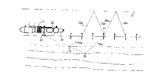
In the following a seismic exploration according to the
invention will be described more closely.
A pressure, or combined pressure and shear wave is generated
from a source and travels from the sea bed 20 and down into
the substratum. In areas where there is a division in
acoustic impedance between the layers in the formation, for
example.the points 25 and 26, a part of 'the energy will be
WO 91/06878 PCT/1~1~90/001~~
8
reflected upwards as a combination of shear and pressure
waves. They are indicated in Fig. 2 as wave 25a, 26a from
the points 25 and 26 and the waves are recorded by the
poles' geophones and hydrophones. The shear waves do not
'travel in water and they will transform into pressure waves
at the sea bed 20 and travel further upwards illustrated in
Fig. 2b as the waves 25b, 26b which will reach 'the water
surface 27 where a part of them will be reflected back
towards the sea bed as the waves 25c, 26c. The objective of
the poles' hydrophones together with the geophones is
exactly to be able to record downwardly travelling
reflection waves from the surface together with the upwardly
travelling reflection waves on the sea bed. Since geophones
and hydrophones have a known orientation and distance of
depth between each other, it is possible to separate
upwardly and downwardly travelling waves.
Such a separation will be necessary because multiples or
reflections from the sea surface will arrive at various
points of time and will dominate the measurements more than
in conventional collection.
After the seismic ship has generated the wave energy from
one position, the ship changes position and generates new
wave energy. Z'he changing o~ position o~ the seismic ship
each time wave energy is generated will take place in a
predetermined pattern.