Note: Descriptions are shown in the official language in which they were submitted.
Wo 95/29538 P~~ C ~ :3
21 ~8254
COST 15~ rlV~: GEO~ US MOBILE SATEI,LITE
COMMUNICATION SYSTEM
s BACRGROUND OF TE~E INvENTIoN:
Enormous activity has taken place, and resources expended in
" recent years towards defining a broad range of future satellite
communication (satcom) system architectures that are striving to
provide global services. These services ar, - 'Ate both
stationary and mobile users, and range in sophistication from
one-way paging and messaging to two-way high-quality voice.
During recent years, activities have also included many filings
with the FCC in order to receive approval to proceed with
development, launch, and operations by the mid-to-late 1990's.
the concepts proposed have been quite diverse and encompass:
1. Low Earth Orbits (LEO) -- e.g., Motorola's Iridium,
Loral's Globalstar, and Orbital Sciences Orbcomm -- which propose
operational constellations with satellite quantities ranging from
26 to 66.
2. Medium Earth Orbits -- e.g., TRW's Odyssey -- which
propose operational constellations with satellite quantities on
the order of 12.
3. Geosynchronous Orbits (GEO) -- e.g, American Mobile
Satellite in geostationary orbit -- which either provide regional
coverage, or would require on the order of 4 to 5 satellites for
global coverage at latitudes up to 70.
Many tradeoffs have been addressed in the literature
describing these systems. Examples include:
Benefits of decreasinq orbital altitude:
1. Per satellite launch cost decreases.
2. User and satellite transmit power and/or antenna
complexity decrease.
3. Propagation delay decreases.
~3enefits of increasinq orbital altitude:
1. Quantity of operational satellites and supporting ground
stations decrease.
WO gi/29538 PCrlllS95/04949
2 ~ 5 ~ ~
2 . Satellite handover complexity ~ decreases, and i9
eliminated in the GEO architecture.
3. For the GEO architecture, full operational capability can
evolve -- one geographic region at a time -- per launch.
4. Satellite life increases or altitudes above the Van .
Allen Belts.
Other considerations:
1. A non-stationary satellite system is more amenable to
providing attractive user-to-satellite elevation angles.
2. The quantity of operational satellites is heavily driven
by truly global coveEage (100% of the time) vs. alternatives
(e.g., only land masses or less than 10096 at extreme latitudes),
and the minimum acceptable user-to-satellite elevational angle.
Ultimately, the drivers for a successful commercial system
must reduce to the combination of cost, service and quality
benefits, and rr~liAhility. While many detailed as~sumptions enter
into cost calculations, Fig. 1 presents the results of cost
trades analysis (done by others), for a specific mobile satcom
system application supporting two-way voice, that r,nl ~5
satellite complexity, launch cost and satellite quantity. These
results demonstrate the cost effectiveness of Odyssey MEO system.
At the same time, however, these results provide the key message
that GEO system cost is not much greater -- even though the
individual GEO satellite cost may be high -- given its much
smaller constellation size, fewer ground stations, simpler
control, and the longer lifetime of each satellite.
The insight gained from the analysis shown in Fig. 1 are
actually much more profound since they provide a much broader ~nd
exciting message concerning GEO systems:
If sufficient implementation tweight, size, power,
complexity) and launch cost reduction per GEO satellite can be
achieved, while simultaneously enhancing coverage and
satellite/user elevation angles, then a GEO constellation
potentially emerges as the lowest cost alternative for providing
global, mobile satellite communications. In addition, th~ GEO
Wo 9s~9538 F~~ r.'O Is :5
~ 21 8~4
cost benefit can be maximized by targeting a carefully selected
set of mobile and non-mobile applications that are ideally suited
for GEO satellites.
The ob~ect of this invention is to provide an improved
satellite communication system using geosynchronous.
SUNMARY OF TE~E INVENTION:
The GEosynchronous Mobile Satcom (GEMS ) system of this
invention (hereafter sometimes referred to as GEMS) an entirely
new satellite constellation and satellite architecture to cost-
effectively and efficiently service a large, diverse population
of mobile and non-mobile users. The GEMS concept emphasizes
high-capacity, low-power, random access transmissions from ground
users to the satellite, with a more limited capacity for
transmissions to the ground user. Representative applications
include: search and rescue; automated meter reading via
transmission to satellite; tracking of truck fleets, boats,
tankers via periodic transmissions to satellite; two-way
CommUniCations when a user is in a remote area ( e . g ., augments
terrestrial col l~ r network) (see Fig. 2) .
The novel satellite constellation and satellite design
simultaneously combine the benefits of geosynchronous satellites
and LEO/MEO satellites. Unique satellite system features claimed
are:
1. Constellation of geosynchronous satellites, inclined @
28.5. While an inclination of ~ 0 represents the conventional
approach of geosynchronous satellites, and is attractive for
precise regional coverage, the higher, proposed inclination
provides unique advantages, not achievable via O inclinations:
a. 5 to 6 satellites provide continuous global coverage,
with high elevation angles (e.g., > 25 - 30) over
virtually all land masses with significant population
densities. Such elevation angles are important for
reliable satellite communications in areas containing
structures, such as buildings.
Wo9~/29~38 2 ~ ~254 P~
.
b. For this same satellite constellation, elevation angles
also exceed 15 - 20 in most other global areas,
including oceans and polar areas, with every point on
earth being provided a continuous elevation angle >
10. Note that lower elevatlon angles are permissible
in such "open~ areas that do not densely contain
structures .
c. The 28.5 inclination provides a minimum energy launch,
f rom the key launch site of Cape Kennedy, thereby
reducing launch cost and/or yielding increased on-orbit
fuel for increased spacecraft life.
d. The GEMS satellite motion provides the ground user with
a signal source for position determination purposes.
This can augment GPS for increased accuracy and/or
increased robustness via one or more of the following
approaches: apply the GEMS as a ranging/doppler source;
apply each GEMS satellite as a reference for
Dif ferential GPS ( DGPS ); take advantage of the ~ 1 G~lz
frequency separation between GPS and GEMS to obtain
highly accurate ionospheric corrections ~ this may be
especially valuable for high-accuracy applications,
such as surveying ) .
2. The geosynchronous satellite constellation of this
invention is a significant departure from the LEO and MEO mobile
satcom concepts that are belng proposed, and offers significant,
unique advantages:
a. Dramatic reduction in the required number of satellites
-- e.g., 5 to 6, as compared to 66 for Motorola's
Iridium .
b. Much simpler operations. In particular, the ground
user virtually never has to hand-over from one
satellite to another during a service period. In
addition, the "slower ' relative motion of the satellite
reduces signal dynamics, thereby simplifying and
WO 95/29538 ~ 1 8 ~ 2 5 ~ C :~4~
.
speeding up the user signal acquisition process.
c. The higher, geosynchronous orbit leads to reduced drag
and less radiation effects, thereby leading to
increased spacecraft life and reduced replPni Rl t
requirements, and hence, reduced life cycle cost. The
simple nature of the satellite design (described below)
also leads to operational robustness and increased
life. A spacecraft life of at least 15 years is
anticipated .
d. No more than 3-4 ground stationb are required to
provide global/space ground connectivity for continuous
TT&C .
e. The geosynchronous constellation/capability can evolve
one global region at a time, without service gaps.
This is in dramatic contrast to a LEO or MEO
constellation .
3. The satellite design uniquely applies phased array
antenna technology in a manner that has not been proposed to date
for any commercial satellite system. This design effectively
Rates for the higher path 10s5 of geosynchronous
satellites, without - i Ring on continuous global coverage.
In other words, the geosynchronous satellite provides link
quality comparable to a LEO or MEO. In addition, the phased
array design provides a unique measure of operational and long-
life robustne88. Specific, unique features the user-to-satellite
(inbound) link are as follows:
a. High-capacity random access communications is
achievable via the combined use of Code Division
Nultiple Access (CDMA) and ground-based beamforming. A
user transmit data rate ~ 4 . 8 kbps is achievable with
<1 watt of transmit power into a near-omni
(hemispherical) antenna. It is believed that each GEMS
satellLte incorporating the invention can accommodate
more than 3000 simultaneous user transmissions.
W095/29538 21 ~8~4 E~llu~ -015;3
b. The large phased array simultaneously provides earth
coverage, spatial discrimination among geographically
distributed users, and very high gain. The earth
coverage is provided by each of the phased array
antenna elements, while each of the spot beams formed
on the ground provides the combination of spatial
discrimination and high gain. This capability is a
dramatic departure f rom conventional satellites,
because broad coverage and high gain are mutually
exclusive, unless complex/heavy/costly multi-spot-beam
capability is incorporated directly onto the satellite.
In the present invention, the broad beam coverage is
accomplished on the satellite via a straightforward
array of passive antenna elements, with the satellite
operating ln a " bent-pipe ~ mode -- L . e ., no on-board
processing is required. The more complex spotbeam
tArAhility is implemented on the ground, thereby
reducing complexity, risk and cost.
c. The ground-beamforming approach of this ~invention
of fers unique operational f 1 t~, i hi 1 i ty, evolution
, ArAhi 1 ity, and robustness since the satellite is
passive and all processing complexity is ground-based.
Specifically, the following may be accomplished on the
ground totally transparent to the satellite: vary the
number of beams; vary the size and shape of each beam;
perform open-loop or adaptive beamforming; a~ Ate
any on-board antenna element failures by ad~ustments in
the ground beamforming algorithm. In addition, the
ground beamforming hardware and software can evolve
over time (e.g.r as technology progresses), without
impacting the satellite, thereby offering the potential
for extended spacecraft life with evolutionary,
improving capability.
d. ~he on-board phased array uniquely provides the
satellite communication system of this invention with
WO95J29i38 r~ 49
~1 8~25~
significant robustness, since the satellite performance
gracefully degrades as antenna elements fail. In other
words, the loss of one or a few elements, out of 60-80
elements, introduces only a fraction of a d~
degradation in link performance. In addition, as noted
above, such element failures can, at least partially,
be accommodated by ad justments in the ground
beamf orming algorithm .
e. The space/ground link (SGL) antenna is the only moving
part in the communication payload, and moves
infrequently and slowly. This ensures simplified
attitude control, and further reduces on-orbit fuel
consumption .
f. The SGL downlink employs Ka-band, which provides an
allocated bandwidth on the order of 1 GHz. This is
adequate to arc ~Ate the individual downlink
trAn-mi ~sions, required from the 64-80 on-board
elements, for ground beamforming.
4. The satellite phased array of this invention also
provides unique capabilities on the satellite-to-user (outbound)
link. Specific features include:
a. One or more simultaneous beams may be formed. The
beamforming is accomplished via the setting of on-board
phase shifters, via ground command; no satellite motion
occurs . Total operational f lexibility exists in the
number and sizes of the formed beams. The specific
beam parameters vary vs. time as a function of time of
day, location of users, capacity requirements, data
rate and throughput requirements, priorities ( e . g .,
emergencies ), etc .
b. The beamforming flexibility enables satellite
conf igurations that support a broad range of data rates
(e.g., from < 1 kbps to ~ 100 kbps). At the lower data
rates the potential exists for accommodating several
hundred transmissions to users simultaneously). This
Wo gsl29538 P~ .,''C IS4~
~8~5~ ~
dynamic, variable spot beam capability is, again, a
capability not available on existing commercial
satellites.
c. Because the satellite serves as a bent-pipe, the
modulation~signal structure is not constrained, and can .
vary over the spa~ecraft life. The possibilities range
from narrowband F~equency Division Multiple Access
(FDMA), to wider band TDMA and CDMA.
d. As with the inbound case, above, the outbound
rArAhi 1 i ty can evolve over time via ground upgrades
only -- no satellite modifications are required. This
leads to unique operational flexibility, robustness,
and life-cycle-cost effectiveness not available via
other commercial satellite system concepts.
D~SCRIPTION OF TI~E: nRPWTN~
The above and other ob ~ects, advantages and features of the
invention will become more apparent when considered with the
following specification and ~ccompanying drawings wherein:
FIG. 1 is a graph illustrating cost trades, performed by TRW
Corp., among systems that employ satellites in low, medium, and
conventional geostationary orbits,
FIG. 2 illustrates the broad range of representative
services that may be provided by the satellite system of this
invention,
FIG. 3 illustrates the global satellite system architecture,
that requires only a relatively small number of satellites and
ground stations, and also optionally takes advantage of the GPS
constellation for user and satellite tracking,
FIG. 4 and FIG. 5 describe ground traces of the proposed
geosynchronous-inclined satellite system for the two cases of 5
and 6 satellite constellations, respectively,
FIG. 6 and FIG. 7 illustrate the minimum satellite-to-ground
elevation angles achievable via the 5 and 6 satellite
constellations, respectively, with orbital parameters arranged to
W0 95l29538 l ~ 'O :94~
~8~
emphasize land mass coverage,
FIG. 8 provides additional information for the 6 satellite
constellation, by illustrating the extremely attractive
satellite-to-ground elevation angles achievable at ma jor city
locations,
FIG. 9 is a pictorial illustration of the low-complexity
satellite, which includes a large, stationary phased array, and a
space/ground link antenna that is the only movable part of the
communication payload,
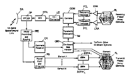
FIG. 10 illustrates a functional block diagram of the
satellite communication payload incorporating the invention, and
FIG. 11 illustrates a functional block diagram of each
ground terminal incorporating the invention.
nETATT.Er~ DESCRIPTION OF THE INYENTION:
The present invention introduces two unique system features:
1. Constellation of geosynchronous, inclined satellites
a. Satellite motion provides global coverage and enhances
user/satellite elevation angles.
b. 28.5 inclination minimizes GEO launch energy from U.S.
Cape Kennedy site.
c. Inclined GEO satellites simplify orbital slot
assignments relative to their geostationary
counterparts .
d. Tn~l in~fl GEO satellites reduce eclipse impact on on-
board power systems, relative to their geostationary
counterparts - reduced battery capacity.
2. The two-way mobile-user/satellite link is supported by a
large, passive phased array on each satellite.
a. The phased array simultaneously provides global
coverage and high gain, thereby keeping user
transmitter/receiver requirements comparable to those
of LEO or MEO system.
b. No steerable antenna, other than for the space/ground
link with the gateway; eases altitude control and
momentum dumping, and reduces fuel consumption.
wo 9~129538 PCrlUS951~4949
2~ ~825~ ~
c. Electronic ~teering of phased array accommodates
satellite motion and diverse satellite locations.
Electronic beam steering, in the case of the receiving
antenna, requires that signals from a number of
aeparate antenna elements, most commonly arranged in a -
planar area, be phase shifted by amounts riPr~On~iin~ on
the distance of the element from the center of the
array and the direction in which the beam is to form.
d. Beamforming on the user-to-gateway link is accomplished
on the ground, thereby dramatically reducing satellite
power/complexity/cost and greatly increasing
operational/evolutionary flexibility.
e. Dynamic allocation/ad~ustment of beamforming ri~r~hi 1 i ty
is based on need (e.g., emergency) or partial failures,
without impact on the attitude control system.
Especially significant is the tailoring of each GEO
satellite's phased array to the accommodation of dynamically
varying services based on coverage region, time-of-day, and need.
As shown in Fig. 2, representative services include:
1. Low-rate, spread-spectrum code division multiple access
(SS-CDMA) random access user tr,sn~mi ~sions (e.g., for reading of
electric/gas/water meters at homes, businesses, farms, etc. ) .
Interrogations occur only by exception, thereby minimizing
satellite transmitter requirements.
2. Low-rate random access transmissions from other user
types ( e . g ., globally distributed science sensors,
emergency/search-and-rescue transmitters, animal tracking
devices, etc. ) . Transmissions back to the user need not occur,
or occur as needed, again minimizing satellite transmitter
requirements .
3. Two-way data communications, which includes mix of data
rates ranging up to 4 . 8 kbps .
4. Two-way, 4.8 kbps voice.
5. Reference for differential GPS (DGPS) geolocation --
which would be capable of providing positionin~ accuracies to the
':
Wo gs/~9s38 r~ o
~ 382~4
11
several meter level.
These unique features, which are discussed in detail
hereinafter, ~JV'~ virtually all concerns associated with GE0
satellites, and in fact, lead to an operational system that is
ideally suited for utilization of GE0 satellites. As such, the
above features lead to a global satcom system that is more cost-
effective than any other ME0 or LE0 system proposed to date. In
addition, the satellite technology implementation risk is low,
given that the required subsystems have already either f lown, or
reflect mature technology. An example is NASA's Tracking and
Data Relay Satellite System (TDRSS ), whose satellites contain on-
board phased array antennas.
SYSTEM An~ n~;:
Fig. 3 illustrates a re~resentative global satellite system
architecture, that incorporates both the GE0 satellites of
interest, and assumes the availability of GPS signals to users
that require periodic updates of their position. It should be
emphasi~ed at the outset that the three GE0 satellites 10, 11 and
12 shown are illustrative only, with the specific required number
of satellites ultimately a function of system-level requirements.
In particular, the quantity and mutual phasing of satellites
within the constellation may be tailored to specific drivers.
These include:
1. Region-to-global coverage.
2 . Minimum elevation angles vs . ~eographic region ( e . g .,
latitude, rural vs. urban, or population density).
3. PrLmary and backup coverage over mid-latitudes.
4. "High" elevation angles in urban and high population
density areas.
5. "Lower" elevation angles permissible at higher latitudes
and oceanic areas.
For the purpose of this disclosure, the focus will be on the
most general scenario of global coverage. Clearly, regional
coverage is a special case that leads to the use of fewer
satellites. the results and discussion that follow provided the
Wo 95/29538 .. _ l/ L ~,_,. 019 19
2~4 ~
12
frame of reference and insights that are necessary for
~pplication to arbitrary scenarios of interest.
SATELLITE CONSTELLATION DESCRIPTION AND REY FEATURES:
Fig . 4 and Fig . 5 begin with descriptions -- i . e ., motion
and phasing -- of representative GEO satellite constellations of
interest, that address 5 and 6 satellites, respectively.
Associated, minimum satellite-to-ground elevation angle
performance ls presented in Fig. 6 and Fig. 7. These
constellations were selected to emphasize high elevation angles
over land masses that encompass the highest population densities.
As seen, both provide continuous global coverage with elevation
2ngles > 10, even at the poles. Clearly, the 6 satellite
constellation provides better performance and robustness, but at
the expense of additional satellite cost. Fig. 8 further
illustrates the variation of elevation angle vs. time for the 6
satellite constellation, for several illustrative, but
significant, cities; as seen, the elevation angle excess 30
virtually 10096 of the time for all the cities considered, and
exceeds 40in almost all cases.
For the L~ i n~r of this disclosure the 6 satellite
constellation ` ,,.ii t is selected, but the final constellation
-- including quantities, ascending nodes, and phasing -- for
implementation may vary. This, however, in no way diminishes the
efficacy of this invention.
A summary of key features of the preferred constellation
embodiment are:
l. Only 3 ground station gateways, spaced ~120, are needed
to support the entire 6 satellite constellation, with each
gateway supporting 2 satellites. This is due to a combination of
the satellite ascending nodes and the modest inclination angle of
28.5 .
2. Because of t~le GEO nature of the constellation, the
ylobal capability can evolve in stages, with each stage
introducing and establishing another degree of regional coverage
and/or robustness. For example, a launch schedule that
W0 95l~9538 1 ~ lg49
2~ 5~
13
sequentially inserts one satellite per ascendlng node evolves to
fully operational, continuous, mid-latitude global coverage, one
region at a time, via three launches; this series of launches
also yields coverage at all latitudes > 65% of the time The
subsequent three launches introduce robustness and dual coverage
over the mid-latitudes, w~lile finalizing continuous global
coverage at the extreme latitudes. Note that this is in contrast
to a LEO or ~EO system that requires launch of virtually the
entire constellation to provide 100% operational service in any
region .
3. The GEO satellite virtually eliminates the need to hand
over a user (stationary or mobile) from one satellite to another
during a service support period.
4. As seen in Fig. 7, the satellite locations and phasing
may be ad~usted to accommodate diverse elevation angle
requirements. For example, urban and other highly populated
regions include obstructions ( such as buildings ) that must be
ac_ Ated by higher satellite-to-ground elevation angles (e.g,
30 or higher). On the other hand, sparsely populated regions
and the oceans can ar ~ te elevation angles down to the 10-
20 range (e.g., to support science platforms and search and
rescue ) .
5. This satcom system can be made to be interoperable with
the established terrestrial cellular network. Specifically, the
satcom two-way voice rhAnnF~l ~ would be used only when terrestrial
cellular is unavailable (e.g., during busy periods and in remote
areas ) . As such, the number of two-way voice channels that must
be ac~ ted can be dramatically reduced. Furthermore, the
mobile two-way voice users would only experience the ~ 250 ms
propagation delay when terrestrial cellular is unavailable.
Finally, this satcom system can readily accommodate lower rate,
lower cost message service, whenever voice channels are
unavailable; this may be meaningful under scenarios such as
sending a message (instead of a phone call) for auto-repair from
a remote area. For sufficiently cost-effective service, this
Wo 9s~9538 P~ . '0 IS 19
~1 ~82~ ~
14
should be attractive to the typical consumer/mobile-user.
6. This satcom system coupled with the unique, on-board
phased array (described below), can tailor the quantity, sizes
and shapes of spot beams per satellite to the specific regions
being covered, their needs, and capabilities. For example, the '
narrowest spot beams would be allocated to the highest-user-
density/highest-data-rate areas ( e . g ., highly populated urban
areas which support hand-held transceLvers that operate up to 4 . 8
kbps). On the other hand, broader beams can be allocated to
oceanic areas that support lower data rate users (e.g., search
~nd rescue, or low rate science platforms ) or higher rate users
that have larger terminals at their disposal (e.g., ships).
7. Doppler on the user/satellite link is an insignificant
acquisition/tracking concern, as comparad to LEO or MEO mobile
satcom systems.
8. Orbital motion of the satellite lends itself to highly
accurate orbit df~t~rmi nAtion . This accuracy may be increased
further by using the motion of satellites used in this invention
as an augmentation to GPS (e.g, have each satellite of this
invention serve as a reference for differential GE'S or DGPS).
9. User antenna beamwidth can potentially be narrowed --
relative to LEO or MEO systems -- due to the limited motion of
each satellite of this invention.
Details of the satellite and ground system are described
below in relation to Figs . 9, 10 and l l .
SATELLITE AND GROUND SYSTEM DESCRIPTION:
Preferring embodiments of the invention are implemented and
operated in accordance with the following:
l. Long life -- e.g., 15 years.
2. Low life cycle cost.
3. Low risk.
4. Communication link performance that, from a user
perspective, is comparable to that of a LEO or MEO system.
These four key system features are inherent to the satellite
architecture, its orbit, and its operational interface with the
W095129538 2 1 ~2~ ols~3
ground system.
SATELLITE AR~ r~ E DESCRIPTION:
A diagrammatic external overview of the Batellite ifi shown
in Fig. 9, which is comprised primarily of a large, stationary
phased array PA, and a steerable space/ground link antenna SA.
The steerable space/ground link antenna SA is:
Gimballed 2 meter Ka-band space/ground link antenna
Transmit band
- 19-20 GHz
- dual, linear polarization
Receive band, 29 . 5-30 GHz
A functional description of the communication payload is
shown in Fig. 10. The central unique feature of the satellite is
its stationary, passive phased array RL and FL. This phased
array concept is an extension of the array currently being
successfully employed by the existing, on-orbit constellation of
NASA's TDRS (see copending application Serial No. 08/154,410,
filed November 19, 1993 entitled "SYSTEM FOR INCREASING THE
UTILITY OF SATELLITE COMMUNICATION SYSTEMS" ), it also reflects
characteristics that have been proposed by multiple contractors
for a future, TDRS follow-on. ElectrLcal power is supplied by
solar panels SP.
PHASED ARRAY CHARACTERISTICS:
1. Dual layer of lightweight patch antenna elements PA.
The array size is on the order of 4-5 meters in diameter ( or
aperture), encompassing 60-80 elements mounted on the body of the
sppcecraf t SC .
2. Each element provides modestly greater than earth
coverage ~ 20, 2 dB beamwidth. Beamforming described below
yields desired spot beams.
Transmit: 2 . 5 GHz + 7 . 5 MHz
Receive: 1. 6 GHz + 7 . 5 MHz
- 3. Front layer FL of patch elements
- tuned to FCC allocated transmit band: 15 MHz bandwidth
Wo 95/29538 , ~ 9 19
21 ~825~ ~
16
centered around ~2500 MHZ;
each element has its own SSPA ~ 2 watts;
electronic phasing of each element is performed on-
board, via ground ~n~lc;
4. Front layer PL of patch elements is used to form one or '
more shaped beams that are tailored to the area of the world and
the application; e . g .,
subset of elements (e .g ., 10 ) allocated to broad beam,
low rate application (e.g., acknowledgement,
interrogation, paging ~;
most elements are allocated to spot beam(s) in high
density land mass areas;
maximum effective isotropic radiated power (EIRP) ~ 55
dBN, if concentrated in one spot; can support 200-300
4 . 8 kbps rhAnnr~l ~ with small user handset, or a larger
number @ lower data rates;
minimum user EIRP ~ 20 dBW, via single element; can
support ~ 300-500 bps with small handset, or 4 . 8 kbps
voice with "briefcase~ size antenna (e.g., in car or
ship );
beams can be rapidly and dynamically allocated, based
on need, wlthout the need for any mechanical steering
(and hence, no attitude control impact on the
satellite );
beamwidth ranges from a minimum of ~ 2 to a maximum of
~ 20.
5. Rear layer RL:
tuned to ~CC allocated receive band: 15 MHz centered
around ~ 1600 MHz;
Low noise amplifiers LNA directly attached to each
element virtually eliminates passive 1088 and yields
high G/T ~ -10 dB/K at element beam edge -~ 8 - 9 dB/K
per ormed beam;
LNA output of each element is fre.quency translated in
frer~uency translator FTL to distinct 15 MHz band; each
WOg5129538 ~1~8~ r~ 'o34~
intermediate frequency is combined in frequency
division multiplex combiner COM. Data and control from
other on-board system OBD are by telemetry
modulator TM to combiner COM, up-converted UC and
aupplied via high power amplifier HPA to diplexer DP
and antenna SA. Signals received by antenna SA are
supplied by diplexer DP to the RF front-end RFE, which
route signals to the command receiver CR and on braod
data handler ODB, which supplies the element weights
for the phased array front layer of elements FL. A
power splitter PS directs signals to phased array
antenna element l...element N, which signals are
amplifier SSPA and used to drive the respective element
in the phased array.
1 GHz on one polarization supports up to ~ 64 elements;
additional elements can be supported on the opposite
polarization; alternatively, the two polarizations can
be used to reduce the required downlink bandwidth;
beamforming and calibration are performed on the
ground; yields beam sizes and shapes purely via ground
processing, with the algorithms upgradable over time
without impact to the satellite, the maximum number of
non-overlapping beams that can be f ormed approximately
equals the number of on-board elements.
6. Rear layer of patch elements is used to form an
arbitrary number of receive beams on the ground.
the maximum number of non-overlapping beams that can be
formed approximately equals the number of on-board
elements (i.e., 60-80); this maximum yields full global
coverage;
all required calibration is also performed on the
ground;
ground beamforming yields beam size~ and shapes via
electronic processing;
beamforming and calibration algorithms are upgradable
Wo 95129538 r~l,.,. '0~S t3
25~ ~
18
over time, and may take advantage of sate-of-the-art
advancements (e.g., for interference nulling, to
accommodate partial element failures, or to enhance
switching Epeed), without impact to the satellite; this
clearly can enhance satellite utility and potentially .
increase its useful life, thereby maximizing return on
inves tment ,~
- beamwidth per formed beam is as low as ~2; however,
broader beamwidths can be employed in a manner
analogous to that described above for the transmit,
f ront layer of elements;
- each ground-formed beam can simultaneously accommodate
50-100 random access user transmissions @ 4.8 kbps,
with larger numbers at lower data rates; thus each
satellite, with > 60 formed can accommodate at least
3000-6000 s~1multaneous user transmisslons.
7. This passive phased array permits all satellites to be
interchangeable, with beam pointing a,,~ Ated purely by
electronic phasing of the array. This significantly r~nhiln~ c
constellation robustness and lifetime, and eases attitude control
and momentum dumping.
8. Transmit and receive beam locations and shapes can be
independently and dynamically controlled, tailored to the
application .
ADDITIONAL SATELLITE: FEATURES:
l. Bent-pipe, frequency translation only.
2. 2 meter, ~a-band space/ground link (SGL) antenna SA
- only mechanically steerable portion of communication
payload;
- 19-20 GHz, vertically/horizontally polarized for
downlink; accommodates all signals for ground
beamf orming;
- 30 GHz + 75 MHz, single polarization for uplink;
accommodates up to several hundred to 1000 simultaneous
outbound signals (depending on data rates ) .
W095l29s38 ~ ~ ~8~5~ P~ 01949
19
3 . Satellite d-c power requirement ~ 1. 5 - 1 KW; dominated
by outbound power transmission
- 4. Launch vehicle: Delta potential
- GEMS satellite is small compared to NASA' s TDRS, which
includes two additional large deployable antennas;
- Delta feaslble if phased array can be "folded-over~ and
deployed on orbit.
5 Long life -- e.g., > 15 years; due to combination of:
- GEO orbit above Van Allen Belt;
- patch elements have extremely low failure rate; even if
failures occur, the degradation is very graceful (e.g,
one element loss cause a fraction of a dB loss in link
quality);
- SGL antenna is the only movable part of the
communication payload; also reduces impact on attitude
control, momentum dumping, and fuel consumption.
GROUND SYSTEM:
The ground system is comprised of gateways, pref erably three
for full earth covering, each of which incorporates the following
features and functions, in support of at least two spacecraft:
1. Performs all spacecraft command and control;, nriq
include uplink phasing of the phased array for directive
satellite tr~nFmi qqions to desired user locations .
2. Tracks the moving satellites via combination of range
and doppler tracking.
3. Steers the Ka-band space/ground antennas in accordance
with satellite motion.
4. Performs all ground-beamforming associated with user
inbound transmissions.
5. Performs all user signal modulation and demodulation.
6. Provides the necessary ground interfaces with the
external cellular and terrestrial networks.
Items 4 and 5 represent the particularly unique features and
functions of each gateway, and are expanded upon in Fig. 1. The
following aspects are noteworthy:
Wo 95/29538 r~l,.J 1513
~1 88~
1. The Ka-band RF input f rom antenna GSA via diplexer GDP
is downconverted in the RF/IF front-end GRF to a convenient IF
and then processed by an element separator GES, which consists of
a bank of N filters that outputs the N phased array element
siynals that were separated out on-board the satellite. These N '
signals have ~mh~ in them the composite of all user CDMA
signals transmitted to the satellite.
2. Each element separator output is power divided by power
splitter GPSI...GPSI~ M times, where M is the total number of
in~Pr~nfi~nt beams to be formed. Note that system user capacity
i8 a direct function of M. The maximum number of independent
non-overlapping beams that can be formed per satellite is
approximately equal to the number of on-board elements -- i.e.,
60-80 for out case of interest. To be emphasized here is the
fact that M, and hence system capacity, can be expanded even
after the system has been operational for several years, via
ground modifications only -- i.e., without satellite impact.
3. The M sets of N power divided signals are then
independently phased by beamformers GB~...GB~ to form M
i nrif.r~ nt beams, with each beam having a G/T up to N times the
G/T of an individual element. ~or example, the G/T of each earth
coverage element will be on the order -10 dB/K, thereby implying
a G/T on the order of +8 - +9 ds/K for each of the M formed
beams. This high G/T is what is responsible for the high
performance of this system. Signals from each ground beamformers
GBI...GB~ are supplied to respectie d r~ tors GDMI...GDM~ and
thence to a terrestrial interface. ~nput data for transmission
to users and spacecraft ' ~ntl.c (including element weights for
elements in front layer FL of the phased array~ are proivded to
outbound modulator GOBI...GOBL and spacecraft command modulator
GSCM, whose outputs are frequency multiplexed GFM and supplied
via high power amplifier GHPA and diplexer GDP to antenna GSA for
transmission to a satellite.
Wo 95l29538 r~ ...'.o l~4~
21~2~
21
4. Within the framework of an established, fixed number of
beamformers per satellite, software controlled phasing/weighting
of elements in the ground beamforming provides considerable
flexibility and adaptability. First, while the minimum beamwidth
of each beam is constrained by the overall array size, electronic
beamforming on the ground can "defocus~ the beam at any time to
provide broader coverage with fewer beams, at the expense of
decreased G/T. This may be meaningful for high latitude
coverage, or certain oceanic applications, where users are more
sparsely distributed and the operational environment permits use
of a lower beamformed G/T (e.g., less obstructions for less
multipath loss, or users with higher EIRP ~ s ) . Another important
consideration here is the adaptability of the electronic ground-
beamforming to upgrades, based on need and/or technology. For
example, situations may arise, whereln unanticipated interference
iB belng introduced by non-system transmitters. In this case,
nulling may be introduced into the ground beamforming process.
While preferred ~mh~lr~; ts of the invention have been
illustrated and described, it will be apparent that various
adaptations and other embodiments will be readily apparent to
those skilled in the art.
WHAT IS CLAIMED IS:
. ~ ,, . I I
~r l,~ "