Note: Descriptions are shown in the official language in which they were submitted.
21 q2009
A METHOD FOR CORRECTING DUAL SENSOR DATA FOR IMPERFECT
GEOPHONE COUPLING USING PRODUCTION SEISMIC DATA
The present invention relates generally to marine
seismic surveying and more particularly to a method for
minimizing the effects of coupling differences between
geophones and hydrophones in Dual Sensor bottom cables
used in marine seismic surveying.
Marine seismic surveying is a method for determining
the structure of subterranean formations located beneath
bodies of water. Marine seismic surveying typically
employs survey ships, which are equipped with energy
sources, and receiving ships, which are equipped with
seismic receivers. The energy sources produce
compressional seismic waves which propagate through the
water and into the subterranean formations below.
Different formation layers typically have different
acoustic impedances, since the impedance is the product of
varying rock density and wave velocity. Thus a portion of
the waves will reflect up from the interfaces between
adjacent formation layers. The reflected waves propagate
back up through the earth and through the overlying water.
The seismic receivers in the water convert the passing
reflected waves into electrical or optical signals which
are typically recorded and then processed into information
about the structure of the subterranean formations. The
reflected waves continue upward and a portion may continue
to reflect back and forth between the water surface and
the earth below. These additional reflections are also
detected by the seismic receivers and cause noise that
obscures the desired data. These unwanted reflections
between the top and bottom of the water layer are called
water-column reverberations.
2 1 92009
Energy sources commonly used in marine seismic
surveying are air guns and marine vibrators. Air guns
discharge air quickly under very high pressure into the
water. The discharged air forms a seismic shock wave
which contains frequencies within the seismic range.
Marine vibrators actuate an acoustic piston to vibrate at
a selected range of seismic frequencies. Both air guns
and marine vibrators produce seismic waves of pressure
differentials which propagate through the water and into
the subterranean formations below.
Seismic receivers commonly used in marine seismic
surveying are pressure sensors and motion sensors.
Pressure sensors, such as hydrophones, convert pressure
changes which accompany compressional seismic waves into
electrical or optical signals which are recorded for
analog or digital processing. Hydrophones typically
employ a piezoelectric element to convert the pressure
changes into electrical or optical signals. Motion
sensors, such as geophones, convert particle velocities
which accompany compressional seismic waves into
electrical or optical signals. Geophones typically employ
an electrical coil suspended relative to a magnet to
convert vertical movement into electrical or optical
signals. Less commonly used as receivers in marine
seismic surveying are accelerometers. Accelerometers
convert particle accelerations which accompany
compressional waves into electrical or optical signals.
The ocean bottom cable method uses seismic sensor
units which are attached to cables and deployed from
seismic survey boats to rest on the marine bottom and
record seismic data. The ocean bottom cable method is
employed in relatively shallow water where nearby
obstructions preclude the use of a towed streamer cable.
The Dual Sensor method uses seismic sensor units which
each contain both a pressure sensor and a motion sensor,
usually a hydrophone and a geophone, respectively. The
seismic signals from the hydrophone and the geophone are
2 1 92009
combined during processing to attenuate the effect of
water-column reverberations. Although hydrophones are
typically used in marine operations, geophones are
normally used in land operations. On land the geophones
are anchored to the ground by metal spikes to ensure
fidelity of geophone motion to land motion. Additionally,
anchoring keeps the geophones oriented closer to vertical,
which ensures a better measuring of vertical motion. In
marine operations, however, anchoring the geophones to the
solid earth of the ocean bottom with spikes is
economically impractical. Instead, the geophones are
normally mounted in gimbal mechanisms in the sensor units,
which are attached to the bottom cable. The seismic
survey ship deploys the bottom cable onto the ocean
bottom, where the geophones lie suspended within the
gimbal mechanisms inside the sensor units. The gimbal
mechanisms orient the geophones vertically for proper
operation.
The seismic signals from the hydrophone and the
geophone in the Dual Sensor unit are typically combined
during processing to attenuate the effect of water-column
reverberations. Thus ideally the mechanical and
electrical response of each type of receiver should match.
A matching response would ensure that differences between
the respective signals were due to differences in the
physical properties being measured rather than to
differences in the sensors. However, the response of the
two sensors in a bottom cable operation do differ. One
reason for the difference in sensor response is the
difference in how the two types of sensors are coupled to
the medium in which the physical changes being measured by
the sensors take place. Hydrophones are sensitive to
pressure changes in the water in which the hydrophones are
- immersed. Thus hydrophones are well coupled to the
environment. The signals detected with hydrophones
substantially correspond to the pressure being measured.
However, physically coupling geophones to the ocean bottom
-
J 2 1 92009
is economically impractical, except by gravity. Thus
geophones are imperfectly coupled to the environment. The
signals received from geophones do not always closely
correspond to the vertical particle motion being measured.
The imperfect coupling mechanism of the geophone must be
corrected to match the response of the geophone to the
response of the hydrophone for proper combining to
attenuate water-column reverberations.
F.J. Barr et al., Attenuation of Water Column
Reverberations usinq Pressure and Velocity Detectors in a
Water-Bottom Cable, 59th Annual Internat. Mtg., Soc. Expl.
Geophys., Expanded Abstracts, 653, 1989, describes the
theory of using both geophones and hydrophones to
attenuate water-column reverberations. F.J. Barr, U.S.
Pat. No. 4,979,150, assigned to the assignee of the
present invention, describes a method for using both
geophones and hydrophones to attenuate water-column
reverberations.
G.M. Hoover et al., The Influence of the Planted
Geophone on Seismic Land Data, Geophysics, 45, 1239-1253,
1980, describes the physics of geophone ground coupling
and some laboratory measurements of ground coupling with
land geophones. C.E. Krohn, Geophone Ground Couplinq,
Geophysics, 49, 722-731, 1984, expands upon the Hoover et
al. article and describes laboratory and field test
measurements of ground coupling with land geophones.
Maxwell, P.W. et al., Recording Reliability in
Seismic Exploration as Influenced by Geophone-Ground
Coupling, 56th Mtg. and Tech. Exhib., EAEG, Expanded
Abstracts, B014, 1994, describes a method of attaching a
piezoelectric crystal device to a land geophone and
applying an electric voltage to the crystal to tap the
geophone. The response of the geophone to the tap is
compared with the response of the geophone when coupling
to the ground is known to be good. A filter can then be
computed and applied to correct for less than optimum
geophone to ground coupling.
21 92009
F.J. Barr et al., U.S. Pat. No. 5,163,028 and U.S.
Pat. No. 5,235,554, both patents assigned to the assignee
of the present invention, describe a method of using
information from a separate seismic data set called
calibration shooting to determine the geophone coupling
filter, along with other response differences between
hydrophones and geophones.
None of the above articles or patents disclose a
method using standard seismic equipment and production
seismic data for correcting the effects of imperfect
coupling of the geophone to the ocean bottom. Failure to
correct for the response differences between the two types
of sensors in the Dual Sensor method compromises the
effectiveness of the attenuation of water-column
reverberations that can be achieved.
The present invention is a method for enhancing the
effectiveness of marine surveying using a Dual Sensor
ocean bottom cable. A first sensor generating a first
signal indicative of pressure and a second sensor
generating a second signal indicative of motion are
deployed on the bottom of a body of water. A coupling
mechanism filter is calculated for the second signal to
correct for the imperfect coupling of the second sensor to
the water bottom. A filter derived from the coupling
mechanism filter is then applied to one of the signals to
equalize the response of the two sensors.
A better understanding of the benefits and advantages
of the present invention may be obtained from the appended
detailed description and drawing figures, wherein:
FIG. 1 is a diagrammatic view of marine seismic
surveying utilizing the Dual Sensor ocean bottom cable
method;
FIG. 2 is a diagrammatic view of a geophone and the
geophone coupling mechanism;
FIG. 3 is a schematic diagram of the preferred method
of the present invention;
21 92009
,
FIG. 4 is a schematic diagram of an alternative
embodiment of the method of the present invention;
FIG. 5 is an example of the series of p-traces
generated by the method of the present invention for data
from a survey in the Gulf of Mexico;
FIG. 6 is an example of the series of p-traces
generated by the method of the present invention for data
from a survey in offshore Gabon; and
FIG. 7 is an example of the series of p-traces
generated by the method of the present invention for data
from a survey in Lake Maracaibo, Venezuela.
FIG. 1 shows a view of marine seismic surveying
utilizing the Dual Sensor ocean bottom cable method. The
bottom cable method employs a seismic survey ship 10
adapted for towing a seismic energy source 12 through a
body of water 14. The seismic energy source 12 is an
acoustic wave generating source, preferably an air gun.
The bottom cable method typically also includes a
receiving ship 16, preferably anchored in the body of
water 14. The receiving ship 16 deploys a bottom cable 18
or a plurality of bottom cables 18 on the marine bottom
20. Each bottom cable 18 carries at least one Dual Sensor
unit 22, but preferably carries a plurality of Dual Sensor
units 22. Each Dual Sensor unit 22 contains a pressure
sensor, preferably a hydrophone, and a motion sensor,
preferably a geophone.
According to preferred practice, the receiving ship
16 or a separate cable handling ship (not shown) positions
the bottom cable 18 with Dual Sensor units 22 on the
marine bottom 20. The survey ship 10 typically moves at
a constant speed along a predetermined path, such as a
swath of parallel lines. The survey ship 10 generates
seismic waves with the energy source 12 at predetermined
locations along the path. After the survey ship lo
traverses each path, the receiving ship 16 or a separate
cable handling ship retrieves the bottom cable 18 from the
marine bottom 20. The receiving ship 16 or separate
2 1 92009
.~
cable handling ship redeploys the bottom cable 18 at a new
location, such as a line spaced from and parallel to the
previous location of the bottom cable 18. The survey ship
10 then traverses another path, generating seismic waves
with the energy source 12 at a new set of predetermined
locations. The signals from the arrays of hydrophones and
geophones are continuously recorded while the survey ship
10 fires the seismic energy source 12 at predetermined
locations.
As the seismic energy source 12 generates seismic
waves, a portion of the waves travel downward, as
indicated by rays 30. A portion of the downward-traveling
seismic waves are reflected up from interfaces between
layers in the subterranean earth formations 40, such as
interface 42 between layers 44 and 46, as illustrated.
The reflected waves travel upwardly, as illustrated by
rays 32. The sensors in the Dual Sensor units 22 in the
bottom cable 18 detect the reflected waves as the waves
travel upward past the locations of the Dual Sensor units
22 on rays 32. The pressure and motion sensors in the
Dual Sensor Units 22 generate electrical or optical
signals representative of pressure and particle velocity
changes in the wave field and transmit the generated
electrical or optical signals back to the receiving ship
16 via the cable 18. The recording equipment (not shown)
within the receiving ship 16 records the electrical or
optical signals so that the signals can be processed to
map the subterranean formations 40.
The upward-travelling reflected waves reach the
surface 24 of the body of water 14, where a portion of the
waves are reflected back downward, as illustrated by rays
34. Each of the sensors in the Dual Sensor units 22 again
detects the reflected waves as the waves travel downward
past the locations of the Dual Sensor units 22 on rays 34.
The reflected waves may continue to reverberate back and
forth between the water bottom 20 or subterranean
formations 40 below and the water surface 24 above. The
2 1 9200q
multiply-reflected waves reverberating through the water
layer will be detected by the sensors in the Dual Sensor
units 22 at each pass, but carry no useful information
about the subterranean formations 40. Rather, the
reverberating waves act as noise, obscuring the
information-carrying signals from the first reflections
off the formation 40 interfaces. The noise-generating
waves are called water-column reverberations.
FIG. 2 shows a diagrammatic view of a geophone 70 and
the coupling mechanism 72 of the geophone 70 to the ground
20. The geophone 70 comprises a geophone coil 74 of mass
mg suspended from a spring 76 inside a geophone case 80 of
mass mc. The geophone coil 74 acts as a classical damped
harmonic oscillator, coupled to the geophone case 80 by a
spring 76 with spring constant Kg and a dashpot 78 with
damping coefficient Bg. The imperfect coupling 72 of the
geophone 70 to the ground 20 acts as a filter on the
seismic signal from the geophone 70. The filtering effect
of the imperfect geophone coupling mechanism 72 is a
damped, second-order system, as shown in C.E. Krohn,
GeoPhone Ground CouPlinq, Geophysics, 49, 722-731, 1984.
The coupling mechanism 72 is a classical damped harmonic
oscillator. Thus the geophone case 80 acts as a damped
harmonic oscillator coupled to the ground 20 by an
additional spring 82 with spring constant Kc and an
additional dashpot 84 with damping coefficient Bc. The
response of the geophone coupling mechanism 72 as a
harmonic oscillator depends upon the natural resonance
frequency fc and damping coefficient ~c of the geophone
coupling mechanism 72. The two variables fc and ~c are
functions of the elastic constants of the ground 20 and
the total mass of the Dual Sensor unit containing the
geophone 70. The mass of the Dual Sensor unit is
typically much greater than the mass of a land geophone 70
because of the additional mass of both the gimbal mounting
mechanism and the hydrophone contained within the Dual
Sensor unit. The gimbal mechanism is required to orient
21 92009
.,
the geophone 70 vertically when the Dual Sensor unit comes
to rest on the ocean bottom 20. The increased mass of the
Dual Sensor unit and the lack of a spike to anchor the
geophone 70 to the ground 20 cause the natural resonance
frequency of the geophone coupling mechanism 72 to be much
lower than the range measured by C.E. Krohn, Geophone
Ground Coupling, Geophysics, 49, 722-731, 1984, for land
geophones 70. As a result, the filtering effect on the
reflection wavelets is even greater for geophones 70 in
marine operations than in land operations.
The particle velocity manifestation accompanying the
seismic waves causes the Dual Sensor unit and, therefore,
the geophone case 80, to move in a vertical direction.
The vertical component of the motion of the geophone case
80 is detected by the geophone 70 and results in a voltage
wavelet which is digitized and recorded. However, the
wavelet recorded from the geophone 70 is different from
the wavelet recorded from the hydrophone because of the
filtering effect of the geophone coupling mechanism 72.
Let x indicate the true movement of the marine bottom 20,
XC the movement of the geophone case 80 relative to the
marine bottom 20, znd x~ the movement of the geophone coil
74 relative to the geophone case 80. The geophone 70 does
not directly measure the true motion velocity (dx/dt) of
the marine bottom 20. Instead, the geophone 70 measures
the velocity (d[Xc-x8]/dt) of the geophone case 80 relative
to the geophone coil 74, as altered by the geophone
coupling mechanism 72.
Referring to FIG. 2, the total transfer function
relating the geophone output voltage signal, VOUt, to the
true ground velocity, (dx/dt), is derived here. Newton's
second law applied to the balance of forces on two masses,
the geophone coil 74 and geophone case 80, yields the
following two equations,
2 1 92009
mg 2g + Bg( dtg - dtC) + Kg(xg - xc)= 0 (1)
mC dt2 + BC( dt - dt) + KC(XC - X)= 0 (2)
Eq. (1) states that the sum of the forces acting on the
geophone coil 74 is zero. Similarly, Eq. (2) states that
the sum of the forces acting on the geophone case 80 is
zero. Let X, Xc, and Xg be the Laplace transforms,
respectively, of the variables x, xc, and xg. Then the
Laplace transforms of Eqs. (1) and (2) are, respectively,
mgs2xg + Bgs(Xg~Xc) + Kg(Xg~Xc) = 0 ( )
~ (4)
mcs2Xc + Bcs(Xc-X) + KC(Xc-X) = 0 .
Multiplying through and regrouping the negative terms in
Eqs. (3) and (4) yields the following corresponding
equations,
mgs2xg + BgsXg + KgXg = BgsXc + KgXc ( )
(6)
~mcS Xc + BcSXC + KCXC = BcsX + KCX .
Factoring out the X, Xc and XK variables in Eqs. (5) and
(6) yields the following corresponding equations,
(mgS2 + BgS + Kg)Xg = (BgS + Kg)Xc ( )
. (8)
~(mcS + BCS + KC)XC = (Bcs + KC)X .
Solving Eqs. (7) and ( 8) for XK and Xc, respectively,
yields
2 1 92009
Xg =BgS + Kg Xc(9)
mgs + BgS + Kg
Xc =Bcs + Kc X(10)
mCs2 + Bcs + Kc
5 ` The output voltage, VOUt, of the
geophone is proportional to the difference in velocity
between the geophone coil 74 and the geophone case 80.
Thus
VOut = S(xc Xg) (11)
Substituting the values for X~ and Xc from Eqs. (9) and
(10), respectively, into Eq. (11) yields
V s(Bcs + KC)X S(Bgs + Kg)XC ( 12)
out mCs 2 + BCS + Kc mgs 2 + Bgs + Kg
Substituting the value for Xc from Eq. (10) again into Eq.
(12) yields
V _ s(Bcs + KC)X S(Bgs + Kg)(BCS + KC)X (13
out m s2 + B s + K (mgs2 + Bgs + Kg) (mcs2 + Bcs + Kc)
The transfer function between the geophone's output voltage
V0ut and marine bottom velocity (dx/dt) is given by
VOut (Bcs + Kc)(mgs~ + Bgs + Kg) - (Bgs + Kg) (Bcs + Kc~ (14)
sX (mgs2 + BgS + Kg) (mcs2 + Bcs + Kc)
Multiplying through, subtracting like terms, and dividing
numerator and denominator by the product mC-m~ in Eq. ( 14)
yields the following result for the geophone transfer
function,
2 1 92009
Vout = (Bcs + Kc)mgs2 (15)
sX (mgs2 + Bgs + Kg)(mcs2 + Bcs + Kc)
s + C)s2 (16)
mc mc
5(s2 + Bgs + Kg)(s2 + CS +
mg mg mc mc
In Eq. (16), each of the denominator's factors can be
expressed in the form
52 + 2~(~?nS + (~n (17)
where ~n = natural frequency,
~ = damping coefficient.
So, analyzing Eq. (17) in terms of Eq. (16) gives the
natural frequency w~ and damping coefficient ~ for the
geophone 70 as
~2 = Ks thus
mg
(18)
~g = ~ ,
2~g~g = g , thus (19)
~ Bg Bg ~ Bg
g 2~gmg 2 ~ mg 2 ~ ~
Likewise, the natural frequency wc and damping coefficient
~c for the geophone coupling mechanism are given by
= ~ , (20)
(21)
~ Bc
c 2 ~ ~
For the complex Laplace variable s = a + iw, letting the
real part a = 0 gives s = iw, the Fourier transform. Here
2 1 92009
w = 2~f, which relates the natural frequency w in radians
to the natural frequency f in Hertz. Substituting for s
in Eq. (16) gives the geophone transfer function as
_~2 ( C + i(l) C )
Vout = mc mc (22)
i~X (Kg _ ~2 + i~ Bg) ( C _ ~2 + i~
mg mg mC mc
2 ( C + i~ c ) _ (23)
mc mc Kg
- ~2 g + i~ g)( c _ ~2 + i~ C) (24)
~ 2 (1 + i~" c ) mg
= Kc Kg
(1 - ~2mg + i~) g) (1 - C~2 C + i~l)KC)
Squaring and inverting Eq. (18) yields
mg _ 1
20 Ks ~g (25)
Manipulating Eq. (19) and using Eq. (18) gives the
following relations for the geophone constants,
Bg
g =2
_ =2~
Kg g ~ ~g (26)
Likewise, the following relations hold for the coupling
mechanism constants,
21 92009
mc 1 (27)
Kc ~c '
Bc 2~c (28)
Kc ~c
Substituting Eq. (25) through (28) into Eq. (24) yields a
new form for the transfer function,
-~ (1 + i--2~c)
0 Vout = (~2 (')c (29)
i~X (1 - 2 + i ~ 2~g)(1 ~ 2 + i ~ 2~c)
Since the natural frequencies in radians and Hertz are
related by ~- = 2~f, the geophone transfer function as
given by Eq. (2) can be written as
Vout = (fg) (fc) (30)
1 (fg) + i (f ) 2~g 1 -(ff) + i (ff) 2~c
--- Here-~g-~--~~~2~fg and~~c = 2~fC define the natural frequencies
fB and fc for the geophone 70 and the geophone coupling
mechanism 72, respectively.
25A similar expression for the hydrophone 60 transfer
function may be derived as
Vout = - ( f ) 1 + i (f ) 2 ~m ( 31)
(fh) (fh)2~h 1 (f ) + i (- ) 2~
Here fh and ~h represent the natural frequency and damping
coefficient, respectively, for the hydrophone 60, while fm
and ~m represent the natural frequency and damping
coefficient, respectively, for the hydrophone coupling
mechanism. The hydrophone 60 is well coupled to the
2 1 92009
water. Thus it is preferable to use an high value, such
as fm = 2000 Hz, for the natural frequency of the
hydrophone coupling mechanism in Eq. (31). Similarly, it
is preferable to use the critical value, ~m = 0.7, for the
damping coefficient of the hydrophone coupling mechanism
in Eq. (31).
Taking a ratio of the geophone transfer function of
Eq. (30) to the hydrophone transfer function of Eq. (31)
yields the following expression
(f ) 1 + i (ff)2~c 1 -(ff) + i (ff) 2 ~h 1 - ( f) + i ( f) 2
(f ) [1 + i (ff) 2~m~ 1 -( f) + i ( f) 2~g 1 - ( f) + i ( f) 2
(32)
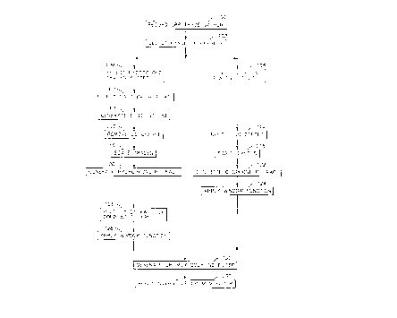
FIG. 3 shows a schematic diagram of the preferred
method of the present invention. Common-receiver-point
(CRP) trace gathers are-recorded, as shown in Block 100.
A middle range of source-receiver offsets is selected for
the seismic survey area, as shown in Block 102.
Preferably, the range of offsets in Block 102 is selected
to yield approximately 10 to 20 traces in each CRP gather
from Block 100 having first-breaks refracted from a common
subsurface horizon. Ten to 20 traces provide a sufficient
number of traces to combine into a slant-stacked trace
yielding a better signal-to-noise ratio than the
individual traces, as will be discussed later.
For each CRP gather from Block 100, the traces in the
hydrophone CRP gather falling in the range of offsets from
Block 102 are selected, generating the hydrophone traces
subset, as shown in Block 104. The traces in the geophone
CRP gather which correspond to the traces in the
hydrophone traces subset from Block 104 are selected,
generating the geophone traces subset, as shown in Block
2192009
106. The first-break peaks of the traces in the
hydrophone traces subset from Block 104 are selected,
generating the set of first-break picks, as shown in Block
108. A least-mean-squared-error straight line in the x-t
plane is fitted to the set of first-break picks from Block
108, generating the best-fit line, as shown in Block 110.
Any nonzero DC offset is removed from both the
hydrophone traces subset from Block 104, as shown in Block
112, and from the geophone traces subset from Block 106,
as shown in Block 114. The DC offset is the average of
all the time sample values in each recorded seismic trace.
Each of the hydrophone and geophone traces subsets is
scanned for the respective highest-amplitude first-break
peak. The traces in both the hydrophone and geophone
traces subsets are scaled to equalize all the first-break
peak amplitudes, as shown in Block 116 and Block 118,
respectively. The signal-to-noise ratio of the individual
traces can be improved by combining the traces in the
traces subsets using a tau-p transform for a single value
of p, i.e., a single slant. The tau-p transform is a
Radon transform using straight lines, which generates a
slant-stacked trace called a p-trace. After correcting
for the static deviation in each hydrophone trace, a
hydrophone p-trace is generated from the scaled hydrophone
traces subset from Block 116, as shown in Block 120.
Similarly, a geophone p-trace is generated from the scaled
geophone traces subset from Block 118, as shown in Block
122. The static deviations are indicated by the time
offset between the set of first-break peaks for the
hydrophone traces subset from Block 108 and the best-fit
line from Block 110.
The Dual Sensor method combines hydrophone and
geophone signals to attenuate the effects of water-column
reverberation. The present invention corrects for the
imperfect geophone coupling mechanism to make the
hydrophone and geophone signals similar enough for
effective combination. Generating hydrophone and geophone
16
21 9~009
p-traces yields traces representative of the hydrophone
and geophone signals, but with better signal-to-noise
ratios than the individual hydrophone and geophone traces.
However, analysis of several data sets from various
locations around the world reveals that the hydrophone and
geophone p-traces generated in Blocks 120 and 122 are
extremely dissimilar in the time period shortly after the
first-break peaks from Block 108. The time at which the
dissimilarity becomes extreme is typically 10 to 20
milliseconds after the first trough and the following peak
in the amplitude of the first-breaks in the hydrophone
traces. The dissimilarity between the hydrophone and
geophone p-traces is greater than can be attributed to the
effect of imperfect geophone coupling mechanism alone.
Thus a window function is applied to limit the combining
of the geophone and hydrophone signals to the time period
in which the two signals are sufficiently similar after
correction for the imperfect geophone coupling mechanism.
Two window functions have been found to work well.
Let t1 be the time of the zero crossing between the first
trough and the following peak on the hydrophone or
geophone p-trace, whichever occurs later. Let t2 be the
time of the next zero crossing after time tl on the
hydrophone or geophone p-trace, whichever occurs later.
A preferred window function has a value of 1.0 from time
t = 0 seconds to the time t2. The preferred window
function can be defined by
0, t < 0
(33)
1, 0 ~ t ~ t2
0, t2< t .
An alternative window function has a value of 1.0 from
time t = 0 seconds to the time t1. From that point in
time forward, the value of the window function
exponentially decays at a rate such that the value at the
2 1 9200q
time t2 is e~2. Thus the alternative window function can
be defined by
0, t < 0
1, 0 s t ~ t1 (34)
exp[-2(t - t )]' tl < t .
The geophone p-trace from Block 122 is multiplied by the
preferred window function of Eq. (33), as shown in Block
124. Alternatively, the geophone p-trace from Block 122
could be multiplied by the alternative window function of
Eq. (34).
The ratio of geophone to hydrophone transfer
functions derived earlier and given by Eq. (32) is applied
to the non-windowed hydrophone p-trace from Block 120, as
shown in Block 126. The ratio of transfer functions in
Eq. (32) provides a measure of the relative effects of the
hydrophone and geophone coupling mechanisms. Because the
hydrophone is well coupled to the water, a natural
freqllency of fm = 2000 Hz and a damping coefficient of
= 0.7 for the hydrophone coupling mechanism are preferably
used. The same window function used in Block 124 is
applied to the hydrophone p-trace from Block 126, as shown
in Block 128.
An iterative, multi-variable search for the geophone
coupling mechanism filter which minimizes the mean-squared
error between the geophone p-trace from Block 124 and the
hydrophone p-trace from Block 128 is performed. The
parameters varied in the search are the natural frequency
fc and damping coefficient ~c of the geophone coupling
mechanism. The search generates an optimum geophone
coupling mechanism filter, as shown in Block 130. A
multi-dimensional downhill simplex method is preferably
used to implement the search. A computer program for the
downhill simplex method can be found in W. H. Press et
al., Numerical Recipes in C, Cambridge University Press,
18
21 9200q
1992. Preferably, the optimum geophone coupling mechanism
filter found in Block 130 is inverted and applied to all
the traces in the original geophone CRP gather of Block
100, as shown in Block 132. Alternatively, the optimum
geophone coupling mechanism filter found in Block 130 can
be directly applied to all the traces in the original
hydrophone CRP gather of Block loO.
If the signal-to-noise ratio of the individual
hydrophone and geophone traces is acceptable, then
generating the hydrophone and geophone p-traces is not
required. FIG. 4 shows a schematic diagram of an
alternative method of the present invention. Common-
receiver-point (CRP) trace gathers are recorded, as shown
in Block 150. For each CRP gather from Block 100, a
hydrophone trace in the hydrophone CRP gather is selected,
generating the hydrophone trace, as shown in Block 152.
The corresponding trace in the geophone CRP gather is
selected, generating the geophone trace, as shown in Block
154. The first-break peak of the hydrophone trace from
Block 152 is selected, generating the first-break, as
shown in Block 156. Nonzero DC offset is removed from
both the hydrophone trace from Block 152, as shown in
Block 158, and from the geophone trace from Block 154, as
shown in Block 160. The geophone trace from Block 160 is
multiplied by the preferred window function of Eq. (33),
as shown in Block 162. Alternatively, the geophone trace
from Block 160 can be multiplied by the alternative window
function of Eq. (34).
The ratio of geophone to hydrophone transfer
~unctions given by Eq. (32) is applied to the non-windowed
hydrophone trace from Block 158, as shown in Block 164.
A natural frequency of fm = 2000 Hz and a damping
coefficient of ~m = O. 7 for the hydrophone coupling
mechanism are preferably used. The same window function
used in Block 162 is applied to the hydrophone trace from
Block 164, as shown in Block 166.
19
21 9200~
An iterative, multi-variable search for the geophone
coupling mechanism filter which minimizes the mean-squared
error between the geophone trace from Block 162 and the
hydrophone trace from Block 166 is performed. The
parameters varied in the search are the natural frequency
fc and damping coefficient ~c of the geophone coupling
mechanism. The search generates an optimum geophone
coupling mechanism filter, as shown in Block 168.
Preferably, the optimum geophone coupling mechanism filter
found in Block 168 is inverted and applied to all the
traces in the original geophone CRP gather of Block 150,
as shown in Block 170. Alternatively, the optimum
geophone coupling mechanism filter found in Block 168 can
be directly applied to all the traces in the original
hydrophone CRP gather of Block 150.
Application of the method of the present invention to
data from three Dual Sensor ocean bottom cable surveys is
illustrated in FIGS. 5 - 7. Fig. 5 shows the series of p-
traces generated by the method of the present invention
for the Gulf of Mexico data. Trace 201 is the hydrophone
p-trace constructed from the hydrophone traces subset.
Trace 202 is the geophone p-trace constructed from the
corresponding geophone traces subset. Trace 203 is the
hydrophone p-trace 201 minus the geophone p-trace 202.
Trace 204 and trace 205 are the hydrophone p-trace 201 and
the geophone p-trace 202, respectively, with the preferred
window function of Eq. (33) applied. Trace 206 is the
windowed hydrophone p-trace 204 minus the windowed
geophone p-trace 205. Trace 206 indicates the degree to
which the attenuation of water-column reverberations by
the Dual Sensor method is compromised by the filtering
effect of imperfect geophone coupling, even after trace
scaling. Trace 207 is the hydrophone p-trace 201 after
application of the optimum geophone coupling mechanism
filter followed by application of the preferred window
function of Eq. (33). Trace 208 is a repeat of the
windowed geophone p-trace 205. Trace 209 is the windowed,
- 21 9200q
filtered hydrophone p-trace 207 minus the windowed
geophone p-trace 208. Trace 210 is a repeat of the
windowed hydrophone p-trace 206. Trace 211 is the
geophone p-trace 202 after application of the inverse of
the optimum geophone coupling mechanism filter followed by
the preferred window function of Eq. (33). Trace 212 is
the windowed hydrophone p-trace 210 minus the windowed,
inversely filtered geophone p-trace 211. The amplitude of
trace 212 is reduced from the amplitude of trace 206 by
over 14 dB. The optimum parameters found for the geophone
coupling mechanism were natural frequency fc = 46.7 Hz and
damping coefficient ~c = 1.36.
FIG. 6 shows the same series of p-traces as FIG. s
for data from a common-receiver-gather from a survey
offshore Gabon. The improvement in Dual Sensor
reverberation attenuation from use of the present
invention is indicated by the reduction in amplitude of
over 12 dB from trace 312 to trace 306. The optimum
parameters found for the gecphone coupling mechanism were
natural frequency fc = 25.5 Hz and damping coefficient ~c
= 1.97.
FIG. 7 shows the same series of p-traces as FIGS. 5
and 6 for a common-receiver-gather from a survey in Lake
Maracaibo, Venezuela. The improvement in Dual Sensor
reverberation attenuation from use of the present
invention is indicated by the reduction in amplitude of
almost 7 dB from trace 412 to trace 406. The optimum
parameters found for the geophone coupling mechanism were
natural frequency fc = 27.3 Hz and damping coefficient ~c
= 2.30.
The present invention has been described with a
certain degree of specificity. Variations will occur to
those skilled in the art which are within the scope of the
invention, which is limited only by the appended claims.