Note: Descriptions are shown in the official language in which they were submitted.
CA 02197333 1997-02-11
wo ~sro63sa ~ ~ ~ ~ ~ .~ ~ rcrn~rs~snobaa
-1-
DIFFERENTIAL GFS GROUND STATION SYSTElVI
The present invention pertains to global positioning systems {GPS), and more
specifically, a ground station for determining satellite-specific pseudo range
error
associated with the satellite signals received by a GPS receiver.
Satellite positioning systems, commonly referred to as global positioning
systems or simply GPS are now well-known in the art. Such specific systems,
for
example, NAVSTAR-GPS are rapidly being used for determination of the
geocentric
position of mobile units, such as water and land vehicles, aircraft and survey
equipment,
to name a few.
In aircraft, GPS systems are being utilized for navigation, flight control,
and air
space control. These GPS systems may operate independently, or in combination
with,
among others, inertial reference systems or attitude heading reference systems
in order
to provide information during an aircraft flight mission.
Global positioning systems similar to NAVSTAR commonly use a GPS
receiver, located on a mobile unit, for receiving satellite information
signals transmitted
from a plurality of satellites. Each GFS satellite transmits an information
signal
containing data that allows a user to determine the range or distance between
selected
GPS satellites and the antenna associated with the mobile unit's GPS receiver.
These
distances and knowledge of the satellite positions are then used to compute
the position
of the receiver unit using known triangulation techniques. For example, in the
NAVSTAR-GPS system, a mobile unit with a GFS receiver, such as an aircraft,
detects
a pseudo random code contained in a given GPS satellite information signal and
derives
therefrom the "elapsed time" or time delay between the transmission of the
satellite
signal and its reception at the GPS receiver. From this time delay, the GPS
receiver
derives the range between the GPS receiver antenna and the satellite,
sometimes referred
to as the pseudo range or pseudo range measurement. Herein, the GPS receiver's
position, or the mobile unit's position, generally refers to the corresponding
antenna
position.
CA 02197333 1997-02-11
WO 96106364 ~ ~ PCTlUS95/10644
-2-
In addition, as part of the NAVSTAR-GPS system, each satellite information
signal also contains precise ephemeris data and course almanac data which both
describe the corresponding satellite orbital trajectory in earth centered
space as is well
known in the art. The coordinates of the satellite's orbital position at the
receiver
measurement time may be derived from either the ephemeris data or the course
almanac
data. T.he geocentric position of the satellite may be calculated with a
higher degree of
precision from the ephemeris data than is possible with the almanac data.
However,
because the ephemeris data precisely describes the satellite trajectory at the
moment of
transmission of the satellite information signal, it is only valid for a few
hours
thereafter, as is well known.
It should be understood that the mobile unit's three-dimensional geocentric
position coordinates in the World Geodetic System Coordinate system may be
determined using either the ephemeris data or almanac data received from four
or more
satellites. Herein, it should be recognized by those skilled in the art that
the World
Geodetic System is an earth-centered, earth-fixed geocentric coordinate
system, which
may be converted to any other coordinate system as required by the user.
Sometimes
the aforementioned coordinate system is referred to as the WGS84 earth-
centered, earth-
fixed, rectangular coordinate frame. Herein, the World Geodetic System
Coordinates
should be presumed, and position refers to this three dimensional WGS84
coordinate
system.
In order to determine the position of the GPS receiver unit, a minimum of four
satellite signals are required, rather than the expected three. This is so,
since the GPS
receiver includes a receiver clock which is not as accurate as the atomic
clock of the
satellites. Therefore, receiving satellite information signals from four
dii~erent satellites
provides a complete solution which permits the correction of any receiver
clock error as
is well understood in the art. Herein, the corrected receiver clock time is
referred to as
the receiver time. Thus, if signals from four or more satellites are available
to the GPS
receiver unit, the geocentric position of the receiver may be determined
within
approximately one-hundred meters of its "true" geocentric position. Herein,
the receiver
position derived by the triangulation technique using data from multiple
satellites is
referred to as the "estimated position". The accuracy of the estimated
position of the
receiver unit is dependent upon many factors including, among others,
atmospheric
CA 02197333 2004-03-30
64159-1502
3 ,
conditions, selective availability, and the relative
position of the satellites with respect to the line of sight
view of the satellites.
Although the satellite positioning system referred
to as GPS is by far the most accurate global navigation
system ever devised, its incredible accuracy can be boosted
using a technique called "differential GPS", sometimes
referred to as "DGPS". DGPS can achieve measurement
accuracy better than a meter. Differential GPS has been
widely used in surveying applications, and now its use is
being developed for aircraft approach and landing
applications.
With regard to the latter, GPS systems standards
have been developed by the Radio Technical Commission for
Aeronautics (RTCA) in association with aeronautical
organizations of the United States from both government and
industry. The RTCA has defined performance requirements for
a DGPS system as particularly identified in Document No.
RTCA/DO-217, dated August 27, 1993; and for GPS performance
requirements for navigation equipment as particularly
identified in Document No. RTCA/DO-208, dated August 27,
1993.
As is well understood in the art, a differential
GPS system incorporates a reference or "ground station"
which includes a GPS receiver's antenna installed at a
surveyed site. The geocentric position of the GPS receiver
is known from surveying techniques. The GPS ground station
receiver determines pseudo range values between the receiver
and a plurality of satellites. Since the position of the
satellite is derived from the satellite data associated with
the satellite signals, and the position of the receiver is
CA 02197333 2004-03-30
64159-1502
4 ,
also known, a calculated range value therebetween may be
determined for each of the tracked satellites. In turn, the
difference between the pseudo range value and the calculated
range value for each of the tracked satellites may be
determined. This difference is commonly referred to as the
"differential correction". The differential correction
value is essentially the pseudo range error between the
"observed" or "measured" pseudo range value derived from the
satellite signal travel time and the calculated range value
between the antenna's position and corresponding satellite
position.
The motivation for differential operation is that
many of the largest GPS error sources, such as selective
availability and ionospheric effects, are common to two or
more receivers operating in spatial and temporal proximity,
since these anomalies affect the satellite signal travel
time. These error sources can be nearly eliminated in the
differential mode, namely determining the differential
correction value or pseudo range error, to greatly enhancing
performance. A differential GPS system is shown and
described in a publication entitled, "Design and Flight Test
of a Differential GPS/Inertial Navigation System for
Approach/Landing Guidance", Navigation: Journal of
Institute of Navigation, Summer 1991, Vol. 38, No. 2,
pp 103-122.
As described therein, these differential
corrections may be transmitted, by any data link technique,
to a mobile unit which incorporates a GPS receiver and
associated antenna experiencing substantially the same
errors in the pseudo range observed values for the same
tracked satellites as the ground station receiver.
CA 02197333 2004-03-30
64159-1502
4a '
Accordingly, the mobile unit's pseudo range observed values
may be corrected by the differential corrections for a more
precise determination of the geocentric position of the
mobile unit. It should be noted that the accuracy of the
corrections is somewhat dependent on the proximity of the
mobile unit relative to the ground station.
Although differential GPS ground stations have
advanced the art of GPS for some applications, there is a
need for a differential GPS ground station with enhanced
integrity, continuity, and availability as particularly
identified in the aforesaid RTCA publication.
One proposed system to enhance integrity is found
in the Conference Proceedings, National Telesystems
Conference 1993. Commercial Applications and Dual - Use
Technology (Cat. No. 93CH3318-3), Proceedings of 1993 IEEE
National Telesystems Conference, Atlanta, GA, USA, 16 - 17
June 1993, ISBN 0-7803-1325-9, 1993, New York, NY, USA,
IEEE, USA, pages 143-152. This system determines if a fault
has occurred and combines into the differential correction
messages only those data sets that are consistent. The
procedure is, however, complicated and is likely to
introduce noise in the resulting signal.
SUMMARY OF THE INVENTION
An object of the present invention is to provide a
differential GPS ground station having enhanced continuity,
availability of function, and integrity.
In the present invention, a plurality of GPS
receivers are operative for receiving selected satellite
signals and deriving from the satellite data associated with
each of the received satellite signals: (i) a receiver-
CA 02197333 2004-03-30
64159-1502
~ 4b '
satellite-specific pseudo range value at a corresponding
receiver-satellite-specific measurement time, where said
receiver-satellite-specific pseudo range value is an
estimate of the true range value between a corresponding one
of said plurality of
CA 02197333 1997-02-11
w qr0 96J063b4 PC"TN895l10644
-$-
satellites to a specific one of said plurality of receivers, and (ii) the
corresponding
satellite position at said receiver-satellite-specific measurement time. The
ground
station further including a differential correction processor which includes a
signal
processor for determining a receiver-satellite-specific calculated range value
where said
calculated range value is the range between the geocentric position of the
ground station
and the geocentric position of the satellite sending the received satellite
signal, and a
signal processor for calculating a receiver-satellite-specific difference
between
corresponding ones of the receiver-satellite-specific calculated range values
and said
receiver-satellite-specific pseudo range values, and a signal processor for
deriving the
satellite-specific pseudo range error associated with each received satellite
signal as a
function of a plurality of the receiver-satellite-specific pseudo range values
associated
with the same satellite.
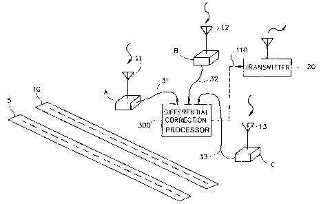
Figure 1 is a schematic diagram of a differential for an aircraft airport
landing
system.
Figure 2 is a schematic diagram illustrating.pseuda ranges and components of
the system of Figure 1.
Figure 3 is a schematic block diagram of the differential GPS system in
accordance with the present invention.
Figure 4 is a schematic block diagram showing further details of the satellite-
specific synchronizing block of Figure 3
Figure 5 is a schematic block diagram showing further details of the satellite-
specific averaging block of Figure 3.
Figure 6 is a schematic block diagram showing further details of the integrity
monitor block of Figure 3.
~LL7l..~\fy( ((~1~ ~~ ~ /' @.I~L s\L~lyll'J'«-'a~ m ~uvuaamuaws
Illustrated in Figure 1 is a schematic diagram illustrating a differential GPS
ground station in accordance with the present invention for application for a
precision
approach landing system for an airport. Thereshown are a pair of runways 5 and
10. In
close proximity to the runways are three (3) remote GPS antenna-receiver units
CA 02197333 1997-02-11
WO 96106364 ~ ~ y PC"T/US951106~14
-6-
identified as receivers A, B, and C, in which their respective antennas 11,
12, and 13 are
in spaced apart arrangement, being approximately 100 meters from each other so
as to
separately receive GPS satellite signals and at the same time minimize any
mufti-path
satellite signals - signal reflections from the earth's surface or earth
surface objects.
Further shown is a differential correction processor 300 responsive to
information from
the remote GPS receivers, A, B, and C for deriving satellite-specific pseudo
range
corrections 110 which may be transmitted to an aircraft or mobile unit by a
data link
transmitter 20.
Figure 2 is an illustration depicting the mechanics of the differential GPS
system
in accordance with the present invention. In the illustration of Figure 2,
three satellites
are shown in order to simplify understanding of the system of the present
invention,
where a minimum of four are generally necessary for a GPS navigation solution,
and
five satellites are generally required for application of a receiver
autonomous integrity
monitoring system. Thereshown in Figure 2 is a first satellite or satellite
vehicle SV 1
which travels the orbital trajectory J1 and is at a position R' (t), having
coordinates
x,y,z. Similarly, thereshown are satellites SV2 and SV3, traveling
trajectories J2 and J3,
respectively, and being at positions RZ(t)and R3(t), respectively. The
satellite
positions are of course time related, and are therefore unique for a specific
time.
Also illustrated are GPS receivers A, B, and C, designated receivers RCVR -#A,
#B, #C, respectively, located at true surveyed positions GA(x,y,z), GB(x,y,z),
and
GC(x,y,z), respectively. Further illustrated is a mobile unit , for example an
aircraft
202, having a GPS receiver designated RCVR-#M, located at a position to be
determined by the GPS satellite triangulation positioning method. Although not
shown,
aircraft 202, or other mobile unit, includes a data-link receiver for
receiving a correction
message from transmitter 20 or the like. The correction message may include
the
pseudo range correction, herein referred to as the differential correction, as
well as the
associated satellite vehicle identification (SV/ID), time of correction,
pseudo range
correction rate. As is understood, the time of correction and the pseudo range
correction
rate may be employed to extrapolate from the time of correction to the time of
application to the mobile unit's GPS receiver information.
Herein, it should be understood that the GPS receiver is intended to determine
the geocentric position of the associated antenna. In the exposition which
follows, the
CA 02197333 1997-02-11
WO 961063b4 ~ ~ ~ 7 3 ~ 3 PCTIUS95114644
_'7_
term "receiver" implies the position of the a~ntenn~a as well as the
associated electronics
or signal processing components for tracking the satellite signals received by
the
antenna. Further, let "K" be the number of GPS ground station receivers in
proximity to
a particular airport runway or spatial location of interest, and let "N" be
the total number
of satellites tracked at a particular measurement time.
As is well understood in the art, each of the satellite vehicles separately
transmits a satellite signal which contains satellite-specific data including
the satellite
vehicle identification number, ephemeris and course almanac data which
describes the
trajectory of the satellite vehicle, the time of satellite signal transmission
health and
status information as is well known. As is understood in the art, ephemeris
data
identifies the most accurate satellite vehicle trajectory information, and
course almanac
data provides geocentric orbital information of the entire constellation of
the satellites
which makes up the NAVSTAR system from which the geocentric position of any
one
satellite may be derived for any instant time.
Each of the GPS receivers is generally operative to provide standard
information
derived from the satellite signal including, among other information,
satellite vehicle
identification number, pseudo range, delta-pseudo range (derived from the
carrier
signal), satellite trajectory information, signal to noise ratio of the
receiver, and the IOD
(issue of data time). Thus, as illustrated in Figure 2, GPS receivers A, B,
and C each
provide unique receiver-satellite-specific pseudo range information to
differential
correction processor 300 in a manner as is will now be described.
GPS receiver A is responsive to the satellite signal transmitted from
satellite
SV 1, and determines therefrom at least the receiver-satellite-specific pseudo
range value
identified as P(t)">', where the superscripts "A,1" refers to the pseudo~range
measurement from receiver A and corresponding satellite "1 ", namely, SV 1.
This may
be mathematically represented by P(t)k>" where "k" represents the designated
receiver
number, and "n" represents the particular satellite and corresponding
satellite signal, and
more particularly the satellite signal travel time, from which the pseudo
range
measurement is derived. In accordance with this nomenclature, for the example
illustrated in Figure 2, ground station GPS receiver A determines pseudo range
values
P(t)">', P(t)">z, and P(t)">3. Similarly, ground station GPS receiver B
determines
pseudo range values P(t)B>', P(t)R>z, and P(t)R>3; ground station GPS receiver
C
CA 02197333 1997-02-11
wo mo~a L ~ ~ ~ ~ ~ ~ rcrms~~o6aa
_g_
determines pseudo range values P(t)'~', P(t)~~2, and P(t)~~3; and mobile unit
receiver
M determines pseudo range values P(t)"'~', P(t)"'~, and P(t)"'~'. In turn,
each of the
ground station receivers provides their respective receiver-satellite-specific
pseudo
range values to differential correction processor 300 on data signal lines
31,32, and 33,
respectively. In order to calculate the differential corrections, processor
300 further
includes the ground station receiver's positions identified as Gk, namely GA,
GB, and
GC.
In the present invention, the differential correction processor 300 is
operative to
calculate the satellite-specific differential corrections CAVC for each
individual tracked
satellite as a function of the corresponding receiver-satellite-specific
pseudo range
values P"''" for the same satellite in a manner as will now be described.
In the description of the Figures which follow, it should be understood by
those
skilled in the art that the block diagrams are only illustrative in nature in
order to
enhance understanding of the present invention. More specifically, the blocks
illustrated may be combined as part of a single microprocessor or a computing
device.
The interconnections between the blocks shown are intended to represent data
being
transferred between selected components or software program blocks or modules
as is
well known in the art. Lastly, timing diagrams have not been shown and have
been only
loosely been implied in order to not obfuscate the present invention.
Nevertheless, the
present invention employs "feedback" and/or "stepwise" processes and the like.
Referring now to Figure 3, thereshown is a differential correction processor
300
having as inputs the individual receiver-satellite-specific pseudo range
values P(t;")k,",
where t", is the corresponding receiver-specific measurement time which may
also be
denoted t ; . Also, from each of the receivers is a corresponding satellite
position value
R(t",)"corresponding to the satellite geocentric position at the pseudo range
measurement time tn .
Differential correction processor 300 includes a satellite position based
range
calculation block 310 which computes the receiver-satellite-specific true
range value
between the geocentric position of the individual receiver Gk and the
geocentric position
of the satellite R(t",)" at time t", for each receiver and each tracked
satellite as
mathematically described as:
CA 02197333 1997-02-11
wo ~sro6~ua ~ ~ ~ % ~ ~ ~ rc~rms9snoba4
-9_
rt k"=Rt "-Gk
( n~ ~ colt' ( m )
In turn, a receiver-satellite-specific differential correction C(tn,)k"is
calculated
by raw differential correction block 320 as a function of the receiver-
satellite-specific
pseudo ranges P(tn,)k" and the receiver-satellite-specific true range
calculation r(tn,)~;~
as follows:
~'~~tnnk~~ - P(tm)k~l' - r(tm)calc
The raw differential corrections C(tn,)k'' includes, however, any receiver-
specific clock bias. As illustrated in Figure 3, correction bias block 330
serves to
calculate the receiver specific clock bias for each of the receivers. One
technique for
determining receiver-specific clock bias is to first compute the average
receiver-
1 S satellite-specific differential cornection separately for each receiver,
namely:
N
L c(r)x.n
~~(tm)avg = n.l N ~~ = l,..x
In turn, these receiver-specific differential correction averages may be
passed
through a low pass filter (not shown) to arrive at a receiver-specific clock
bias value
CB(tn,)bias included in the raw receiver-satellite-specific differential
correction values
P(tn~)k'"'
In turn, the receiver-specific bias value may be subtracted from each of the
receiver-satellite-specific raw differential corrections for the same receiver
in function
block 340 to provide differential correction values corrected for receiver
clock bias,
designated C(tn,)k,"'h, meaning receiver-satellite-specific differential
corrections without
clock bias.
It should be noted that receiver-satellite-specific differential corrections
have
associated therewith the specific receiver measurement clock time t» at which
the
receiver-satellite-specific pseudo range measurements are measured. Since
there may
CA 02197333 1997-02-11
WO 96106364 ~ ~ ~ ~ PC'T/US95/10644
-10-
be a difference between the receiver measurement clock times, each of the
differential
corrections C(tn,)%;~,'b preferably needs to be synchronized or extrapolated
to a common
synchronization time tSrNC , for example the medium time of all of receiver
measurement times. Illustrated in Figure 3 is a measurement time
synchronization
block 400 which serves to adjust each of the receiver-satellite-specific
differential
corrections (without clock bias) to a common time, the details of which are
illustrated in
Figure 4
The purpose of the synchronization block 400 is to correct those values of the
differential corrections C(t", ) wo for variations in the receiver measurement
times. This
is accomplished by first establishing a synchronization time tsrNO ,
calculating the rate
of change of the differential corrections, and subsequently adjusting the
values of the
differential corrections to be all at the singular synchronization time tSYNC
Referring now to Figure 4, thereshown is time synchronization function block
400, including medium time selection block 410 responsive to the measurement
times tn
of each of the receivers. The synchronization time may be selected by a
variety of
schemes including those in which an average time or the medium time of all
receiver
measurement times is selected, and identified as the synchronized time tSrN~ .
In the
preferred embodiment of the invention the medium time is determined. In turn,
differential block 41 S calculates the time difference between the
synchronization time
tsrNC and the receiver measurement time t ;, having an output identified as
tde,~ok.
In order to synchronize the differential corrections to a common time, the
receiver-satellite-specific differential correction rate is calculated in
block 430 and may
be mathematically expressed as follows:
k,n _ k,n
2C C(t )k,n _ C(trn new ) wnh C(tm old ) woh
J n' (tm new) (tm old
In turn the differential corrections, without bias, are adjusted to the
synchronized
time by correction synchronization block 445 which computes the desired value
which
may be mathematically expressed as follows:
k,n _ k,n ~k,n*
3~ C(tSYNC' ~ - ~',(tm~woh -C tdebo
CA 02197333 1997-02-11
yy0 861(16364 ~ ~ 3 PCT/US95110644
-11-
These values are receiver-satellite-specific differential corrections which
have been
adjusted to be valid for a common receiver measurement time tS,.NC and
adjusted for
receiver clock bias.
It should be noted that the correction values C{tn,)W h used in the
calculation of
C(tSYNC )k'" assumes a proper clock bias correction CB(t",)b;~. However, this
clock bias
may tend to change in a stepwise fashion due changes in the tracked
satellites, more
particularly to an increase or decrease in the number of satellites being
tracked. In turn,
if the rate values are in error due to these variations in clock bias, then
such errors will
ripple through the synchronized differential corrections. Accordingly, it is
preferable to
employ a mechanization to correct for step changes in the clock bias and
subsequent
errors in the differential corrections C(t," ) W;;h upon occurrence of changes
in tracked
satellites. A mechanization for such correction is depicted in Figure 4, and
more
specifically embodied in satellite decision block 490 and step correction
block 495.
Decision block 490 is intended to monitor the plurality of the ground station
I S receivers for detecting a change in the number of satellites, either
increasing or
decreasing. If there is a change, then block 49S is initiated to process the
receiver-
satellite-specific differential correction values without bias to correct them
for those step
changes in the clock bias value CB(tp,)b,a~ caused by the change in the number
of
tracked satellites. For example, if the number of satellites decreases, it is
preferable to
recalculate the clock bias without the specific data associated with the
satellites which
are no longer tracked and recompute those differential corrections previously
corrected
with an erroneous clock bias, and such values are identified as C(tm ) ";""b .
Similarly, if
additional satellites are tracked, then it is preferable to first recalculate
the clock bias
without the additional satellite data and correct those remaining differential
corrections
as before, and secondly correct those differential corrections associated with
the newly
added satellite separately with the newly arnved at clock bias, or
alternatively with
linearly changing clock bias as more cycle times or measurement sample times
continues. There are, of course, many variations to achiueve the intended
function so that
the value of the differential correction rate is appropriately applied to
achieve the
intended synchronization or extrapolation of the differential corrections,
without clock
bias, to a common time.
CA 02197333 1997-02-11
WO 96/06364 ~ I ,~ ~ 5 5 PCTIUS95110644
-12-
Referring again to Figure 3, the receiver-satellite-specific differential
correction
values, without bias an extrapolated to a common time, C(tSyN~ )k", from block
400 are
in turn processed by satellite-specific averaging block S00 for calculating
satellite-
specific differential corrections which may be mathematically expressed as
follows:
K
k,n
C(1SYNC )
C(tSrNC )~,avc = k ~ K I n = 1,.. N
Further details of averaging block 500 are illustrated in Figure 5.
As illustrated in Figure 5, satellite-specific correction averaging block 500
includes a satellite specific averaging block 510 which serves to calculate
the satellite-
specific differential correction values C(ts,.N~ )avc as a function of the
individual
receiver-satellite-specific corrections C(tSrNC )k'~ on data line 490.
Satellite-specific
averaging block 510 further includes a data select input 690 from integrity
monitor 600
as will be subsequently described in further detail as particularly
illustrated in Figure 6.
1 S Block 510 is intended to compute the satellite-specific correction values
and output
them on data signal line 511 in a manner as aforesaid.
Also illustrated in Figure 5 as part of satellite=specific correction
averaging
block 500, are function blocks for computing the satellite-specific first and
second
derivatives of the differential corrections. As illustrated, first derivative
averaging
block 520 is shown responsive to the differential correction rate values
C(tn,)k" on data
signal line 435 as previously computed by correction rate function block 430
for
computing the average as follows:
K
k,n
~C(tn,)
C t " - k-' In=1 ..N
( m)AVG -
The second derivative is determine in block 540 as follows:
k,n _ ~ k,n
C (tnt ) k y = C(tm new ) woA C(tm old ) woA
(tm new) (tnr new)
CA 02197333 1997-02-11
Wp 96/06364 ~ ~ ~ ~ ~ PCTlU895I10644
-13-
In turn, the rate of change of the differential correction rate values C(t~,
)""' is
averaged in function blocks 560 in the same manner as blocks S 10 and 520.
These
values may be outputted on data lines 521 and 561 respectively.
The differential global positioning system in accordance with present
invention
may further include an integrity monitor as designated by block 600 in Figure
3, the
details thereof illustrated in Figure 6. The integrity monitoring function
serves to
validate use of specific satellite-specific differential correction
measurements which, of
course, are derived from receiver-satellite-specific pseudo range measurements
or
values, for enhancement of the differential GPS ground station integrity to
meet the
requirements of the aforesaid RTCA requirements. In particular, mufti-path
errors
produced by the GPS receivers may be detected an eliminated as will
subsequently be
described.
Illustrated in Figure 6 is one technique for implementing an integrity monitor
for
1 S use with the differential GPS ground station in accordance with the
present invention.
As illustrated in Figure 6, thereshown is integrity monitor 600 responsive to
the
satellite-specific differential correction values C(t,~YN~. ) AVC on data line
511 and also the
receiver-satellite-specific correction values C(tSY;,~, )k"on data line 490.
Difference
function block 610 calculates the individual receiver-satellite-specific
deviations as
mathematically described as follows:
devk" = C~tSYNC )r.IVG C~tSYNC )k~
In turn, each of the receiver-satellite-specific deviations devk" are compared
in
block 620 with a detection threshold value DT, the output of detection
threshold
function block 650.
Detection threshold function block 650 may employ a variety of error threshold
schemes to enhance the integrity of the differential GPS ground station in
accordance
with the present invention. For example, in the most simple manner, detection
threshold
block 650 may simply output a constant value DT. The value DT may be
determined by
CA 02197333 1997-02-11
WO 96/(N63G4 ~ 1 ~ PC"TIUS95/10644
-14-
estimates of GPS receiver signal noise and appropriate approximations by
Gaussian
probability distribution functions. For example:
DT = 2Q-~ (Pnld l 2)
where,
P~~,,=2Q (DTIa~,)=2~ f ezdt
which relates the noise error is the discriminator, namely each of the
respective
receivers.
As noted in Figure 6, comparator 620 compares the deviation values devk~"with
the threshold detection value DT. If the value devk~" is greater than DT,
comparator 620
provides as an output D"''" on data line 675 which represents the particular
satellite-
receiver-pair "k,n" having a corresponding differential correction value
C(tn,)k" which
1 S has been found to be faulty, or more specifically, failed the integrity
monitor detection
threshold test. Having knowledge of which receiver-satellite-specific
measurement is
potentially in error, for example, due to random signal noise, allows for the
differential
computations to be re-evaluated without including the discrete values which
fail the
threshold detection test.
The employment of the integrity monitoring function of block 600 is
particularly
illustrated in Figure 5. Thereshown is data lines 690 presented to each of the
averaging
blocks 510, 520, and 540. These averaging blocks are so configured so as to be
responsive to the Dk'" data for appropriate elimination of the specific
receiver-satellite
values, "k,n", which form the averages, and permits the subsequent averaging
calculations without the faulty ones and thereby enhance the integrity of the
satellite
specific differential corrections, and rate values on data lines 511, 521, and
541. In this
manner, the determination of the satellite-specific correction values have
enhanced
performance since they are continuously responsive to the dynamics of the GPS
system
with respect to the receivers for tracking specific satellites at any
particular moment.
CA 02197333 1997-02-11
219~33~
-15-
As illustrated in Figure 6, the detection threshold block may be responsive to
the
values of D"'~' for refining the detection threshold value DT - that is, for
example, the
signal noise values of the those receivers may be a direct function of the
value of DT,
and faulty receiver-satellite-specific values may be eliminated in the
aforedescribed
calculations.
In should be noted that the averaging disclosed herein. may be altered and
such
embodiments are intended to be within the true spirit and scope of the present
invention.
For example, averaging blocks 510, 520, and 560 may be implemented by a wide
variety of filtering techniques, for example a Kalman filter using a random
acceleration
third order state model. The filter design parameter (process and measurement
noise
variances) may be chosen to filter receiver noise without jeopardizing the
ability of the
filter to track variations due to selective availability (SA) errors.
Although not shown in the Figures, employment of data smoothing techniques is
also within the scope of the present invention. Smoothing techniques are well
known
and may be of the variety illustrated in the above referred to publication
which employs
use of the high frequency values of delta pseudo ranges as commonly derived by
the
GPS receiver from the satellite signals.
In summary, the differential global positioning system in accordance with the
present invention has employed a plurality of GPS receivers, preferably three
for fail-
operative mode, to obtain independent receiver-satellite-specific differential
corrections.
Namely, a set of differential correction values for each satellite derive by
each receiver.
Each of differential correction sets, one for each receiver, is formed as
follows: range
calculations are determined using the surveyed positions of each of the
receivers
antennas and the receiver's output of the satellite vehicle's position or
trajectory
information. Raw differential correction values axe then determines as the
difference
between the calculated range value and the appropriate pseudo range values
determined
by the GPS receiver. From these raw differential correction values are
subtracted and
estimate of the clock bias error contain therein by subtracting a heavily
filtered value of
the receiver-specific average of all of the receiver-specific pseudo range
values for the
tracked satellites. In turn, these values are processed by a selected
averaging or filtering
scheme to determine satellite-specific differential corrections, and/or
differential
CA 02197333 1997-02-11
WO 96/06364 ~ Z ~ PC"T/US95l10644
~~ ~73.~~
-16-
correction rates which in turn may be transmitted to a remote mobile unit,
such as an
aircraft in a well known manner.
The differential global positioning system in accordance with the present
invention further includes integrity monitoring for determining those receiver-
satellite-
specific values which may be erroneous or faulty. This may be accomplished by
application of deviation test relative to a selected detection threshold
value. This test
may be applied generally to each receiver-satellite-specific differential
correction value
by examining the deviation between the receiver-satellite-specific
differential correction
value and the mean of the satellite-specific differential correction values. A
failure of
the test results in certain receiver-satellite-specific differential
correction values to be
discounted or eliminated, and subsequent recomputing of the averages. It is
this
resultant average that may be transmitted to the mobile unit's GPS receiver
for
differential correction of the pseudo ranges determined therefrom.
As is well understood in the art, a single electronic/software subsystem may
be
employed for performing the appropriate calculations and generation of the
satellite-
specific differential corrections and integrity monitoring function is
intended to be
within the true spirit and scope of the present invention.
Lastly, although the present invention is intended to be operative with the
NAVSTAR GPS system, other positioning systems are also within the true spirit
and
scope of the present invention. More specifically, any such satellite system
by which
geocentric position information is derived from satellite information signals
is intended
to be within the true spirit and scope of the present invention.
CA 02197333 2004-05-27
64159-1502
16a
In accordance with one aspect of this invention,
there is provided a DGPS for use with a plurality of
' satellites each transmitting information including satellite
position (R) and the time~.of transmission: a plurality of
receivers whose positions (G) are known, the receivers
operable to produce pseudo range values (P) indicative of
the distance between receiver and satellite based on the
transit time of the signal from satellite to the receiver;
range calculation means operable to produce calculated range
values (Racal) from the difference between G and R;
differential correction means receiving the Racal and P
values to produce differential correction values (C);
averaging means connected to receive the differential
correction values and to produce average differential
correction values (Cave); and integrity monitoring means
connected to receive to receive only C and Cave and to
produce a fault signal if the difference therebetween
exceeds a threshold value.
In accordance with another aspect of this
invention, there is provided a differential satellite
positioning system ground station operative for determining
a satellite-specific pseudo range error associated with each
received satellite information signal transmitted from
selected ones of a plurality of satellites, where "n"
represents a specific one of said plurality of satellites,
said differential satellite positioning system ground
station comprising: a plurality of GPS receivers, where "K"
represents the total number of said plurality GPS receivers
and where "k" represents a specific one of said "K" GPS
receivers and wherein eacYi.one of said plurality of GPS
receivers, i) is independent of each other, ii) is operative
for receiving a satellite information signal from each of
selected ones said plurality of satellites, iii) has a known
CA 02197333 2004-05-27
64159-1502
16b
geocentric position, identifies as Gk, and iv) is in spatial
proximity to a spatial location of special interest, v) is
' operative for deriving from satellite data associated with
each received satellite information signal at least a
geocentric satellite position, identified as R(tm)", at a
receiver-specific measurement time, identified as tm, of the
specific satellite, "n", transmitting the satellite
information signal, and vi) is operative for deriving from
satellite data associated with each received satellite
information signal at least a satellite-receiver-specific
pseudo range value identified as P(tm)k,° where k and n
represent said specific GPS receiver and satellite,
respectively, and tm corresponds to said receiver-specific
measurement time, and where said satellite-receiver-specific
pseudo range value is an estimate of the true range value
between a specific GPS receiver, "k", and a specific
satellite , "n", derived,from said satellite information
signal and related to the corresponding satellite signal
travel time from the specific satellite to the specific GPS
receiver; and a differential correction processor including,
means for determining receiver-satellite-specific calculated
range values, identified . as r (tm) calck~n~ where each receiver-
satellite-specific calculated range value is the difference
between (i) corresponding "k" and "n" ones of said
geocentric receiver position G'' of a specific GPS receiver,
"k" and (ii) said satellite position R(tm)° of a specific
satellite, "n" at a corresponding receiver-specific
measurement time, tm, means for calculating corresponding
receiver-satellite-specific difference values, identified as
(tm)k,", each being the difference between (i) corresponding
"k" and "n" ones of said-.receiver-satellite-specific
calculated image values, ~ (tm)calck~"~ and (ii) said
satellite-receiver-specitic pseudo range values, p(tm)'',n,
:.
CA 02197333 2004-05-27
64159-1502
16c
means for deriving said satellite-specific pseudo range
error associated with said satellite information signal
transmitted from each of said selected plurality of
satellites as an average of said receiver-satellite-specific
difference values, C(tm)k,n derived by selected ones of said
"K" GPS receivers for each of said selected ones of said
satellite information signals; and integrity monitoring
means comparing the difference between the
receiver-satellite specific difference values with the
average of said receiver satellite-specific difference
values and producing a fault signal if the difference is
greater than a predetermined threshold value.
In accordance with yet another aspect of this
invention, there is provided a differential satellite
positioning system ground station operative for determining
a satellite-specific pseudo range error associated with each
received satellite information signal transmitted from at
least first and second satellites each transmitting a signal
indicative of its position, said differential satellite
positioning system ground station comprising: a first
receiver for receiving the signal from the first and second
satellites and to calculate first and second true ranges,
one for each of the distances between the first receiver and
the first and second satellites, respectively, and to
calculate first and second pseudo ranges, one for each of
the distances between the first receiver and the first and
second satellites, respectively, said first receiver
calculating a first error. signal representing the difference
between the first true range and the first pseudo range, and
a second error signal representing the differences between
the second true range and the second pseudo range; a second
receiver located proximate the first receiver to receive the
signals from the first and second satellites, and to
CA 02197333 2004-05-27
64159-1502
~16d
calculate third and fourth true ranges, one for each of the
distances between the second receiver and the first and
' second satellites, respectively, and to calculate third and
fourth pseudo ranges, one for each of the distances between
the second receiver and the first and second satellites,
respectively, said second receiver calculating a third error
signal representing the difference between the third true
range and the third pseudo range, and a fourth error signal
representing the differences between the fourth true range
and the fourth pseudo range; means for computing a first
average being the average of said first and third error
signals and for computing a second average being the average
of the second and fourth error signals and integrity
monitoring means comparing the differences between the first
and third error signals and the average of said first and
third error signals and comparing the difference between the
second and fourth error signals and the average of the
second and fourth error signal and producing a fault signal
if the differences exceed a predetermined threshold value.
In accordance with a further aspect of this
invention, there is provided a differential satellite
positioning system ground station operative for determining
a satellite-specific pseudo range error associated with each
received satellite signal transmitted from a plurality of
satellites, the ground station comprising: a plurality of
GPS receivers operative for receiving selected satellite
signals and deriving from the satellite data associated with
each of said received satellite signals at least i) a
satellite-receiver-specific pseudo range value at a
corresponding receiver-specific measurement time, where said
satellite-receiver-specific pseudo range value is an
estimate of the true range value between a corresponding one
of said plurality of receivers and one of said plurality of
CA 02197333 2004-05-27
64159-1502
16e
satellites derived from said satellite signal and related to
the corresponding satellite signal travel time from the
' specific satellite of said plurality of satellites to the
specific receiver of said plurality of receivers, and ii)
the corresponding satellite-receiver-specific position of
said one satellite at said satellite-receiver-specific
measurement time; and a,differential correction processor
including, means for determining a
receiver-satellite-specific calculated range for each
receiver and each of said selected satellites, where said
calculated range is the range between corresponding ones of
the geocentric position of each of said plurality of
receivers and the satellite-receiver-specific geocentric
position of each of said.satellites, means for calculating a
receiver-satellite-specific difference between corresponding
ones of said receiver-satellite-specific calculated ranges
and said satellite-receiver-specific pseudo range values,
and means for deriving said satellite-specific pseudo range
error associated with said satellite signal transmitted from
each of said selected plurality of satellites as a function
of a plurality of said satellite-receiver-specific pseudo
range values from said plurality of GPS receivers and
associated with a specific one satellite, means comparing
the satellite-specific pseudo range error with the average
of all of the satellite-specific pseudo range errors to
produce individual receiver-satellite specific deviations;
and integrity monitoring means comprising means for
comparing the satellite-specific deviations with a
predetermined threshold value and producing a fault signal
whenever a satellite-specific deviation exceeds the
predetermined threshold value.