Note: Descriptions are shown in the official language in which they were submitted.
CA 02219010 1997-10-17
METHOD FOR AN AUTOT~IATED VISUAL RANGE MEASUREMENT
BY MEAN;i OF A LIDAR SYSTEM
FIELD OF THE INVENTION
The present invention relates to a method for an
automated visual range measurement by means of a LIDAR system.
REVIEW OF THE RELATED TECHNOLOGY
LIDAR (LIght Detection And Ranging) constitutes an
optical synonym to the conamonly known "radar" and describes
laser-based remote sensing techniques that can be used to
measure atmospheric paramEaers. A further development of the
LIDAR technology via the distance measurement of diffuse
scatterers, such as cloud:, with the aid of so-called cloud
altitude meters has resulted in a system for the rangeresolved
measurement of an atmospheric turbidity with the aid of a
visual range (visibility) measuring device. Miniaturization of
the LIDAR systems subsequently resulted in compact and hence
mobile LIDAR systems which can be housed inside a measurement
bus or even a passenger vE:hicle, or be set up to take
measurements from a freeway bridge.
The problem of t:he danger to the eyes resulting from
the high-energy laser beams was eliminated with the
implementation of fast-pulsing laser diodes with a low pulse
energy emission.
A LIDAR system Esssentially consists of three main
components: a transmitter to emit a laser light, a receiver to
collect the backscattered radiation, and converter electronics
to produce an interpretable signal from the collected amount
of light.
The transmitter emits brief light impulses in the
range of several nanoseconds (ns)~; the light-impulse packages
(or, packets) are reflected along their path through the
atmosphere by particles such as dust, droplets of water, etc.
and return to the receiver after a certain amount of time.
CA 02219010 2000-02-28
Based on this time delay, the range volume in which the
scattering took place can be precisely localized down to half
the pulse length of the light (back and forth travel). The
reflected amount of light received in each range interval then
becomes a measure for the number of particles responsible for
a turbidity in the atmosphere.
Up to now the evaluation of the obtained
measurements could only be performed by a trained expert.
SUI~ARY OF THE INVENTION
Accordingly, the present invention has an object,
among others, to overcome deficiencies in the prior art such
as noted above.
It is therefore the aim of the invention to describe
a method by which the respective visual range (visibility) is
measured automatically.
In one aspect of the invention there is provided a method for automated
measurement of a visibility distance comprising steps of:
providing a LIDAR system including an electronic processor (3), a light
2o beam transmitter (1), and a reflected light beam receiver (2), the receiver
outputting a voltage level U(R) proportional to an amount of received light
reflected from the atmosphere up to a distance R from the receiver;
(a) on startup, estimating, from a range of detected voltage levels U(R),
a maximum measuring range distance Rm over which an algorithm is to be
calculated, and estimating an initial starting value of an attenuation
coefficient
6(Rm)~
(b) after startup, repeatedly replacing a previous starting value with a
new starting value by iterative steps further comprising
1) calculating a new attenuation coefficient 6(R) according to a
3o Klett equation
S(R)
~(R) - S(R )
"' + 2 jS(r)dr
cr(R," ) R
2
CA 02219010 2000-02-28
where S(R) is a range-adjusted signal proportional to the voltage level
U(R),
2) averaging previously calculated attenuation coefficients
to obtain a mean attenuation coefficient,
3) taking a difference of the mean attenuation coefficient
and the new attenuation coefficient, and
4) repeating the iterative steps if the difference is greater
than a predetermined amount; and
(c) if the difference is less than a predetermined amount,
calculating the visibility distance from the mean attenuation coefficient.
Another aspect of the invention provides a method for automated
measurement of a visibility distance comprising steps of:
providing a LIDAR system including an electronic processor (3), a
light beam transmitter (1), and a reflected light beam receiver (2), the
receiver outputting a voltage level U(R) proportional to an amount of
received light reflected from the atmosphere up to a distance R from the
receiver;
(a) estimating an initial starting value of at least one quantity
related to the visibility distance;
(b) repeatedly replacing a previous starting value with a new
starting value by iterative steps further comprising
1) calculating a new value of the quantity,
2) averaging previously calculated quantities to obtain a
mean new quantity,
3) taking a difference of the mean quantity and the new
quantity, and
4) repeating the iterative steps if the difference is greater
than a predetermined amount; and
(c) if the difference is less than a predetermined amount,
calculating the visibility distance from the mean quantity.
2a
CA 02219010 2000-02-28
BRIEF DESCRIPTION OF THE DRAWING
The above and other objects and the nature and
advantages of the present invention will become more apparent
from the following detailed description of an embodiment[s]
taken in conjunction with drawings, wherein:
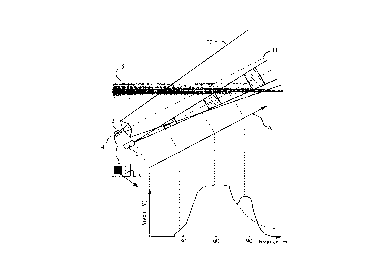
Fig. 1 is a view of the invention.
DETAILED DESCRIPTION OF THE PREFERRED E1~ODIMENT
A LIDAR system according to the present invention
includes the usual transmitter 1 to emit a laser light,
receiver 2 to collect the backscattered radiation, and
converter electronics 3 to produce an interpretable signal
from the collected amount of light.
The drawing contains, in its lower portion, a
sketched graph of a typical received-light signal, with the
voltage (V) of the signal shown on the ordinate and the
2b
r
CA 02219010 1997-10-17
distance in meters (m) plotted on the abscissa. The distance
is proportional to the actual distance from the transmitter 1
because the speed of light: is essentially constant; arrow line
A indicates schematically the transfer from the beam line
distance to the abscissa.
Three events can be identified in this received
signal:
a) No radiation can be measured up to a distance of
approximately 30 m. The receiver cannot "see" any light from
the transmitter because the transmitter cone 11 has not yet
entered the reception cone: 22. This blind range is based on
the opening as well as on the spacing between the transmitter
and receiver optics. The pulses are indicated by cross-
hatching.
b) At a distance: of 60 m, a peak is formed which
corresponds to the normal turbidity of the atmosphere and thus
to the visual range (visibility).
c) An additional. peak appears at 90 m, indicating a
layering of the atmosphere:, for example in the form of a fog
bank, labelled as 5. Without such a layering the signal would
have followed the course indicated by the dashed line in the
drawing.
As sketched in the drawing, the collected amount of
radiation depends on the number of scatterers and the
attenuation by the atmosphere, which means the higher the
number of scatterers, such as fog droplets, the higher the
amplitude of the received signal. However, this quantitative
statement is not always sufficient to determine the quality of
a backscattering and, consequently, the actual visibility. The
backscattering characteri:>tics of the particles would play too
large a role in a quantitative measurement of the visibility,
i.e. in a measurement of the maximum intensity. A minute
triple reflector, acting 7_ike a cat's eye, for example, would
simulate the presence of a solid wall to the system.
However, the turbidity mentioned above can also be
determined via another measurable variable: the attenuation
3
CA 02219010 1997-10-17
of the atmosphere. Said attenuation is reflected by the
negative gradient of the measurement curve, which can also be
seen in the drawing. Withc>ut the additional turbidity, which
may be caused by a fog bank, for example, the measurement
curve would follow the dashed line, as mentioned above. The
fog bank, however, produces a strong attenuation and hence a
steeper decline of the curves.
Analytically, the two values, i.e. the backscatter
and the attenuation, may be described with the following
equation (1) for the case of a single scattering:
U~R) = Rz ~~R)WR)z~l~)2 ( 1 )
In equation (1), U(R) denotes a digitized signal
(for example from the receiver 2 to the processor 3), R
denotes a measuring range, k denotes an instrument constant
(which is used to take into consideration the amplification,
the emitted laser radiation, etc.), ~(R) denotes an optical
overlap function due to geometry (in the drawing, the close
range up to approximately 60 m), (3(R) denotes a backscattering
from a distance R, and i(R)2 denotes a loss through
attenuation or transparency along the back and forth travel,
given by equation (3) below. The attenuation factor is
expressed as a squared quantity, because the light travels
forth and back on the same path.
The range R is a variable, generally equal to the
distance from the transmitter 1 or receiver 2 as determined by
the pulse travel time. The quantity U is proportional to the
amount of light received, at the light detector 4 of the
receiver 3., from a parcel of air bounded a distance R away.
For each value of R past the point where the cones 11 and 22
fully overlap, the signal strength is the product of the
backscatter and the attenuation. Because the light scattered
from a parcel of air at a distance R goes in all directions
4
CA 02219010 1997-10-17
4
(not only toward the receiver 2), the quantity U follows the
inverse square law, being proportional to 1/R2.
Because of the digitization (sampling), the
respective measuring range: R is a multiple of a sampling rate
fs of the ADC and half the speed of light (because of the back
and forth travel) according to equation (2):
c
R-~2.f (2)
s
where n denotes the sample number, and C is the speed of
light.
The transparency of the atmosphere can also be
expressed via the attenuation with the following equation (3):
R
z(R)2 = exp(-2 f ~(r)dr) ( 3 )
r=0
where a(r) denotes an attenuation coefficient or extinction at
the location r.
In the determination of a visual range (visibility)
with the aid of LIDAR technology, a location-resolved
measurement of a reception intensity or voltage U(R),
respectively, provides the visibility according to equation
(4), whereby, however, the visibility is at the same time also
contained in the two unknown measurement variables, i.e. in
the backscattering in the form of the volume backscatter
coefficient (3(R), and in the attenuation coefficient
(extinction) a(R):
V(R) 6(R) lnC s/ ( 4 )
where V(R) denotes a visibility and sdenotes a
5
" CA 02219010 1997-10-17
contrast threshold value (based on a standard visual range of
20 or a meteorological visibility of 5~, respectively.)
Furthermore, the following applies in accordance with equation
(5) for the volume backscatter coefficient [3(R):
WR) _ ~ WR) ( 5 )
where P denotes a backscatter phase function which is
dependent on the respective scattering medium.
The above equation (1) is then rewritten into a
range-adjusted signal, called the signature for an additional
calculation according to equation (6):
I~~l _R_l
The measured values (3 and i are thus separated from
the known quantities U, R, k and also ~, whereby the variable
is predetermined by the geometry of the system.
A differentiation of the logarithmic signature and
consideration of equation (3), according to the equation (7),
results in
aln(S(R)) _ 1 a~3(~)
yR) ~ 2~(R)
The solution of 'the differential equation (7) with
consideration of equation (5) then corresponds to equation
(g)
6
" CA 02219010 1997-10-17
a-(R) - S(R)
S(Ro) R ($)
~(R ) - 2 f S(r)dr
0 0
where Ro denotes a minimal distance, the beginning of an
optical overlap, and ~(Ro) denotes an approximated value for
the local extinction in the vicinity of the measuring
instrument.
Under certain circumstances the solution of the
equation (7) produces very small and sometimes also negative
values in the denominator, for example due to noise, which
means that the solution is instable.
A stable solution of equation (7) is obtained by
transposing the integration thresholds with the aid of the
Klett equation (J. D. Klett, Stable Analytic Inversion Solution
for Processing LIDAR Returns, Applied Optics 20, 211, 1981)
according to equation (9):
S(R) (9)
o-(R) - S(R ) RM
"' + 2 f S(r~)dr
o'(Rm ) x
where Rm denotes a maximum measuring range (based on the noise
level) and a(Rm) denotes an estimated value for the local
extinction at the end of the measuring range.
A start value (or, starting value), i.e., an
estimated value for the extinction, must in this case be
determined at the end of the measuring range (Rm). While this
method in fact contradicts the LIDAR method, i.e., the optical
range measurement, it is nevertheless applied since it
represents the only stable solution of the equations (1) and
(7), respectively. Furthermore, the division results in the
elimination of the instrument constant k and the phase
7
CA 02219010 1997-10-17
function according to equation (5), unless these values are
location-dependent.
It is thus possible with the aid of a LIDAR system
to measure the visibility or the turbidity of the atmosphere,
respectively, with the aid of the attenuation;
this, however, under the precondition that the attenuation is
not so strong that it immediately fades out the entire
radiation.
Although equation (9) does represent the stable
to solution of equation (7), the calculation of the individual
extinction values a(R), and consequently of the visibility, is
strongly influenced by the value S(Rm)/ a(Rm).
The received intensity is converted, with a detector
4, to an electrical signal which is first amplified and then
digitized. The digital values are fed to a computer of
electronics 3 for post-processing.
The implementation of a stable and automated
evaluation algorithm requires several analysis steps:
First, a measuring range to be evaluated must be
selected from the voltage range U(R) according to equation
(1). In the course of this step, the minimum measuring range
and specifically the maximum measuring range Rm are determined
based on the respective voltage level U(R).
Additionally, the voltages or voltage levels U(R),
respectively, are continually compared to a certain threshold
value from the beginning of the measuring range, starting with
the first sample, until this threshold value is exceeded. The
threshold value depends on the instruments, particularly on
the amplifier and the analog-digital-converter and also on the
optical overlap function.
The voltages or ~JOltage levels U(R), respectively,
for the maximum range Rm are then also compared to the same
threshold value, however, in this case starting with the last
sample. The process is additionally also observed regarding
the possible existence of a solid target, such as a wall. If
such a solid target exists, the respective scanned values are
skipped in the direction of the receiver (the direction in
8
" CA 02219010 1997-10-17
which the sample numbers decline). In this context the number
of scanned values depends on both the duration of the
impulses, as well as on the receiver bandwidth. The scanned
values must be skipped since the inclusion of the solid target
voltages would otherwise result in overly high visual range
values along the entire measuring range.
Lastly, the interpretable range must also be
examined under the criterion whether a sufficient number of
measured values exists, i.e. whether the minimum and maximum
ranges Rm, are spaced far enough apart. Furthermore, a
calculation is only performed at all, if at least three
measured values exist.
For the determination of the start value a(Rm), said
start value is initialized with a first guess value when the
instrument is first switched on; in this context it is
necessary that a significantly large extinction value, i.e. a
short visibility should bc~ chosen. However, this start value
must also lie within the mesasuring range of the system, i.e.,
the minimum measurable visual range (visibility) is determined
by the attenuation and thus by the number of measuring points,
whereas the maximum measurable visual range (visibility) is
determined by the laser output and the quality of the
receiver. The maximum measurable visibility and minimum
extinction range to be con~~idered are instrument constants
which must be determined prior to using the instrument.
If the instrument: has been in operation for some
time, i.e. if a previous measurement already exists, the
calculation is initialized with the previously determined mean
value. A calculation of the visibility or extinction,
respectively, is performed with the aid of this start value in
a range which has been determined according to the above
detailed description.
Averages are then formed from the visibilities,
whereby values which lie outside.the minimum extinction to be
included are discarded, i.e. they are not included. The
resulting average is then compared to the start value.
9
CA 02219010 1997-10-17
., ,
If a typical deviation of, e.g., 10% exists, the
calculation is repeated with the average as a new start value
until either no (significant) deviation remains, i.e. the
deviation is typically less than 10%, or until the loop has
been passed too often (if more than, i.e., 10 passes were
made).
A calculation arid the respective display of the
mean visibility depends on the result of the above-described
determination of the last start value a(Rm), as well as on the
average obtained from the comparison to the last start value.
As soon as the deviation between the last start value and the
resulting average is smaller than the predetermined threshold
value (with a typical deviation of 10%), the average of the
previous calculation represents the visibility in the
determined range R to Rm. This average is then passed on as
the start value for the next measurement and calculation. A
typical measuring cycle is 0.1 s to 1 s.
If the number of passes which, as explained above,
usually lies at 10, has been exceeded but the threshold value
has not been reached, both the average, as well as the
deviation for this range are displayed. The average is then
passed on as the start value for the next measuring cycle.
If the determined average is greater than the
maximum visibility, this means that the visual range is
outside the measuring range. In this case the start value for
. the next measuring range is set to the maximum visibility.
The limitations ~of the above-described method lie
in the fact that a suffici<~nt number of scatterers must be
present which can be illum:Lnated with the emitted radiation.
If a medium is too dense iii results in an excessive
attenuation of the radiation, also the above equation (1) can
no longer be applied since multiple smattering result causes
errors depending on the instrument design, orhe measuring
range is too far away.
The method according to the invention can only be
used for white, spherical scatterers, ,i.e. for fog, since the
equations (4) and (5)cannot: be used otherwise. Lastly, the
CA 02219010 1997-10-17
scatters in the range to be measured must be well-mixed. This
means that the backscatter phase function according to
equation (5) must not vary too greatly.
The foregoing description of the specific
embodiments will so fully reveal the general nature of the
invention that others can, by applying current knowledge,
readily modify and/or adapt for various applications such
specific embodiments without undue experimentation and without
departing from the generic concept, and, therefore, such
1o adaptations and modifications should and are intended to be
comprehended within the meaning and range of equivalents of
the disclosed embodiments. It is to be understood that the
phraseology or terminology employed herein is for the purpose
of description and not of limitation. The means and materials
for carrying out various disclosed functions may take a
variety of alternative forms without departing from the
invention. Thus the expressions "means to..." and
"means for..." as may be found in the specification above
and/or in the claims below,, followed by a functional
statement, are intended to define and cover whatever
structural, physical, chem_Lcal or electrical element or
structure may now or in the future exist carries out the
recited function, whether or not precisely equivalent to the
embodiment or embodiments disclosed in the specification
above; and it is intended that such expressions be given their
broadest interpretation.
35
11