Note: Descriptions are shown in the official language in which they were submitted.
CA 02240628 1998-06-15
WO 97/22888 PCT/US96/i9528
. 3.'OSITION LOCATION SYSTEM AND METHOD
A typical conventional position location system
includes multiple base stations arranged in a
predetermined pattern over a large region and spaced
apart at relatively large distances, typically on the
order of a few miles. To determine the location of an
object within the region among the base stations, plural
base stations receive a signal, such as a cellular phone
signal, from the object. By analyzing the phase of the
signals received, the location of the object is
estimated.
Typical systems employ one of two common position
location approaches. One of the approaches is called
direction finding (DF) or angle of arrival and the other
is known as pseudo ranging (PR) or time difference of
arrival (TDOA). The direction finding method uses an
antenna array such as a phased array at each base
station to receive the signal from the object and
determine its angle of arrival at the base station. By
analyzing the difference in phase of the signal received
at each antenna in the array, each of the plural base
stations generates an estimate of the direction to the
object. The object's location is estimated to be at the
point of intersection of directional lines projected
from each of the plural base stations at the computed
angular directions.
In pseudo ranging systems, for each pair of base
stations, the difference in time of arrival of the
signal from the object at each base station is computed
from the phase of the received signals. This time
difference defines a hyperbola for each pair of base
stations. The point at which the hyperbolas intersect
provides an estimate of the location of the object.
.'= t. f ~ ' . : d;';r,'-.W ;
> CA 02240628 1998-06-15
-2.1-
Both of these common approaches to position
location suffer from inherent inaccuracies. Since the
phases arrays of antennas cannot precisely determine the
angle of arrival of the signal, the direction finding
approach actually does not result in several lines
intersecting at one common point. Rather, the lines
intersect at several points forming a region within
which the object should be located. This region can be
quite large depending upon certain variables such as
elevation, signal strength, etc. The pseudo ranging
approach is also inherently inaccurate since multiple
hyperbolas do not intersect at the same point. This and
other inaccuracies also result in determining a region
in which the object may be located, rather than a
precise position location.
At least one position location system has applied
both direction finding and pseudo ranging to determine
object location. However, the two approaches are
applied separately, with the direction finding or angle
of arrival approach being applied only to eliminate
multipath errors from the location estimate. The pseudo
ranging approach islused to generate the position
estimate.
European Patent 0 583 523 by Nexus
Telecommunications Systems Limited discloses a position
determining apparatus in which a basestation transmits
timing signals to locate remote units.
Patent Cooperation Treaty Application No.
W095/26510 by Qualcomm Incorporated discloses a method
and apparatus for determining the position of a mobile
unit in a cellular telephone system.
CA 02240628 1998-06-15
-2.2-
~Lmmary Of h Tntranri nn
The present invention is directed to a position
location system and method which determine the position of
an object without he inaccuracies inherent in prior
systems. The system of the invention includes a portable
unit, typically positioned at the object or person to be
located, which transmits a locating signal into a region.
A plurality of basestations receive the locating signal
from the portable unit. Each basestation includes at least
one antenna that receives the locating signal and a
receiver coupled to the antenna that generates a
representative signal indicative of amplitude and phase in
the locating signal as it is
,"~~ ~h~c i
t ~~liCj fU~tJ J '_
CA 02240628 1998-06-15
WO 97/22888 PCT/US96/19528
-3-
received at the antenna. A processor receives the
representative signals from the base stations and
combines information regarding amplitude and phase in
the locating signal as received at the base stations to
determine the position of the portable unit.
~ In one embodiment, the locating signal comprises
two or more single-frequency tones. Each locating
signal tone can be at a different frequency. The tones
can be transmitted at different times, or, in an
alternative embodiment, they can be transmitted
simultaneously.
Because in one embodiment only single-frequency
tones axe used as the locating signal instead of
complicated modulated signals, substantial transmission
circuitry is eliminated. The portable unit can
therefore be made small and lightweight, being powered
by only a single small battery. The unit can therefore
be comparable in size to a standard pager or can be worn
on the wrist of the user.
In one embodiment, each base station includes at
least two antennas that receive the locating signal from
the portable unit. The antennas are spaced apart by a
distance from a quarter to several wavelengths of the
locating signal. In the case of two-dimensional
estimation, two or more antennas at each base station
are spaced apart in a plane which is defined by the two-
dimensional region in which the object is located. In a
three-dimensional case, elevation of the portable unit
can also be estimated. In that case, each base station
can also include at least one additional antenna located
above or below the first at least two antennas and
spaced apart from them by a distance between a quarter
and several wavelengths of the locating signal.
_ In a preferred embodiment, the processor is located
at a control station coupled to each of the base
stations by modem or RF link. The processor extracts
information from each representative signal related to
CA 02240628 1998-06-15
WO 97/22888 PCT/US96/19528
-4-
the amplitude and phase of the locating signal at each
base station. The processor uses this information in
the representative signals and the relationships between
the amplitude and phase of a received signal and its
distance of propagation to compute the position of the
object directly, without the need for projecting lines '
at angles of arrival or computing the intersection of
hyperbolas defined by pairs of base stations.
In one embodiment, in the case of two-dimensional
location, the processor uses the received base station
data to compute an ambiguity function in two dimensions
x and y, in which x and y are coordinates in a Cartesian
coordinate system describing position within the region.
The ambiguity function defines the error involved in a
position determination for each point in the Cartesian
coordinate system. That is, for each point at x,y, the
ambiguity function A(x,y) depends upon the probability
that the portable unit is located at that particular
point x,y. The processor optimizes the ambiguity
function to select a point x,y at which the associated
error is minimized. That point x,y is taken as the
estimate of the location of the portable unit.
Any of several different optimization procedures
can be used to optimize the ambiguity function A(x,y).
In one embodiment, the processor first obtains a rough
estimate of the object's location by a conventional
method such as triangulation. Next, the processor
selects six points x,y that are in close proximity to
the estimated point. The ambiguity function A(x,y) is
solved for each of the x,y points to obtain six values.
The six computed values are then used to define a
parabolic surface. The point x,y at which the maximum
value of the parabolic surface occurs is then taken as
the estimate of the object's location.
Other optimization approaches can also be used.
For example, a standard technique such as an iterative
progression through trial and error to converge to the
CA 02240628 1998-06-15
WO 97/22888 PCT/US96/19528
-5-
maximum can be used. Also, gradient search can be used
to optimize the ambiguity function.
In the case of three-dimensional location, the two-
' dimensional ambiguity function A(x,y) is extended to a
three-dimensional function A(x,y,z). As in the two-
' dimensional case, the processor optimizes the ambiguity
function to select a point x,y,z as the best estimate of
the object's location in three dimensions. Again, any
of several known optimization procedures, such as
iterative progression through trial and error, gradient
search, etc., can be used to optimize the ambiguity
function.
In addition to sending the locating signal, the
portable unit can also be configured to transmit encoded
Z5 information. The information can include an
identification of the particular portable unit as well
as data from sensors at the portable unit. For example,
the portable unit can be used as a medical monitor worn
on the user's body. Certain physical parameters such as
body temperature can be sensed and translated into
digital data which is transmitted by the portable unit.
In one embodiment, the position location system of
the invention also includes a reference station used to
synchronize the system. The reference station
preferably transmits a continuous tone which may be
interrupted or modulated periodically to reset base
station clocks. The tone is at a different frequency
than the frequency of the locating signal tones
transmitted by the portable unit and therefore does not
interfere with the locating signal. In an alternative
embodiment, global positioning satellite (GPS) receivers
are used to generate synchronous clocks at the base
stations.
The system of the invention is operable in multiple
modes. In a first mode, an operator at the control
station initiates the location process by transmitting a
command to the portable unit. In response, the portable
CA 02240628 1998-06-15
WO 97/22888 PCT/fJS96/19528
-6-
unit transmits the locating signal into the region to
the base stations. In this mode, in one embodiment, the
portable unit can include a conventional paging system
receiver and the command sent by the control station can
be a conventional paging signal. In another mode of
operation, the position location process can be
initiated at the portable unit itself. In this mode, a
person carrying or wearing the portable unit can request
that his/her location be determined. In one embodiment,
the user presses a button on the portable unit which
transmits a signal to the base stations and/or the
control station to request that the process be
initiated.
The system and method of the invention can be
applied to existing cellular telephone systems and, in a
similar manner, to existing and planned two-way
messaging or paging systems. The base stations of the
invention can be used to augment existing cellular
telephone/paging base stations. They can be installed
at cellular base station sites as additional hardware,
or existing cellular base stations can be modified to
accommodate the system and method of the invention. For
example, existing base stations can be modified by
adding additional antennas required for the process of
the invention. As installed at cellular base stations,
the invention can be used to locate the portable unit or
commercial pager as described above. In addition, the
system and method can also be used to locate standard
cellular telephones. Each cellular telephone
transmission can include a period of unmodulated carrier
which can be detected by the base stations of the
invention to determine the position of a cellular
telephone.
The position location system and method of the
invention have several advantages over prior approaches.
The approach. of the present invention_is to receive data
from plural base stations indicative of several
CA 02240628 1998-06-15
WO 97/22888 PCT/US96/19528
attributes of the locating signals preferably including
amplitude, phase and time information, and, using ail of
these attributes, to combine the data in an optimal
~ fashion to compute location directly using an
optimization procedure. In contrast, the prior systems
. use only a single attribute, typically phase, of the
signal transmitted by the object to be located. The
prior approaches compute location indirectly by some
simple geometric approach such as triangulation. The
use of several attributes that are indicative of object
position and the direct computation of position based on
all of these attributes makes the system of the present
invention far more accurate than prior systems.
Brief Description of the DrawincLs
The foregoing and other objects, features and
advantages of the invention will be apparent from the
following more particular description of preferred
embodiments of the invention, as illustrated in the
accompanying drawings in which like reference characters
refer to the same parts throughout the different views.
The drawings are not necessarily to scale, emphasis
instead being placed upon illustrating the principles of
the invention.
FIG. 1 is a diagram showing one preferred
configuration of the position location system of the
invention.
FIG. 2 is a schematic block diagram of one
preferred embodiment of a portable unit in accordance
with the present invention.
FIG. 3 is a schematic block diagram of an
alternative preferred embodiment of the portable unit of
the present invention.
FIG. 4 is a schematic flow diagram showing the
operational flow of a portable unit in accordance with
the present invention.
CA 02240628 1998-06-15
WO 97/22888 PCT/US96/19528
_g_
FIG. S is a top-level schematic block diagram of
one preferred embodiment of a base station in accordance
with the present invention.
FIG. 6 is a detailed schematic block diagram of one
preferred embodiment of a base station in accordance
with the present invention.
FIG. 7 is a detailed schematic block diagram of an
alternative preferred embodiment of a base station in
accordance with the present invention.
FIG. 8 is a schematic diagram depicting one
preferred orientation of pairs of antennas located at
four base stations used in the position location system
of the invention.
FIG. 9 is a schematic flow diagram illustrating the
operational flow of a base station in accordance with
the present invention.
FIG. 10 is a schematic flow diagram illustrating
the operational flow of a control station in accordance
with the present invention.
FIG. 11 is a schematic flow diagram illustrating
the operational flow of the control station location
processing for cellular applications.
FIG. 12 is a schematic flow diagram illustrating
the operational flow of the control station location
processing for locating a portable unit in accordance
with the present invention.
Detailed Description of the Invention
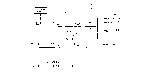
FIG. 1 is a schematic diagram of one preferred
embodiment of the position location system 10 of the
invention. The system 10 includes a plurality of base
stations 12 labelled 12a-12i arranged in a repeating
square pattern in a region 14. In one preferred
embodiment, adjacent base stations 12 are separated by a
distance of, for example, between 0.1 and 10 miles, as
in the.case in which the invention is applied to a
cellular telephone system. It will be understood that
CA 02240628 1998-06-15
WO 97/22888 PCT/US96/19528
-9-
the system of the invention could include more or less
than the nine base stations 12a-12i shown in FIG. 1
depending on the extent of the area to be covered. Only
' nine base stations 12 are shown in FIG. 1 to simplify
the description of the invention.
' An object or person 18 whose position is to be
determined by the system 10 of the invention is located
within the region 14 among the base stations 12. A
portable unit 20 of the invention is located at the
object or person 18. The portable unit 20 can be
carried by the person 18, for example, as a portable
pager unit would be carried, or it can be worn on the
user's wrist. The portable unit can also be built into
clothing, such as a belt, shoe, etc.
When the location of the object or person 18 is to
be determined, the portable unit 20 transmits a locating
signal in all directions into the region 14. The
locating signal can be a pair of single-frequency tones
transmitted one at a time in succession or
simultaneously. The locating signal is received by
several of the base stations 12 which generate
representative signals indicative of various attributes
of the locating signal as received at the base stations.
The representative signal generated by each base station
preferably contains information related to the amplitude
and phase of each tone and time of measurement of the
locating signal as it is received at that particular
base station.
Preferably, the four base stations 12b, 12c, 12e
and 12f surrounding the portable unit 20 and object 18
generate the representative signals and forward them via
a modem over a cable network 24 to a control station 22.
Alternatively, the base stations 12 can transfer the
representative signals to the control station 22 via an
RF link. The control station 22 receives all of the
representative signals from all of the base stations 12.
A processor 26 and an associated memory 28 process the
CA 02240628 1998-06-15
WO 97/22888 PCT/US9b/i952S
-10-
representative signals as described below in detail to
determine the actual location of the object 18 and
portable unit 20.
The embodiment of the system 10 shown in FIG. 1 '
also includes a reference station 16 which synchronizes
the base stations Z2 to ensure accurate timing of '
measurements. The reference station 16 preferably
transmits a continuous tone to the base stations 12
which can be interrupted or modulated periodically to
reset the clocks in the base stations 12. The tone is
at a different frequency than those of the locating
signal tones such that interference is avoided.
The position location system 10 of the invention
implements position location in one of multiple modes.
In one mode, the location process is initiated by the
control station 22. A control signal or "probe" is
transmitted by RF link from the control station 22 to
the portable unit 20 to command the portable unit 20 to
transmit the locating signals. The probe is also
received by the base stations 12 to ready them to
receive the locating signal from the portable unit 20.
In another mode, position location can be
implemented by the person 18 at the portable unit 20.
The person presses a button on the portable unit which
causes a modulated alert command signal to be
transmitted by RF link from the portable unit 20 to base
stations 12 and/or the control station 22. The
modulated alert command signal can also be modulated
with information such as portable unit ID and sensor
data regarding the condition of the person 18. The
method of modulation may be frequency shift keying
(FSK), binary phase shift keying (BPSK), quadrature
phase shift keying (QPSK) or other multiple phase shift
keying. When the control station 22 receives the
modulated alert command from the portable unit, it
generates a probe signal and transmits it back to the
porta3~le unit 20 to command the portable unit 20 to
CA 02240628 1998-06-15
WO 97/Z2888 PCT/US96/19528
-11-
transmit the locating signals to begin position
location. This return request from the control station
22 can also serve as confirmation to the user 18 at the
portable unit 20 that the alert from the portable unit
20 was received by the control station 22.
' The individual subsystems of the position location
system 10 will now be described in detail. FIG. 2 is a
schematic block diagram of one embodiment of the
portable unit 20 of the present invention. The portable
unit 20 includes an antenna 30 coupled to a dual-
position transmit/receive switch 32. In a first
position as shown in the drawing, the transmit/receive
switch 32 couples the antenna 30 to a receiving module
34 which receives signals from the control station 22.
The receiving module 34 can be implemented in a variety
of ways, including the use of a commercial pager.
Alternatively, the receiving module 34 can be
implemented in custom dedicated circuitry. In the case
where the receiving module 34 is a commercial pager, an
additional antenna for transmission is added, and the
transmit/receive switch 32 is eliminated. The antenna
would serve as a dedicated receive antenna and would
be connected directly to the receiving module 34.
When the receiving module 34 determines that a
25 probe signal has been received, it begins the position
location process by issuing a start command to a
transmission sequencer microprocessor/microcontroller 36
and activating a sleep mode control signal which brings
the unit out of sleep mode and into a transmit mode by
30 changing the position of transmit/receive switch 32.
The microprocessor/microcontroller 36 operates to set up
transmission of the locating signals to the base
stations by controlling a frequency synthesizer circuit
45. The processor/controller 36, operating from a 10
kHz reference 38, outputs a voltage controlled
oscillator (VCO) divisor signal to the VCO divider 40 of
the synthesizer circuitry which, in combination with the
CA 02240628 1998-06-15
WO 97/22888 PCT/US96/19528
-12-
kHz reference signal, generates a signal at the
frequency of the first locating signal tone. The signal
is passed through the phase and frequency detector 42
whose output is applied to a loop filter 44. The loop
5 filter 44 passes a control signal to the VCO 46 to set
the frequency of the VCO's output. '
The VCO output is applied to the input of a
splitter 48. One output of the splitter 48 is applied
back to the VCO divider 40. The other output is applied
10 to an input of a BPSK modulator 50. The modulator 50
modulates the output tone. The tone waveform is
primarily designed to identify the location of the
portable unit 20, but it can also be modulated by the
BPSK modulator 50 to transmit any additional data that
I5 may be preprogrammed or requested, such as
identification and/or status of the person or object 18
at the portable unit 20 or any sensor data which may be
available at the portable unit 20. Such sensor data at
the sensor inputs may include measurements reporting on
the vital functions of a person being monitored,
environmental data in the vicinity of the object, etc.
After the VCO divisor signal is applied by the
processor/controller 36, the synthesizer circuitry 45 is
allowed to settle. After the settling time, the
transmit or TX switch 52 is closed or keyed down to
transmit the first locating signal tone. The signal
from the modulator 50 is applied through the switch 52
to a power amplifier 54. The transmit/receive switch 32
is switched to the transmit position such that the
output of the power amplifier 54 is applied to the
antenna 30 to transmit the first locating signal tone to
the base stations.
After transmission of the first tone is completed,
the processor controller 36 outputs the VCO divisor ,
signal for the frequency of the second tone. The above
process is repeated to transmit the second locating
signal tone to the base stations 12. In one embodiment,
CA 02240628 1998-06-15
WO 97/22888 PCT/US96/19528
-13-
the two tones are 20 kHz apart at a frequency of 100 MHz
with a total transmitted power of 100 mW. In this
embodiment, the timing reference signal is at a
' frequency at the midpoint between the frequencies of the
two locating signal tones.
' FIG. 3 is a schematic block diagram of an
alternative preferred embodiment of a portable unit 120
in accordance with the present invention. In the
alternative embodiment of FIG. 3, the settling
requirement of the embodiment of FIG. 2 is eliminated by
the use of two frequency synthesizing circuits 106 and
108 instead of the single synthesizer circuit 45 of the
embodiment of FIG. 2. In FIG. 3, the
microprocessor/microcontroller 136 sends two different
VCO divisors, one to each synthesizer circuit 106 and
108. The VCO 107 of circuit 108 generates the frequency
of the first tone, and the VCO 109 of circuit 106
generates the second frequency tone. A switch 150 is
used to select the tone signal to be forwarded to the
transmission circuitry 52 and 54. In this embodiment,
frequency shift keyed tFSK) modulation is used to
modulate sensor data. As in the previously described
embodiment, the microprocessor/microcontroller 136
controls a sleep mode of the transmission circuitry via
a sleep mode control output. When the receiving module
34 indicates a probe has been received to implement
position location, the sleep mode control signal becomes
active to change the state of transmission circuitry
from sleep mode to transmit mode.
FIG. 4 is a schematic flow diagram illustrating the
operational flow of the portable unit of the present
invention. As shown in step 60, before activation, the
portable unit waits in listen mode to receive a command
to implement the position location process. The command
can come from a probe command transmitted by the control
center or it can be implemented by the user by pressing.
a button on the portable unit.
CA 02240628 1998-06-15
WO 97/22888 PCT/US96/I9528
-14-
Decision step 62 controls the listen mode. Until a
probe is received or a button is pressed, the portable
unit stays in listen mode. When a probe is received or
a button is pressed, flow travels along the "Y" (yes)
branch out of decision step 62 to step 64. In step 64,
the transmitter is keyed on. Depending upon the
decision in step 66, either the locator tones are
transmitted or an alert tone with object identification
are transmitted by the portable unit. As shown in step
68, if probe was received, then the locator signal tones
are transmitted to the base stations. On the other
hand, if the user pressed a button to implement position
location, then, as shown in step 70, an alert tone with
user ID is transmitted to the base stations. As shown
in decision step 72 and step ?4, if data is available
for relaying to the control station, then the signal is
modulated with sensor data. If no data is available,
then the signal is transmitted without data modulation.
After the signals are transmitted, as shown in step 76,
the transmitter is keyed off, and the portable unit
returns to the listen mode in step 60.
FIG. 5 is a schematic top-level block diagram of
one embodiment of a base station 12 in accordance with
the present invention. As described above, each base
station 12 is capable of receiving the signals from the
portable unit 20 as well as from the reference station
16 (see FIG. 1). Each base station 12 preferably
includes at least two antennas 208 and 210 spaced from
each other by a distance between a quarter wavelength
and several wavelengths. Optionally, another antenna
vertically above or below the two or more antennas 208,
210 also spaced by a distance of between a quarter -
wavelength and several wavelengths can be used where
elevation is also being estimated. For the purposes of
the following description, it is assumed that a spacing
of one wavelength is used. It will be understood that
CA 02240628 1998-06-15
WO 97/22888 PCT/US96/19528
-15-
the selected distance is used for illustration only and
is not intended as a limitation.
The antennas 208, 210 are able to receive signals
from any orientation of a linearly polarized transmit
antenna 30 of a portable unit 20. Accordingly, the
polarization of the base station antennas 208, 210 may
be circular, resulting in a 3dB loss, but capable of
receiving any linear polarization. Alternatively,
either dual polarization receivers may be used at the
base stations 12, or different polarizations can be used
at different base stations 12.
Each antenna 208, 210 is coupled to a receiver 212,
214, respectively. If necessary, at least one of the
receivers 212, 214 separates the timing synchronization
tone transmitted by the reference station 16 from the
locating tones transmitted by the portable unit 20.
The base station 12 also includes a local signal
generator 216 which locks onto the received reference
station signal or to a GPS signal and generates two
internal base station tones at the same nominal
frequencies as the locating tones transmitted by the
portable unit 20. The signal generator 216 also
supplies a local clock which counts cycles of the
reference station 16 or GPS tone since the last reset.
This assures that all base station clocks can be
synchronized to the same time referenced to the control
station 22.
The base stations also include preferably two
correlation receivers 218, 220, each of which is coupled
to a receiver 212, 214, respectively. Each correlation
receiver 218, 220 measures the phase and amplitude of
the two tones received from a portable unit 20 relative
to the corresponding two base station tones generated by
. the local signal generator 216.
The outputs from the correlation receiver 218, 220
are complex phasors optionally offset in time and
frequency as discussed below. Such outputs may be
CA 02240628 1998-06-15
WO 97/22888 PCT/US96/19528
-16-
provided in one of at least two ways. The first is by
taking the offset measurement at a prearranged time
coordinated by the control station 22, so that all base
stations 12 take a measurement at the same time. The '
other is to take autonomous measurements which can be
done whenever the correlation receiver 218, 220 detects '
the two locating tones from the portable unit as
sufficiently high receive levels. In this second case,
the correlation receiver 218, 220 records the time of
the measurement and also measures any frequency
difference between the tones received from the portable
units and the tones generated by the local signal
generator 216.
A message receiver 222 in the base station 12 can
receive the two or more modulated locating tones from
the portable unit as described above. The method and
modulation can be frequency shift keying (FSK) or, if
higher data rates.are desired, phase shift keying. A
message transmitted by a portable unit 20 may precede or
follow its position locating tones. For user-generated
alerts however, a modulated alert command may be
received by a base station 12 at any time. Such a
message is relayed to the control station 22 which then
initiates a request for a normal position location
transmission from the portable unit 20.
The outputs of the correlation receivers 218, 220
and the message receiver 222 are applied to a controller
and modem 224. The controller formats message and
signal data for transmission to the control station 22.
In one preferred embodiment, the formatted data is
transmitted by a standard telephone modem.
Alternatively, a dedicated RF link can be used. The
controller and modem 224 also serves the function of
receiving at the base station 12 control and timing data
such as time and identity of the probes from the control
station 22.
CA 02240628 1998-06-15
WO 97!22888 PCT/L1S96/19528
-17-
FIG. 6 is a detailed schematic block diagram which
shows details of the base station 12 of the present
invention not shown in the top-level block diagram of
FIG. 5. For purposes of the description, it is assumed
that two single-frequency tones are transmitted in
' succession from the portable unit 20. The frequencies
of the first and second tones are 100.01 MHz and 100.03
MHz, respectively. The first tone is transmitted for
100 msec and then, following a wait period of 50 msec,
the second tone is transmitted for 100 msec.
The received signals at antennas 208 and 210 are
applied to down converters 250 and 252, respectively.
The local oscillator 254 applies a 100 MHz signal to
each down converter such that when the antennas 208, 210
receive the first tone, the down converters 250 and 252
output a 10 kHz tone, and when the antennas 208, 210
receive the second tone, the down converters 250, 252
output a 30 kHz tone. The tones are digitized at A/D
converters 255 and 256.
The digitized tone data is applied to correlators
258, 260, 262 and 264. As described above in connection
with FIG. 5, the correlators form a portion of the
correlation receiver 218, 220 for each receiver channel
in the base station 12. The correlators 258, 260, 262,
264 operate synchronously at all base stations 12.
Synchronization can be obtained through the transmission
of a reference signal by the reference station 16 (see
FIG. 1), or the use of several other available sources
including GPS-based time references. This time
synchronization is indicated by the time base 266 in
FIG. 6. The time base 266 provides a timing signal to a
reference tone generator 268 which generates the
reference tones applied with the received tones to the
correlators. The correlated waveforms at the output of
the correlators are complex waveforms which are
synchronized with the time reference. The reference
tones are stored or generated digitally.
CA 02240628 1998-06-15
WO 97/22888 PCT/LTS96/19528
-18-
In the absence of frequency offsets, the
correlators can estimate the phase and magnitude of the
signals by integrating the correlator output aver a
fixed period of time, nominally the full 100 msec. In
order to obtain the best phase estimates, the 100-msec
integration should slide to obtain the best alignment
with the incoming signal. This is preferably done by
resetting the integrators 270 frequently, for example,
at a 10 ,sec interval while a running sum of correlator
output values is kept in the computer. By summing the
sequential correlator outputs over different time
intervals, the waveform magnitude and phase of the
signal during the interval in which the peak was
generated can be obtained from the I and Q values.
The timing of the integrators 270 is provided by an
integrate and dump timing circuit 272 which provides
control signals to the integrators 270. The integrate
and dump circuitry 272 also provides a control signal to
time tag circuitry 274. The time tag circuitry 274
forwards time data from the time base 266 to the
computer as signal I and Q data is dumped to the
controller and modem 224. The time tag is forwarded to
the control station 22 along with the pertinent
integrator data to identify the time particular signal
data was received and is used in subsequent position
location calculations.
Because the integration process is carried out over
a significant period of time, frequency offsets should
be taken into account. Conventional techniques, such as
adjusting a local oscillator using information derived
from the incoming signal, are to be avoided, since the
signal-to-noise ratio may be poor, and it is desirable
to minimize the duration of the transmission and to
minimize repeat transmissions.
One solution to this is to provide a bank of
correlators, each at a slightly different frequency, or
to sample the correlator output at a high rate and
CA 02240628 1998-06-15
WO 97/22888 PCT/LTS96/19528
-19-
subject the sampled output to Fourier analysis. The
number of correlators in the bank or the rate at which
the correlator output is to be sampled is determined by
' (1) the maximum frequency offset, which is dominated by
motion and the stability of portable unit crystal, and
' (2) the required integration period. In the 100 MHz
case, frequency offsets due to crystal tolerance, aging
and temperature effects can be as high as ~ 2,000 Hz.
If the correlator is applying a 10 kHz reference tone,
then the output of the correlators would be quadrature
tones anywhere from DC to 2000 Hz, instead of simply DC
values. In order to extract the needed information
without knowledge of the frequency offset or time of
arrival of the signal, the correlator output needs to be
sampled at least at the Nyquist rate, i.e., 4,000 Hz.
This requirement leads to the implementation of
FIG. 7. The embodiment depicted in FIG. 7 is a
variation on that shown in FIG. 6. In the embodiment of
FIG. 7, each of the I and Q correlator outputs is
applied to a low pass filter 370 whose outputs are then
fed to an FFT engine 310. If the signal is sampled at
10 kHz and 100-point transforms are executed, the window
of integration in the FFT is 10 msec, so ten successive
FFTs would span the received tone. To reduce the small
potential degradation in this process, which is due to
non-optimal use of the signal energy, overlapped FFTs
could be used.
There are other options which can be used to
process the digitized samples, including other transform
types. Also, the correlators can be eliminated
altogether, and all processing can then be done in the
FFT. Due to the low sample rates, it is possible to
make multiple passes with the sampled data in real time.
FIG. 8 is a schematic diagram illustrating four
base stations 12a, 12b, 12d and 12e arranged in the
preferred square configuration. The diagram illustrates
one method of orienting the base stations 12 with
CA 02240628 1998-06-15
WO 97/22888 PCT/US96/19528
-20-
respect to each other such that the antennas 208, 210 on
each base station are oriented relative to each other to
optimize the accuracy of the position location process
of the invention. Each pair of antennas 208, 210 on a -
particular base station 12 defines an antenna axis 209
which extends through the center of both antennas 208,
210. In the preferred configuration shown in FIG. 8,
the antenna axes of horizontally or vertically adjacent
base stations 12 are orthogonal to each other. This
l0 improves the ability of the antennas 208, 210, their
associated receivers and other circuitry to accurately
determine the direction to the portable unit 20.
FIG. 9 is a schematic flow diagram illustrating the
operational flow of a base station in accordance with
the present invention. As shown in step 300, the base
station normally operates in an alert listen mode in
which it waits for an interrupt from the control station
22. As shown in the "N" (no) branch of decision step
302, the flow waits for the interrupt from the control
station 22. At the same time, the base station is also
waiting for a user-implemented alert in which the user
presses a button on a portable unit 20 to implement the
position location process. If neither an interrupt from
the control station nor an alert from the user is
received, then the base station waits in the alert
listen mode. If an alert is detected, the flow proceeds
to step 306 in which the alert signal transmitted by
the portable unit 20 is detected and decoded to
determine the ID of the portable unit 20. In decision
step 308, the ID is examined to determine if it is
valid. If it is not, flow returns to the alert listen
mode at step 300. If the ID is valid, an alert message
is sent to the control station 22 in step 310 and flow
then returns to the alert listen mode to wait for the
control station 22 to initiate the position location
process.
CA 02240628 1998-06-15
WO 97/22888 PCT/iJS96/19528
-21-
When an interrupt is received from the control
station 22, flow continues to decision step 312 where it
is determined what type of interrupt was issued. If a
system interrupt such as a maintenance/calibration
request was issued, the request is processed in step
314, and flow returns to the alert listen mode at step
300. If a cellular system location request was made,
the base station enters cellular waveform mode at step
316. In step 318, the base station samples signals from
the cellular device that is to be located and sends
sampled data to the control station 22. Flow then
returns to the alert listen mode at step 300 while the
control station performs the position location process.
If the determination made in step 312 is that a
portable unit is to be located, the base station enters
a probe listen mode in step 320. Upon entering the
probe listen mode, the base station starts a specified
prescribed time-out period. If a portable unit
transmission is detected in step 322, it is examined in
decision step 324 to determine if it is a valid signal
before the time-out period has expired. If not, a "no
response" signal is transferred to the control station
at step 326, and flow returns to the alert listen mode
at step 300. If a valid signal is received from a
portable unit within the time-out period, the phasor
data at all antennas is measured, and the signal data is
sent to the control station 22 at step 328. Flow then
returns once again to the alert listen mode in step 300.
FIG. 10 is a schematic flow diagram of the
operational flow of the control station 22 in accordance
with the present invention. The control station 22 is
_ capable of receiving the outputs of the base station
correlation and message receivers via each base
station's controller and modem through its connection to
an appropriate local network or through an RF link. The
outputs of the-base station are used at the control
station 22 to compute the estimated location of the
CA 02240628 1998-06-15
WO 97/22888 PCT/US96/19528
-22-
portable unit 20. The control station 22 also initiates
requests for a particular portable unit 20 to transmit
its locating tones. The control station 22 also accepts
requests from users carrying specific portable units 20
to locate themselves or such requests from groups of
portable units 20. The control station 22 can also tell
the appropriate base station when, and on what channel,
to look for a cellular transmission. The control
station 22 can also initiate search procedures to locate
objects in the field, as appropriate for the
application. The control station 22 in one grid block
or geographic area can also be capable of communicating
with other control stations serving other grid locks or
geographic areas and in other networks of base stations,
thus being capable of coordinating wide area searches.
FIG. 10 is a top-level flow diagram illustrating
the flow of the control station interrupt loop in
accordance with one embodiment of the invention. The
loop is entered through one of four branches 401, 403,
405,'407, depending upon how the interrupt was
initiated. If a portable unit location request was
received as indicated at step 402, branch 401 is
entered. A control station transmitter is selected to
transmit the probe command in step 404, and the probe is
transmitted in step 406. Finally, in step 408, a
message is transmitted to all base stations within the
probe range informing them that a probe has been
transmitted. In one preferred embodiment, the control
station 22 generates and maintains a database of
location searches in order to provide data for off-line
reports and billing. In step 410, the database is
updated to include the current search, and flow returns
to the top of the interrupt loop at box 411.
If a cellular location request is implemented as ,
shown in box 412, the flow enters through branch 403.
The ceiiular frequency is determined at step 414 and in
CA 02240628 1998-06-15
WO 97/22888 PCT/US96/19528
-23-
step 416, a message is sent to all base stations in the
probe range.
If an alert is relayed by a base station from a
portable unit as shown in step 418, flow enters the
interrupt on branch 405. A portable unit location
request is initiated at step 420. The database of
location searches is updated in step 410, and the flow
then continues to step 402 where a normal portable unit
location request is implemented.
Branch 407 of the interrupt loop is entered when
the control station 22 receives location data from the
base stations as indicated in step 422. As shown in
decision step 424, if portable unit data is received,
then the control station performs portable unit location
processing as indicated at step 426. If cellular data
is received from the base stations, then cellular
processing is performed as indicated at step 428. Once
again, after the processing is complete, at step 410,
the location search database is updated, and flow
returns to the top of the interrupt loop at step 411.
FIG. 11 is a flow diagram showing the steps of
cellular unit processing indicated in step 428 of FIG.
10. Upon entering the processing procedure 428, raw
data is calibrated at step 430. At decision step 432,
the process determines whether more base station data is
to be received. If so, the flow returns to the main
control station interrupt loop shown in FIG. 10 to await
more base station data. If all of the data has been
received, then flow passes to decision step 434 in which
it is determined whether enough base stations have
reported data to permit a position location
determination. If not, a report is made to the user or
authorities in step 437, and flow returns to the main
interrupt loop. if enough stations have reported, then
the stations whose data is to be used in the position
location determination are selected in step 436. The
location is computed in step 438 using triangulation.
CA 02240628 1998-06-15
WO 97/22888 PCT/US96/19528
-24-
An optional tracking filter to refine the location
computation can also be used. In step 440, the location
is reported to the user and/or authorities, and flow
then returns to the main interrupt loop depicted in -
FIG. 10.
FIG. 12 is a flow diagram showing the details of '
portable unit processing indicated in step 426 of FIG.
10. At the beginning of portable unit processing, raw
data from the base stations is calibrated in step 450.
Next, in decision step 452, the process determines
whether more base station data is to be received. If
so, flow returns to the main interrupt loop to await the
additional base station data. If no more base station
data is expected, then flow proceeds to decision step
454 where a determination is made as to whether enough
base stations have reported data to permit a position
location determination to be made. If not, flow
proceeds to decision step 456 where it is decided
whether to initiate another attempt at position
location. If not, a report is made to the user and/or
authorities at step 458, and flow then returns to the
main interrupt loop. If it is decided to try again,
then a new portable unit probe signal is issued in step
460, and flow once again returns to the main interrupt
loop to wait for base station data.
If the decision in step 454 is that enough base
stations have reported data, then the stations used for
the position location determination are selected in step
462. The initial rough location estimate has been
determined in step 462. Next, in step 464, the location
of the portable unit is computed directly using the
ambiguity function A(x,y) (in the case of two-
dimensional position location) as described below in
detail. In step 466, the location is reported to the
user and/or authorities, and flow then returns to the
main interrupt loop.
CA 02240628 1998-06-15
WO 97/22888 PCT/US96/19528
-25-
As described above, in step 464 of the portable
unit processing flow shown in FIG. 12, the location of
the object 18 and portable unit 20 is computed directly
from base station data using a two-dimensional ambiguity
function A(x,y). That computation will now be described
- in detail.
When the control station 22 receives the complex
phasors indicative of the locating tone antenna signals
from the base stations, it computes the position of the
portable unit 20. The following description assumes two
antennas at each base station 12 and two received
locating tones at each antenna at the radial frequencies
ml and w2. Let there be K base stations 12 with usable
signals. Each base station 12 has two antennas 208,
210, referred to herein as antenna 1 and antenna 2,
respectively, and measures four complex phasors, one for
each of the two tones and the two antennas. We
introduce the notation rk~(t) to denote the received
signal at base station #k, antenna #m, and tone #n and
define
r~(t) = a~sin(c~n(t - T~,, - tfl) ) + n~(t) , (1)
where ak~ is signal amplitude, nk~(t) the additive
noise, to the unknown time of transmission, and T~ the
delay. The delay does not depend on the frequency, only
on the distance from the object 18 and portable unit 20
to the particular station k and its antenna m.
We introduce the complex phasor rk~ corresponding
to rk~(t)
ti+T
r~ = Z, ~ a~e~'~atrxr"r, ( t) dt. (2 )
J
where the known period of integration T includes a
section of the received signal, and begins at time t1,
CA 02240628 1998-06-15
WO 97/22888 PCT/US96/19528
-26-
and j is the imaginary unit. Carrying out the
integration, this is equal to
rlcmn - akmne7~n ( T~+to) + ~7xmn (3 )
in which r~k~ is the Gaussian noise component of the
phasor rk~. Thus, each base station k, with two
antennas and using two frequencies, typically provides
four complex phasors. For example, for frequencies c.~l
and cot and antennas 1 and 2, we have the following four
phasor measurements:
measurement rgii at site k, at its antenna 1 and at
radial frequency c.~l,
measurement rki2 at site k, at its antenna 1 and at
radial frequency cot,
measurement rk2i at site k, at its antenna 2 and at
radial frequency coi,
measurement rk22 at site k, at its antenna 2 and at
radial frequency cat .
The complex phasors are next corrected for frequency
offsets in the transmission and far timing offsets
between the base stations.
Before describing the computation of the invention,
it is instructive to consider some simplified cases
which can be likened to direction finding (DF) and
pseudo-ranging (PR) or time difference of arrival (TDOA)
techniques. Using the notation adopted above, the
direction of arrival of the signal can be derived. At
one frequency col only, at a particular base station k,
there is essentially no time offset between its two -
antennas located in close proximity to each other; there
is only a phase difference due to the receiver antenna
spacing, i.e., the distance separating antenna #1 from
antenna #2, which we shall denote by d. Thus,
CA 02240628 1998-06-15
WO 97!22888 PCT/US96/19528
-27-
rkll - aklle~~i (T kI + t~, ~ T~kl1 ~ (4)
rk2i = ak21e~~1~Tk2 + t~? + ~lk2i% (5)
and since the phase difference for a signal arriving at
an angle 8 from boresight due to that distance is equal
to the phase difference of the phasors, we have
2~rr (d12/~Z) sing = col ('rk2 - Tk1) ~ (6)
where d!2 is the distance between antenna #1 and antenna
#2, and ~1=2~c/c~l is the wavelength at the frequency tail.
From this relationship, it follows that an estimate of
the phase difference between the signals at a pair of
antennas at any base station 12 can lead to the
determination of the angle B at that base station to the
object, and hence the determination of direction.
Given the knowledge of base station locations and
the direction from any two base stations 12 to the
object 18, the object's location can be determined by
triangulation. Given the direction from several pairs
of base stations, the location can be further refined.
Such an approach relies on directional estimates, and
this method of obtaining direction described thus far is
similar to conventional direction finding.
The other approach whose description will help
clarify the description of the present invention is the
PR pseudo-ranging (or Time-Difference-of-Arrival)
method. This method involves estimation of phase
differences of the phasors to establish the time-
differences-of arrival at any pair of base stations. We
begin with the simplest example of our transmitted
signal structure, whereby the portable unit 20 transmits
CA 02240628 1998-06-15
WO 97/22888 PCT/US96119528
-28-
tones at two different radial frequencies cal and cue, so
that there is a known frequency offset
i2 . ma _ cal . ( 7 )
Thus, the phasors at, for example, the antenna #1, at
the base station #k, at the two different frequencies,
are:
rkll -' ~kl2eJ~1'Tkl + to) ~ ~k11 ~ (8)
rkl2 - akl2e'~a (T k1 + to) + ~k12 - cZkl2eJ (t~l+f2) (rg1 + to) + ~k12(9)
We assume that signal strength at the two frequencies is
approximately the same, akll = axle, because of the small
frequency offset S2. Hence the phase difference at
antenna #1 at station k between signals at the two
frequencies is
~2 ~Tk1 + t0) W1 ~Tk1 + t0) - S2 ~T7z1 ~ t0) ' (lfl)
Similarly, for a specific base station #l, the same
phase difference at its antenna #1 becomes
~2 ~T11 + t0) ~1 (T11 + ~0) - ~2 (TI1 + t0~ ~11)
Therefore, the phase differences at the two transmitted
frequencies at this pair of base stations becomes
S2(Tkl + t0~ ' S2~T11 + t0) = SZtTkl - t11) . (12)
Since the locus of all the points with the same time '
difference from #k and #1 is a hyperbola, once the time
difference Tkl - T11 is estimated, the hyperbola on which
CA 02240628 1998-06-15
WO 97/22888 PCT/US96/19528
-29-
the signal emitting object 18 must be located becomes
known. Different pairs of base stations generate a
multiplicity of such hyperbolae; the area where they
intersect defines the estimated region of location of
the object_ This method of measuring time differences
~ of arrival outlined above is, in effect, the standard
TDOA method for a two tone signal structure.
With this background, we next describe the approach
used to identify the most probable location of the
object 18 in the preferred version of the present
invention. While our approach is different than either
DF and TDOA, the prior discussion of these other methods
in our notation can be helpful in evidencing that our
approach combines angle of arrival and TDOA data onto an
optimized estimate of object position. The estimated
position of the object is derived by selecting as the
function to maximize that function which will minimize
the joint probability of error with respect to all the
measurements. In one preferred embodiment, we assume
that errors are induced by Gaussian noise at each
receiver.
In the example of two antennas 1 and 2 and two
frequencies 1 and 2, and given the coordinates of the
true position (x,y), we denote the joint probability of
error, conditional on x,y as:
P~rkmrkla~rk2~~rkaa% k = 1,2,3,4~x,y] . (13)
The four complex phasors received at the base
station k (at antennas 1 and 2, and at frequencies 1 and
2) can be represented by phasors:
rkli - Lak~ exp (J~Pk) ' exp (jm1 (Tki ~' to) ) l ~ ~Ikm (14)
rki2 - yak exP tj~Pk) wexp (j~a (Tki + to) ) 7 ~ ~7kia ti5)
CA 02240628 1998-06-15
WO 97/22888 PCT/US96/19528
-30-
rkal - tak~ exp (.J~Pk) ' exP (jy (Tka + to) ) l + ~7ka1 (16)
r'kaa = fak~ exp (7~Px) ' exP (7~a (Tka + to) ) l + ~)xaa (17) -
where r~g~ represents noise at the base station k, at
antenna m, and at frequency n, and where cpk is an
unknown phase depending only on the base station k.
To maximize the joint conditional Gaussian
probability, specified above, we minimize the mean
square error. The location (x, y) at which this minimum
occurs is taken as the estimate of the object position.
Defining
~k ' a1c exP J~Px~ (18)
we form the log-likelihood function. Ignoring
proportionality constants, it can be seen that the
function in question is given by
~rxm-akexp~jwl (ik1+to) }~2+~.rkl2-akexp~jt~2 (ix1+to) }~a
z z
m on~ m kn +~r -a exp(jw (i +t ) }~ +~r -a exp(jw (z +t ) }~
k21 k 1 k2 0 k22 k 2 k2 0
(I9)
When we carry out the minimization of the mean square
error and ignoring the terms independent of location
(x,y), we find that for K antenna sites, each with two
antennas, and each receiving at two frequencies, we need
to determine those location coordinates (x, y) that
maximize the ambiguity function:
CA 02240628 1998-06-15
WO 97/22888 PCT/US96/19528
-31-
A(x.Y) sR(zl) + ~ Z2 ~ . (20)
where R(.) denotes the real value, and ~.~ the absolute
value of the function in the argument, and where
x
Zl~~ (rkl.7.r~ k2le~ ~J~1 (Tk2 Tk1) ~ +z'kl2z'. k22exP ~~~2 (Tk2 Tkz) ~ )
(21/f'i
and
x rxzir' xsaexp (.J~ik1) +rxa.zr' xz2exp ( j~2'ck2)
+rxzir' xzaexp L.7 ( WZikz'u'~ix1) l trki.zr' xzzexP C.7 ( WZixWWWxa
(22)
in which r'k~, is the complex conjugate of rk~ for
S (m, n = 1, 2 ) , and S2 = c~2 - col .
If the function A(x,y) defined above in equation
(19) is called the ambiguity function, and if it were
plotted in three dimensions against x and y, the optimum
estimate of the true location (x,y) in our process is
the point (x, y) at which this decision function A(x,y)
reaches its maximum value. In the position location
process of the invention, the coordinates (x, y) that
maximize A(x,y) are taken as the most likely object
location. The function A(x,y) may be maximized by
standard techniques such as an iterative search to
converge to the maximum through trial-and-error and
gradient search.
Tn one specific embodiment of the invention, we
find the maximum of the ambiguity function A(x,y) by
converging iteratively to the location (x, y) being
sought. In this embodiment, an initial estimate of
(x, y) can be obtained by triangulation.
CA 02240628 1998-06-15
WO 97/22888 PCT/US96/19528
-32-
In the preferred embodiment of the invention, such
a preliminary estimate of the average location is only
used as the initial value in the process for the
accurate determination of object location. The process
then proceeds to improve on the initial estimate by
performing a further iterative search for the best ,
estimate of the desired location of the maximum of
A(x,y). It is one of the important features of the
invention that such a preliminary estimate, located
somewhere in the space surrounded by all the likely
intersections, can be defined more precisely, and its
accuracy can be greatly improved by defining a composite
function of the difference individual measurements.
A further refinement of the process of the
invention described herein consists of also taking into
account other information of the location signal
returned from the object and received at the several
base stations and at the several frequencies. This is
accomplished by applying weights to the phasors, such as
rkli, rki2~ rk2i~ and rk22 (and their conjugates) , and
allocating a higher weight to those phasors which
display a stronger signal (or less noise), and/or
indicate less multipath perturbation (i.e., less
amplitude modulation). In this manner the potential
location error is further minimized. One optimization
approach used to maximize the ambiguity function A(x,y)
is described as follows:
1. Set (xo,yo) to the initial estimate and the
search grid size h to 100ft (for example).
2. Calculate A(x,y) values at the five points:
A(xo.Yo)
A(xo + h,yo) ,
A ( xo - h, yo ) ,
A (xo, yo t h) and
A (xo, yo - h) .
CA 02240628 1998-06-15
WO 97/22888 PCT/US96/19528
-33-
3. Assuming A(xo + h,yo), and A(xo,yo + h) are the
two largest corner point values, also
calculate A (xo + h, yo + h) .
4. Find the maximum, (X,~), of a parabolic
surface through these six points.
5. If (~c,~) is further than h from (xo,yo) repeat
the process for (xo, yo) - (xo + h, yo + h) ,
adding three new points in that direction.
6. If (~2,y) is less than h from (xo,yo)
use (X, y) as the final estimate.
In general, it is noted from the equations (21) and
(22) defining Z1 and Za, that the search for the maximum
of A(x,y) reduces to a generalized DF method when only
one tone is used and we ignore Z2. If the process of
the invention is followed, such a generalized DF method
can use the same measurements as the conventional DF
method, but combines said measurements in a different
way that includes amplitude information which results in
a better location estimate. Similarly, the process of
the invention can reduce to an optimum generalized PR
method when only one antenna is used at each base
station and Zi is ignored.
Thus, from the foregoing description it will be
seen that one advantage of the position location
approach of the invention is that its use permits the
combining of DF and TDOA methods in a predetermined
numerical fashion based on sound analytical foundations
and the reliance on the common. assumption about Gaussian
characteristics of additive noise. Another advantage of
CA 02240628 1998-06-15
WO 97!22888 PCT/US96/i9528
-34-
the invention is that weak signals, which are less
reliable, receive less weighting. Yet another advantage
is that the effect of signals interfered with by
multipath {which can be detected from envelope
modulation) can be de-emphasized by having them given
less weight, or even eliminated from the computation. ,
In addition, the invention can be readily
generalized further to the combining of measurements at
more than two antennas at a particular base station.
Likewise, when there are more than two transmitted tones
from the object (that are then received at a particular
antenna), we can consider the different pairs of
frequencies and the multiple phasor terms that arise.
Such generalizations are a direct extension of the
process described above using two antennas and two
received tones at each site.
As mentioned above, the system and method of the
invention can also be used to locate position of the
portable unit in three dimensions. This allows the
system to also determine elevation of the portable unit.
The three-dimensional approach can be implemented in at
least two ways. First, the process described above can
first be used to estimate the two-dimensional (x, y)
location. Then, one or more vertical antennas can be
used to estimate the elevation z, again using the two-
dimensional approach. Another preferred method is to
extend the above analysis to three-dimensional
estimation of {x,y,z). In this approach, a three-
dimensional ambiguity function A(x,y,z) is computed from
the complex phasors generated for the received locating
signal at each antenna of the appropriate base stations.
The ambiguity function A{x,y,z) is optimized to generate
an estimate of the position of the portable unit
transmitting the locating signal.
The more general three-dimensional case will now be
described in detail. Assume N tones of the locating
signal and M element receivers at each of the K base
CA 02240628 1998-06-15
WO 97/22888 PCT/US96/19528
-35-
stations. As will be described, the process is simpler
if pairs of tones are used at a time.
The signals at the k'th base station are:
At element #l:
rkll - ak' a?~Px. eJ~l ( Tx~s + toss + ~jkl1 ~
rkln - ak~ e.7~Px. eJ~ntTkls + ~os~ + 'rjkln~
rklN - ak~ eJ~Px. e7~N~Txis '~ tos> + ~kzrr~ ~ T)~ - ~?~ - ~2 - 2No~Z'i
(23)
At element #m:
ak' e~'~x. eJwa ~Txms + tos3 + '~krrrl ~
z, - ak. e.7~x. eJ~n~Txi~s + toss + ~~~~ -
(24)
The log-likelihood function is, maximizing over the
unknown amplitudes and phases and ignoring
proportionality constants,
CA 02240628 1998-06-15
WO 97/22888 PCT/US96/19528
-36-
l~(x,y,z) = loge[r~,k=1...K,m=1, ...M,n=1...N~x,y,z]
K M N
- min ~ ~ ~ ~ rkmn «ke~~n(T~"+to~ I2 (25)
ak. tok=1 m=1 n=I
This can be rewritten as
K r 2 + MN cx 2
l~(x,y,z)~ - min ~ ~ ~ ~ kmn~ ~ ki ~ (26)
ak, tok=I -2~J2 [ YkQ'' k]
where
N M
Yk = ~ ~ rkmne _7~n ( T~+to } .
n=1 m=1
Minimizing over cxk we get
K M N
l~(x,y,z)=-min ~ ~ ~rkmn~2 1 ~Yki2 (27)
to k=1 =1 n=1
Ignoring the terms independent of location (x,y,z) we
want to find the location (x,y,z) which maximizes the
function
K
Ao ( x. Y. z ) ~ max ~ ~ Yk I 2
to k=1
K N M
= max. ( ~ ~ rye ~'~n(T'a" + to} ~2. (28)
to k=I n=1 m=1
In general when N>2 the maximum over to depends on the
assumed location. Thus, for more than two tones we
would need to maximize the four-dimensional function
CA 02240628 1998-06-15
WO 9'7/22888 PCT/US96/19528
-37-
K N M
A(X~Y' z' to) ~ ~ ~ ~ ~ rye ~~n(T~ * t°, ~2' (29)
k=1 n=1 m=1
which could be done with conventional maximization
techniques. However, the solution is simplified if only
two tones are considered at a time, since the
maximization over to can be found analytically:
Ap (X, y. Z) - max. ~ ~ rkmznlr~ km2n2e 3~nzTlan .7 aTlang J to (wal ~n2)
to k n1 na ml ma
7~i ( r~,l T~,a) +
rkml l r km21 a
k ml ma
J~2 t T~Z T~2, +
= maX rkml2 r km22 a
to k ml m2
293e ~ to (mz ~2) ~ ~ ~ r r a ~~1~~1+J~aT ~a
kmll km22
k ml m2
J~1 tTlanl T7an2) +
r~~lr gale
k ml m2
_jtD2 ~Tkml_Tlan2) +
- ~ ~ rkml2 r km22 a
k mi ma
2 ~ r r' a ~°'=T~°"1+7
kmll km22
(30)
In the first two lines the terms correlating the same
antenna elements do not depend on (x,y,z) so we can
maximize
A(x.y,z) _ ~ Zl + ~Z2~,
~2 ) +
_ rkrnlir km2i a
Zl ~ ~ ~ -7w2 (T~1 - T~,a)
k ml ma >m1 r~12 r ~a2 a
CA 02240628 1998-06-15
WO 97/22888 PCT/LTS96/19528
-38-
)(JiTlanl + J(~72T1an2
Z2 - ~ ~ ~ 'rkmll r km22 a ~ ( 31 )
This generalizes the algorithm to two tones, multiple
antennas, and three dimensions. For more than two tones
we add A() as calculated for pairs of tones.
As previously noted, the object to be located
(portable unit) may be a wireless cellular telephone.
In a particular example, the mobile telephone may
conform to the TIA/EIA IS-91 AMPS base to mobile air
interface standard in which frequency modulated baseband
tones are propagated during normal operations. The
frequency modulated tones are a set of discrete tones
symmetrical about the carrier frequency tone with
coherence between pairs of tones at equal and opposite
offsets from the carrier frequency. The AMPS telephones
can be commanded by a controlling base station to blank
(shut off) the voice signal for a 500 msec interval,
during which two baseband tones, the Supervisory Audio
Tone (SAT) and the Signaling Tone (ST) are frequency
modulated onto the carrier. The resulting transmitted
signal consists of five discrete tones, two coherent
pairs and one carrier component. These five tones can
be used by the previously described location system and
method for locating the phone.
For emergency location of the telephone, for
example if a user dials 911, the mobile telephone base
station control equipment can be programmed to command
the location system to locate the phone at a certain
instant and to provide the frequency on which the phone
is transmitting. This can be accomplished by either
automatically, or at the initiation of a base station
operator, through commanding (from the base station)
that the mobile phone transmit the tone waveform with no
overt action required by the caller and no discernible
interruption to the call. During the interval of tone
transmission, the location system will generate
CA 02240628 1998-06-15
WO 97/22888 PCT/US96/19528
-39-
individual correlation phasors for eery received tone at
the different receiving antennas, and the location will
be estimated using one of the methods previously
described.
Tf the call becomes disconnected, a mobile phone
' controller that records the origination of 911 calls can
automatically call back the disconnected mobile phone, .
which, until the re-dial is answered, will emit the same
five tones as part of the normal IS-91 call set up
procedure. During this period, the locating system can
use these tones in the manner previously described, to
determine the location of the phone.
If a known user is to be located but is not engaged
in a call, the normal call setup procedure can be used
to initiate the multiple tone transmission from the
desired phone, and the resulting waveform can be used by
the location system to locate the phone.
While this invention has been particularly shown
and described with references to preferred embodiments
thereof, it will be understood by those skilled in the
art that various changes in form and details may be made
therein without departing from the spirit and scope of
the invention as defined by the appended claims.