Note: Descriptions are shown in the official language in which they were submitted.
CA 02303221 2000-03-10 "~
WO 99/14701 PCT/US97/16551
-1-
NAVIGATION SYSTEM WITH USER DEFINABLE COST VALUES
BACKGROUND OF THE INVENTION
This invention generally relates to navigation or route guidance systems
that can be tailored to a user's particular wishes.
Navigation systems generally provide a recommended route from a
starting point to a desired destination. Generally the starting point and
desired
destination are selected from a large database of roads stored in a mass media
storage, such as a CD ROM, which includes the roads in the area to be
traveled by the user. The navigation system can be located in a personal
computer or can be installed in a vehicle. If the navigation system is
installed
in a vehicle, the starting point is typically the current position of the
vehicle,
which can be input from an associated positioning determining device, such as
a GPS (Global Positioning System) receiver.
The navigation system determines a route from the starting point to the
destination utilizing an algorithm well-known to those in the art and
currently
in use in many navigation systems. Usually there are many potential routes
between the selected starting point and the desired destination. The
navigation
system selects a recommended route based upon certain "cost" values
associated with each segment of road in the road database. These cost values
include the length of the road segment and the estimated time of travel
through
the road segment. The navigation system selects the potential route with the
lowest total cost to be the recommended route. Depending upon the
predetermined algorithm of the navigation system, the navigation system will
recommend the route with the shortest total length, the lowest total time, or
some weighted average of length and time.
The recommended route is then displayed to the user as a map showing
the starting point and desired destination and highlighting the recommended
route. Preferably, if the navigation system is installed in a vehicle, the
CA 02303221 2000-03-10
WO 99/14701 PCT/US97/16551
-2-
navigation system displays the current position of the vehicle and turn-by-
turn
instructions to the driver, guiding the driver to the selected destination.
Some drivers prefer to avoid certain roads that they believe to be
congested or certain areas that they believe to be unsafe. Some drivers may
have a preference or aversion for particular types of roads such as highways
or toll roads. Further, a route which is the shortest distance is sometimes
preferred, while a route which is the lowest total time of travel is preferred
at
other times.
Current navigation systems have several limitations in how they select
a potential route as the recommended mute. The known navigation systems
permit the driver to select one of the following preferences: fastest route;
shortest route; use highways; avoid highways. However, the known systems
do not permit the driver to adjust a weighting factor to be given to these
preferences; nor can the driver adjust a balance between the fastest and
shortest routes. Further, the known navigation systems do not permit the user
to designate selected areas or roads to avoid or to adjust a
preference/aversion
factor of the road or area.
SUMMARY OF THE INVENTION
The present invention provides a navigation system which permits the
user to modify the cost of roads when planning a route. The navigation
system generally includes a database of roads to be traveled by a user. Each
road in the database includes a "cost" for each road segment, such as
estimated
time of travel across that road segment and estimated length of travel across
that road segment. A beginning point relative to the database of roads is
input
from a position determining device, such as a GPS system, or is input by the
user, utilizing a mouse, keyboard or joystick. The user then selects a desired
destination relative to the database of roads. The user selectively adjusts
the
cost for selected road segments or groups of road segments. When the
CA 02303221 2000-03-10
WO 99/14701 PCT/US97/16551
-3-
navigation system determines a route from the selected beginning point to the
desired destination, the navigation system evaluates the cost of the road
segments to be traveled in several potential routes and recommends the
potential route having the lowest total cost.
Because the user can selectively modify the cost of selected road
segments, the user can indicate a preference or avoidance of such roads which
will be considered by the navigation system when planning a route. For
example, if the cost of a road segment is increased, the navigation system is
less likely to recommend a potential route which includes that road segment.
Similarly, if the cost of a selected road segment is decreased, the navigation
system is more likely to recommend a potential route which includes that road
segment.
Adjusting the cost of selected road segments can have many potential
applications. First, by increasing the cost of certain road segments selected
by the user, the user can indicate the road segments that the user desires to
avoid, because the user believes these road segments to be congested or in an
unsafe area. Alternatively, the navigation system can include a data receiving
device which receives information regarding congested road segments and
automatically updates congestion level values associated with each road
segment.
By categorizing each road segment into a road type, such as highway,
toll road, etc. , the user can modify the cost of selected types of roads,
thereby
indicating a preference for highways or toll roads or an aversion to highways
or toll roads. Further, by modifying the estimated time of travel of road
segments differently than the estimated length of travel of road segments, the
user can adjust the preference for a route having a low estimated time of
travel
or a low estimated distance of travel.
CA 02303221 2000-03-10
WO 99/14701 PCT/US97/16551
-4-
BRIEF DESCRIPTION OF THE DRAWINGS
The above, as well as other advantages of the present invention, will
become readily apparent to those skilled in the art from the following
detailed
description of a preferred embodiment when considered in the light of the
accompanying drawings in which:
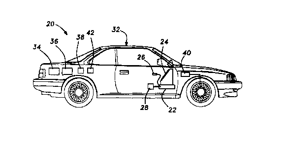
Figure 1 is a schematic of the navigation system of the present
invention installed in a vehicle having a position determining device;
Figure 2 is a flow chart of the navigation system of Figure 1;
Figure 3 is a screen of the display of the navigation system of Figure
1 illustrating a route guidance instruction;
Figure 4 is a flow chart of the Route Planning routine in Figure 2.
DETAILED DESCRIPTION OF A PREFERRED EMBODllVIENT
The navigation system 20 of the present invention is shown
schematically in Figure 1. The navigation system 20 includes a CPU 22
connected to a display 24, such as a high resolution LCD or flat panel
display.
The CPU 22 is also connected to an input device 26, such as a mouse or
keyboard. Alternatively, the display 24 can be a touch screen display. The
navigation system 20 further includes a database 28 connected to the CPU 22.
The database 28 is a mass media storage device, such as a CD ROM which
includes a map of all of the roads in the area to be traveled by the user.
Each
road in the database is divided into road segments, each having an associated
set of cost values, which indicate the "cost" of traveling that road segment.
For example, the cost values include the length of the road segment, the
estimated time to travel the road segment, the type of road (i.e. highway,
secondary road, toll road, one way, etc.), and congestion level.
The navigation system 20 can, but need not, be installed in a vehicle
32. The navigation system 20 can be used in conjunction with position-
determining devices, such as a GPS system 34, a gyroscope 36, a compass 38,
CA 02303221 2000-03-10
WO 99/14701 PCT/US97/16551
-5-
and a wheel speed sensor 40, all connected to the CPU 22 [connections not
shown for simplicity]. Such position determining devices are well known and
are commercially available. Preferably, a combination of these position
determining devices is utilized. The navigation system 20 further includes a
data receiver 42, such as a radio receiver for receiving up-to-date broadcast
information regarding the congestion levels of area road segments.
Congestion-monitoring devices are known and currently used to automatically
monitor the congestion levels of certain road segments, typically near
intersections. Preferably, information regarding congestion from the
congestion-monitoring devices is broadcast to the surrounding area and
received by the data receiver 42. The data receiver 42 sends the congestion
information to the CPU 22, which stores the updated congestion information.
Alternatively, many radio stations broadcast information regarding the
congestion levels of area road segments. This congestion information can be
added manually by the user to the CPU 22.
The operation of the navigation system 20 is shown in Figure 2. For
purposes of illustration, the navigation system 20 of the present invention
will
be described as installed in a vehicle 32 having position determining devices.
At power-up, the navigation system 20 preferably begins in the main menu 50,
which informs the user that he may elect to plan a route 52, edit congested
roads 54, or edit routing criteria 56.
By selecting to edit congested roads in step 54, the user can delete
items from the congested road list in step 96, add items to the congested road
list in step 98, or edit the congestion levels in step 99. If the user elects
to
add items in step 98, the display 24 prompts the user to select a road segment
from a local area, a road segment in another area, or all road segments in an
area. Utilizing the mouse 26, if the user wishes to add all road segments in
an area to the congested road list, the user selects a state in step 100 and a
city
or area in step 102. The user then sets the congestion level in step 103.
Preferably, the congestion level is selected from at least 3 levels and most
preferably 14 levels. Preferably, the lowest congestion level assigns a
CA 02303221 2000-03-10
WO 99/14701 PCT/US97/16551
_(r
congestion value of 1.0, signifying no known congestion. Level 14, the
highest level, would assign a congestion level on the order of 10,000,
indicating an almost absolute avoidance, unless there is no alternate route,
such as if the destination or beginning point is located on that road segment.
Preferably, the congestion value for each level increases approximately by a
factor of 1.7, such that the congestion value is assigned by level 2 is 1.7,
level
3 is 2.89, level 4 is 4.9 and level 5 is 8.35, etc.
If the user elects to add a road segment in the immediate area
surrounding the present vehicle location, the user selects a road in step 108
by
entering the first few letters of the road name and then selecting the road
from
an alphabetized list. If the user elects to add a road in another area, the
user
must first select a state in step 110 and a city or area in step l I2.
After selecting a road in step 108, the user selects a particular road
segment or segments in step 114 such that the congested area includes a road
segment between selected exits, a single exit, a single intersection, the
entire
road within a city, the entire road within an area, etc. If the user has not
selected a road segment which is a one way street, the user can select to edit
the congestion level in a single direction or in both directions in step 116.
The
congestion level is then set in step 103.
If the user elects to delete items from the congested road list in step 96,
a list of all roads, cities, areas, or road segments for which a congestion
level
has been set, is displayed. Utilizing the mouse 26, the user selects an item
or
items to be deleted from the congested road list. The user can utilize this
adjustment to select or not select roads, geographic areas, etc. that the user
wishes to avoid or use for purely personal reasons. The display at step 96
may include the legend "Edit Personal Preference", or a separate election can
be add to the system for personal preference. The user would increase the
congestion value for an area or road that he wishes to avoid. Also, the system
could include a display or "Personal Preference" that can be adjusted and then
used similarly to the congestion value.
CA 02303221 2000-03-10
WO 99/14701 PCT/US97/16551
_'j_
The user can also elect to edit the congestion levels in step 99, in
which case the entire list of roads, road segments, cities, and areas is
displayed. The user selects an item from the list utilizing the mouse 26, and
sets the congestion level for that item in step 103. If the user elects to
edit the routing criteria 56 from the main menu 50, the user can modify the
time/distance factor in step 128 utilizing the mouse 26. Preferably, the user
selects one of at least 7 levels for the time/distance factor. The
time/distance
factor is a value to be multiplied by an estimated time of travel to weight it
for
comparison against an estimated length of travel. The lowest level, level 1,
would preferably have a time/distance factor of zero miles per hour,
indicating
an absolute preference for the route having the lowest estimated time of
travel,
rather than shortest length of travel. The highest level, level 7, would
preferably have a time/distance factor of 1000 miles per hour, indicating an
almost absolute preference for the lowest length of travel route, rather than
the
lowest estimated time of travel route. The middle level, level 4, would
preferably have a time/distance factor of 45 miles per hour, indicating a
medium preference between the route having the lowest estimated time of
travel and the road having the lowest estimated length of travel. The other
levels would have intermediate time/distance factors.
From the routing criteria menu 56, the user can elect to modify the
highway preference /avoidance factor in step 132. The highway
preference/avoidance factor multiplies the cost of any highways in potential
routes. Preferably, the display 24 displays at least 7 levels to the user,
which
can be selected using the mouse 26. The middle level, Ievel 4, would have a
highway preference/avoidance factor of 1.0, indicating no preference or
avoidance of highways. Level 1, avoidance, would preferably have a highway
preference/avoidance factor of 1000, indicating an almost absolute total
avoidance of highways. Level 7, preference, would preferably have a highway
preference/avoidance factor of 0.2, indicating a preference for highways, by
effectively decreasing the cost of highways by a factor of 5. Preferably, the
navigation system 20 further includes the data receiver 42 which receives
CA 02303221 2000-03-10
WO 99/14701 PCT/US97/16551
_g_
information regarding congested road segments in the surrounding area and
sends the congestion information to the CPU 22, where the congestion levels
of the appropriate road segments are updated. Alternatively, or in addition,
the data receiver 42 can be a standard radio which receives local broadcasts
regarding the congestion levels of area road segments, in which case the user
could manually update the congestion levels for the appropriate road segments.
From the routing criteria menu 56, the user can also elect to modify the
toll roads preference/avoidance factor in step 136. Preferably, the display 24
displays to the user at least 7 levels for the toll road preference/avoidance
factor, which can be selected utilizing the mouse 26. The middle level, level
4, would have a toll road preference/avoidance factor of 1.0, indicating no
preference or avoidance of toll roads. Level 1, avoidance, would preferably
have a toll road/avoidance factor of 10, indicating an avoidance of toll roads
so long as the cost is otherwise increased by less than a factor of 10. Level
7, preference, would preferably have a toll road preference/avoidance factor
of .2, indicating a preference for toll roads so long as the cost is not
otherwise
increased by a factor of 5. The remaining levels would have appropriately
scaled intermediate factors.
If the user elects to plan a route 52, the navigation system 20 inputs a
starting point relative to the database 28 in step 157. If the navigation
system
20 includes a position determining devices, the current position of the
vehicle
32 is input as the starting point for the route to be planned. Otherwise the
user selects a starting point utilizing the display 24 and mouse 26.
Preferably
the user types in the first few letters of the name of the road and then
selects
the starting point road from a list of roads. The user then selects an
intersection or address as a beginning point.
The navigation system 20 then inputs the destination. In step 158, the
user selects a destination from the local area surrounding the current vehicle
position or from all areas. If the user wishes to select a destination from a
local area, the user selects a road as the destination to which the route will
be
guided in step 160. Otherwise the user must first select a state in step 162
and
CA 02303221 2000-03-10
WO 99/14701 PCT/US97/16551
-9-
a city or area in step 164. In step 166, the navigation system 20 requests
whether to plan the route to a specific intersection of the selected road in
step
168, a specific address on the selected road in step 170 or the nearest point
on
the selected road in step 172.
In step 176, the navigation system 20 plans a route from the starting
point to the selected destination utilizing the roads in the database 28. The
navigation system 20 evaluates the total cost of a plurality of potential
routes
between the starting point and selected destination. The navigation system 20
selects the potential route from the starting point to the selected
destination
which has the lowest total cost as modified by the user in the Route Planning
routine 176, described more fully below.
If the vehicle 32 is moving when the route planning routine 176 is
completed, the display 24 of the navigation system 20 displays route guidance
information in step 178. Preferably, the navigation system 20 displays "turn-
by-turn" information to the driver, i.e., the display 24 displays a map of the
immediate area showing the present position of the vehicle and the next
maneuver in the recommended route. If the vehicle '~2 is etatinnarv ~t tho
time the route planning routine 176 is complete, the display 24 preferably
displays a list of the road segments in the recommended route in step 180. As
the user scrolls up and down through the road segments in the recommended
route list, a graphical image of the recommended maneuver (i.e., turn right or
turn left) is displayed adjacent the mute list. In step 182, the user can edit
the
route list by selecting one of the segments in the recommended route list. In
step 186, the user adds the selected road segment from the recommended route
list to the congested roads list. In step 190, the user sets the congestion
level
for the selected road segment. Preferably, if the item was not previously on
a congested road list, the congestion value is set to 1.7. If the road segment
was already on the congested road list, the congestion value is multiplied by
1.7 in step 190. If the user edits the route list, the navigation system 20
must
replan the route in step 176, utilizing the new cost values. If the vehicle 32
is moving, the navigation system 20 will then proceed to step 178, where the
CA 02303221 2000-03-10
WO 99/14701 PCT/US97/16551
-10-
display 24 will display turn-by-turn route guidance instructions to the
driver.
As shown in Figure 3 the display 24 preferably displays a map of the
immediate area showing the present position of the vehicle and the next
maneuver in the recommended route.
The Route Planning routine 176 is shown in detail in Figure 4. First,
the CPU 22 determines potential routes from the beginning point to the desired
destination in the road database 28 in step 194. In step 196, the CPU 22
multiplies the cost of each road segment by the congestion level for that road
segment if the congestion level has been set. For example, if one of the road
segments in one of the potential routes from the starting point to the
selected
destination includes a congestion value of 1.7, the length and estimated time
of travel for that road segment are multiplied by 1.7.
In step 198, the CPU 22 multiplies the cost of each road segment which
is a highway by the highway preference/avoidance factor. If the user has
defined a preference/avoidance value for highways, the cost (time and length)
of the highway road segments in the potential routes are multiplied by the
highway preference/avoidance value. If highways are preferred, the highway
preference/avoidance value is less than 1, thereby reducing the length and
estimated time of travel for purposes of estimating the "cost" of travelling
highways. If the highway preference/avoidance value is greater than 1, the
length and estimated time of travel of highway road segments will be
increased, thereby increasing the "cost" of highway road segments.
In step 200, the CPU 22 multiplies the cost of any potential road
segments which are toll roads by the toll road preference/avoidance factor.
Again, a value less than one would reduce the effective cost of travelling
toll
roads, thereby indicating a preference for toll roads. A value greater than
one
would increase the effective cost of toll roads, thereby indicating an
aversion
to toll roads.
In step 202, the CPU 22 selects the potential route which has the lowest
total time cost, after factoring in the afore-mentioned user preferences.
CA 02303221 2000-03-10
WO 99/14701 PCT/US97/16551
-11-
Similarly, in step 204, the CPU 22 selects the potential route which has the
lowest distance cost, after factoring in the afore-mentioned user preferences.
In step 206, the CPU 22 compares the lowest time cost potential route
with the lowest distance cost potential route. The time cost of the lowest
time
cost route is multiplied by the time/distance factor to convert it to a
distance
to be compared to the distance cost in the lowest distance cost potential
route.
In step 208, the CPU 22 selects the route with the lower distance cost,
after converting the time of the lowest time cost route to distance utilizing
the
time/distance factor. For example, at level 1, the time/distance factor would
be set to zero, in which case the lowest time cost potential route would
always
be selected over the lowest distance cost route. At level 4, each hour in the
lowest time cost route would be converted to 45 miles, indicating a medium
balance between the shortest route and the quickest route. At level 7, each
hour in the lowest time cost route would be converted to 1000 miles, which
would effectively ensure that the lowest distance route would have a lower
cost
than the lowest time cost route, indicating a strong preference for the
shortest
route rather than the quickest route.
Preferably, the settings selected by the user are stored and are utilized
when the user plans the next mute to a new destination. Optionally, the
navigation system 20 can reset the congestion levels, highway
preference/avoidance, toll road preference/avoidance and time v cost factor
when the navigation system 20 is turned off, or when the destination is
reached.
In accordance with the provisions of the patent statutes, the present
invention has been described in what is considered to represent its preferred
embodiment. However, it should be noted that the invention can be practiced
otherwise than as specifically illustrated and described without departing
from
its spirit or scope.