Language selection

Search

Patent 2307504 Summary

Third-party information liability

Some of the information on this Web page has been provided by external sources. The Government of Canada is not responsible for the accuracy, reliability or currency of the information supplied by external sources. Users wishing to rely upon this information should consult directly with the source of the information. Content provided by external sources is not subject to official languages, privacy and accessibility requirements.

Claims and Abstract availability

Any discrepancies in the text and image of the Claims and Abstract are due to differing posting times. Text of the Claims and Abstract are posted:

  • At the time the application is open to public inspection;
  • At the time of issue of the patent (grant).
(12) Patent Application: (11) CA 2307504
(54) English Title: ARRANGEMENT AND METHOD FOR LOCATING DATA CARRIERS
(54) French Title: DISPOSITIF ET PROCEDE POUR LOCALISER DES SUPPORTS DE DONNEES
Status: Deemed Abandoned and Beyond the Period of Reinstatement - Pending Response to Notice of Disregarded Communication
Bibliographic Data
(51) International Patent Classification (IPC):
  • G01S 1/00 (2006.01)
  • G08G 1/123 (2006.01)
(72) Inventors :
  • MAASS, HENNING (Germany)
  • FALCK, THOMAS (Germany)
(73) Owners :
  • KONINKLIJKE PHILIPS ELECTRONICS N.V.
(71) Applicants :
  • KONINKLIJKE PHILIPS ELECTRONICS N.V.
(74) Agent: SMART & BIGGAR LP
(74) Associate agent:
(45) Issued:
(86) PCT Filing Date: 1999-08-19
(87) Open to Public Inspection: 2000-03-09
Examination requested: 2004-08-16
Availability of licence: N/A
Dedicated to the Public: N/A
(25) Language of filing: English

Patent Cooperation Treaty (PCT): Yes
(86) PCT Filing Number: PCT/EP1999/006107
(87) International Publication Number: WO 2000013035
(85) National Entry: 2000-04-26

(30) Application Priority Data:
Application No. Country/Territory Date
198 38 902.7 (Germany) 1998-08-27

Abstracts

English Abstract


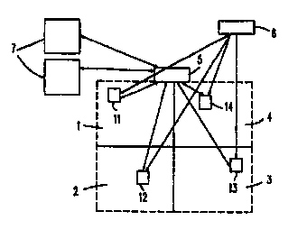
The invention comprises an arrangement with which mobile objects can be
located in particular areas. The mobile objects for locating, e.g., persons or
inanimate objects, are provided with a data carrier which determines the
absolute position using a position-determining system such as e.g., GPS. For
many applications, it is not always necessary to know the absolute position of
the object. Information about the area in which the object is located is
usually sufficient. In order to optimise the exchanging of data between the
application that requires the location of the data carrier and the object
itself, the absolute position of the objects is transmitted to an information
unit when the data carrier is initialised. Said information unit translates
the co-ordinates using a digitised map or a plan divided into areas so that
the object can be allocated to a corresponding area. This data is stored in
the information unit. The boundaries of the area in which the object is
located are transmitted to the data carrier and if the object changes its
position, the data carrier itself can determine whether the object has left an
area. If the current position of the data carrier no longer matches the area
information, the data carrier reports its position to the information unit
again. If an application requests the position of a data carrier, the
information unit transmits the data carrier area information that has been
stored to the application. This results in optimal communications between the
applications and the data carriers. The position of the data carrier can be
established even when the data carrier cannot be reached momentarily.


French Abstract

L'invention concerne un dispositif permettant de localiser des objets mobiles dans des zones déterminées. Les objets mobiles à localiser, par exemple des personnes ou des objets, sont pourvus d'un support de données qui détecte leur position absolue au moyen d'un système de détermination de position, par ex. GPS. Pour de nombreuses applications, il n'est pas toujours nécessaire de connaître la position absolue d'objets. Une information sur la zone, dans laquelle se trouvent les objets, est suffisante dans la plupart des cas. Afin d'optimiser l'échange de données entre l'application, pour laquelle le lieu de situation de l'objet présente un intérêt, et l'objet lui-même, la position absolue de l'objet est transmise à une unité d'information lors de l'initialisation du support de données. Cette unité d'information traduit les coordonnées au moyen d'une carte numérisée ou d'une division en zones, de sorte que l'objet peut être affecté à une zone correspondante. Ces données sont mémorisées dans l'unité d'information. Les limites de la zone dans laquelle se trouve l'objet sont transmises au support de données. Ce dernier peut déterminer lui-même en cas de changement de position si l'objet quitte ou non une zone. Si la position, à un moment donné, du support de données ne coïncide plus avec les informations de zone, le support de données signale de nouveau sa position à l'unité d'information. Si une application demande la position d'un support de données, l'unité d'information transmet à l'application les informations de zone mémorisées du support de données. La communication entre les applications et le support de données est ainsi optimisée. La position du support de données peut être déterminée même si l'on ne peut pas avoir accès momentanément au support de données.

Claims

Note: Claims are shown in the official language in which they were submitted.


7
CLAIMS:
1. A locating system having a position-determining system and at least one
data
carrier including a position sensor, a transmitter and a receiver,
characterized in that area
information is stored in an information unit which is remote from the data
carrier and can be
transmitted to the data carrier and said data carrier transmits its position
to the information
unit only in the case of initialization and a change of area.
2. A locating system as claimed in Claim 1, characterized in that the data
carrier
has a receiver for receiving in particular area boundaries, and a memory for
storing area
boundaries and absolute position data, and a comparator for said data, and the
information
unit compares the position data with the area information and transmits the
boundaries of the
current area to the data carrier.
3. A method of locating an object provided with a data carrier, the data
carrier
receiving position data from a position-determining system, characterized in
that the data
carrier transmits position data to an information unit, which position data is
allocated to an
area in the information unit, and the boundaries of the current area are
transmitted to the data
carrier and upon each movement of the data carrier the current position is
compared with the
boundaries of the current area and the new position data being transmitted to
the information
unit only in the case of a negative result of the comparison of the area
boundaries transmitted
by the information unit with the current position of the mobile data carrier.
4. A method as claimed in Claim 3, characterized in that the position data
transmitted by the mobile data carrier is translated into area data in the
information unit and
the current area in which the data carrier is located is stored in the
information unit.
5. A method as claimed in Claims 3 and 4, characterized in that applications
interrogate the information unit for the location of a data carrier.

Description

Note: Descriptions are shown in the official language in which they were submitted.


CA 02307504 2000-04-26
PHD 98.097
1 12.04.2000
Arrangement and method for locating data Garners.
The invention relates to an arrangement for and method of locating objects
provided with data Garners.
Such methods enable persons or devices to be located in respective areas. For
this purpose, the objects have a portable data carrier which receives position
data from a
positioning system, for example the Global Positioning System (GPS).
US 5,490,079 describes a system for automated toll collection which utilizes
GPS. The system operates with a tag which includes a GPS sensor. When the tag
determines
that it is situated in such an area, it sends a signal to a receiver. The time
of staying in the toll
area is stored in the tag. When the toll fee which is due has been paid at an
authorized point
of payment the amount of toll incurred is cleared. In the case of non-payment
of this toll the
tag is deactivated after a given time. The tag inter alia includes a memory
which stores the
toll areas.
In order to enable a universal use of such a data carrier the size of the data
carrier should be small in relation to the object. On the other hand, such
mobile data carriers
require batteries which must be small but should have a long life.
Often, the absolute position of an object or person is not relevant and for
many
uses it is sufficient when more general area information or the relative
position is available.
It is an object of the invention to provide an arrangement and a method by
which the exchange of data between data carrier and information unit.
This object is achieved by means of the arrangement defined in Claim 1 and
by means of the method defined in Claim 3.
The locating system essentially consists of three components: a position-
determining system, an object provided with a data carrier and an information
unit.
Upon its initialization the data carrier transmits its absolute coordinates,
which
represent its absolute position, to the information unit. The information unit
stores
corresponding areas in electronic maps. The information unit translates the
respective
absolute coordinates of the data Garner into the relative area data. Moreover,
the data of the
area in which the data carrier is currently located is stored. The information
unit transmits the

- PHD 98.097
CA 02307504 2000-04-26
2 12.04.2000
boundaries of the area in which the object is located back to the data
carrier, where this data
is then stored.
Since the object can move within its area, in other areas and also outside the
- area defined by area boundaries, the data carrier requests its absolute
position in definable
distances from the position-determining system. By a comparison of this
absolute position
with the boundaries stored for the area it is determined whether the data
Garner is still within
the respective stored area. As long as this comparison reveals that the object
with the data
carrier is still located in the respective area there is no communication
between the data
carrier and the information unit. Once the data carrier detects that its
absolute coordinates lie
outside the area stored in the carrier it will transmit its new position to
the information unit.
An advantage of this method is that the relative position of the object is
continually available in the information unit for any application for which
the location of the
object is of interest.
This reduces the communication between the data carrier and the information
unit to a minimum.
Since the information unit stores, for example, toll areas or application-
specific areas the data Garner need not be as intricate and expensive. The
stored areas can be
changed any time without modification of the data carrier.
How many time the data carrier requests its absolute position from the
positioning apparatus depends particularly on the required accuracy but also
on the speed
with which the object travels.
Applications, for example locating systems which are interested in the
location
of the object but for which the absolute position is not crucial can at any
time query the
information unit for the instantaneous area where the data carrier is located
via existing
infrastructural networks.
Situations may arise in which the data carrier is briefly out of contact with
the
information unit, for example when infrared or radio networks with incomplete
coverage are
used. The failing contact between the information unit and the object with the
data carrier is
then not a problem because the information unit stores the area or, in general
terms, the
relative position of the object.
The relevant application need not immediately interrogate the individual data
carriers for each query. This simplifies the communication means. In addition,
a plurality of
applications can be provided with area information of the objects without each
individual
application having to communicate with the objects.

PHD 98.097
CA 02307504 2000-04-26
3 12.04.2000
As a result of this reduction of the communication means the batteries and,
consequently, the logic means necessary in the data carrier can be small. On
the one hand,
this extends the operating period of such a data carrier and, on the other
hand, it extends its
fields of use.
Further advantageous embodiments of the invention will be apparent from the
description and the accompanying drawings. In the drawings:
invention,
Figure 1 shows a block diagram of an arrangement in accordance with the
Figure 2 shows the structure of a data carrier in conjunction with the
position-
determining system and the information unit, and
Figure 3 shows a time chart for the components involved.
Figure 1 shows the structure of an arrangement in accordance with the
invention. The information unit 5 monitors for example four areas 1, 2, 3 and
4 in which
objects to be monitored and each having a respective data carrier 1 l, 12, 13
or 14 is located.
The position-determining system 6 transmits the absolute position data to the
data carriers 11
to 14. Said absolution position data is transmitted to the information unit 5
in dependence on
the mode of the data carrier. In turn-on mode of the data carrier the absolute
position data is
transmitted directly to the information unit. The information unit 5 transmits
boundaries of
the respective area in which the data carriers 11-14 are currently located
back to said carriers.
Apart from this, the absolute position data is only transmitted to the
information unit 5 when
these lie outside the stored limits of the current instantaneous area.
Applications 7 for which
the location of the data carriers 11 to 14 is of interest receive the current
area information
from a data bank from the information unit 5. For this purpose the data
carrier need not be
contacted. If applications need to respond under given conditions the
information unit 5
transmits a message to the application when the respective condition occurs.
Figure 2 shows the data carrier 11, which includes a position sensor 20, a
transmitter 21, a receiver 22, a memory 23 and a comparator 24. By means of
the position
sensor 20 the data carrier 11 receives its absolute position data, for example
its absolute
coordinates in a space or the geographical position with a length and width
specification,
from the position-determining system 6. For the position-determining system 6
the Global
Positioning System (GPS) can be used. It is likewise possible to use local
position-
determining systems operating with infrared or radio waves inside buildings.

PHD 98.097
CA 02307504 2000-04-26
4 12.04.2000
The object to be monitored is connected to the data Garner 11. Upon
initialization, for example upon turn-on, the data Garner 11 receives the
absolute position data
from the position -determining system 6 via the position sensor 20. The
position data
received upon initialization are transmitted directly to the information unit
5. The transmitter
21 provided in the data carrier 11 is used for this purpose. It is also
possible to transmit
additionally included information, such as time and identification, to the
information unit 5.
The information unit 5 stores the respective areas in the form of electronic
maps. The
information unit 5 receives the absolute position data of the location of the
object transmitted
by the data carrier 11 during the initialization process. In the information
unit 5 said absolute
position data is assigned to the respective area in which the with the data
Garner 11 is now
located. The information in which area the object with the data carrier is now
located is
stored in a data bank of the information unit 5. The boundaries of the area in
which the object
is located are transmitted back to the data carrier 11. The data carrier 11
receives these
boundaries by means of the receiver 22. The boundaries may be transmitted in
the form of
data of a polygon. The data Garner 11 stores these boundaries in the memory
23.
Depending on the required accuracy the position-determining system 6 is
interrogated for the current absolute position by the data Garner 11 at
appropriate intervals.
Each new position is compared with the boundaries stored in the memory 23 by
the
comparator 24. There is no communication between the data carrier 11 and the
information
unit 5 as long as the object with the data carrier 11 is located in the area
whose boundaries
are stored in the data carrier. The data carrier transmits its absolute
position to the
information unit 5 only when it is located outside the area and this is has
been detected by
comparison with the stored boundaries. The information unit then determines
the data
corresponding to said position data with the aid of the electronic maps stored
in it, stores the
area which the object has entered, and transmits the new boundaries of the
area to the data
carrier 11.
This results in an optimization of the communication between the data carrier
11 and the information unit 5 during the time that the data carrier 11 is
located within an area.
Upon a request to the information unit an application that is interested in
the instantaneous
position of the data carrier receives the position data of the respective area
stored for the
relevant data carrier 11. Thus, it is not necessary for the data Garner 11 to
be constantly
within the receiving range of all possible applications.

PHD 98.097
CA 02307504 2000-04-26
12.04.2000
An information unit thus serves a multitude of data carriers 11. Different
applications can simultaneously access the information unit 5, as a result of
which each
application need not directly contact the respective data carriers.
_ Figure 3 shows diagrammatically the time chart for the communication
5 between the elements of the locating system. The process for the data
carrier is represented at
A, for the information unit at B, for the position-determining system at C,
and for an
application at D. A step (31 ) represents the initialization of the data
carrier. Subsequently, the
data carrier receives its absolute position data from the position-determining
system C. The
data carrier then transmits this data to the information unit (34). After
having received the
position data from the data carrier the information unit allocates the
absolute position of the
data carrier to an area (35) with the aid of the electronic maps stored
therein. This area
allocation is stored in a data bank of the information unit (36). With the aid
of the area thus
determined the boundary data for the relevant area is derived. Subsequently,
the information
unit transmits this boundary data to the data carrier (38). The data Garner
receives the area
1 ~ boundary data and stores this data (39). The data carrier receives its
current absolute position
from the position-determining system. This current absolute position of the
data carrier is
compared with the boundary data (41). When the object with the data carrier
has moved out
of the stored area the current absolute position is no longer within the area
boundary data.
The data Garner then transmits its new absolute position to the information
unit (42). In this
unit the same steps are performed as after the first transmission of the
absolute position (35,
36, 37, 38). If the position is within the area boundary data the new absolute
position is not
transmitted to the information unit. During this time an application D may
have inquired
about a data earner (43). The information unit selects the respective data
Garner from the data
bank (44) and transmits the instantaneous area where the data carrier is
located to the
application (45).
There is a wide variety of examples of applications which may be interested in
the locations of the individual data carriers. Some of these examples will be
outlined briefly.
A possible application is a person locating system. All the persons are then
given a data
carrier and move inside a complex of buildings. When a person is to be traced
the
information unit can be interrogated, for example via a local computer
network. Thus, for
example the room or the building where the person is then located is detected.
Another conceivable application is referred to as a "moving map". A position
sensor is installed onboard a vehicle. Via this sensor the absolute position
of the vehicle is
obtained and transmitted to an information unit via a transmission medium.
Information

PHD 98.097
CA 02307504 2000-04-26
12.04.2000
about the locations of individual vehicles can then be obtained from this
information unit.
Thus, hauling companies can locate vehicles in the entire area respective
covered by an
information unit.
An extension is the combination of a plurality of information units. The data
banks of a plurality of information units are then controlled from a central
point, as a result of
which the relevant application needs to address only one point.

Representative Drawing
A single figure which represents the drawing illustrating the invention.
Administrative Status

2024-08-01:As part of the Next Generation Patents (NGP) transition, the Canadian Patents Database (CPD) now contains a more detailed Event History, which replicates the Event Log of our new back-office solution.

Please note that "Inactive:" events refers to events no longer in use in our new back-office solution.

For a clearer understanding of the status of the application/patent presented on this page, the site Disclaimer , as well as the definitions for Patent , Event History , Maintenance Fee  and Payment History  should be consulted.

Event History

Description Date
Inactive: IPC assigned 2015-01-29
Inactive: IPC removed 2015-01-19
Inactive: First IPC assigned 2015-01-19
Inactive: IPC assigned 2015-01-19
Inactive: IPC expired 2010-01-01
Inactive: IPC removed 2009-12-31
Application Not Reinstated by Deadline 2006-05-16
Inactive: Dead - No reply to s.30(2) Rules requisition 2006-05-16
Inactive: IPC from MCD 2006-03-12
Deemed Abandoned - Failure to Respond to Maintenance Fee Notice 2005-08-19
Inactive: Abandoned - No reply to s.30(2) Rules requisition 2005-05-16
Inactive: S.30(2) Rules - Examiner requisition 2004-11-16
Letter Sent 2004-09-01
Request for Examination Requirements Determined Compliant 2004-08-16
All Requirements for Examination Determined Compliant 2004-08-16
Request for Examination Received 2004-08-16
Inactive: Cover page published 2000-07-12
Inactive: Cover page published 2000-06-23
Inactive: First IPC assigned 2000-06-20
Letter Sent 2000-06-14
Inactive: Notice - National entry - No RFE 2000-06-14
Application Received - PCT 2000-06-09
Application Published (Open to Public Inspection) 2000-03-09

Abandonment History

Abandonment Date Reason Reinstatement Date
2005-08-19

Maintenance Fee

The last payment was received on 2004-07-13

Note : If the full payment has not been received on or before the date indicated, a further fee may be required which may be one of the following

  • the reinstatement fee;
  • the late payment fee; or
  • additional fee to reverse deemed expiry.

Please refer to the CIPO Patent Fees web page to see all current fee amounts.

Fee History

Fee Type Anniversary Year Due Date Paid Date
Registration of a document 2000-04-26
Basic national fee - standard 2000-04-26
MF (application, 2nd anniv.) - standard 02 2001-08-20 2001-06-11
MF (application, 3rd anniv.) - standard 03 2002-08-19 2002-06-25
MF (application, 4th anniv.) - standard 04 2003-08-19 2003-07-23
MF (application, 5th anniv.) - standard 05 2004-08-19 2004-07-13
Request for examination - standard 2004-08-16
Owners on Record

Note: Records showing the ownership history in alphabetical order.

Current Owners on Record
KONINKLIJKE PHILIPS ELECTRONICS N.V.
Past Owners on Record
HENNING MAASS
THOMAS FALCK
Past Owners that do not appear in the "Owners on Record" listing will appear in other documentation within the application.
Documents

To view selected files, please enter reCAPTCHA code :


To view images, click a link in the Document Description column. To download the documents, select one or more checkboxes in the first column and then click the "Download Selected in PDF format (Zip Archive)" or the "Download Selected as Single PDF" button.

List of published and non-published patent-specific documents on the CPD .

If you have any difficulty accessing content, you can call the Client Service Centre at 1-866-997-1936 or send them an e-mail at CIPO Client Service Centre.


Document
Description 
Date
(yyyy-mm-dd) 
Number of pages   Size of Image (KB) 
Representative drawing 2000-07-12 1 5
Description 2000-04-26 6 325
Abstract 2000-04-26 1 33
Claims 2000-04-26 1 49
Drawings 2000-04-26 2 22
Cover Page 2000-07-12 2 89
Notice of National Entry 2000-06-14 1 192
Courtesy - Certificate of registration (related document(s)) 2000-06-14 1 115
Reminder of maintenance fee due 2001-04-23 1 111
Reminder - Request for Examination 2004-04-20 1 116
Acknowledgement of Request for Examination 2004-09-01 1 185
Courtesy - Abandonment Letter (R30(2)) 2005-07-25 1 166
Courtesy - Abandonment Letter (Maintenance Fee) 2005-10-17 1 176
PCT 2000-04-26 6 232