Language selection

Search

Patent 2330783 Summary

Third-party information liability

Some of the information on this Web page has been provided by external sources. The Government of Canada is not responsible for the accuracy, reliability or currency of the information supplied by external sources. Users wishing to rely upon this information should consult directly with the source of the information. Content provided by external sources is not subject to official languages, privacy and accessibility requirements.

Claims and Abstract availability

Any discrepancies in the text and image of the Claims and Abstract are due to differing posting times. Text of the Claims and Abstract are posted:

  • At the time the application is open to public inspection;
  • At the time of issue of the patent (grant).
(12) Patent Application: (11) CA 2330783
(54) English Title: NAVIGATION SYSTEM WITH ANTI-ALIAS MAP DISPLAY
(54) French Title: SYSTEME D NAVIGATION AVEC TRAITEMENT ANTICRENELAGE DES CARTES
Status: Deemed Abandoned and Beyond the Period of Reinstatement - Pending Response to Notice of Disregarded Communication
Bibliographic Data
(51) International Patent Classification (IPC):
  • G01C 21/20 (2006.01)
  • G01C 21/36 (2006.01)
  • G09G 5/02 (2006.01)
  • G09G 5/06 (2006.01)
(72) Inventors :
  • MILLINGTON, JEFFREY ALAN (United States of America)
  • SLOMINSKI, ANTHONY ALBERT (United States of America)
(73) Owners :
  • MAGELLAN DIS, INC.
(71) Applicants :
  • MAGELLAN DIS, INC. (United States of America)
(74) Agent: GOWLING WLG (CANADA) LLP
(74) Associate agent:
(45) Issued:
(86) PCT Filing Date: 1999-04-16
(87) Open to Public Inspection: 1999-11-11
Availability of licence: N/A
Dedicated to the Public: N/A
(25) Language of filing: English

Patent Cooperation Treaty (PCT): Yes
(86) PCT Filing Number: PCT/US1999/008462
(87) International Publication Number: WO 1999057518
(85) National Entry: 2000-11-01

(30) Application Priority Data:
Application No. Country/Territory Date
09/160,068 (United States of America) 1998-09-24
60/084,231 (United States of America) 1998-05-05

Abstracts

English Abstract


A nivigation system includes a display displaying a map of roads from a road
database. The navigation system utilizes a palette of colors to display the
road and background on the display. The palette preferably includes a
plurality of shades for each of a plurality of colors to be displayed
including the background color and the road color. The roads on the display
are preferably anti-aliased by indexing a different intensity of the shade of
the object based upon the relative position of the pixel and an ideal object
area.


French Abstract

La présente invention concerne un système de navigation comprenant un affichage de cartes routières à partir d'une base de données cartographiques. Ce système de navigation fait appel à une palette de couleurs pour les routes et le fond. Cette palette renferme de préférence une pluralité de teintes pour chaque pluralité de couleurs d'affichage, y compris pour le fond et les routes. Les routes affichées sont soumises de préférence à un procédé d'anticrénelage qui consiste à indexer une intensité différente pour le ton de l'objet en fonction de la position relative du pixel et d'une zone d'objet idéale.

Claims

Note: Claims are shown in the official language in which they were submitted.

-6-
WHAT IS CLAIMED IS:
1. A method for displaying a map in a navigation system including
the steps of:
a. providing a palette having a plurality of colors;
b. displaying each of a plurality of pixels at one of the plurality of
colors;
c. displaying the map including a plurality of road lines; and
d. anti-aliasing the road lines utilizing the plurality of colors.
2. The method of claim 1 further including the steps of:
e. providing a plurality of shades of each of the colors in the palette;
and
f. displaying the road lines as a first color of the plurality of colors
against a background of a second color of the plurality of colors.
3. The method of claim 2 further including the steps of:
g. comparing each of the pixels to an ideal road line; and
h. varying an intensity of the color of the pixels based upon said step
g.
4. The method of claim 3 wherein said intensity of the color is
varied in said step h by selecting one of the shades of the first color and
displaying different pixels in the road lines as different shades of the first
color.
5. The method of claim 4 further including the step of reducing the
intensity of the first color of the pixel proportionally to a portion of the
pixel
not lying within the ideal road line.
6. The method of claim 5 further including the steps of:

-7-
displaying at least one of the pixels at the background color based upon
a threshold portion of one of said pixels not being within the ideal road
line.
7. A display system for a navigation system comprising:
a palette of a plurality of intensities of each of a plurality of colors;
an array of pixels, each selectively illuminated at one of said intensifies
of said colors;
said pixels selectively illuminated to display a road line of a first color
of said plurality of colors against a background of a second color of said
plurality of colors, said pixels comprising said road line being displayed at
different intensities of said first color from said palette.
8. The display system of claim 7 wherein pixels comprising said
road line are compared to an ideal road line, said intensities of said pixels
being varied based upon said comparison.
9. The display system of claim 8 wherein said pixels comprising
said road line are displayed at varying intensities from said palette
proportionally to the overlap of said pixels with said ideal road line.
10. The display system of claim 9 wherein pixels having overlap of
said ideal line less than a predetermined threshold greater than zero are
displayed at the color of the background.
11. A display system for a navigation system comprising:
a palette of a plurality of intensities of each of a plurality of colors;
an array of pixels, each selectively illuminated at one of said intensities
of said colors;
said pixels selectively illuminated to display a road line of a road color
of said plurality of colors against a background color of said plurality of
colors, said pixels comprising said road line being compared to an ideal road

-8-
line, said pixels displayed at varying intensities of said road color from
said
palette based upon said comparison proportionally to the overlap of said
pixels
with said ideal road line and pixels having overlap of said ideal line less
than
a predetermined threshold greater than zero are displayed at the color of the
background.

Description

Note: Descriptions are shown in the official language in which they were submitted.


CA 02330783 2000-11-O1
WO 99/57518 PC'f/US99/08462
-1-
NAVIGATION SYSTEM WITH ANTI-ALIAS MAP DISPLAY
BACKGROUND OF THE INVENTION
The present invention relates generally to in vehicle navigation or route
guidance systems, and more particularly to an improved display for such a
system.
Navigation systems include a graphical user interface having a display
which displays the current position of a vehicle on a map. The display of the
roads on the map in particular may include curved or diagonal lines which
may appear jagged, due to the limited resolution of the display. Although
increasing the resolution of the display would alleviate this problem, this
would also increase the cost of the display and the power required for the
processor handling the display.
It is known to use anti-aliasing on home computer displays to reduce
the jagged appearance of lines which are not perfectly vertical or horizontal,
i.e. perfectly aligned with the columns or rows on the display. In the known
anti-aiiasing technique for computer displays each pixel includes a red, green
and blue numerical value which preciously defines the color of that pixel. A
displayed line formed as a plurality of discrete pixels is compared
mathematically to the ideal desired line. Pixels which are not completely on
the ideal line are evaluated mathematically relative to the ideal. For
example,
one pixel on a line may be half inside and half outside the ideal line. Half
of
that pixel would ideally be the color of the line or object and the other half
of
that pixel would ideally be the color of the background. The color of that
pixel is altered to a color which is a weighted average of the color of the
line
and the color of the background. The weighting of the color is proportional
to the amount that the pixel is inside versus outside the ideal. For example,
if the pixel were 80 percent in the ideal line, the red, green and blue values
for that pixel would each be 80 percent of the values for the line plus 20
percent of the values for the background color.

CA 02330783 2000-11-O1
WO 99/57518 PCT/US99/08462
-2-
In order to reduce computation time and power, the navigation system
may use paletted colors, in which there are only a limited number of colors
available at any one time. Each of the palette's colors can be any color. Each
pixel in the display includes an index to the color palette indicating the
color
that the pixel is to be displayed. The color that is the weighted average of
the
line or object in background is probably not available. As a result, the
bordering pixels in a Iine or object on a navigation system display cannot be
anti-aliased according to the known technique.
SLTMMARY OF THE INVENTION
The navigation system of the present invention provides a map display
which utilizes anti-aliasing with paletted colors. The palette includes a
plurality of colors, each having a plurality of shades or intensities. The
road
lines are displayed in one color against a background of a different color.
Each pixel in a road line is mathematically compared to the shape of
the ideal road line and then displayed at an appropriate shade of the color.
If
the pixel is completely within the ideal road line the pixel is displayed at
the
highest intensity of the road line color. The intensity of that color is
reduced
proportionally for pixels which are not completely within the ideal.
Preferably, a color which is mathematically determined to be less than a
predetermined threshold would be switched to the background color rather than
reduced further in intensity.
BRIEF DESCRIPTION OF THE DRAWING
The above, as well as other advantages of the present invention, will
become readily apparent to those skilled in the art from the following
detailed
description of a preferred embodiment when considered in the light of the
accompanying drawing in which:

CA 02330783 2000-11-O1
WO 99/57518 PCT/US99/08462
-3-
Figure 1 is a schematic of the navigation system of the present
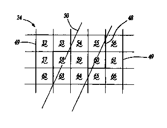
10
invention;
Figure 2 is a map displayed by the display of Figure 1; and
Figure 3 is an enlarged view of a area 3 of Figure 2.
DETAILED DESCRIPTION OF THE P ~ ~ ~ i D EMBODIMENT
The navigation system 20 of the present invention is shown
schematically in Figure 1. The navigation system 20 includes a CPU 22
connected to a display 24, such as a high resolution LCD or flat panel
display.
The CPU 22 is also connected to an input device 26 such as a mouse,
keyboard, key pad, microphone or remote device. Alternatively, the display
24 can be a touch screen display. The navigation system 20 further includes
a storage device 28, such as a hard drive 28 or CD ROM, connected to the
CPU 22. The storage device 28 contains a database including a map of all the
roads in the area to be traveled by the vehicle 32 and may contain the
software
for the CPU 22, including the graphical user interface, route guidance,
operating system, position-determining software, etc.
The navigation system 20 preferably includes position and motion
determining devices, such as a GPS receiver 34, a gyroscope 36, a compass
38, a wheel speed sensor 40 and an orthogonal multiple axis accelerometer 42
all connected to the CPU 22 (connections not shown for simplicity). Such
position and motion determining devices are well known and are commercially
available.
The navigation system 20 determines the position of the vehicle
32 relative to the database of roads utilizing the position and motion
determining devices. The driver selects a destination relative to the database
of roads utilizing the user input device 26 and the display 24. The navigation
system 20 then displays turn-by-turn instructions to the driver to guide the
driver to the desired destination from the present position.

CA 02330783 2000-11-O1
WO 99/57518 PCT/US99/08462
-4_
In the present invention, the CPU 22 includes memory 44, preferably
RAM or flash RAM, storing the necessary software and data as well as a
palette 46 of colors which can be displayed on the display 24 at one time. The
color palette 46 is generally a known technique for displaying colors in
computers and in navigation systems. Preferably, the palette 46 contains 256
colors including 5 colors of 16 shades each.
The operation of the display 24 will be described with respect to
displaying maps, as shown in Figures 2, for illustration purposes. It should
be recognized that the same technique could be used for displaying icons,
menus and other objects on the display 24. Figure 2 shows the display 24 of
Figure 1 displaying a map of roads 48 displayed against a background 49.
Figure 3 illustrates a portion of a road 48 on display 24 from Figure
2, compared to the ideal road 50. The road 48 shown in Figure 3 could be
alternatively be a portion of text, icon or other displayed object from Figure
2. In a manner similar to a well known anti-aliasing algorithm, the pixels in
the road 48 are compared with ideal road 50. In the present invention using
paletted colors the road 48 is displayed in a first color adjacent a
background
49 of a second color. Each pixel 53-55, 58-60 and 63-65 is mathematically
compared to the ideal road 50 and then displayed at an appropriate shade of
the color. Each of the 5 colors has 16 shades available, 0-15, with 15 having
the highest intensity and 0 having the lowest intensity. If the pixel is
completely within the ideal road 50, the pixel is displayed at shade level 15,
the highest intensity of the first color. The intensity of that color is
reduced
proportionally for pixels which are not completely within the ideal road 50.
Preferably, a pixel for which it is mathematically determined should be less
than level 4 would be simply switched to the color of the background 49 rather
than reduced in intensity further.
Referring specifically to Figure 3, pixels 52, 56, 57, 61, 62 and 66 are
0% in the ideal object 50 and are therefore 100% the color of the background
49. Similarly, pixel 59 is 100% within the ideal and therefore has level 15
intensity for the first color of the road 48. Pixels 54 and 64 are
approximately

CA 02330783 2000-11-O1
WO 99/57518 PGTNS99/08462
-5-
95 % within the ideal object and therefore preferably have a level 14
intensity
of the first color of the road 48. Pixels 55 and 63 are approximately 75
within the ideal object 50 and are therefore preferably assigned level 13
intensity for the color of the road 48. Pixels 53, 58, 60 and 65 are less than
50% within the ideal object 50 and are therefore assigned the color of the
background 49.
The navigation system 20 of the present invention provides a simple
and efficient technique which improves the display of the roads. The overall
appearance of the display 24 is improved without the need to increase the
resolution of the display 24 or the power requirement of the CPU 22.
In accordance with the provisions of the patent statutes and
jurisprudence, exemplary configurations described above are considered to
represent a preferred embodiment of the invention. However, it should be
noted that the invention can be practiced otherwise than as specifically
illustrated and described without departing from its spirit or scope.

Representative Drawing
A single figure which represents the drawing illustrating the invention.
Administrative Status

2024-08-01:As part of the Next Generation Patents (NGP) transition, the Canadian Patents Database (CPD) now contains a more detailed Event History, which replicates the Event Log of our new back-office solution.

Please note that "Inactive:" events refers to events no longer in use in our new back-office solution.

For a clearer understanding of the status of the application/patent presented on this page, the site Disclaimer , as well as the definitions for Patent , Event History , Maintenance Fee  and Payment History  should be consulted.

Event History

Description Date
Inactive: IPC from MCD 2006-03-12
Application Not Reinstated by Deadline 2003-04-16
Time Limit for Reversal Expired 2003-04-16
Deemed Abandoned - Failure to Respond to Maintenance Fee Notice 2002-04-16
Letter Sent 2001-04-06
Inactive: Single transfer 2001-03-08
Inactive: Cover page published 2001-02-27
Inactive: First IPC assigned 2001-02-25
Inactive: Courtesy letter - Evidence 2001-02-20
Inactive: Notice - National entry - No RFE 2001-02-14
Application Received - PCT 2001-02-12
Application Published (Open to Public Inspection) 1999-11-11

Abandonment History

Abandonment Date Reason Reinstatement Date
2002-04-16

Maintenance Fee

The last payment was received on 2001-04-17

Note : If the full payment has not been received on or before the date indicated, a further fee may be required which may be one of the following

  • the reinstatement fee;
  • the late payment fee; or
  • additional fee to reverse deemed expiry.

Please refer to the CIPO Patent Fees web page to see all current fee amounts.

Fee History

Fee Type Anniversary Year Due Date Paid Date
Registration of a document 2000-11-01
Basic national fee - standard 2000-11-01
MF (application, 2nd anniv.) - standard 02 2001-04-17 2001-04-17
Owners on Record

Note: Records showing the ownership history in alphabetical order.

Current Owners on Record
MAGELLAN DIS, INC.
Past Owners on Record
ANTHONY ALBERT SLOMINSKI
JEFFREY ALAN MILLINGTON
Past Owners that do not appear in the "Owners on Record" listing will appear in other documentation within the application.
Documents

To view selected files, please enter reCAPTCHA code :


To view images, click a link in the Document Description column. To download the documents, select one or more checkboxes in the first column and then click the "Download Selected in PDF format (Zip Archive)" or the "Download Selected as Single PDF" button.

List of published and non-published patent-specific documents on the CPD .

If you have any difficulty accessing content, you can call the Client Service Centre at 1-866-997-1936 or send them an e-mail at CIPO Client Service Centre.


Document
Description 
Date
(yyyy-mm-dd) 
Number of pages   Size of Image (KB) 
Representative drawing 2001-02-27 1 6
Description 2000-11-01 5 223
Abstract 2000-11-01 1 55
Claims 2000-11-01 3 86
Drawings 2000-11-01 1 27
Cover Page 2001-02-27 1 42
Reminder of maintenance fee due 2001-02-13 1 112
Notice of National Entry 2001-02-14 1 194
Courtesy - Certificate of registration (related document(s)) 2001-04-06 1 113
Courtesy - Abandonment Letter (Maintenance Fee) 2002-05-14 1 183
Correspondence 2001-02-14 1 24
PCT 2000-11-01 10 341
Fees 2001-04-17 1 27