Note: Descriptions are shown in the official language in which they were submitted.
CA 02331684 2000-11-03
WO 99/57576 PC1'NS99/08085
METHOD AND APPARATUS FOR OPERATING A SATELLITE
POSITIONING SYSTEM RECEIVER
BACKGROUND OF THE INVENTION
The present invention relates to a method for operating a Satellite
Positioning System (SPS) receiver and more particularly relates to a system in
which the receiver provides, through a wireless communication link,
information
regarding its position.
Conventional Satellite Positioning Systems (SPS) such as the Global
Positioning System (GPS) use signals from satellites to determine their
position.
GPS receivers normally determine their position by computing relative times of
arrival of signals transmitted simultaneously from a multiplicity of GPS
satellites.
These satellites transmit, as part of their message, both satellite
positioning data as
well as data on time of day plus clock timing, which together is herein
referred to
as ephemeris data. The process of searching for and acquiring GPS signals,
reading the ephemeris data for a multiplicity of satellites and computing the
location of the receiver from this data is time consuming, often requiring
several
minutes. In many cases, this lengthy processing time is unacceptable and
furthermore greatly limits battery life in portable operations and
applications.
Another current limitation of current GPS receivers is that their operation is
limited to situations in which multiple satellites are clearly in view,
without
obstructions, and where a good quality antenna is properly positioned to
receive
such signals. As such, they are normally unusable in portable body-mounted
applications and in areas where there is significant foliage or building
blockage and
within buildings.
There are two principal functions of GPS receiving systems: ( 1 )
computation of the pseudoranges to the various GPS satellites; and (2)
computation of the position of the receiving platform using these pseudoranges
and satellite timing and ephemeris data. The pseudoranges are simply the time
delays measured between the received signal from each satellite and a local
clock in
the GPS receiver. The satellite ephemeris and timing data is extracted from
the
GPS signal once it is acquired and tracked. As stated above, collecting this
information normally takes a relatively long time (such as thirty seconds to
several
CA 02331684 2000-11-03
WO 99!57576 PCT/US99/08085
-2-
minutes) and must be accomplished with a good received signal level in order
to
achieve low error rates.
Recently, GPS receivers have been used with radio transmitters, such as a
cellular telephone or a mobile telephone in a car to transmit the position of
the
receiver as it moves. Conventional combined GPS/communication systems
typically transmit a position from the radio transmitter to a remotely located
basestation. Typically, the GPS receiver will determine its position and then
provide that information to the transmitter which then transmits the
determined
position before the GPS receiver has determined a next position. This allows
an
operator at the remotely located basestation which receives, through the radio
signal, the position to track the route of the GPS receiver as it moves over
time. In
an alternative embodiment, described for example in U.S. Patent 5, 663,734,
the
mobile GPS receiver which includes a communication transmitter transmits time-
tagged pseudorange information rather than a completed position calculation
(such
as latitude, longitude, and altitude of the GPS receiver). In this case, the
mobile
unit, which includes the GPS receiver, will collect GPS signals and processes
those signals to determine pseudoranges to the various satellites in view at a
particular time and then the transmitter will transmit these pseudoranges to a
remotely located basestation which will then process these pseudoranges with
the
time tags of the pseudoranges plus ephemeris data collected at or supplied to
the
basestation in order to determine a position of the mobile unit. Also in this
case,
the transmitter will transmit one set of pseudoranges before the GPS receiver
determines a next set of pseudoranges.
While both of these prior approaches provide a way to track the route of a
moving GPS receiver, there are several concerns with using these techniques.
In
the case of the mobile GPS receiver which determines its position and
transmits
the position to a remotely located basestation, the mobile unit must have a
good
view of the sky and receive multiple satellites clearly in order to be able to
compute
the pseudoranges and to read the ephemeris data before the GPS receiver can
determine its position. Furthermore, in the case where this mobile GPS
receiver
attempts to compute several positions and then transmit them in one
transmission,
this receiver will typically not be able to benefit from differential GPS
corrections,
unless a large set of differential corrections is buffered at the basestation.
A
mobile GPS receiver which collects a series of digitized samples of GPS
signals
CA 02331684 2005-05-02
74769-301
-3-
and transmits the series in one transmission will consume
large amounts of battery power and may cause congestion in
the wireless link due to the large amount of data being
collected, stored and transmitted. See, for example,
European Patent Application 0 508 405.
In the case of the mobile GPS receiver which
transmits pseudoranges one at a time, the communication
transmitter must be repeatedly powered up in order to
transmit each set of pseudoranges after they have been
determined. This may tend to decrease battery life in the
mobile unit and may also cause congestion in the wireless
communication link between the mobile unit and a
basestation. Furthermore, the air time costs may be high
for such an operation.
Thus it is desirable to provide an improved method
and system for providing multiple sets of position
information over a period of time through a mobile GPS unit.
SUMMARY OF THE INVENTION
The present invention provides methods and
apparatuses for operating a satellite positioning system
receiver so that the position of the receiver can be tracked
over time.
In one example of a method according to the
present invention, a first plurality of pseudoranges at a
first time is determined, and a second (and perhaps
additional) plurality of pseudoranges is determined at a
second (and perhaps additional) time which is after the
first time. The first plurality of pseudoranges is
sufficient to enable a location of the SPS receiver to be
obtained at the first time and the second plurality of
pseudoranges is sufficient to enable a location of the SPS
CA 02331684 2005-05-02
74769-301
-4-
receiver to be determined at the second time. The first
plurality of pseudoranges and the second plurality of
pseudoranges are stored in the satellite positioning system
receiver. After the second time, the first plurality of
pseudoranges and the second plurality of pseudoranges are
transmitted from the mobile SPS receiver.
In one particular example of a method of the
present invention, a queue of sets of pseudoranges taken in
series over time is stored and then transmitted upon the
occurrence of a predetermined type of event from the mobile
GPS unit or an alarm condition. The transmission occurs in
response to determining that the predetermined type of event
has occurred or an alarm condition has occurred. Typically,
the GPS receiver will receive first GPS signals from which
the first plurality of pseudoranges is determined and will
also receive second GPS signals from which the second
plurality of pseudoranges is determined. The mobile unit
will also determine a first receipt time when the first GPS
signals were received at the mobile unit and will also
determine a second receipt time when the second GPS signals
were received at the mobile unit. These receipt times will
be transmitted along with the sets of pseudoranges. A
basestation will receive the queue of sets of pseudoranges
either in one signal transmission or in a packet-like manner
and will use the pseudoranges along with the receipt times
of the pseudoranges and along with ephemeris data to
determine the position at various times specified by the
receipt times of the mobile GPS unit. If the predetermined
type of event (or the alarm condition) does not occur, then
the pseudorange information may not, in some embodiments, be
transmitted at any time. Various other aspects and
embodiments of the present invention will be described
below.
CA 02331684 2005-05-02
74769-301
-4a-
According to another aspect, the invention
provides a mobile Satellite Positioning System (SPS)
.,
receiver comprising: an SPS RF (radio frequency) receiver
which receives SPS signals; a processor coupled to said SPS
RF receiver to determine a plurality of pseudoranges from
said SPS signals, wherein said processor: determines a
first plurality of pseudoranges from SPS signals received at
a first time sufficient to enable a position of said
receiver to be determined at said first time; and determines
a second plurality of pseudoranges from SPS signals received
at a second time which is after said first time sufficient
to enable a position of said receiver to be determined at
said second time; a memory coupled to said processor, said
memory storing said first plurality of pseudoranges and said
second plurality of pseudoranges; and a transmitter coupled
to said memory, said transmitter transmitting said first
plurality of pseudoranges and said second plurality of
pseudoranges after said second time.
The invention may also be summarized from a
different aspect as a method of determining position from
satellite positioning system (SPS) information, said method
comprising: receiving a first plurality of pseudoranges
which were determined from first SPS signals received at a
first time, said first plurality of pseudoranges being
sufficient to enable a location of said SPS receiver to be
determined at said first time; receiving a second plurality
of pseudoranges which were determined from second SPS
signals received at a second time which is after said first
time, said second plurality of pseudoranges being sufficient
to enable a location of said SPS receiver to be determined
at said second time; and determining a first position from
said first plurality of pseudoranges and determining a
second position from said second plurality of pseudoranges,
CA 02331684 2005-05-02
74769-301
-4b-
wherein said first plurality of pseudoranges and said second
plurality of pseudoranges were received in one transmission
after said second time.
BRIEF DESCRIPTION OF THE DRAWINGS
The present invention is illustrated by way of
example and not limitation in the figures of the
accompanying drawings in which like references indicate
similar elements.
Figure 1A shows a system for tracking the route of
a mobile GPS unit according to one example of the present
invention.
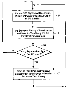
Figure 1B shows one example of a method performed
by the mobile GPS unit in order for a remotely located
location server to determine the position at various times
of the mobile unit.
Figure 1C shows one example of a method in which a
location server determines various positions from a queue of
sets of pseudoranges taken over time by a mobile unit.
Figure 2 shows another example of a system for
tracking the location of mobile units over time using a cell
based communication system.
Figure 3 shows an example of a location server
which may be used with a cellular based communication system
in one example of the present invention.
Figure 4 shows an example of a mobile GPS receiver
which is combined with a communication system according to
one example of the present invention.
CA 02331684 2005-05-02
74769-301
-4c-
Figure 5 shows an example of a GPS reference
station which may be used with one example of the present
invention.
DETAILED DESCRIPTION
The present invention relates to the use of a
satellite positioning system (SPS) receiver to provide
position information over time to indicate the movement
CA 02331684 2000-11-03
WO 99/57576 PCTNS99/08085
-5-
of the receiver. The following description and drawings are illustrative of
the
invention and are not to be construed as limiting the invention. Numerous
specific
details are described to provide a thorough understanding of the present
invention.
However, in certain instances, well known or conventional details are not
described in detail in order to avoid unnecessarily obscuring the present
invention.
Figure 1 shows an example of a system for tracking the location of a
mobile GPS receiver over time as it moves. The mobile GPS receiver 12 is shown
on a map at its current location on road 11. Prior locations 14, 16, 18, 20,
22,
and 24 are also shown on road 11. In the particular example shown in Figure
1A, it is assumed that the user of the mobile GPS receiver 12 has driven down
the
road 11 and began at location 14, passing location 16, 18, 20, 22, and 24 and
is
now presently at the location shown in Figure 1A. The mobile GPS receiver 12
includes a GPS receiver, which may be a conventional GPS receiver which can
provide an output of pseudoranges to a transmitter which is part of a
communication system such as the communication system 78 shown in Figure 4
which is an example of the mobile GPS receiver 12. Alternatively, the mobile
GPS receiver 12 may be similar to the GPS receiver and communication system
described in U.S. Patent 5, 663,734. In either embodiment, the mobile GPS
receiver 12 will include a memory for storing pseudoranges and a time stamp
indicating when the GPS signals were received from which the pseudoranges were
determined.
The system of Figure 1A also includes a location server 25 which
communicates through a wireless communication system with the communication
system which is coupled to or part of the mobile GPS unit 12. The basestation
25
typically includes storage 26 for storing a time sequence of differential GPS
and
satellite ephemeris information. The basestation 25 also typically includes a
GPS
reference receiver 27 which can read satellite ephemeris data from satellites
in view
and can also provide GPS time and also provide differential GPS information.
Thus, the GPS reference receiver 27 may determine differential GPS and
satellite
ephemeris information and time stamp it with GPS time and the basestation can
then store this in the storage 26. This operation is repeatedly performed over
time
so that there is a queue of ephemeris and differential GPS information for the
various satellites in view over a period of time.
CA 02331684 2005-05-02
74769-301
-6-
In other embodiments, the GPS receiver 27 may be replaced by a remote
source of the same type of information that this receiver provides to the
basestation
server 25. For example, a small network of GPS receivers may be utilized to
provide such information to a large number of geographically dispersed
basestations, thus reducing the total number of GPS reference receivers
requittd.
Figure 1B shows an example of a method according to the present
invention. This method begins in step 31 in which GPS signals are received by
the mobile GPS unit and a plurality of pseudoranges to a plurality of GPS
satellites
is determined. As explained above, the GPS receiver may be a conventional
receiver which utilizes hardware correlation to determine pseudoranges.
Alternatively, the pseudoranges may be detern lined in the manner described in
U.S. Patent 5,663,734. As yet another alternative, the GPS signals may be
received and digitized and stored along with a time stamp indicating the time
in
which the signals were received. In this case, these digitized signals, rather
than
pseudoranges, will be transmitted. This alternative acquires larger memory and
larger transmission bandwidth in order to store and transmit this considerably
larger amount of data. In step 33, the plurality of pseudoranges is time
stamped
and this plurality of pseudoranges is stored along with the corresponding time
stamp. The time stamp may be obtained by reading GPS time from the GPS
signals received by the mobile unit or may be obtained in certain
instances~where
the communication system employed for communicating messages between the
mobile unit 12 and the basestation 25 utilizes the CDMA cell communication
system. The CDMA signals include time as part of the signal and the
communication system and the mobile unit 12 can read this time, and use it to
time
stamp the time of receipt of the GPS signals from which the pseudoranges ate
determined. Another method for determining tlu time of collection of ttn GPS
signals from which the pseudoranges is determined is described in U.S. Patent
No. 5,812,087.
In one example of a method according to the present invention, it is
determined whether a predetermined type of event has occurred (or an alarm
condition has occurred), as shown in step 35. While it will be understood that
this
step is optional, it will typically be used in order to determine whether or
not to
transmit the pseudoranges which have been stored along with their
corresponding
CA 02331684 2000-11-03
WO 99/57576 PCTNS99/08085
_7_
time stamps. If the predetermined type of event has not occurred (or an alarm
condition), then processing returns back to step 31 in which additional GPS
signals are received and additional pseudoranges are determined. Until the
predetermined type of event (or an alarm condition) occurs, processing
continues
to cycle through steps 31, 33, and 35, thereby collecting a plurality of
pseudoranges taken at different times, each with its own time stamp, all of
which
is stored in memory in the mobile unit 12. An example of this memory is shown
as memory 81 in Figure 4. When the predetermined type event does occur, step
35 proceeds to step 37 in which the stored pseudoranges and the corresponding
time stamps are transmitted via a wireless communication system, such as a
CDMA cell based communication signal to the location server. Also, as shown in
step 37, the memory which stored the pseudoranges and the time stamps is
cleared
for that portion of the memory. This will permit another set of pseudoranges
to be
collected along with their corresponding time stamps and stored and later
transmitted.
This method provides a number of advantages over the prior art technique
of determining a position at each point and then transmitting these positions.
It is
also advantageous relative to another example in which several positions are
determined over time but not transmitted, and then transmitted after a
collection of
positions is obtained. Attempting to determine the position of the mobile unit
will
require an adequate view of the sky as well as an adequate ability to read the
signals off of enough satellites in order to obtain the satellite ephemeris
data.
Furthermore, such a method does not allow for the use of differential GPS
(DGPS) information which will improve the accuracy of the position calculation
(unless the communication link is used to transmit the DGPS data, which will
use
more power). With the method of the present invention, only the pseudoranges
need to be determined by the mobile unit over time. Thus it is not required to
be
able to read the satellite ephemeris data. With the improved processing
techniques
described in U.S. Patent 5,663,734, it is possible to obtain pseudoranges to
enough satellites in most instances even when the sky is obstructed or the
signals
are weak. The queuing of pseudoranges and transmission only upon the
occurrence of an event minimizes the transmission "air time" yet permits
determination upon demand of a history of the mobile's positions.
CA 02331684 2000-11-03
WO 99/57576 PCT/US99/08085
_g_
In the example shown in Figure 1A, the mobile GPS receiver 12 will
receive GPS signals at positions 14, 16, 18, 20, 22, 24, and its current
position
and will determine pseudoranges from those signals and store those
pseudoranges
along with the corresponding time stamp in memory. If the predetermined type
of
event is the collection of the seventh set of signals from which pseudoranges
are
determined, then the mobile unit 12 will transmit all seven pseudoranges and
the
corresponding time stamps at the position shown in Figure 1A for the mobile
unit 12. There are numerous other possible predetermined events which could
cause the transmission of the sequence of time stamped pseudoranges. One, as
already mentioned, is that a certain number of stored pseudoranges has been
reached. Another predetermined type of event may be a sensor or alarm which
detects an alarm condition or some other condition and which causes the
transmission of the stored pseudoranges. One such example is the detection in
a
car of an accident or the fact that an airbag has inflated or the fact that
the car alarm
is on. Another predetermined event may be that the basestation asks for the
transmission of the stored pseudoranges in order to attempt to locate the
current
position of the mobile GPS receiver as well as the prior position as indicated
in the
queue of time stamped pseudoranges. Another predetermined event may be that
the memory limit has been reached for storing pseudoranges. Another
predetermined event may be that a predetermined period of time has lapsed
since
the last transmission of pseudoranges. If this time is varied, it may also
cause a
corresponding variance in the number of saved pseudoranges by varying the
interval between which GPS signals are collected and processed to determine
pseudoranges. In another example of a predetermined event, it may merely be
the
user pressing a button on the mobile GPS receiver.
Figure 1C shows an example of the operations performed according to a
method of the present invention on a location server, such as the location
server
25. The method of Figure 1C begins in step 41 in which the location receiver
determines and stores a plurality of differential GPS corrections for each of
a
series of points in time and also stores a time stamp for each corresponding
plurality of differential GPS corrections. As described above in the system of
Figure 1A, the location server 25 may receive or determine differential GPS
corrections from the GPS reference receiver having a known location. In the
case
where the basestation and mobile unit use point-to-point radio communications
CA 02331684 2000-11-03
WO 99/57576 PCT/US99/08085
-9-
(and not a widely-dispersed cell based system), the GPS reference receiver
typically is co-located with the location server and typically also has the
same
satellites in view as mobile units which are being tracked by the location
server 25.
The GPS reference receiver 27 may determine differential GPS corrections in
the
conventional manner and also provide GPS time indicating the point in time
when
the GPS signals, from which the differential GPS corrections were determined,
were received and provide this set of information for each point in time to
the
location server which causes this information to be stored in storage 26. It
will be
understood that step 41 will typically occur repeatedly during the overall
procedure
shown in Figure 1C. That is, the operation described in step 41 will be
repeated
and will be occurnng continually in order to obtain a queue of differential
GPS
corrections and the corresponding time stamps for each correction. This will
allow
differential GPS collections to be made over an extended period of time of
travel of
a mobile unit, such as the mobile unit 12. For example, if the mobile unit 12
takes
one hour to travel from position 14 to its current position past position 24
shown
in road 11, then at least one hour of differential GPS corrections may be
required.
However, if there is a limit in the duration required to determine position
history of
each mobile, then the queue size of these corrections may be kept small (for
example, the queue may correspond to the last one minute period).
It will be appreciated that when a basestation (location server) services a
large geographical area, that a reference network of GPS reference receivers
providing differential corrections over the entire network may be required.
This is
further described below. Returning back to Figure 1C, in step 43, the location
server receives a transnussion containing several sets of pseudoranges and the
corresponding time stamp for each set. It will be appreciated that while the
pseudoranges and the time stamps may be transmitted in one transmission, this
transmission may be over several packets of data or may be interrupted,
although
for purposes of the present invention this may still be considered a single
transmission of the queue of pseudoranges which have been time stamped. In
step
45, the location server selects the most appropriate differential GPS
correction to
use with each set of pseudoranges by comparing the time stamps for the
differential GPS corrections and the time stamps for each set of pseudoranges.
In
effect, the location server determines the differential GPS correction whose
time of
applicability is closest in time to the time stamp of the pseudorange. After
CA 02331684 2000-11-03
WO 99/57576 PC'T/US99/08085
-10-
selecting the appropriate differential GPS correction, the set of pseudoranges
are
corrected with these differential GPS corrections. It will be appreciated that
while
the preferred embodiment uses this queue of differential GPS corrections, it
is not
necessary to practice certain embodiments of the present invention. In step
47, the
location server determines a position of the transmitting mobile GPS unit from
each set of corrected pseudoranges and the corresponding time stamp. In this
manner, the location server can determine that the mobile unit 12 was at
position
14 at the time indicated by the time stamp associated with the pseudoranges
obtained when the mobile unit was at position 14, and the location server can
also
determine the positions 16, 18, 20, 22, 24, and its current location and
determine
the time the mobile unit was at these positions. In this manner, the location
server
may be able to track the movement of mobile unit in space and in time. This
information is used in step 49 in a number of different ways. For example, the
basestation may provide concierge services or routing information to the
operator
of mobile unit 12 by transmitting help information back to the mobile unit 12
through the wireless communication system.
Having a time history of pseudoranges from which a time history of
positions are computed allows the server to track the mobile's position and
velocity. This is important for locating a mobile in an emergency situation,
such
as an automobile accident in which the mobile antenna is incapacitated.
While the foregoing description generally assumed a point-to-point
communication system between the communication system of the mobile unit 12
and the communication system of the basestation 25, it will be understood that
the
communication system may be a cell based communication system as described
below.
Figure 2 shows one example of a system 101 of the present invention.
The system includes a cell based communication system which includes a
plurality
of cell sites, each of which is designed to service a particular geographical
region
or location. Examples of such cellular based or cell based communication
systems
are well known in the art, such as the cell based telephone systems. It will
be
appreciated that Figure 2 has not been drawn to show an overlap of cells.
However, the signal coverage zone of the cells may in fact overlap. The cell
based
communication system as shown in Figure 1 includes three cells 102, 103, and
104. It will be appreciated that a plurality of cells with corresponding cell
sites
CA 02331684 2000-11-03
WO 99/57576 PCT/US99/08085
-11-
and/or cellular service areas may also be included in the system 101 and be
coupled to one or more cell based switching centers, such as the mobile
switching
center 105 and the mobile switching center 106. Within each cell, such as the
cell
102, there is a wireless cell basestation (sometimes referred to as a cell
site) such
as the cell basestation 102a which is designed to communicate through a
wireless
communication medium using cell based communication signals with a
communication system, which typically includes a receiver and a transmitter
for
communicating by using the cell based communication signals and a mobile GPS
receiver. This combined communication system and mobile GPS receiver
provides a combined system such as the receiver 102b shown in Figure 2. An
example of such a combined system having a GPS receiver and a communication
system is shown in Figure 4 and may include both the GPS antenna 77 and a
communication system antenna system 79. Each cell site is coupled typically to
a
mobile switching center. In Figure 2, cell bases 102a and 103a are coupled to
switching center 105 through connections 102c and 103c, respectively, and cell
base 104a is coupled to a different mobile switching center 106 through
connection
104c. These connections are typically wireline connections between the
respective
cell base and the mobile switching centers 105 and 106. Each cell base
includes an
antenna for communicating with communication systems serviced by the
particular
cell site/base. In one example, the cell site may be a cellular telephone cell
site
which communicates with mobile cellular telephones (integrated with a GPS
receiver) in the area serviced by the cell site.
In a typical embodiment of the present invention, the mobile GPS receiver,
such as receiver 102b, includes a cell based communication system which is
integrated with the GPS receiver such that both the GPS receiver and the
communication system are enclosed in the same housing. One example of this is
a
cellular telephone having an integrated GPS receiver which shares common
circuitry with the cellular telephone transceiver. When this combined system
is
used for cellular telephone communications, transmissions occur between the
receiver 102b and the cell base 102x. Transmissions from the receiver 102b to
the
cell base 102a are then propagated over the connection 102c to the mobile
switching center 105 and then to either another cellular telephone in a cell
serviced
by the mobile switching center 105 or through a connection (typically wired)
to
another telephone through the land-based telephone system/network 112. It will
CA 02331684 2000-11-03
WO 99/57576 PCT/US99/08085
-12-
be appreciated that the term wired includes fiber optic and other non wireless
connections such as copper cabling, etc. Transmissions from the other
telephone
which is communicating with the receiver 102a are conveyed from the mobile
switching center 105 through the connection 102c and the cell base 102a back
to
the receiver 102b in the conventional manner.
In the example of Figure 2, each mobile switching center (MSC) is
coupled to at least one regional short message service center (SMSC) through a
communication network 115 which in one embodiment is referred to as a
Signaling System Number 7 (SS7) Network. This network is designed to allow
short messages (e.g. control information and data) to be passed among elements
of
the telephone network. It will be understood that Figure 2 shows one example
and that it is possible for several MSC's to be coupled to one regional SMSC.
The
network 115 interconnects MSC's 105 and 106 to regional SMSC's 107 and 108.
The example of Figure 2 also shows two GPS location servers 109 and 110
which are coupled to regional SMSC 107 and regional SMSC 108 through the
network 115. In one embodiment of the distributed system of Figure 2, the
network 115 may be a permanent packet switched data network which
interconnects various regional SMSC's and MSC's with various GPS location
servers. This allows each regional SMSC to act as a router to route requests
for
location services to whichever GPS location servers are available in case of
congestion at a location server or failure of a location server. Thus,
regional
SMSC 107 may route location service requests from mobile GPS receiver 102b
(e.g. the user of mobile GPS receiver 102b dials 911 on the integrated cell
telephone) to the GPS location server 110 if location server 109 is congested
or
has failed or is otherwise unable to service the location service request.
Each GPS location server is typically coupled to a wide area network of
GPS reference stations which provide differential GPS corrections and
satellite
ephemeris data to the GPS location servers. This wide area network of GPS
reference stations, shown as GPS reference network 111, is typically coupled
to
each GPS location server through a dedicated packet switched data network.
Hence, location server 109 receives data from the network 111 through
connection
109a and server 110 receives data from network 111 through connection 110a.
The reference network 111 may be coupled to the communication network 112.
Alternatively, a GPS reference receiver may be used at each location server to
CA 02331684 2000-11-03
WO 99/57576 PCT/US99/08085
-13-
provide satellite ephemeris and GPS time to the GPS location server. As shown
in
Figure 2, each GPS location server is also coupled to a communication network
such as a public switched telephone network (PSTN) 112 to which two
application
servers 114 and l 1b are coupled.
The two GPS location servers are, in one embodiment, used to determine
the position of a mobile GPS receiver (e.g. receiver 102b) using GPS signals
received by the mobile GPS receiver.
Each GPS location server will receive pseudoranges from a mobile GPS
receiver and satellite ephemeris data from the GPS reference network and
calculate
a route of positions for the mobile GPS receiver and then these positions will
be
transmitted through the network 112 (e.g. the public switched telephone
network
PSTN) to one (or both) of the Application Servers where the positions are
presented (e.g. displayed on a map) to a user at the Application Server.
Normally,
the GPS location server calculates but does not present (e.g. by display) the
positions at the GPS location server. An application server may send a
request,
for the positions of a particular GPS receiver in one of the cells, to a GPS
location
server which then initiates a conversation with a particular mobile GPS
receiver
through the mobile switching center in order to determine the route of
positions of
the GPS receiver and report those positions back to the particular
application. In
another embodiment, a position determination for a GPS receiver may be
initiated
by a user of a mobile GPS receiver; for example, the user of the mobile GPS
receiver may press 911 on the cell phone to indicate an emergency situation at
the
location of the mobile GPS receiver and this may initiate a location process
in the
manner described herein.
It should be noted that a cellular based or cell based communication system
is a communication system which has more than one transmitter, each of which
serves a different geographical area, which is predefined at any instant in
time.
Typically, each transmitter is a wireless transmitter which serves a cell
which has a
geographical radius of less than 20 miles, although the area covered depends
on
the particular cellular system. There are numerous types of cellular
communication
systems, such as cellular telephones, PCS (personal communication system),
SMR (specialized mobile radio), one-way and two-way pager systems, RAM,
ARDIS, and wireless packet data systems. Typically, the predefined
geographical
areas are referred to as cells and a plurality of cells are grouped together
into a
CA 02331684 2000-11-03
WO 99/57576 PCT/US99/08085
-14-
cellular service area and these pluralities of cells are coupled to one or
more cellular
switching centers which provide connections to land-based telephone systems
and/or networks. A service area is often used for billing purposes. Hence, it
may
be the case that cells in more than one service area are connected to one
switching
center. Alternatively, it is sometimes the case that cells within one service
area are
connected to different switching centers, especially in dense population
areas. In
general, a service area is defined as a collection of cells within close
geographical
proximity to one another. Another class of cellular systems that fits the
above
description is satellite based, where the cellular basestations or cell sites
are
satellites that typically orbit the earth. In these systems, the cell sectors
and service
areas may be very large and move as a function of time. Examples of such
systems include Iridium, Globalstar, Orbcomm, and Odyssey.
Figure 3 shows an example of a GPS location server 50 which may be
used as the GPS server 109 or GPS server 110 in Figure 2. The GPS server 50
of Figure 3 includes a data processing unit 51 which may be a fault-tolerant
digital computer system. The SPS server 50 also includes a modem or other
communication interface 52 and a modem or other communication interface 53 and
a modem or other communication interface 54. These communication interfaces
provide connectivity for the exchange of information to and from the location
server shown in Figure 3 between three different networks, which are shown as
networks 60, 62, and 64. The network 60 includes the mobile switching center
or
centers and/or the land-based phone system switches or the cell sites. An
example
of this network is shown in Figure 2 wherein the GPS server 109 represents the
server 50 of Figure 3. Thus the network 60 may be considered to include the
mobile switching centers 105 and 106 and the cells 102, 103, and 104. The
network 64 may be considered to include the Applications Servers 114 and 116,
which are each usually computer systems with communication interfaces, and
also
may include one or more "PSAP's," (Public Safety Answering Point) which is
typically the control center which answers 911 emergency telephone calls. The
network 62, which represents the GPS reference network 111 of Figure 2, is a
network of GPS receivers which are GPS reference receivers designed to provide
differential GPS correction information and also to provide GPS signal data
including the satellite ephemeris data to the data processing unit. When the
server
SO serves a very large geographical area, a local optional GPS receiver, such
as
CA 02331684 2000-11-03
WO 99/57576 PC'f/US99/08085
-15-
optional GPS receiver 56, may not be able to observe all GPS satellites that
are in
view of mobile SPS receivers throughout this area. Accordingly, the network 62
collects and provides satellite ephemeris data and differential GPS correction
data
over a wide area in accordance with the present invention.
As shown in Figure 3, a mass storage device 55 is coupled to the data
processing unit 51. Typically, the mass storage 55 will include storage for
data
and software for performing the GPS position calculations after receiving
pseudoranges from the mobile GPS receivers, such as a receiver 102b of Figure
2. These pseudoranges are normally received through the cell site and mobile
switching center and the modem or other interface 53. The mass storage device
55
also includes software, at least in one embodiment, which is used to receive
and
use the satellite ephemeris data provided by the GPS reference network 32
through
the modem or other interface 54. The mass storage device 55 also will
typically
include a database or storage 55a which specifies a queue of time stamped
satellite
ephemeris and differential GPS corrections as described above.
In a typical embodiment of the present invention, the optional GPS receiver
56 is not necessary as the GPS reference network 111 of Figure 2 (shown as
network 62 of Figure 3) provides the differential GPS information and
corresponding time stamps as well as providing the raw satellite data messages
from the satellites in view of the various reference receivers in the GPS
reference
network. It will be appreciated that the satellite ephemeris data obtained
from the
network through the modem or other interface 54 may be used in a conventional
manner with the pseudoranges obtained from the mobile GPS receiver in order to
compute the position information for the mobile GPS receiver. The interfaces
52,
53, and 54 may each be a modem or other suitable communication interface for
coupling the data processing unit to other computer systems in the case of
network
64 and to cellular based communication systems in the case of network 60 and
to
transmitting devices, such as computer systems in the network 62. In one
embodiment, it will be appreciated that the network 62 includes a dispersed
collection of GPS reference receivers dispersed over a geographical region. In
some embodiments, the differential correction GPS information, obtained from a
receiver near the cell site or cellular service area which is communicating
with the
mobile GPS receiver through the cellular based communication system, will
CA 02331684 2005-05-02
74769-301
-16-
provide differential GPS correction information which is appropriate for the
approximate location of the mobile GPS receiver.
Figure 4 shows a generalized combined system which includes a GPS
receiver and a communication system transceiver. In one example, the
communication system transceiver is a cellular telephone. The system 75
includes
a GPS receiver 76 having a GPS antenna 77 and a communication transceiver 78
having a communication antenna 79. The GPS receiver 76 is coupled to the
communication transceiver 78 through the connection 80 shown in Figure 4.
The memory 81 stores a queue of determined pseudoranges and corresponding
time stamps as described above. This memory 81 is coupled to the GPS receiver
76 and may also be coupled to the communication transceiver (e.g. the memory
is
dual ported). In one mode of operation, the communication system transceiver
78
receives approximate Doppler information through the antenna 79 and provides
this approximate Doppler information over the link 80 to the GPS receiver 76
which performs the pseudorange determination by receiving the GPS signals from
the GPS satellites through the GPS antenna 77. The determined pseudoranges are
then transmitted to a GPS location server through the communication system
transceiver 78. Typically the communication system transceiver 78 sends a
signal
through the antenna 79 to a cell site which then transfers this information
back to
the GPS location server. Examples of various embodiments for the system 75 arc
known in the art. For example, U.S. Patent 5, 663,734 describes an exampk of a
combined GPS receiver and communication system which utilizes an improved
GPS receiver system. Another example of a combined GPS and communication
system has been described in U.S. Patent No. 6,002,363. Most conventional GPS
receivers can be modified to work as the receiver 76 in Figure 4, although
receivers, such as those described in U.S. Patent No. 5,663,734 may provide
improved performance. The system 75 of Figure 4, as well as numerous
alternative communication systems having SPS receivers will typically time
stamp the time of the receipt of GPS signals from which pseudoranges are
determined. In particular, the system 75 may use GPS time (received or
estimated
from the GPS satellites) or use time from CDMA transmissions (in a preferred
embodiment) to time stamp the time of receipt at the mobile unit of SPS
signals.
CA 02331684 2000-11-03
WO 99/57576 PCT/US99/08085
-17-
Figure 5 shows one embodiment for a GPS reference station. It will be
appreciated that each reference station may be constructed in this way and
coupled
to the communication network or medium. Typically, each GPS reference station,
such as GPS reference station 90 of Figure 5, will include a dual frequency
GPS
reference receiver 92 which is coupled to a GPS antenna 91 which receives GPS
signals from GPS satellites in view of the antenna 91. GPS reference receivers
are
well known in the art. The GPS reference receiver 92, according to one
embodiment of the present invention, provides at least two types of
information as
outputs from the receiver 92. Pseudorange outputs 93 are provided to a
processor
and network interface 95, arid these pseudorange outputs (and the time at
which
the SPS signals, from which the reference pseudoranges were determined, were
received) are used to compute pseudorange differential corrections in the
conventional manner for those satellites in view of the GPS antenna 91. The
processor and network interface 95 may be a conventional digital computer
system
which has interfaces for receiving data from a GPS reference receiver as is
well
known in the art. The processor 95 will typically include software designed to
process the pseudorange data to determine the appropriate pseudorange
correction
for each satellite in view of the GPS antenna 91. These pseudorange
corrections
(and their corresponding time stamps) are then transmitted through the network
interface to the communication network or medium 96 to which other GPS
reference stations are also coupled. The GPS reference receiver 92 also
provides a
satellite ephemeris data output 94. This data is provided to the processor and
network interface 95 which then transmits this data onto the communication
network 96, which is included in the GPS reference network 111 of Figure 2.
The satellite ephemeris data output 94 provides typically at least part of the
entire raw 50 baud navigation binary data encoded in the actual GPS signals
received from each GPS satellite. This satellite ephemeris data is part of the
navigation message which is broadcast as the 50 bit per second data stream in
the
GPS signals from the GPS satellites and is described in great detail in the
GPS
ICD-200 document. The processor and network interface 95 receives this
satellite
ephemeris data output 94 and transmits it in real time or near real time to
the
communication network 96. As will be described below, this satellite ephemeris
data which is transmitted into the communication network is later received
through
CA 02331684 2005-05-02
74769-301
_ 18_
the network at various GPS location servers according to aspects of the
present
invention.
In certain embodiments of the present invention, only certain xgments of
the navigation message, such as the satellite ephemeris data message may be
xnt
to location xrvers in order to lower the bandwidth requirements for the
network
interfaces and for the communication network. 'Typically, also, this data may
not
need to be provided continuously. For example, only the first three frames
which
contain ephemeris information rather than all 5 frames together may be
transmitted
on a regular basis into the communication network 96 in real time or near real
time.
It will be appreciated that in one embodiment of the present invention, the
location
server may receive the entire navigation message which is transmitted from one
or
more GPS reference receivers in order to perform a method for measuring time
related to satellite data messages, such as the method described in above
mentioned U.S. Patent No. 5,812,087. As used herein, the term "satellite
ephemeris data" includes data which is only a portion of the satellite
navigation
message (e.g. 50 baud message) transmitted by a GPS satellite or at least a
mathematical representation of this satellite ephemeris data. For example, the
term satellite ephemeris data refers to a portion of the 50 baud data message
encoded into the GPS signal transmitted from a GPS satellite. It will be also
understood that the GPS reference receiver 92 decodes the different GPS
signals
from the different GPS satellites in view of the reference receiver 92 in
order to
provide the binary data output 94 which contains the satellite ephemeris data.
When a method of the present invention is used to track a route over time
of a mobile unit which the cell based system of ~guire ~, one location xrver
may
track the movement of a particular mobile unit from one cell to xveral otiur
cells.
Due to the interconnectivity of such a system, even receipt of signals from a
mobile unit which began in cell 102 may be tracked by the same location server
even after the mobile unit has moved to cell 104. Alternatively, one location
server
may transfer its route data indicating the positions and times which have been
determined for a particular mobile unit to another location xrver which takes
over
tracking of the mobile unit as it moves from one ceU site or cellular service
center
to another cell site or cellular servicx center.
CA 02331684 2000-11-03
WO 99/57576 PCTNS99/08085
-19-
Although the methods and apparatus of the present invention have been
described with reference to GPS satellites, it will be appreciated that the
teachings
are equally applicable to positioning systems which utilize pseudolites or a
combination of satellites and pseudolites. Pseudolites are ground based
transmitters which broadcast a PN code (similar to a GPS signal) modulated on
an
L-band carrier signal, generally synchronized with GPS time. Each transmitter
may be assigned a unique PN code so as to permit identification by a remote
receiver. Pseudolites are useful in situations where GPS signals from an
orbiting
satellite might be unavailable, such as tunnels, mines, buildings or other
enclosed
areas. The term "satellite", as used herein, is intended to include pseudolite
or
equivalents of pseudolites, and the term GPS signals, as used herein, is
intended
to include GPS-like signals from pseudolites or equivalents of pseudolites.
In the preceding discussion the invention has been described with reference
to application upon the United States Global Positioning Satellite (GPS)
system.
It should evident, however, that these methods are equally applicable to
similar
satellite positioning systems, and in, particular, the Russian Glonass system.
The
Glonass system primarily differs from GPS system in that the emissions from
different satellites are differentiated from one another by utilizing slightly
different
carrier frequencies, rather than utilizing different pseudorandom codes. In
this
situation substantially all the circuitry and algorithms described previously
are
applicable with the exception that when processing a new satellite's emission
a
different exponential multiplier corresponding to the different carrier
frequencies is
used to preprocess the data. The term "GPS" used herein includes such
alternative
satellite positioning systems, including the Russian Glonass system.
In the foregoing specification, the invention has been described with
reference to specific exemplary embodiments thereof. It will, however, be
evident
that various modifications and changes may be made thereto without departing
from the broader spirit and scope of the invention as set forth in the
appended
claims. The specification and drawings are, accordingly, to be regarded in an
illustrative rather than a restrictive sense.