Note: Descriptions are shown in the official language in which they were submitted.
CA 02342030 2001-03-23
Method and Apparatus for Providing Location Based Data Services
Field of the Invention:
The present invention relates generally to a method and system for generating,
storing,
manipulating and displaying location-based data and more particularly relates
to a
method and system for using a unique identifier of spatial location for to
enable a
database to become "location smart".
Background of the Invention:
Geographic Information systems or GIS systems have traditionally been used to
generate
and manipulate images and other geographic information. One common application
of
such systems is to allow users to build and generate maps. In general, a map
is a
collection of objects displayed simultaneously on a viewing device or on media
such as
paper. Maps and GIS systems are particularly important where the people,
places, things
or activities that the map or GIS system describes must be understood in a
geographic
context. Many commercial users have found GIS systems to be particularly
relevant to
their needs. These commercial users include telecommunications service
providers, who
often have to design, build and maintain complex networks of equipment where
knowledge of the physical location of the equipment is critical to efficient
and effective
network management.
Although the physical location of objects in GIS systems is often very
important, existing
systems do very little to allow users to understand the physical or abstract
location of
obj ects in a context that is easily understood by an end user and to easily
manipulate and
interact with the locational information relating to those objects. An example
of an
abstract location would be a street address. This is because in current
computer-based
GIS systems the obj ects are not inherently "location-smart." Location,
especially ab stract
location, may be attribute of such obj ects. However, in present systems
absolute physical
or abstract location is not an object itself, which limits user's ability to
understand, use
-1-
CA 02342030 2001-03-23
and manipulate location based information. Often the map that is displayed is
merely a
passive GIF (graphical interface format) file and conducting any spatial or
location based
analysis of objects within the map is complex and cumbersome.
Other computer based systems, including data bases, are also significantly
limited in the
way location based information is handled. A business may have many disparate
data
bases that all use or store locational information in slightly different ways.
For example,
a telecommunications service provider may have slightly different ways to
refer to (i) the
billing address of a residential customer; (ii) the service address; (iii)
addresses associated
with orders for products or services or removals or changes to existing
services; (iv)
directory addresses, legal land or municipal survey addresses; and, (v) the
location of
equipment such as telephone jacks. Also, the systems may capture addresses in
different
formats. Often information relating to these matters is captured in distinct
and
incompatible databases. In many organizations there may be dozens of such
disparate
1 S collections of data. It would be useful to these businesses to be able to
combine these
disparate collections of data based on the physical location of the subject
matter.
Most commercial GIS systems are poorly equipped to help remedy these problems.
As
stated earlier, the maps they produce do not have "location-smart" objects.
The GIS
systems use complex and proprietary data structures and it is often difficult
and
expensive for end users to integrate their disparate data collections with the
information
and functionality provided by the GIS systems. There is a strong need in the
current
marketplace for relatively unsophisticated users or those without an extensive
background in GIS systems to be able to incorporate location-based information
in their
applications, link disparate data collections on the basis of physical and or
abstract
location and to display and manipulate maps or other graphical presentations
that
incorporate their location-based data, or perform spatial analysis on the
location based
data.
These problems with handling location-based information also extend to the
Internet and
other communications networks such as intranets, and networks of wireless
devices and
-2-
CA 02342030 2001-03-23
personal digital assistants or PDA's. Thirty years ago the Internet was a
network
comprised of four nodes that were all physically located in the United States.
Today, the
Internet is a global network of networks consisting of approximately three
billion pages
of computerized on-line information that are connected by millions of
geographically
S dispersed nodes. The explosive growth of data available on the Internet has
created a
problem for those, such as Internet shoppers and Internet merchants, seeking
to exploit
it. The problem is that all this information remains largely unorganised in a
geographic
context. One of the only universal ways to navigate the web is through the use
of "key"
word searching. Internet index sites, such as YahooTM have created databases
that have
cross-referenced key words to specific Internet addresses. An Internet user,
searching for
information on a given topic, would enter search terms consisting of key words
relevant
to the given topic and the index would return a list of Internet sites or
pages that matched
the search criteria. However, key word searching is not adequate for location
specific
searching (e.g., an Internet user searching for wares or services that are
available within
a specified geographic area or a merchant who operates a web site and wishes
to advertise
not only the wares or services available, but also the geographic availability
of these
wares or services). There is also a need for Internet users to be able to
publish location
and time sensitive information easily on the Internet or any other searchable
networks.
To establish location requires that the geographic information (e.g., address,
postal code,
latitude-longitude co-ordinate) be associated with a geographic reference
system. This
is a complex process requiring specialized technology and map data that is
beyond the
means of the average mass market consumer or merchant. Existing solutions to
these
problems include the creation of on-line directories or local, city or
regional portals, many
of which use third party mapping services to cross- reference web-site
contents to simple
on-line maps. However, these existing solutions have thus far proved
inadequate. These
solutions are not universal; only content within the portal or directory can
be used and
only for pre-defined geographic areas. Further, the contents of these portals
is often
incomplete or not current. A third problem is that the maps generated are not
interactive;
Internet users often cannot plot their own data on a map and then perform a
spatial
operation or analysis on the map. An example of a spatial operation is
determining the
-3-
CA 02342030 2001-03-23
distance between two specified points. A fourth problem is that these
solutions are often
expensive and may be prohibitively expensive for small or occasional users. A
fifth
problem is that end users do not often want to provide their proprietary and
sensitive data
to a GIS service provider. They often want to link their proprietary data to a
GIS in a
non-intrusive manner. End users would like to perform spatial analysis on
their sensitive
data without having to disclose their data to the GIS service provider.
Summary of the Invention:
The present invention relates generally to a method and system for generating,
storing,
manipulating and displaying location-based data and more particularly relates
to a
method and system for using a unique identifier of spatial location, a unique
key, for to
enable a database to become "location smart".
It is an object of the present invention to provide a novel method and system
for using a
unique key or index of spatial location for generating, storing, manipulating
and
displaying location-smart data. The unique key also enables spatial analysis.
A unique
key can be located at the computer network user's computer, location database
server or
anywhere else on the Internet. By being able to interact with the unique key
or index, the
computer network user can conduct sophisticated GIS functionality without
having to
acquire a high level of expertise in GIS systems. An added benefit or
advantage provided
by the present invention is that it allows linking or combining disparate
collections of
data based on the location of objects of interest within the data collections.
A location database server receives an indication of location from a computer
network
user. The location database server then determines a latitude - longitude
value
corresponding to the received indication of location. Following this, at least
one other
piece of data in addition to the latitude-longitude value is generated. This
one other piece
of data serves to allow for more than one unique key to be generated for any
given
latitude-longitude coordinate. The determined latitude - longitude value and
the at least
one other piece of data are then combined to form a unique key.
-4-
CA 02342030 2001-03-23
A computer network user, wishing to conduct a location sensitive search,
generates a
location sensitive search request and submits it to a location database
server. The
location database server receives a location sensitive search request having a
location
information component from a computer network user. It then parses the
location
S information component into a format that is used by a location database.
Once this is
done, the location database is queried with the parsed location information
component
for records that satisfy the location sensitive search request. Search results
from the
location database that satisfy the location sensitive search request are then
generated and
transmitted the search results. The computer network user receives a search
result from
the location database server; and displays the search results.
In another embodiment of the invention a location sensitive search request is
sent from
a static location as a point of reference. A computer network user generates a
location
sensitive search request and an indication of a static location that acts as a
reference point
for the location sensitive search request. This information is then submitted
to a location
database server. The location database server receives an indication of the
location of a
static reference point and a location sensitive search request. A latitude -
longitude value
corresponding to the received indication of location of the static reference
point is then
determined. In addition, at least one other piece of data in addition to the
latitude-
longitude value is generated. The determined latitude - longitude value and
the at least
one other piece of data are then combined to form a unique key. Once this is
done, the
location database is queried with the parsed location information component
for records
that satisfy the location sensitive search request. Search results from the
location
database that satisfy the location sensitive search request are then generated
and
transmitted the search results. The computer network user receives a search
result from
the location database server; and displays the search results.
In another embodiment of the invention a location sensitive search request is
sent from
a mobile location of a wireless device as a point of reference. A computer
network
user generates a location sensitive search request and positioning information
of the
wireless device. The location sensitive search request and the positioning
information
-5-
CA 02342030 2001-03-23
of the wireless device are then submitted to a location database server. The
location
database server receives positioning information and a location sensitive
search request.
A nearest static location that corresponds to the positioning information is
then
determined. Following this step, a latitude - longitude value corresponding to
the nearest
address is determined. In addition, at least one other piece of data in
addition to the
latitude-longitude value is generated. The determined latitude - longitude
value and the
at least one other piece of data are then combined to form a unique key. Once
this is
done, the location database is queried with the parsed location information
component
for records that satisfy the location sensitive search request. Search results
from the
location database that satisfy the location sensitive search request are then
generated and
transmitted the search results. The computer network user receives a search
result from
the location database server; and displays the search results.
In another embodiment of the invention a location sensitive search request is
sent from
a device for which a unique key, which acts as a reference point for the
search, has been
assigned already. A computer network user generates a location sensitive
search request
and a unique key to a location database server. The location database server
receives a
unique key and a location sensitive search request. The location database is
then queried,
with the unique key as a reference point, for records that satisfy the
location sensitive
search request. Search results from the location database that satisfy the
location
sensitive search request are then generated and transmitted the search
results. The
computer network user receives a search result from the location database
server; and
displays the search results.
A computer network user, wishing to create location sensitive data and
transmit it to a
location database server, first generates information relating to at least one
of an item, a
service, an event of interest or an instance of location sensitive
information. An
indication of location for the at least one of an item, a service, an event of
interest or an
instance of location sensitive information is then generated. Following this
the
information and the indication of location is transmitted to a database
server. A computer
network server receives the location sensitive data relating to at least one
of an item, a
-6-
CA 02342030 2001-03-23
service, an event of interest or an instance of location sensitive data and
the indication of
the location of said location sensitive data. The indication of location is
parsed into a
format used by a location database to determine if a unique key may be
generated for the
parsed indication of location. If a unique key for this indication of location
exists
already, the location database server combines it with the location sensitive
date and
creates a database entry comprising the combined unique key and the location
sensitive
data. If a unique key for this indication of location does not exist, the
location database
server determines a latitude - longitude value corresponding to the received
indication of
location. Following this, at least one other piece of data in addition to the
latitude-
longitude value is generated. This one other piece of data serves to allow for
more than
one unique key to be generated for any given latitude-longitude coordinate.
The
determined latitude - longitude value and the at least one other piece of data
are then
combined to form a unique key. The location database server then combines the
unique
key with the location sensitive date and creates a database entry comprising
the combined
unique key and the location sensitive data.
In another embodiment of the invention a computer network user wishing to
create
location sensitive data that is stored in a location other than a location
database server.
A computer network user generates information relating to at least one of an
item, a
service, an event of interest or an instance of location sensitive information
and an
indication of location for the at least one of an item, a service, an event of
interest or an
instance of location sensitive information. The indication of location is then
transmitted
to a location database. The computer network user receives response from the
location
database server, wherein the response comprises a unique key that corresponds
to the
submitted indication of location. The unique key is then associated with the
location
sensitive data and a database entry comprising the associated unique key and
the location
sensitive data is created.
A computer network server receives the location sensitive data relating to at
least one
of an item, a service, an event of interest or an instance of location
sensitive data and the
indication of the location of said location sensitive data. The indication of
location is
CA 02342030 2001-03-23
parsed into a format used by a location database to determine if a unique key
may be
generated for the parsed indication of location. If a unique key for this
indication of
location exists already, the location database server combines it with the
location
sensitive date and creates a database entry comprising the combined unique key
and the
location sensitive data. If a unique key for this indication of location does
not exist, the
location database server determines a latitude - longitude value corresponding
to the
received indication of location. Following this, at least one other piece of
data in addition
to the latitude-longitude value is generated. This one other piece of data
serves to allow
for more than one unique key to be generated for any given latitude-longitude
coordinate.
The determined latitude - longitude value and the at least one other piece of
data are then
combined to form a unique key. The location database server then combines the
unique
key with the location sensitive date and creates a database entry comprising
the combined
unique key and the location sensitive data.
1 S Brief Description of the Drawings:
The present invention will now be explained, by way of example only, with
reference to
certain embodiments and the attached Figures in which:
Figure 1 is a schematic diagram of a computer system in accordance with an
embodiment
of the present invention;
Figure 2 is a schematic diagram of a data structure in accordance with an
embodiment of
the present invention;
Figure 3 is a flowchart of a method for generating a unique key in accordance
with an
embodiment of the present invention;
Figure 4 is a flowchart of a method for processing a location sensitive search
request for
a specified geographic area in accordance with an embodiment of the present
invention;
_g_
CA 02342030 2001-03-23
Figure 5 is a flowchart of a method for creating a unique key and processing a
location
sensitive search request with a static location as a reference point in
accordance with an
embodiment of the present invention;
S Figure 6 is a flowchart of a method for creating a unique key and processing
a location
sensitive search request with a mobile location as a reference point in
accordance with
an embodiment of the present invention;
Figure 7 is a flowchart of a method for processing a location sensitive search
request
from a device for which a unique key, which acts as a reference point for the
search, has
been assigned already in accordance with an embodiment of the present
invention;
Figure 8 is a flowchart of a method for conducting a location sensitive search
in
accordance with an embodiment of the present invention;
Figure 9 is a flowchart of a method for conducting a location sensitive search
from a
static location as a point of reference in accordance with an embodiment of
the present
invention;
Figure 10 is a flowchart of a method for conducting a location sensitive
search from a
mobile location as a point of reference in accordance with an embodiment of
the present
invention;
Figure 11 is a flowchart of a method for creating location sensitive data and
storing it in
a location database in accordance with an embodiment of the present invention;
Figure 12 is a flowchart of a method for creating location sensitive data that
is stored in
a location other than a location database server in accordance with an
embodiment of the
present invention;
-9-
CA 02342030 2001-03-23
Figure 13 is a flowchart of a method for receiving and storing location
sensitive data for
which a unique key exists in accordance with an embodiment of the present
invention;
Figure 14 is a flowchart of a method for receiving and storing location
sensitive data for
which a unique key does not exist in accordance with an embodiment of the
present
invention; and
Figure 1 S is a flowchart of a method for returning an error message upon
receipt of
invalid indication of location in accordance with an embodiment ofthe present
invention.
Detailed Description of the Invention:
Prior art view of a GIS:
A GIS is a database management system or merely a collection of files or
structures
operated upon by external application programs. In the prior art it consists
of tables of
attributes for a particular geographic location, all linked together by a
unique key or
index. The unique key or index acts solely to uniquely identify a record
within the
database. It has no other function nor is any additional information provided
by the
primary key. It is the basis by which information about a particular
geographic location
that is located in separate tables may be cross referenced. The attributes
associated with
a unique key or index may include geographic location, such as a latitude
longitude
coordinate, feature type, such as a building, a hill or a lake, as well as the
dimensions of
the given feature.
The present invention represents two advances over the prior art. The first
advance is
that the unique key or index in the present invention not only specifies or
identifies a
given record and allows information on different tables to be cross-
referenced, but it also
contains additional information regarding location or geographic context, such
as latitude
and longitude and at least one other piece of additional data, such as a time
record. This
key is known to those skilled in the art as an "intelligent" key. This advance
functions
-10-
CA 02342030 2005-09-02
to both identify uniquely a particular geographic location and also provide
further
information about the particular geographic location, such as relative
position, and as
such obviates the need to return to the database tables for this additional
information.
A second advance over the prior art is that the present invention treats as
objects what
were previously considered as attributes of a given feature that includes a
geographic
location, such as address, name and location. To this end, the preferred
embodiment
employs a hybrid object-relational database model. The tables are indexed
using the
previously defined unique key or index. In the prior axt, attributes of an
object were saved
in separate tables. In the present invention, the attributes and methods of a
data-type are
not separated. An individual may execute a method of an object in a database
by simply
referring to it. Those skilled in the art will realize that this can be done
using an object
database. It should be noted that it would be very difficult to implement this
as a purely
relational database. This would require the use of triggers in tables and
stored procedures
separate from the tables.
Definition of a Unique Key and a Location Database:
Location database 46 is an object-relational hybrid database, for example
Oracle 8i as
sold by the Oracle Corporation of Redwood City, Calif. The database is
comprised of
data-types that support address, geometry and location. As such, further data-
types or
tables using these data-types can be stored and manipulated. Each addressable
location in
the database is identified by a unique key or index, which is not necessarily
a primary key
as it is understood to those skilled in the art. The unique key or index
contains a latitude
and longitude coordinate. In the preferred embodiment of the present
invention, the
coordinate is specified in the WGS84, internationally recognised global
coordinate
system, as developed by the National Imagery and Mapping Agency (NIMA)
Bethesda,
Md., which is hereby incorporated by reference.
The unique key or index contains at least one other element of data that
allows for the
identification of more than one thing at any given addressable location. In
the preferred
embodiment of the present invention, the unique key or index also contains a
time record,
11
CA 02342030 2005-09-02
which specifies the time that the unique key or index was created, and a
sequence
number, which creates another point of distinction at the two-dimensional
latitude-
longitude coordinate. It will be apparent to those skilled in the art that any
combination of
a piece of data that acts as a unique geographic identifier and at least one
other piece of
data that permits for more than one record for any given addressable location
maybe used
as a unique key or index. The unique key or index indexes other data-types
that describe
an addressable location in the preferred embodiment of the invention, each
addressable
location or user defined location is parsed into the following data-types, as
set out in FIG.
2;
1. its geometry, which is the Open GIS Consortium, Inc. OpenGIS® Simple
Features Specification For SQL (revision 1.1), Open GIS Project Document 99-
049.
Release Date: May 5, 1999), which is hereby incorporated by reference. For
example,
a point, line or polygon may be a simple feature;
2. Its type location, which is a hierarchy of objects that describe real world
things, such
as the boundary of a country, state, province or city and a roadway segment;
3. Its name, which is similar hierarchy of objects that refer to real world
things, such as
Canada, Alberta, Calgary. Related to the names is a list of Aliases by which a
given
name is known, such as CA, AB, CGY. The list of names is not hierarchical and
can
be thought of as an attribute of a given name; and,
4. Its address, which is a hierarchy that corresponds very closely to the
component
location and can be considered as being made up of a component location
hierarchy,
such as Suite 300-555 Ave SW, Calgary, Alta, Canada.
A User Creating Location Sensitive Data:
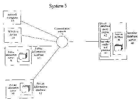
A person using a computer network, operates network computer 10 that consists
of a
RAM, ROM, a display (not shown) and programmable media upon which computer
readable code may be generated, transmitted, recorded, manipulated or stored
as a
12
CA 02342030 2001-03-23
memory (not shown), for example, of the type sold by IBM~ of Armonk, New York,
logs
on to a computer network system 5. The person could also interact with the
computer
network by way of wireless device 20, such as a mobile phone or PDA. He or she
could
also use an Internet appliance, which is any device that interacts with the
Internet. In the
preferred embodiment of the invention, the computer network system 5 is the
Internet.
However, as will be apparent to those skilled in the art computer network
system 5 could
be any computer network consisting of at least two computers, such as a local
area
network, a wide area network, an intranet or a virtual private network. The
computer
network user creates or compiles information relating to wares, services,
events or other
objects that are available or located within a specified geographic area or
have some
relevant geographic context. This information can include content, such as a
name,
narrative description of the thing, other text, graphics, hyper-links to web
pages or other
content, instructions to start a computer application or any other information
of potential
interest. The computer network user submits the information along with an
indication
of its location, such as a civic address, via communication network 15 to a
location
database server 40. Alternately, the computer network user submits only an
indication
of location. Communication network 15 may consist of data transmission lines,
routers
and servers as are known to those skilled in the art.
Location database server 40 is a computer network server that consists of a
RAM, ROM,
display, etc. (not shown) and programmable media upon which computer readable
code
maybe generated, transmitted, recorded, manipulated or stored as a memory (not
shown),
for example, of the type sold by IBM~ of Armonk, New York. Location database
server
40 also contains a data base query engine 42, a location data base 46, such as
the object-
relational hybrid database described above, and a key/index verifier and
generator 44.
The key/index verifier and generator 44 includes a transition network parser,
of the sort
described in Luger, G. F. and Stubblefield, W. A., "Artificial Intelligence,
Structures and
Strategies for Complex Problem Solving", 2nd Edition, The Benjamin/Cummings
Publishing Company, Inc., 1993, pp. 403-407, as is known to those skilled in
the art. The
key/index verifier and generator 44 receives the indication of location, such
as street
address, and parses it into its constituent parts and organises it into a
format that is used
-13-
CA 02342030 2001-03-23
by the location database 46. The key/index verifier and generator 44 then
submits the
parsed indication of location to the location database 46 to determine if it
is an indication
of location for which a unique key or index entry may be generated and
returned.
If the parsed indication of location provided by the computer network user is
identified
as a valid indication of location and a unique key or index entry has been
created already
for this valid addressable location, then the unique key or index entry and
associated
content are incorporated into the location database 46 and made available and
accessible
to those computer network users searching for information relating to wares,
services,
events, or other objects of interest that are available within a specified
geographic area.
If the parsed indication of location provided by the computer network user is
identified
as a valid addressable location and a unique key or index entry has not been
created for
this valid addressable location, then the key/index verifier and generator
generates a
unique key or index entry, as described above, for this valid addressable
location. This
can be done in two ways. First, the latitude-longitude for this addressable
location could
be obtained from some other database. Alternatively, if the latitude-longitude
values are
known for at least two nearby addressable locations, the latitude-longitude of
this
addressable location could be determined by interpolation. The unique key or
index entry
and the associated content are then incorporated into the location database 46
and made
available and accessible to those computer network users searching for
information
relating to wares, services, events, or other objects of interest that are
available within the
specified geographic area.
If the parsed indication of location provided by the computer network user is
not
identified as a valid addressable location, the key/index verifier and
generator 44 returns
an error message to network computer 10 via communication network 15,
informing the
computer network user that the location information provided does not
correspond to a
valid addressable location. In an alternate embodiment of the invention, the
key/index
verifier and generator 44 may send suggestions to network computer 10 via
network
-14-
CA 02342030 2005-09-02
communication 15 outlining steps that the computer network user may take to
correct the
error. In a further alternate embodiment, the key/index verifier and generator
may
generate a list of possible valid addressable locations based on the
information provided
and send this list to network computer 10 via communication network 15. In
response,
the computer network user may select the correct address from the list
provided, or
submit further location information to the key/index verifier and generator
44.
In an alternate embodiment, the computer network user may not wish to have the
unique
key or index and associated content registered with the location database 46.
The
computer network user may use the unique key or index to tag or associate with
the data
that he or she intends to make publicly available. In the preferred
embodiment, the unique
key or index is incorporated in to the meta data of a web page and is
available as a search
target for computer network users searching for this sort of geographically
specific data.
In this embodiment, location sensitive data is tagged or associated with the
unique key,
but it does not have to be stored on a location database server. The combined
location
sensitive data and unique key may be stored in any database that supports this
data-type.
In a fiuther alternate embodiment, the computer network user may use the
unique key or
index to tag or associate with data that is not publicly available, access to
which is
restricted to authorised computer network users/individuals. The unique key or
index can
then be used to enable spatial analysis of the computer network user's data.
However, the
spatial analysis function done within the location database server 46 itself.
GIS
functionality doesn't reside in computer network user's database. In an
alternate
embodiment, a location database and GIS functionality resides on computer
network
user's computer. The computer network user provides at least one unique key
and a
location sensitive search request to the location database server 46 via
network
communication 15.
A Computer Network User Searching for Location Sensitive Data:
CA 02342030 2001-03-23
The unique key enables spatial analysis. A unique key can be located at the
computer
network user's computer, location database server 46 or anywhere else on the
Internet.
By being able to interact with the unique key or index, the computer network
user can
conduct sophisticated GIS functionality such as spatial analysis without
having to acquire
a high level of expertise in GIS systems and without having to export
sensitive and
proprietary data to a GIS provider.
A person using a computer network, operates network computer 10 that consists
of a
RAM, ROM, a display (not shown) and programmable media upon which computer
readable code may be generated, transmitted, recorded, manipulated or stored
as a
memory (not shown), for example, of the type sold by IBM~ of Armonk, New York,
logs
on to a computer network system 5. The person could also interact with the
computer
network by way of wireless device 20, such as a mobile phone or PDA. They
could also
use an Internet appliance, which is any device that interacts with the
Internet. In the
preferred embodiment of the invention, the computer network system 5 is the
Internet.
However, as will be apparent to those skilled in the art computer network
system 5 could
be any computer network consisting of at least two computers, such as a local
area
network, an intranet or a virtual private network. The computer network user,
searching
for information relating to wares or services that are available within a
specified
geographic area, creates a query specifying search criteria, such as ware,
service, event,
delivery area and location. In an alternate embodiment of the invention, the
computer
network user may be searching for information relating to wares or services
that are
available relative to his or her present physical location.
In this case, prior to generating and submitting a location sensitive query to
the location
database server 40, the computer network user submits information relating to
his or her
present physical location to the location database server 40. If the user is
in a static
location, such as a house, apartment building, shopping mall, sports arena,
etc., the
computer network user can submit the address of this static location to the
location
database server 40 and in return receive the unique key or index of the
address. If
however, the computer network user is operating a mobile communication device,
such
-16-
CA 02342030 2005-09-02
as a mobile phone or wireless PDA, which employs a positioning technology by
which
the location of the wireless device 20 can be detected, and the computer
network user is
not located in a static location, the mobile communication device 20 can
transmit the
computer network user's positioning information to the location database
server 40 and in
return receive the unique key or index that corresponds most closely to the
transmitted
position information.
This location sensitive query is transmitted via communication network 15 to
location
database server 40. Communication network 15 may consist of data transmission
lines,
routers and servers as are known to those skilled in the art. Location
database server 40 is
a computer network server that consists of a RAM, ROM, display, etc. (not
shown) and
programmable media upon which computer readable code may be generated,
transmitted,
recorded, manipulated or stored as a memory (not shown), for example, of the
type sold
by IBM® of Armonk, N.Y. Location database server 40 also contains a data
base
query engine 42, location data base 46 and key/index verifier and generator
44. Database
query engine 42 receives the computer network user's query and queries
location database
46 for records that match the search criteria. The records that match the
search criteria are
then sent to computer 10 via communication network 15.
In an alternate embodiment of the invention, a public information database
server 50
stores the unique key or index and location sensitive information in a public
information
database 52, access to which is open to all computer network users.
In a further alternate embodiment of the invention, a private information
database server
60 stores the unique key or index and location sensitive information in a
private
information database 62, access to which is restricted to authorised computer
network
users.
In the preferred embodiment of the invention, the search result is returned in
the form of
a visual display consisting of a map of the geographic area of interest as
well as icons that
represent the real world location of the records that match the user's search
criteria and
17
CA 02342030 2001-03-23
the category of the item that is being sought. In an alternate embodiment, the
search
result may be sent in a non-graphic format that satisfies the spatially
related query. For
example, the search result may be in the form of a text list of the abstract
locations.
The size, shape, colour and other attributes of the icons are defined by the
database
developer. In an alternate embodiment of the invention the attributes of the
icon are
defined by the user searching for location specific information, the web
master, the web
developer, etc... The user is then able to click on these icons and receive
more
information relating to the item that matched the search criteria. In another
alternate
embodiment of the invention, the icon may function as a communication link
that will
link the user to a web page that will provide more information about the item
being
sought. In a further embodiment, the user may click on the icon that in
response executes
a start command for a computer application.
A method for generating a unique key or index will now be discussed with
reference to
the flowchart of Figure 3 and system S. W the preferred embodiment of the
invention,
the method described in Figure 3 is commenced on a location database server 40
receiving an indication of location. The location database server can be
enabled by a
computer program product, comprising a memory having computer-readable code
embodied therein for generating a unique key or index including a code means
for
receiving an indication of location; determining a latitude - longitude value
corresponding
to the received indication of location; generating at least one other piece of
data in
addition to the latitude-longitude value; and, combining the determined
latitude -
longitude value and the at least one other piece of data to form a unique key.
At step
3010, this information consists, by way of example, of a civic address, such
as 199 Bay
St., Toronto, Ontario Canada, a geographic area, such as a city neighbourhood
or any
abstract location, such as an event. At step3020 a latitude - longitude value
corresponding to the received indication of location is determined. Once the
latitude -
longitude value is determined, then at step 3030 at least one other piece of
data is
generated, such as a time stamp, which is any time stamp determined at a
consistent time
within the steps of the method (e.g., the time that the latitude-longitude
value was
-18-
CA 02342030 2001-03-23
determined or the time that the request for the unique key was made) or a
sequence
number. At step 3040, the latitude - longitude and the at least one other
piece of data are
combined to form a single unique key or index, which is in a form that is
easily
understood by a computer, such as a hexadecimal format.
A method for searching for processing a location sensitive search request for
a specified
geographic area will now be discussed with reference to the flowchart of
Figure 4 and
system 5. In the preferred embodiment of the invention, the method described
in Figure
4 is commenced on receiving a location sensitive search request from a network
computer
10. At step 4010 this information consists of a location information
component, a
description of the item, service, or material of interest and a description of
the geographic
area of interest. The location information component of the location sensitive
search is
then parsed into a format that is used by a location database (step 4020). At
step 4030,
a database query engine queries a location database 46 for records that match
the location
sensitive search request. A list consisting of the search results that satisfy
the location
sensitive search request is then generated at step 4040 and transmitted to the
network
computer 10 (step 4050).
A method for creating a unique key or index and processing a location
sensitive search
request with a static location as a reference point will now be discussed with
reference
to the flowchart of Figure 5 and system 5. In the preferred embodiment of the
invention,
the method described in Figure 5 is commenced on receiving an indication of
the location
of a static reference point and a location sensitive search request from a
network
computer 10 (step 5010). At step 5020 a latitude - longitude value
corresponding to the
indication of location of the static reference point is determined. Once the
latitude -
longitude value is determined, then at step 5030 at least one other piece of
data is
generated, such as a time stamp, which is any time stamp determined at a
consistent time
within the steps of the method (e.g., the time that the latitude-longitude
value was
determined or the time that the request for the unique key was made) or a
sequence
number. At step 5040, the latitude - longitude and the at least one other
piece of data are
-19-
CA 02342030 2001-03-23
combined to form a single unique key or index, which is in a form that is
easily
understood by a computer, such as a hexadecimal format.
A database query engine 42 queries a location database 46, with the unique key
as a
reference point, for records that satisfy the location sensitive search
request (step 5050).
The search results that satisfy the location sensitive search request are then
generated at
step 5060 and at step 5070 transmitted to the network computer 10.
A method for creating a unique key or index and processing a location
sensitive search
request with a mobile location as a reference point will now be discussed with
reference
to the flowchart of Figure 6 and system 5. In the preferred embodiment of the
invention,
the method described in Figure 6 is commenced on receiving positioning
information of
a mobile reference point and a location sensitive search request from a
wireless device
(step 6010). At step 6020 the nearest static location that corresponds to the
position
15 of the wireless device 20 is determined. A latitude - longitude value
corresponding to the
nearest static location is then determined at step 6030. Once the latitude -
longitude value
is determined, then at step 6040 at least one other piece of data is
generated, such as a
time stamp, which is any time stamp determined at a consistent time within the
steps of
the method (e.g., the time that the latitude-longitude value was determined or
the time
20 that the request for the unique key was made) or a sequence number. At step
6050, the
latitude - longitude and the at least one other piece of data are combined to
form a single
unique key or index, which is in a form that is easily understood by a
computer, such as
a hexadecimal format.
A database query engine 42 queries a location database 46, with the unique key
as a
reference point, for records that satisfy the location sensitive search
request (step 6060).
The search results that satisfy the location sensitive search request are then
generated at
step 6070 and at step 6080 transmitted to the wireless device 20.
A method for processing a location sensitive search request from a device for
which a
unique key, which acts as a reference point for the search, has been assigned
already will
-20-
CA 02342030 2001-03-23
now be discussed with reference to the flowchart of Figure 7 and system 5. In
the
preferred embodiment of the invention, the method described in Figure 7 is
commenced
on receiving a unique key and a location sensitive search request from a
network
computer 10 (step 7010). A database query engine 42 queries a location
database 46, with
the unique key as a reference point, for records that satisfy the location
sensitive search
request (step 7020). The search results that satisfy the location sensitive
search request
are then generated at step 7030 and at step 7040 transmitted to the network
computer 10.
A method for conducting a location sensitive search request will now be
discussed with
reference to the flowchart of Figure 8 and system S. In the preferred
embodiment of the
invention, the method described in Figure 8 is commenced on a network computer
generating a location sensitive search request (step 8010). The network
computer may
be enabled by a computer program product, comprising a memory having computer-
readable code embodied therein for conducting a location sensitive search that
includes
a code means for generating a location sensitive search request; submitting
the location
sensitive search request to a location database server; receiving a search
result from the
location database server; and, displaying the search result. At step 8010, the
location
sensitive search request consists of a description of the item, service, or
material of
interest and a description of the geographic area of interest or some other
geographic
context. The location sensitive search request is then submitted to a location
database
server 40 in step 8020. At step 8030, a network computer 10 or wireless 20
receives a
search result from the location database server 40. The search results are
displayed in a
display of the network computer 10 or wireless device 20 at step 8040.
A method for conducting a location sensitive search with a static location as
a reference
point will now be discussed with reference to the flowchart of Figure 9 and
system 5. In
the preferred embodiment of the invention, the method described in Figure 9 is
commenced on generating a location sensitive search (step 9010). At step 9020
an
indication of the static location that acts as the reference point for the
location sensitive
search is generated. The location sensitive search request and the indication
of static
location are then submitted to a location database server 40 at step 9030. At
step 9040
-21-
CA 02342030 2001-03-23
a network computer 10 receives a unique key or index that corresponds to the
position
of the indication of static location and or the search results of the location
sensitive search
request from location database server 40. The search results and or relative
location of
the unique key or index are then displayed on a display of the network
computer 10 at
step 9050.
A method for conducting a location sensitive search with a mobile location as
a reference
point will now be discussed with reference to the flowchart of Figure 10 and
system 5.
In the preferred embodiment of the invention, the method described in Figure
10 is
commenced on generating a location sensitive search request (step 10010). At
step
10020 an indication of the mobile location of a wireless device 20, which acts
as the
reference point for the location sensitive search, is generated. The location
sensitive
search request and the indication of mobile location of the wireless device 20
are then
submitted to a location database server 40 at step 10030. At step 10040, the
wireless
device 20 receives, from the location database server 40, a search result of
the location
sensitive search request. The search result is displayed on a display of the
wireless device
at step 10050.
A method for creating location sensitive data and transmitting it to a
location database
20 server will now be discussed with reference to the flowchart of Figure 11
and system 5.
In the preferred embodiment of the invention, the method described in Figure
11 is
commenced on creating or compiling information relating to an item, service,
event of
interest or any other location sensitive information (step 11010). At step
11020, an
indication of location for the information relating to the item, service,
event of interest
or any other location sensitive information is generated. Then, the indication
of location
and the information relating to the item, service, event of interest or any
other location
sensitive information is transmitted to a location database server (step
11030). At step
11040 a response is received from the location database server. The response
from the
location database server may be a unique key that corresponds to the submitted
information relating to the item, service, event of interest or any other
location sensitive
information and the indication of location to a database server. Alternately,
if an invalid
-22-
CA 02342030 2001-03-23
indication of location was sent to the location database server, then the
response may
consist of an error message. The error message may also include suggestions
for
correcting the error or a list of alternative indications of locations for
which a unique key
may be generated.
A method for creating location sensitive data that is stored in a location
other than a
location database server will now be discussed with reference to the flowchart
of Figure
12 and system 5. In the preferred embodiment of the invention, the method
described in
Figure 12 is commenced on creating or compiling information relating to an
item,
service, event of interest or any other location sensitive information (step
12010). At step
12020, an indication of location for the information relating to the item,
service, event
of interest or any other location sensitive information is generated. Then,
the indication
of location and the information relating to the item, service, event of
interest or any other
location sensitive information is transmitted to a location database server
(step 12030).
At step 12040 a unique key that corresponds to the submitted indication is
returned. This
unique key is then associated with the information relating to an item,
service, event of
interest or any other location sensitive information (step 12050). At step
12060, a
database entry with the unique key and associated information relating to an
item, service
or event of interest is created.
A method for receiving and storing location sensitive data for which a unique
key exists
will now be discussed with reference to the flowchart of Figure 13 and system
5. In the
preferred embodiment of the invention, the method described in Figure 13 is
commenced
on receiving information relating to an item, service, event of interest or
other location
sensitive data and an indication of the location of said location sensitive
data (step
13010). At step 13020, the indication of location is parsed into a format used
by a
location database. Once the indication of location is parsed, then a
determination is made
of whether a unique key may be generated for the parsed indication of location
step
13030. At step 13040 database query engine queries the location database for
the
existence of a unique key for the parsed indication of location. The unique
key with the
-23-
CA 02342030 2001-03-23
location sensitive data (step 13050) and a database entry for the combined
unique key and
location sensitive data is created (step 13060).
A method for receiving and storing location sensitive data for which a unique
key does
not exist will now be discussed with reference to the flowchart of Figure 14
and system
5. In the preferred embodiment of the invention, the method described in
Figure 14 is
commenced on receiving information relating to an item, service, event of
interest or
other location sensitive data and an indication of the location of said
location sensitive
data (step 14010). At step 14020, the indication of location is parsed into a
format used
by a location database. Once the indication of location is parsed, then a
determination
is made of whether a unique key may be generated for the parsed indication of
location
step 14030. At step 14040 database query engine queries the location database
for the
existence of a unique key for the parsed indication of location. At step 14050
a latitude -
longitude value corresponding to the received indication of location is
determined. Once
the latitude - longitude value is determined, then at step 14060 at least one
other piece of
data is generated, such as a time stamp, which is any time stamp determined at
a
consistent time within the steps of the method (e.g., the time that the
latitude-longitude
value was determined or the time that the request for the unique key was made)
or a
sequence number. At step 14070, the latitude - longitude and the at least one
other piece
of data are combined to form a single unique key or index, which is in a form
that is
easily understood by a computer, such as a hexadecimal format. The unique key
with the
location sensitive data (step 14080) and a database entry for the combined
unique key and
location sensitive data is created (step 14090).
A method for returning an error message upon receipt of invalid indication of
location
will now be discussed with reference to the flowchart of Figure 15 and system
5. In the
preferred embodiment of the invention, the method described in Figure 15 is
commenced
on receiving information relating to an item, service, event of interest or
other location
sensitive data and an indication of the location of said location sensitive
data (step
15010). At step 15020, the indication of location is parsed into a format used
by a
location database. Once the indication of location is parsed, then a
determination is made
-24-
CA 02342030 2001-03-23
of whether a unique key may be generated for the parsed indication of location
step
15030. At step 15040 an error message is generated, comprising at least one of
a list of
suggestions for correcting the error or a list of alternative indications of
location for
which a unique key may be generated. The error message is then transmitted to
a
computer network user (step 15050).
Those skilled in the art will recognize that there are many equivalent
embodiments of the
invention described above. The scope of the invention is defined in the
claims, set out
below.
-25-