Note: Descriptions are shown in the official language in which they were submitted.
CA 02364888 2001-12-07
A METHOD AND SYSTEM FOR COMPLETE 3D OBJECT AND AREA
DIGITIZING
BACKGROUND OF THE INVENTION
Several systems for generating computer models of objects, scenes, or terrain
are known
including those disclosed in United States Patent Nos. 6,094,269 (Den-Dove, et
al.);
5,513,276 (Theodoracatos); and, 5,497,188 (Kaye). These systems scan the
surface of an
object with a laser and digital camera combination to produce a wire-frame, or
raster
model for later testing or simulation purposes. Other systems may use a laser
and video
camera to gather 3D images for virtual reality applications. Thus, 3D
measurements may
be taken and digital images captured with the objective of producing a non-
life-like 3D
model or a life-like 3D model constructed with "real" digital images. In the
non-life-like
3D case, the digital camera is. used primarily to establish 3D coordinates in
conjunction
with a laser. In the life-like "real" image 3D model, the digital camera is
used to both
establish 3D coordinates and to record actual images which will be
incorporated in the
resultant model.
One shortcoming of the current systems is their inability to produce models of
objects,
scenes, and terrain that vary widely in size. Most known systems focus on
either small-
scale object modelling or very large-scale terrain mapping or scene modelling.
These
known systems are not flexible enough for applications demanding wide
variations in the
size of the subject matter for which a model is desired. This is especially so
for systems
that attempt to produce "real" image 3D models.
1
CA 02364888 2001-12-07
A need therefore exists for a method, system, and apparatus that will allow
for the
effective "real" image 3D modeling of subject matter that can vary widely in
size.
Consequently, it is an object of the present invention to obviate or mitigate
at least some
of the above mentioned disadvantages.
SUMMARY OF THE INVENTION
The invention provides a system and apparatus for scanning areas and objects
of varying
size.
In accordance with this invention there is provided a method for acquiring
visual
information of an object, the method comprises a survey grid at a selected
location,
acquiring data points using a predetermined survey plan of the site,
calculating 3D
coordinates at the acquired data points, and subsequently post-processing this
data for use
by a variety of software applications. Accordingly, "real" 3D images of a
target object or
area can be collected and stored so that a user may subsequently regenerate
and view
images of the target object or area from any viewpoint via a computer and
display.
According to another aspect of the invention, there is provided an apparatus
for
generating a three-dimensional data model of a surface comprising a data
acquisition
apparatus for scanning a surface to record digital images thereof and means
for
determining three-dimensional coordinates thereof.
The data acquisition apparatus comprises: at least one camera for recording
digital
images of the surface, the camera having an optical axis; at least two lasers
for marking
points in the digital images for determining the three dimensional coordinates
of the
2
CA 02364888 2001-12-07
surface, the lasers having optical axes, the optical axes of camera and lasers
being
substantially parallel; a rail for mounting the camera and lasers, the camera
being
mounted between the lasers, and the rail having means for moving the camera
and lasers
along the rail; at least one post extending from the rack and attached to the
rail by a
means for rotating and horizontally shifting the rail, the post having means
for shifting
the rail; at least one moveable platform for mounting the posts and for
positioning the
camera and lasers proximate to the surface; and, data acquisition equipment
for adjusting
the platforms, the posts, the rail, the camera, and the lasers, for recording
position data for
the platforms, the posts, the rail, the camera, and the lasers, and, for
recording the digital
images.
According to another aspect of the invention, a data acquisition system is
provided for
generating a three-dimensional data model of a surface. This data processing
system has
stored therein data representing sequences of instructions which when executed
cause the
method described herein to be performed. The data processing system comprises:
a data
acquisition apparatus for scanning said surface to record digital images
thereof and to
record data for determining three-dimensional coordinates thereof; and, a data
acquisition
computer system in communication with the data acquisition apparatus. The data
acquisition computer system comprises: means for adjusting the data
acquisition
apparatus in accordance with user instructions; means for receiving position
data and
digital images from the data acquisition apparatus; means for determining
three-
dimensional coordinates of the surface from the position data and the digital
images;
means for associating the digital images with the three-dimensional
coordinates to
produce a three-dimensional data model; memory for storing position data,
digital
3
CA 02364888 2001-12-07
images, three-dimensional coordinates, and the three-dimensional data model; a
display
for presenting the three-dimensional data model to the user; and, an input
device for
accepting user instructions from the user for adjusting the data acquisition
apparatus.
According to another aspect of the invention, a method is provided for
generating a three-
dimensional data model of a surface. The method comprises the steps of
selecting data
parameters for the three-dimensional data model; configuring a data
acquisition system
corresponding to the data parameters, wherein the data acquisition system
comprises a
data acquisition apparatus and a data acquisition computer system; scanning
the surface
with the data acquisition system to obtain digital images of the surface and
position data
for determining three-dimensional coordinates of the surface; determining the
three-
dimensional coordinates of the surface from the position data and the digital
images;
associating the digital images with the three-dimensional coordinates to
produce the
three-dimensional data model; and, storing the three-dimensional data model in
the data
acquisition system.
BRIEF DESCRIPTION OF THE DRAWINGS
The invention may best be understood by referring to the following description
and
accompanying drawings which illustrate the invention. In the drawings:
FIG. 1 is a simplified perspective view illustrating a single laser-camera
scanning system
in accordance with one embodiment;
FIG. 2 is a perspective view illustrating the location of a single laser beam
scan on a
portion of a scene in accordance with one embodiment;
4
CA 02364888 2001-12-07
FIG. 3 is a detail perspective view illustrating the laser beam path from the
viewpoint of
the camera of the laser bean scan of FIG. 2 in accordance with one embodiment;
FIG. 4 is a perspective view of a survey grid in accordance with the preferred
embodiment;
FIG. 5 is a decision tree diagram for planning a survey in accordance with the
preferred
embodiment;
FIG. 6(a) is a schematic diagram illustrating the direction of an interior
scan in
accordance with the preferred embodiment;
FIG. 6(b) is a schematic diagram illustrating the direction of an exterior
scan in
accordance with the preferred embodiment;
FIG. 7 is a front view illustrating a data acquisition apparatus for large-
scale surveys in
accordance with the preferred embodiment;
FIG. 8 is a front view illustrating a data acquisition apparatus for small and
medium-scale
surveys in accordance with the preferred embodiment;
FIG. 9(a) is a block diagram of a data acquisition computer system for
implementing the
method and controlling the data acquisition apparatus of the present invention
in
accordance with one embodiment;
FIG. 9(b) is a schematic diagram of data acquisition computers configured as a
web
network in accordance with one embodiment;
5
CA 02364888 2001-12-07
FIG. 10 is a perspective view of a camera's field of vision cone in accordance
with the
preferred embodiment;
FIG. 11 is a diagram illustrating calibration plate quadrants in accordance
with the
preferred embodiment;
FIG. 12 is a schematic diagram illustrating a horizontal (non-rotated)
laser/camera group
in accordance with the preferred embodiment;
FIG. 13 is a schematic diagram illustrating a non-horizontal (rotated)
laser/camera group
in accordance with the preferred embodiment;
FIG. 14 is a diagram illustrating a calibration plate with movement of a laser
across the
photograph for equal changes in distance to the target in accordance with the
preferred
embodiment;
FIG. 15 is a diagram illustrating laser scanning ranges in accordance with the
preferred
embodiment;
FIG. 16 is a table listing camera viewpoint angle degrees, distance centre-
line to
viewpoint, and distance normalized for an example case in accordance with the
preferred
embodiment;
FIG. 17(a) is a table listing L, distance b, ratio a/(a+b), and number of
pixels from the
centre line (CL), for an example case, in accordance with the preferred
embodiment;
6
CA 02364888 2001-12-07
= FIG. 17(b) is a graph illustrating the relationship between the distance to
a target and the
distance from the centre of a photograph for an example case in accordance
with the
preferred embodiment; and,
FIG. 18 is a flow chart illustrating a general method for collecting survey
data including
digital images and associated 3D coordinates for use in generating "real"
image 3D
computer models of subject matter of varying size in accordance with a
preferred
embodiment.
DETAILED DESCRIPTION OF THE PREFERRED EMBODIMENTS
In the following description, numerous specific details are set forth to
provide a thorough
understanding of the invention. However, it is understood that the invention
may be
practiced without these specific details. In other instances, well-known
software, circuits,
structures and techniques have not been described or shown in detail in order
not to
obscure the invention. The terms "data acquisition computer system" and "post-
processing computer system" are used herein to refer to any machine for
processing data,
including the computer systems and network arrangements described herein. The
term
"real" image 3D model. is used herein to refer to a computer generated model
that
incorporates actual images captured by a digital camera. In the drawings, like
numerals
refer to like structures or processes.
The invention described herein provides a method, system, and apparatus for 3D
scanning, acquiring and locating "real" visual information, storing this
information with
3D coordinates, and processing this information for use in a wide variety of
applications.
The invention provides a system and apparatus for scanning areas and objects
of any size.
7
CA 02364888 2001-12-07
The method of the present invention includes establishing a survey grid at a
selected site,
acquiring data using a predetermined survey plan and a data acquisition
apparatus,
calculating 3D coordinates, and subsequently post-processing this data so that
it can be
utilized by a variety of software applications. With the method, system, and
apparatus of
the present invention "real" 3D images from a target object or area can be
collected and
stored so that a user may subsequently regenerate and view images of the
target object or
area from any viewpoint scanned by the apparatus via a computer and display.
In general, it is not possible to determine the 3D coordinates of objects
within a
photograph without an external reference point. Typically, a laser beam offset
from the
position of the camera is used to provide such a reference point. Referring to
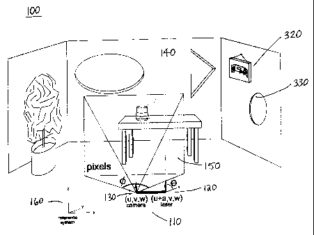
FIG. 1,
there is shown a simplified perspective view 100 illustrating a single
laser/camera data
acquisition apparatus 110 in accordance with one embodiment of the invention.
The
single laser/camera data acquisition apparatus 110 includes a laser 120 and a
camera 130
which are directed toward a scene 140 a portion 150 of which is to be scanned
and
photographed to produce a "real" image 3D computer model. In FIG. 1, the scene
140 is a
room in a house. Both the laser 120 and camera 130 are directed parallel to
each other
along the y-axis of a reference coordinate system 160.
Referring to FIG. 2, there is shown a perspective view 200 illustrating the
location of a
single laser beam scan 210 on a portion 150 of a scene 140 in accordance with
one
embodiment of the invention. Referring to FIG. 3, there is shown a detail
perspective
view 300 illustrating the laser beam path 310 from the viewpoint of the camera
130 of the
laser bean scan 210 of FIG. 2, in accordance with one embodiment of the
invention. FIG.
3 is close-up view of the beam path 210 shown in FIG. 2. FIG. 3 illustrates
the apparent
8
CA 02364888 2001-12-07
shift in the laser point of impingement 320, 330 from the viewpoint of the
camera 130.
This apparent shift depends on the distance to the impinged object or scene
320, 330. By
locating the position of the laser 120 on the scanned image or photograph 150,
it is
possible to determine the 3D coordinates of the impinged object 320, 330. This
process is
described in United States Patent No. 5,753,931 (Borchers, et al.).
Method. Referring to FIG. 18, there is shown a flow chart 1800 illustrating a
general
method for collecting survey data including digital images and associated 3D
coordinates
for use in generating "real" image 3D computer models of subject matter of
varying size
in accordance with a preferred embodiment of the invention. At step 1801, the
method
starts. At step 1802, the goal of the survey is defined. At step 1803, a
survey plan is
produced. At step 1804, a data acquisition system is configured to conduct the
survey. At
step 1805, the survey is conducted using the data acquisition system and data
is collected
and stored. At step 1806, post-processing is conducted on the data by a post-
processing
computer system to prepare the data for use by external client applications.
At step 1807,
post-processed data is exported to and used by external client applications.
At step 1808,
the method ends.
Below, a detailed description of the method, system, and apparatus of the
present
invention is provided under the following headings:
= Defining the Survey Goal
= Producing a Survey Plan
= Configuring the Data Acquisition System
9
CA 02364888 2001-12-07
= Conducting the Survey
= Post-Processing the Data
= Applying the Data
Defining the Survey Goal. Prior to beginning a survey, the goal or purpose of
the survey
is established. Setting the right goal can reduce survey time and cost because
the survey
can be carried out with optimal settings. For example, if the goal of a large
scale interior
survey of a stadium is to allow a computer game to provide a realistic view of
the
stadium from the viewpoint of players on the field, then it may not be
necessary to scan
details of each and every seat, from positions above, behind and below each
seat, in the
entire stadium. On the other hand, if a crime scene is to be transferred to an
investigator's
computer for further analysis, then the amount of scanning detail required
would need to
be quite high, especially if the clue being sought is not known prior to
scanning. In
general, it may be better to acquire too much data rather than too little as
the time and
expense to revisit a site may be significant and restrictive. Moreover, the
final scan
product can be filtered to contain only the data required.
Producing a Survey Plan. After the goal has been determined, the survey can be
planned. Referring to FIG. 5, there is shown a decision tree 500 for planning
a survey in
accordance with the preferred embodiment. The scope of the survey is
determined by
parameters including scanning resolution, detail, accuracy, time, budget,
scale, and site
access. These parameters may be interrelated. For example, low budgets may
make it
undesirable to attain a high scanning resolution. Site access restrictions may
prevent
CA 02364888 2001-12-07
detail from being achieved in restricted areas. If the goal of the survey is
to obtain
reconnaissance information, this will affect the specifications selected.
Mode. The first step in developing a survey plan is to select the scanning
mode. The
scanning mode can include an interior mode 510 and an exterior mode 520.
Exterior
scans may be referred to as `object' scans. Interior scans are outward looking
and can
include `object' scans as a sub-set of an overall site scan. Exterior scans
are inward
looking. For example, scanning all of the surfaces in a room involves pointing
the
scanning apparatus away from the inside of the room. On the other hand,
scanning an
object involves directing the scan towards the centre of the object from
outside the object,
Referring to FIG. 6(a), there is shown a schematic diagram 600 illustrating
the direction
of an interior scan. The direction 610 of the scan is away from centre 620.
Referring to
FIG. 6(b), there is shown a schematic diagram 630 illustrating the direction
of an exterior
scan. The direction 640 of the scan is towards centre 650.
A survey can be conducted at night or in the dark by using various spectral
technologies.
For example, infrared light can be used to acquire images without white light.
Scale. A next step in planning the survey is to select the overall size or
scale of the scan
530, 540. Overall scale can be divided into three subsets: large 550, 560,
medium 551,
561, and small 552, 562. Large-scale scans 550, 560 can be conducted for any
area or
object that can be "seen" by the system. That is, the laser beams (or spectral
sources)
must impinge on the surface being scanned and the camera (spectral or regular
visual)
must be capable of capturing the beams. Medium scale scans 551, 561 are for
areas and
objects that can be reached but some resolution may need to be sacrificed in
select
11
CA 02364888 2001-12-07
portions of the scene. Small-scale scans 552, 562 include areas and objects
that have the
highest degree of survey design flexibility given the various survey
constraints. For
example, a bullet found at a crime scene may need to be scanned at a super-
high
resolution to detect minute striations allowing its model to be "fired" using
a computer, in
super-slow-motion, thus allowing precise model studies.
Data Quality. The quality of measurements can depend on time and budget
limitations.
Typically, the optimal survey configuration that can achieve the goals set for
the survey,
in the shortest possible time and at the lowest cost, is the ideal
configuration. Data quality
can be selected from high 570, medium 571, and low 572 resolution, accuracy,
and/or
detail. Note that modern digital cameras are often compared in terms of
"megapixels"
rather than resolution. For example, a three-megapixel camera may be
considered as
better than a one-megapixel camera.
Compression and image stabilization methods may be used. Data compression may
be
used to "fine tune" the operation of the survey. Image stabilization methods
that allow
images to be acquired without degradation of picture quality may be used with
caution as
the positioning calculations, described below, must take into account any
"shifts" in
picture positioning caused by stabilizers.
Having planned the survey, the next step is to configure a system to implement
the
survey.
Configuring the Data Acquisition System. In order to conduct the planned
survey, a data
acquisition system must be configured and calibrated. It is preferable that
the data
acquisition system allows for adaptation to different survey scales and modes
as defined
12
CA 02364888 2001-12-07
by the survey plan. The data acquisition system includes a data acquisition
computer
system and at least one data acquisition apparatus. The data acquisition
computer system
controls the data acquisition apparatus and uses data acquisition equipment
associated
with the data acquisition apparatus to fulfil its instructions.
Data Acquisition Apparatus. According to one embodiment of the invention, the
data
acquisition system includes a data acquisition apparatus consisting of posts
and rails for
mounting cameras and lasers. This system can achieve high quality for small
objects (e.g.
baseball sized) and relatively high quality for large-scale surveys (e.g. a
stadium interior).
According to one embodiment of this data acquisition apparatus, components are
mounted on a rail that can be raised using extendable posts. This data
acquisition
apparatus can be transported via trucks, carts, ground rails, or hand.
Referring to FIG. 7, there is shown a front view 700 illustrating a data
acquisition
apparatus for large-scale surveys 710 in accordance with a preferred
embodiment of the
invention. For large-scale surveys, the data acquisition apparatus 710 can be
mounted on
trucks 720, 721, or other vehicles, so that greater heights and stability can
be achieved.
Various leveling and measurement systems, including off-the-shelf GPS (Global
Positioning System) and range-finding equipment, can be incorporated into the
data
acquisition apparatus 710 to assure accurate measurements. The rail 730 is
coupled to
each post 740, 741 by means for shifting and rotating 750, 751,'for example,
hydraulic or
electric actuators. Each post 740, 741 includes means for telescopic
adjustment 760, 761,
for example, hydraulic or electric actuators. The data acquisition apparatus
710 can be
dismantled for transportation. For example, the rail 730 may be composed of
sections 731
to facilitate disassembly and transport.
13
CA 02364888 2001-12-07
At least three cameras 771, 772, 773 can be used with each camera pointing in
one of the
following directions: forward (into paper) 771, reverse (out of paper) 772,
and up (above
trucks) 773. Laser clusters 780, 781 can be configured so that the beams from
at least one
pair of clusters 780, 781, located on either side of the cameras 770, 771,
772, are captured
by each one of the three cameras. The laser clusters 780, 781 are mounted on
the rail 730
on either side of the cameras 770, 771, 772. Each laser cluster 780, 781
includes at least
one laser. Each laser and laser cluster 780, 781 includes means for shifting
790, 791
along the rail 730, for example, hydraulic or electric actuators.
Each vehicle 720, 721 is equipped with data acquisition equipment 795. The
data
acquisition equipment 795 facilitates communication with a data acquisition
computer
system 900 which is described below. One of the vehicles 720, 721 can house
the data
acquisition computer system 900.
A laser/camera "group" is composed of at least one camera and two
corresponding laser
clusters. Typically, a laser/camera group consists of three cameras 770, 771,
772 and
hence six corresponding laser clusters. In this case, each camera 770 and its
two
corresponding laser clusters 780, 781 may be referred to as a laser/camera
"subgroup".
The camera and lasers of each subgroup point in the same direction as
described above:
The means for shifting and rotating 750, 751 along the rail 730 is used to
shift each
laser/camera group along the rail 730.
Note that the means for shifting and rotating 750, 751 is used for supporting,
shifting and
rotating the entire camera/laser group. The means for shifting along the rail
790, 791
includes means for varying parameters for each camera/laser subgroup. That is,
each
14
CA 02364888 2001-12-07
laser/camera subgroup can have different settings depending on the survey
site. For
example, if the data acquisition apparatus is located near a first building
wall in the
positive y-direction 160 which is to be scanned by a first laser/camera
subgroup and in
the negative y-direction a corresponding second building wall is located
somewhat
further away and which is to be scanned by a second laser/camera subgroup,
then a
greater "a-spacing", as described below, for the second laser/camera subgroup
can be
accommodated.
The data acquisition apparatus 710 including rail 730, posts 740, 741, cameras
771, 772,
773, laser clusters 780, 781, data acquisition equipment 795, means for
shifting and
rotating 750, 751 means for telescopic adjustment 760, and means for laser
shifting 790,
791 are responsive, generally through the data acquisition equipment 795, to a
data
acquisition computer system 900 which will be described in more detail below.
The data
acquisition computer system 900 stores data including the positions of the
trucks 720,
721 on an established grid, the location and rotational position of the
laser/camera group,
the spacing of individual lasers within each cluster (i.e. resolution
related), and the "a-
spacing" of the group (i.e. the distance between each camera and its
corresponding lasers
the significance of which will be described below). The data acquisition
computer system
900 also controls the survey speed and the rate at which photographs are
recorded.
Referring to FIG. 8, there is shown a front view 800 illustrating a data
acquisition
apparatus for small and medium-scale surveys 810 in accordance with a
preferred
embodiment of the invention. For small and medium-scale surveys, the data
acquisition
apparatus 810 can be mounted on a single cart 820 or platform. As with the
large-scale
apparatus 710, a data acquisition computer system 900 controls elements of the
data
CA 02364888 2001-12-07
acquisition apparatus 810 generally through the data acquisition equipment
795. A
"strobe" lighting system 830 can also be used if better lighting conditions
are required to
distinguish the laser beams from the surface being scanned.
Both trucks 920, 921 and carts 820 can be added in series to allow greater
scanning
depths by permitting the laser clusters 780, 781 to be located further away
from the
cameras 771, 772, 773. In this way, the data acquisition system may include
several data
acquisition apparatus. The combination data acquisitions apparatus can then be
transported along each survey grid line as will be discussed below.
Referring to FIG. 4, there is shown a perspective view 400 of a survey grid
410 in
accordance with the preferred embodiment of the invention. Each grid cell 420
represents
the possible location of a data acquisition apparatus 820. The width of the
grid cell 420 is
the same, or smaller to allow for overlap, as the laser/camera group's range
of motion
along the rail 730. The group moves along the rail 730 to its limit, like a
typewriter
carriage. The group is then "carriage-returned" as the whole cart 820 is moved
to the
next grid cell 420. Higher resolution can be achieved with smaller camera
movements
and tighter laser clusters. The reverse can be done for lower resolution. The
grid vertices
430 can be established at the survey site using physical markings (e.g. using
spray paint
outdoors, chalk indoors, etc.) or GPS (Global Positioning System) data.
An advantage of the vertical telescopic adjustment means 760, 761 is that it
prevents the
survey area 410 from becoming obscured. The rail 730, which includes means
750, 751
for laser/camera group rotation, is mounted on top of the posts 740, 741.
Guide wires, or
16
CA 02364888 2001-12-07
similar means, can be used to stabilize the data acquisition apparatus 710,
810, as
required.
Data Acquisition Computer System. Referring to FIG. 9(a), there is shown a
block
diagram of a data acquisition computer system 900 for implementing the method
and
controlling the data acquisition apparatus of the present invention in
accordance with one
embodiment. The data acquisition computer system 900 includes a computer
master node
910 controlling a cluster of parallel computer slave nodes 920. These
computers 910, 920
may be mounted in a rack. They may be networked in a number of ways,
including, but
not limited to cubes, hyper-cubes (i.e. cubes within cubes), meshes, and
layered webs.
The data acquisition computer system 900 may also include an input device,
memory,
and a display. The input device may be a keyboard, mouse, trackball, or
similar device.
The memory may include RAM, ROM, databases, or disk devices. And, the display
may
include a computer screen or terminal device. The data acquisition computer
system 900
has stored therein data representing sequences of instructions which when
executed
control the data acquisition apparatus and cause the method described herein
to be
performed. Of course, the data acquisition computer system 900 may contain
additional
software and hardware a description of which is not necessary for
understanding the
invention.
Referring to FIG. 9(b), there is shown a schematic diagram of data acquisition
computers
910, 920 configured as a web network 950 in accordance with one embodiment of
the
invention. Each layer of the web network can interact with another computer
node. The
connection between computers can be altered depending upon the survey plan.
For
example, if required, one computer from each layer can be connected directly
to the
17
CA 02364888 2001-12-07
master node 910. That is, nodes la and lb may be connected directly 930, 940
to the
master node 910. The 1-series of nodes controls each layer (i.e. nodes 1,
1(a), and 1(b)).
This provides better control of the individual layers from the master node.
Additional
layers can be added as required. In addition, the number of nodes per layer
may be
varied. In FIG. 9(b), there are 8 nodes per layer (e.g. nodes 1, 2, 3, 4, 5,
6, 7, and 8 are in
the first layer while nodes la, 2a, 3a, 4a, 5a, 6a, 7a, and 8a are in the
second layer).
Moreover, some nodes (960 in FIG. 9(a)) can function as backups to take over
in the
event of the failure of adjacent nodes.
An advantage of having several nodes connected to each other is to allow for
the "smart"
processing of data. For example, if a node that processes a particular laser
(e.g. node 5b)
acquires data that can not be used by another layer that processes its data
(e.g. too dark,
too much interference, etc.), then the system should decide whether it is
worth stopping
the process or continuing. The only way a decision like this can be made "on-
the-fly" is
to allow the interchange of error-checking variables between the nodes at all
times. If
enough relevant errors accumulate, then the software can calculate a
corrective course of
action, in real time, without manual intervention. For example, data
acquisition may
continue if the loss of one laser is not deemed to adversely effect the
resolution
requirements of the survey plan and if time limitations dictate that it is
more important
for the survey to proceed than to terminate.
Another advantage of a parallel-processing environment is that extremely large
amounts
of data can be acquired and stored at extremely high rates. Each computer node
carries
out specific tasks in parallel with each other computer node. Consequently,
the bottleneck
in the scanning process will be the mechanical systems used. For example, the
speed of
18
CA 02364888 2001-12-07
the cameras (i.e. number of photographs per second) and the speed by which the
laser/camera group can be moved or rotated along the rail, posts, and grid.
In the web network configuration of FIG. 9(b), the nodes in the outermost
layer of the
cluster (i.e. nodes 1b, 2b, 3b, 4b, 5b, 6b, 7b, and 8b) control the data
acquisition
apparatus 710, 810 (i.e. cameras 770, 771, 772, lighting 830, laser clusters
780, 781,
group shifting and rotating means 750, 751, telescopic adjustment means 760,
laser
sliding means 790, 791, etc.) These nodes can be located at the data
acquisition apparatus
710, 810 in the data acquisition equipment 795. This "b-series" of nodes
instructs
individual data acquisition apparatus subsystems to carry out specific tasks.
The b-series
also acts as the gateway for incoming data. This incoming data is passed from
the b-series
nodes to the "a-series" nodes of the next layer (i.e. nodes la, 2a, 3a, 4a,
5a, 6a, 7a, and
8a). The a-series cluster layer stores the data from the adjacent higher level
b-series node
layer with time stamps and grid coordinates of the different data acquisition
apparatus
subsystems (e.g. distance between laser clusters, distance between individual
lasers in
clusters, spectral values used for each cluster, group rotation/position,
etc). The "single-
digit" node layer (i.e. nodes 1, 2, 3, 4, 5, 6, 7, and 8) performs diagnostic
services,
synchronizes the clocks of all nodes, passes instructions regarding distances,
angles, light
intensity, etc., from the master node 910 to the higher node layers. The
master node 910
provides user input to all systems (e.g. via keyboard and display) and passes
instructions
to the various nodes to control the overall data acquisition system.
The data acquisition computer system 900 can make use of a wide variety of
parallel
processing application development tools including "PADE" (parallel
applications
development environment) and "XPVM" as well as code profiling tools such as
"Tau". A
19
CA 02364888 2001-12-07
number of parallel processing libraries are becoming more common hence making
parallel programming easier (e.g. "PAWS" (parallel application workspace) and
"POOMA" (parallel object-oriented methods and applications)). With the wide
spread
use of the Internet and access to Linux programming expertise, these and other
tools are
being used more often.
3D Data Coordinates: Dots and Stripes. As described above, the data
acquisition
apparatus 710, 810 includes laser clusters 780, 781 and cameras 770, 771, 772
mounted
on a rail 730. For data acquisition, the camera "pinhole" model can be used as
described
in United States Patent No. 4,979,815 to Tsikos. The height of the
laser/camera groups is
controlled with the telescopic adjustment means 760, 761. The distance between
the
individual lasers and between the laser clusters and cameras on the rail is
controlled by
the laser shifting means 790, 791. In the present invention, the laser "dot"
is always
located along the centre horizon of the photograph or scene/object to be
scanned. That is,
the laser is projected parallel to the optical axis of the camera.
A laser "stripe", pointing parallel to the camera direction, can also be used,
where discrete
segments of the stripe are equivalent to a series of laser dots with varying
angles above
and below the horizon. The laser stripe would also have unique solutions for
various
laser/camera a-spacings. Using a laser stripe may eliminate the need to rotate
the
laser/camera group. However, the use of laser stripes requires a relatively
large number
of calibrations and calculations to account for effects such as lens
distortion and offset
viewpoints. Employing laser stripes may be worthwhile if the time required to
rotate the
group through its normal range of motion is greater than the time required to
obtain
accurate laser stripe data.
CA 02364888 2001-12-07
A description of a method for obtaining 3D coordinates of "real" images from
lasers and
cameras in accordance with the preferred embodiment will now be provided.
3D Data Coordinates: Determining the Location of the Camera Focal Point and
the Field
of Vision Angle. In the present invention, images are acquired by a digital
camera. The
camera can operate in the human-visual or spectral (i.e. infra-red and other
remote-
sensing frequencies not visible to naked eye) ranges. The camera has to be
"calibrated"
so that the angles from the centre of the image to each pixel may be
determined.
Calibration tests can account for lens distortion and precision of the
instrumentation.
The camera "sees" an image within its field of vision, which is comparable to
the view
one would have looking through a hollow cone from the narrow end. Referring to
FIG.
10, there is shown a perspective view 1000 of a camera's field of vision cone
1010 in
accordance with the preferred embodiment. The total cone angle may be referred
to as 0
Note that an image is actually inverted 1020 within the camera 1030 prior to
being
transferred to the negative film or recording surface. While the focal point
1040 may be
located in the centre of the camera 1030, this is not always the case.
Therefore, it is
necessary to determine where the focal point 1040 of the camera 1030 is
located for the
specific lens 1050 being used.
To calculate the true focal point 1040, at least two calibration tests should
be made: one
at a distance M+N, where N is approximately equal to M, and another at a
distance N.
These distances may depend on the type of lens being used. A narrower angle
lens would
typically require larger distances (i.e. larger values of M and N) whereas a
wide-angle
lens may use require relatively small distances. Photographs obtained using
each such
21
CA 02364888 2001-12-07
lens would show two different vantage points for the same calibration plate.
The shift of a
certain point 1060 at the outer edge of the photograph may be represented the
variable O:
The value of 0 can be obtained by reading the shift off the calibration plate
1070. The
angle 412 can be determined with the following equation:
tan (412) = O/M (equation 1)
where 0 and M are both directly measurable from the calibration plate 1070.
It is important to use the outermost point 1080 useable on the furthest
photograph 1070,
so that the true field of vision can be used. The value L can be determined
with the
following equation:
tan (012) = PIL (equation 2)
where P and 0 12 are both known, P being measured directly from calibration
plate 1070.
From L the actual location of the focal point 1040 can then be determined.
Note that the values of 0 and P can be converted to pixels per metre. This may
be done
by counting the number of pixels on the photograph included in the distances
covered by
0 and P. These pixels per metre values will be required for laser related
calculations as
will be discussed below.
The calibration should be performed by the calibration plate 1070 at right
angles to the
direction of the camera 1030. Note that walls may be used as calibration
plates. Also, the
various calibration distances can be achieved by moving the group or data
acquisition
apparatus relative to the calibration plate. Referring to FIG. 11, there is
shown a diagram
22
CA 02364888 2001-12-07
illustrating calibration plate quadrants 1100 in accordance with the preferred
embodiment. Perpendicularity can be verified by calculating the angles from
all four
quadrants 1110, 1120, 1130, 1140 around the calibration plate 1070. For
perpendicularity, the angle #'2 should be equal, within a given tolerance, for
all four
quadrants 1110, 1120,1130,1140.
The camera viewpoint angles 1090 for each point within the camera frame can
also be
calibrated. Therefore, every "ring" 1170 within the calibrated frame has a
unique camera
viewpoint angle 1090. Referring to FIG. 16, there is shown a table 1600
listing camera
viewpoint angle ,v degrees 1610, distance centre-line to viewpoint 1620, and
distance
normalized (i.e. normalized such that P = 1 unit at ¾V2 = 29 degrees) 1630,
for the
example case where }V2 = 29 degrees and L = 1 m, in accordance with the
preferred
embodiment. Knowing these viewpoint angles 1090 is required for calculating
the
location of the laser reference point described below.
3D Data Coordinates: Laser Beams. From the above, the viewpoint angle portions
of an
acquired image can be determined. To determine 3D coordinates of points within
the
image, an additional reference point is required. A laser beam may provide
this additional
reference point.
Each laser beam should be conical-shaped so that the further away it is from
the data
acquisition apparatus, the wider the beam is. Therefore, the laser should be
of increased
energy for objects located at greater distances. The angle of the cone should
be chosen to
match the desired resolution. That is, features located further away may not
necessarily
require the same resolution as objects located nearby. If high resolution is
required for
23
CA 02364888 2001-12-07
objects located further away, then a smaller cone should be used and/or the
data
acquisition apparatus should be moved closer to the target.
Referring to FIG. 12, there is shown a schematic diagram 1200 illustrating a
horizontal
laser/camera group 1210 in accordance with the preferred embodiment. In FIG.
12, the
group 1210 consists of one camera 1030 and two lasers 1220, 1230. The method
of the
present invention involves the use of a laser 1230 located a fixed distance
"a" from the
camera 1030.
The laser 1230 points in a direction parallel to that of the camera 1030. In
other words,
and referring back to FIG. 1, 9y = 0 degrees. Note that distance a can be
varied
depending upon the site and system characteristics which will be discussed
below.
Using the calibration plate 1070, calibrations can be made to ensure that the
laser 1230
and camera 1030 directions are in the same plane and the focal point 1040 of
the camera
1030 and hinge point 1240 of the laser 1230 are at the same y-coordinate (160
in FIG. 1).
In FIG. 12, the point of impingement 1250 of the laser beam (i.e. the laser
dot) is located
in the vertical centre of quadrant II (1121 in FIG. 11). If the second laser
1220 was
calibrated, its point of impingement would be located in the vertical centre
of quadrant IV
(1141 in FIG. 11). It is important for the camera to be properly located and
directed with
respect to the calibration plates, as discussed above, and that the centre of
the photo is
identifiable by pixel coordinates.
Note that as the calibration plate 1070 is moved toward or away from the
camera 1030 in
the direction of the camera 1030 and laser 1230 (i.e. along the y-axis in the
coordinate
system 160 of FIG. 1), the laser 1230 points at exactly the same spot on the
calibration
24
CA 02364888 2001-12-07
plate 1070, that is, a metres from the centre-line 1260. However, the camera
1030 "sees"
the laser point 1250 moving towards the edge 1270 of the photograph 1280 as
the
calibration plate 1070 moves towards the laser/camera group 1210. If the
direction of the
laser is fixed at a different angle from the horizontal (i.e. if laser 1230
doesn't point in
same direction as camera 1030), then the laser point of impingement 1250 would
track at
an angle from horizontal on the calibration plate 1070 as the distance between
the plate
1070 and the apparatus changes. In the case where the laser direction is
parallel to the
camera direction, then the migration track of the laser beam from the vertical
centre 1290
can be used to check and calibrate the system as described below. It can be
shown that for
every identified laser point of impingement, the 3D coordinates of the
coinciding portion
of the image has a unique solution. In general, each calibration plate 1070 is
flat. While a
convex plate may seem more appropriate given the nature of the camera lens and
changing angle of incidence, this is not necessary because these effects are
accounted for
by the calibrations described in association with FIGS. 11 and 16.
3D Data Coordinates: Determination when the Lasers are Pointed in Same
Direction as
the Camera and are Located at a Distance "a" from the Camera. Referring to
FIGS. 10
and 12, the goal at this point is to determine the viewpoint angle V from the
calibration
plate 1070. To accomplish this goal, two pixel counts are required. The first
being the
number of pixels in the photograph 1280 between the centre line of the photo
1260 and
the position of the laser a. The second count required is the distance P
expressed in
number of pixels. The ratio of a (in pixel counts) over P (in pixel counts) is
a number
that can be matched to the distance normalized column 1630 of the table 1600
of FIG. 16.
CA 02364888 2001-12-07
The normalized column 1630 makes it possible to directly link laser positions
with the
image to camera viewpoint angles pr.
The ratio a/P from the acquired image is located in the distance normalized
column 1630
of FIG. 16. The corresponding camera viewpoint angle 1610 from the table 1600
is the
required viewpoint angle yr. Note again that table 1600 contained in FIG. 16
if for the
example case where #12 = 29 degrees. The table 1600 can be recalculated
depending on
the true range of vision for the selected camera and lens.
Now that the camera viewpoint angle 1v for the laser impingement point 1250 is
known,
the distance L along the y-axis (160 in FIG. 1) between the camera focal point
1040 and
the impingement point 1250 can be calculated as follows:
tan(pr)=a/L
therefore,
L = a / tan(v) (equation 3)
where a and 1v are known and L can be expressed in metres.
The computer system records this value of L along with the corresponding x and
z
coordinates which correspond to the location of the camera focal point 1040
and the a-
spacing in the XZ plane 160. In this way, 3D coordinates are established.
3D Data Coordinates: Determination when the Group Angle Varies Above or Below
the
Horizon in the YZ Plane. As mentioned above, it is simpler and more accurate
to rotate
the entire laser/camera group 1210 than to use a rigid group with laser
stripes. Referring
26
CA 02364888 2001-12-07
to FIG. 13, there is shown a schematic diagram 1300 illustrating a rotated
laser/camera
group 1310 in accordance with the preferred embodiment. The group rotation
angle is
given by By. Once the point of impingement 1250 is known with respect to the
rotated
group 1310, it can be projected to the main coordinate system 160. The x-
coordinate is
unchanged because the group 1210 rotates about the x-axis 160. However, the y
and z
coordinates will change. To calculate the amount that the y and z coordinates
need to
shift, deltaY and deltaZ, so that they are referenced to the main coordinate
system 160,
the following calculations can be made:
Sin(6y) = deltaZ/L
therefore,
deltaZ = LSin(6y) (equation 4)
and
Tan(6y) = deltaZ/C
therefore,
C = (deltaZ)fTan(Oy) (equation 5)
Which means,
deltaY = C - L (equation 6)
By applying the shifts calculated in equation 4 and equation 6, it is possible
to re-project
the scanned image to the main coordinate system 160.
27
CA 02364888 2001-12-07
3D Data Coordinates: Determination for Movement of the Group Along the Y Axis
(i.e.
Movement of the Laser Across Photograph Frame). Referring to FIG. 14, there is
shown
a diagram illustrating a calibration plate 1400 with movement 1410 of a laser
beam
across the photograph 1280 for equal changes in distance to the target L in
accordance
with the preferred embodiment. In this case, the laser point of impingement
1250 moves
across the photograph 1280 from the outside 1420 towards the centre 1430. For
a parallel
laser/camera group, the path 1410 is along the center horizontal axis 1290.
Referring to
FIG. 17(a), there is shown a table 1700 listing L 1710, distance b 1720, ratio
a/(a+b)
1730, and number of pixels from the centre line (CL) 1740, for the example
case where
#2 = 29 degrees, tan(#'2) = 0.5543, a = 5 m, and the total pixel units from CL
to edge =
5000, in accordance with the preferred embodiment. This table 1700 contains
exemplary
calculated values of the predicted location of the point of impingement 1250
on a
photograph 1280 for equal increments of increasing distance between the camera
1030
and the point of impingement 1250. Referring to FIGS. 12, 14, and 17, the
corresponding
calculations are as follows:
tan (!V2) = (a+b)/L (equation 7)
which is equivalent to
b = L tan (#V2) - a (equation 8)
where L, #'2, and a are known from established settings and calculations
described
above.
28
CA 02364888 2001-12-07
The ratio a/(a+b) 1710 is then calculated. Note that when b becomes very
large, this ratio
approaches zero. The ratio a/(a+b) 1710 can then be multiplied by the total
number of
pixels that span the photograph 1280 from the centre line 1440 to the edge of
the useable
image 1420 to yield column 1740 in FIG. 17(a). Referring to FIG. 17(b), there
is shown
a graph 1750 illustrating the relationship 1760 between the distance to a
target 1710 and
the distance from the centre of the photograph 1740 in accordance with the
preferred
embodiment. The "power series" curve 1770 is an exaggeration of the movement
which
makes it easier to define the distance to target 1710 at which a new a spacing
should be
selected. Hence, it is more difficult to differentiate different values of
distance L when
the distance a between the camera and laser becomes very small compared to the
total
distance photographed (a+b). For increasing values of L (i.e. increasing
distance from
the group 1210 to the point of impingement 1250), the rate of change for the
number of
pixels crossed 1410 by the beam decreases. This means that a relatively large
shift in L
will begin to have a relatively small shift across 1410 the photograph 1280
and therefore
the calculated distance to the point of impingement 1250 will become more
inaccurate. A
solution to this problem is described below.
3D Data Coordinates: Laser Cluster Configuration. In the present invention,
the distance
between a specific laser cluster 780, 781 and the camera's centre-line 1440 is
determined
by the distance L to the target, as will be described. As illustrated in FIGS.
12, 14, 15;
17(a), and 17(b), the a-spacing between the camera 1030 and lasers 1120, 1230
should
increase for greater distances L to the target being scanned. Referring to
FIG. 15, there is
shown a diagram 1500 illustrating laser scanning ranges 1530, 1550, 1560 in
accordance
with the preferred embodiment. In general, laser scanning should be limited to
regions
29
CA 02364888 2001-12-07
1570 that are greater than halfway from the centre 1440 of the photograph
1280. From
FIGS. 17(a) and 17(b), this position if found by locating the value for the
ratio
a/(a+b)=0.5. The corresponding L value, for this example, is at 9 metres 1450
as shown
in FIG. 14.
The goal at this point is to have laser cluster beam points of contact 1510,
1520 located
between the range limit lines 1570 for the entire movement of the group and
data
acquisition apparatus along the grid in the x-direction (160 in FIG. 1). If a
laser impinges
on a surface outside the scanning range 1570, then it will be necessary to
change the a-
spacing to a new range 1540. The laser moves across the photograph at the
greatest rate
for changes in distance to target when it is nearer to the edge 1420 of the
photograph as
shown in FIGS. 14, 17(a), and 17(b). Therefore, greater accuracy in the
calculation of 3D
coordinates is made possible.
Each laser cluster 780, 781 may consist of many lasers. In this case, each
laser can have a
unique spectral signature or "colour" that can be recognized by the data
acquisition
computer system 900 or during post-processing of data. A method for
recognizing the
various spectral signatures of lasers is described in United States Patent No.
5,753,931 to
Borchers, et al. In the present invention, the spacing between lasers in a
laser cluster 780,
781 is related to the resolution required by the survey plan. That is, if 1-cm
detail is
required, then the lasers should be spaced no more than 1 cm apart. If 1-metre
accuracy
is sufficient, for large structures located far from the apparatus (e.g.
buildings), then the
lasers would be spaced less than 1 m apart on a large rail system 710 as shown
in FIG. 7.
While survey resolution is related to the spacing of individual lasers within
a laser cluster
780, 781, it is also related to the size of the incremental "steps" that each
laser/camera
CA 02364888 2001-12-07
subgroup is shifted or rotated along the rail 730 for each photograph and to
the size of the
incremental steps of the entire data acquisition apparatus 710, 810 as it
moves along the
survey grid 410.
In FIG. 15, Range 1 1530 uses a small a-spacing 1540, whereas Range 3 1550,
for further
targets, has a larger a-spacing 1540. The data acquisition computer system 900
can
automatically adjust the a-spacing if the impingement area is beyond a
predetermined
range 1570, as described above. If high accuracy is required, more range-
windows 1530,
1550, 1560 can be allowed for at the cost of slowing the speed of the overall
survey.
To increase the speed at which a survey may be conducted, of course,
repetitive
movements of the group along the rail, movement of the data acquisition
apparatus along
the grid, etc., can be automated.
Conducting the Survey. Once the survey plan has been established and the data
acquisition system has been configured, the survey may proceed and data may be
acquired. According to the present invention, data acquisition includes the
following
elements:
= Establishing the Survey Grid
= Positioning the Data Acquisition Apparatus
= Acquiring and Storing Data
Establishing the Survey This is an important element in conducting the survey
as an
accurate, well laid out grid will maintain the overall quality of the survey
data acquired.
31
CA 02364888 2001-12-07
It also allows the survey to be carried out in a structured and efficient
manner. A poorly
laid out grid will degrade the integrity of the data, regardless of how well
the remainder
of the survey is performed.
Referring to FIG. 4, the survey grid 410 need only be laid out on the floor or
ground for
the control of x and y directions 160. The z-direction 160 is controlled by
the telescopic
adjustment means 760 associated with each post 740, 741 of the data
acquisition
apparatus 710, 810. Note also that the "lines" defining each cell 420 need not
be drawn,
rather, grid vertices 430 may be marked with "dots" or pre-programmed using
GPS
navigation as mentioned above.
A grid reference origin must be selected. For example, in FIG. 4, the origin
440 is
located in the corner of the room. The reference system 160 may be used to
define
positive x, y, and z directions.
The survey grid 410 should be established in all accessible locations in
accordance with
the resolution and detail of data required by the survey plan. A smaller data
acquisition
apparatus 710, 810 may be required to gather data from behind the table 450
shown in
FIG. 4, for example, if information in this area is deemed important. Note
that the survey
grid 410 was not laid-out on top of the table 450 in FIG. 4. The reason being
that pre-
measured reference guides can be extended to known reference points where
needed.
Sub-grids can also be established in areas that require higher detail
scanning. For
example, if the data acquisition apparatus needs to be located on top of the
table 450 so
that greater detail can be obtained for the flower pot 460, then the data
acquisition
apparatus can be referenced to the survey grid 410 laid out on the floor using
devices
32
CA 02364888 2001-12-07
such as plumb-bobs and measuring tapes. Data acquisition system software can
allow for
the input of such parameters so that the acquired data can be referenced to
the main
survey grid 410.
For small-scale surveys, the survey grid cell density may be as high as every
few
centimetres. For medium scale surveys, the density could increase to half-
metre intervals.
For large-scale surveys, the grid could be established on parallel base lines
and tie lines
spaced, say, 40 metres apart, with reference points marked along the base and
tie-lines at
2-metre intervals. Fluorescent orange spray paint or chalk can be used to mark
the grid in
such circumstances.
Note that the data acquisition apparatus need not traverse the entire survey
grid 410.
Rather, the goal is to acquire data that can be used to display the various
images acquired
with 3D coordinates. The detailed grid layout gives the operator greater
flexibility for
deciding, on the fly, where greater detail is required, and areas where the
data acquisition
apparatus need not traverse. For example, wide-open rooms need only be
surveyed along
an inside perimeter.
Positioning the Data Acquisiti on Apparatus. The data acquisition apparatus
710, 810 can
begin scanning from any location on the survey grid 410 as long as the x, y
and z-
coordinates are known and recorded for its every position. Otherwise, it will
not be
possible to reference the 3D position of the scanned surface to the main
survey grid 410.
The scanning process involves two classes of movement, namely, "primary
movement"
and "secondary movement". A primary movement involves the movement of the
entire
33
CA 02364888 2001-12-07
data acquisition apparatus 710, 810 over the main survey grid 410 or sub-
grids. A
secondary movement may include of the following four types of movement:
1) Type I: Changing 790, 791 the a-spacing for each laser/camera subgroup;
2) Type II: Changing 790, 791 separation between the individual lasers for
each
laser cluster;
3) Type III: Vertical shifting 760, 761 of the laser/camera group and rail
along
the posts in the z-direction; and,
4) Type IV: Horizontal shifting 750, 751 of the laser/camera subgroups along
the
rail.
In general, primary movements are for setup and data acquisition apparatus
placement at
the site. Secondary movements position the individual components of the data
acquisition
apparatus for detailed data collection.
To begin the survey, the data acquisition apparatus is setup and positioned at
a grid
reference point (e.g. (x,y,z) = (5 m, 6 m, 0 m) in the survey grid coordinate
system 160).
This is -a primary movement. Once the apparatus is positioned, data can be
acquired.
Type I and Type II positions are set initially. Once these are set, either the
Type III or
Type IV movements can commence. Changes in Type I and Type H settings can be
made as needed during scanning. The data acquisition computer system 900 keeps
track
of these settings and parameters.
34
CA 02364888 2001-12-07
Collecting and Storing Data. As mentioned with reference to FIGS. 9(a) and
9(b), the
data acquisition computer system 900 can control the mechanical movements of
the data
acquisition apparatus 710, 810 as well as the collection and storage of data.
This is
achieved with parallel processing software, which can be written in Linux.
Each
computer node of the data acquisition computer system is synchronized and all
data
collected is stored with corresponding time stamps. Additional cross-
referencing data can
also be recorded for each parameter to allow for the more reliable post-
processing of
data. For example, semi-static settings associated with Type I and Type II
movements
can be recorded with various data as required.
As data is collected, it can initially be held in RAM /cache memory which
saves time.
From there, the data can be stored on a more permanent media (e.g. hard disk,
CD ROM,
etc.). Referring to FIG. 9(b), data is stored in the "a-series" nodes (i.e.
la, 2a, 3a, 4a, 5a,
6a, 7a, and 8a) and can be backed-up to other "a-series" node or to a backup
node 960.
For example, a copy of data stored in node 8a can be made and transferred to
node 7a for
backup, and vice-versa. Data backup is important as loss of data can involve
substantial
cost.
Post-Processing the Data. After the survey is finished, data is transferred
from the "a-
series" nodes of the data acquisition computer system 900 to an office-based
post-
processing computer system. This post-processing computer system can be in the
form of
a network cluster designed as a series of layered nodes, controlled by a
master node,
similar to that illustrated in FIGS. 9(a) and 9(b) for the data acquisition
computer system
900. Again, each node can have a specific or redundant function. The goal of
data post-
processing is to compile all data for each sub-system (e.g., a-spacings, main
grid
CA 02364888 2001-12-07
coordinates, sub-grid coordinates, data acquisition apparatus height,
photographic
images, laser frequencies, etc.). Compiled data can then be stored in a
database that
allows for rapid access and correlation. For example, relational databases can
be
configured so that specific data parameters can be accessed by the post-
processing
computer system rapidly. In addition, different nodes can store different
parameters all of
which can be cross-referenced.
During post-processing, each stored digitized photograph or image must be "re-
scanned"
by the computer. Re-scanning involves searching for the laser point of
impingement and
determining the 3D coordinates for each portion of the image. Methods of re-
scanning are
described in United States Patent Nos. 5,753,931 to Borchers, et al.;
5,513,276 to
Theodoracatos; and, 5,675,407 to Geng.
In addition, 3D calculations are computed, as described above, and a matrix of
solutions
can be created that include the x,y,z position and pixel value for the image
(e.g. 24 bit
Red, Green, Blue sub-matrix). These matrices of solutions can be stored in
various
formats so that access by other applications is rapid. For example, the
matrices can be
broken down into low resolution blocks, medium resolution blocks, and high-
resolution
sectors. ,
Moving-average pixel values can also be incorporated into the database. For
example,
images that are located at large distances from the observer can be
represented by the
average value (e.g. RGB) of many pixels within a pixel-grouping radius. The
greater the
number of computer nodes that can be accessed in parallel by the post-
processing
computer system, the greater the ability to store the data in various formats.
36
CA 02364888 2001-12-07
The storage in the post-processing computer system of 3D positioning and image
data in
various databases facilitates multiple applications each of which may require
data of a
certain kinds or in certain formats. In addition, because it is likely that
more data will be
acquired than may be necessary for a given application, the post-processing
computer
system may include means for data screening and filtering. For example, data
acquired
from the survey of a baseball stadium can be divided into a number of 3D
sectors each
having varying levels of resolution and detail. These sectors can be analyzed,
processed,
and stored based on data requirements. A high detail sector can have more data
stored
whereas a low detail or low priority sector could contain more averaged data.
Applying the Data. The data acquired can be converted to the format required
by a client
application. Data compression techniques may be applied to the data to allow
easier data
transfer across various media and storage devices. Applications of the data
acquired by
the method, system, and apparatus of the present invention may include the
following:
= Small or large scale scene investigations independent of the time and place
of
data acquisition.
= Roaming an area from a remote location (e.g. over a computer network).
= Computer graphics and displays using "real" images manipulated in 3D.
37
CA 02364888 2001-12-07
= Modification of moving picture scenes independent of the time and place of
data acquisition.
= Small and large object digitization.
= Dangerous site exploration including outer space, nuclear reactors, and
marine
applications independent of the time and place of data acquisition.
= Simulators, including flight simulators, made more life-like with "real"
images.
= Full scans of movable objects, including people, for computer manipulation
and animation using "real" images.
= Model studies and computer simulation testing based on the scanned data for
real structures including airplanes, automobiles, ships, buildings, bridges,
etc.
To reiterate and expand, the method, system, and apparatus of the present
invention
includes the fo~jowing unique features and advantages:
= Flexibility for large-scale or small-scale surveys of objects or areas.
= A systematic approach, from defining the goal of a survey, to making the
resulting data available for a wide range of applications.
= Acquisition of data efficiently and accurately without numerous calibrations
and complicated calculations.
38
CA 02364888 2001-12-07
= Identification of parameters that are important for configuring system (e.g.
scale, resolution, accuracy, mode, etc.).
= Provision for transporting and mounting component assemblies (e.g. posts,
rails, beams, etc.)
= A computer architecture for acquiring, cross-referencing, and processing
extremely large data sets from multiple sources.
= A calibration method responsive to unique camera lens parameters (e.g. focal
length, distortion, etc.).
= Responsive to accuracy reduction due to greater distances between target
object and scanning apparatus (i.e. increased camera-laser separations) by
defining "scanning ranges".
= Simple to implement, provides an entire practical process, and is not
limited to
"object" scanning for manufacturing and quality control.
= Takes advantage of parallel computing power to handle multiple lasers and
camera groups.
= Use of a grid pattern for scanning.
= Capability of using range finders and similar devices to assist in defining
camera-laser ranges.
39
CA 02364888 2001-12-07
= Accommodation of many survey beam angles to the camera direction by
movement and rotation of the entire scanning assembly. This greatly
simplifies calibration requirements and increases flexibility.
= Complete process from start to finish for any scale, resolution, and
accuracy.
= Parallel computer cluster for rapid and simple data acquisition and
processing.
= Laser/camera "groups" and mounting/transport systems (e.g. trucks, beams,
etc.).
= Simple and accurate camera calibration procedure.
= Determination of optimal camera-laser separations due to increased distance
to targets.
Although the invention has been described with reference to certain specific
embodiments, various modifications thereof will be apparent to those skilled
in the art
without departing from the spirit and scope of the invention as outlined in
the claims
appended hereto.