Note: Descriptions are shown in the official language in which they were submitted.
CA 02375471 2007-07-11
Process and Warning Device for Producing
an Early Warning Signal of Slick Road Conditions
Technical Field
The invention relates to a process for producing an early warning signal of
slick
conditions as well as a process providing at least one virtual measuring
station in a
system for early warning of slick road conditions. The invention further
relates to a
warning device for slick road conditions according to the preamble of claim
14, as well
as a process and a warning device for slick road conditions with the
ascertaining of a
cloud cover value according to the preamble of claims 9 and/or 18.
Background Art
Early warning of slick conditions is understood to mean the short-term
forecast of
icing on roads and bridges. The purpose of this early warning is the specific
preventive
use of the õscattering" service or automatic melting agent spray apparatus for
avoiding
hazardous road conditions.
Currently, the early warning of slick conditions is carried out for
predetermined
points in the road system at which measuring stations with active or passive
probes are
provided, which stations detect the initial formation of slick conditions.
Thus, probes are
provided in particular for the air temperature, the ground temperature, the
moisture on the
roadway, and the precipitation, as well as probes for the freezing temperature
of the liquid
present on the roadway. The readings of the probes are transmitted to an
evaluating
device that derives an alarm announcement from the measured values. The early
warnings of slick conditions are thus limited to short selected sections of
the road on
which the measuring stations are arranged. An extension of the early warning
of slick
conditions to more sections of the road requires the installation of more
measuring
-1-
CA 02375471 2007-07-11
stations, such that reasons of cost hinder the per se desirable extensive
coverage of the
road system with measuring stations. It has therefore been proposed to achieve
a broad-
coverage early warning of slick conditions by recording information on the
entire road
system by thermography and to derive an early warning of slick conditions
therefrom.
In order to achieve broad-coverage early warning of slick conditions, the
surface
temperature of the road surface is thermographed in the entire road system on
three
different nights with different weather conditions. This yields three
characteristic
temperature profiles that show õcold" or õwarm" sections of the road. These
profiles are
invoked for spatial interpolation of the present state of the roads outside
the measuring
station. This method has disadvantages. First, the number of temperature
profiles is not
nearly sufficient to cover all weather situations and times of day, which is
tantamount to
a coarse simplification of the interpolation, which can lead to loss of
information
throughout. Secondly, the dynamics of heat and moisture exchange are not taken
into
consideration, since each thermal cartogram is necessarily a snapshot of the
road
conditions. The danger of slick conditions on a road section, however, depends
on the
previous weather conditions.
Disclosure of Invention
An object of the invention is therefore to create a process by means of which
an
extensive recording of information on the road system and yet an accurate
early warning
of slick conditions is possible at low cost.
According to one aspect of the invention there is provided a process for
producing
an early warning signal of slick conditions in a system for early warning of
slick road
conditions with automatic measuring stations (AMS 1-AMS5) with probes, which
measure the quantities relevant for producing an early warning signal of slick
road
conditions, wherein the automatic measuring stations are arranged at
particular locations
in the road network (1, 2, 3, 4) wherein additionally at least one virtual
measuring station
(VS 1-V S 11) is operated, by calculating the quantities relevant for
producing an early
-2-
CA 02375471 2007-07-11
warning signal of slick road conditions for at least one location other than
the locations of
the automatic measuring stations from parameters location specific for this
other location
and from meteorological data relevant for this other location, and that an
early warning
signal of slick conditions is likewise produced from these calculated
quantities.
By creating simulated or õvirtual" measuring stations at any desired
predetermined
points in the road system, the coverage of the road system can be increased so
appreciably
that virtually complete recording is possible without great expenditure on
apparatus. The
virtual measuring stations are provided thereby with measurement data from
real
2a
CA 02375471 2007-07-11
measuring stations (which does not, however, exclude the possibility of also
equipping
such a simulated measuring station with a probe actually present at the
predetermined
point) and have a site-specific set of parameters. The simulated measuring
station can
be formed thereby in the evaluating device or in a separate circuit.
An object of the invention is furthermore to create a process for providing
such
virtual measuring stations.
According to one aspect of the invention there is provided a process for the
provision of at least one virtual measuring station (VS1-VS11) in a system for
early
warning of slick road conditions, the process comprising:
stipulating the site of the virtual measuring station in the road system;
determining which meteorological data from which meteorological measuring
stations
are assigned to the virtual measuring station; and
assigning location specific parameters corresponding to a location in the road
network
to the virtual measuring station.
An object of the invention is furthermore to create a device for early warning
of
slick road conditions in which the broadest : possible coverage of the road
system is
possible with a low expenditure on equipment.
According to one aspect of the invention there is provided a device for early
warning of slick road conditions having at least one automatic measuring
station (AMS1-
AMS5) with probes at a particular location of the road network (1-4) and at
least one
evaluating device (5) connected to this that is designed to produce an early
warning
signal of slick conditions from measured road slickness specific quantities,
wherein at
least one virtual measuring station at another location than the particular
location is
provided, that the virtual measuring station is designed for the calculation
of road
-3-
CA 02375471 2007-07-11
slickness specific quantities from parameters that are specific for the other
location and
from meteorological data, and that for the calculated quantities an early
warning signal of
slick conditions can likewise be produced.
A process and a device for early warning of slick road conditions are
furthermore
to be created that allow the degree of cloud cover to be determined in as low-
maintenance and cost-effective a manner as possible.
According to one aspect of the invention there is provided a process as
described
herein, wherein a degree of cloud cover is ascertained by calculating a
surface
temperature of the road for various assumed degrees of cloud cover and
comparing it
with the measured road surface temperature, and that a conclusion is drawn
about the
cloud cover from the calculated value closest to the measured value.
According to another aspect of the invention there is provided a device for
early
warning of slick road conditions as described herein, wherein it has means for
measuring
the road surface temperature and for calculating the road surface temperature
as a
function of an assumed degree of cloud cover, as well as means for comparing
in order to
compare the measured with the calculated road surface temperature.
Brief Description of the-Drawings
Examples of the invention are explained in more detail below on the basis of
the
drawings.
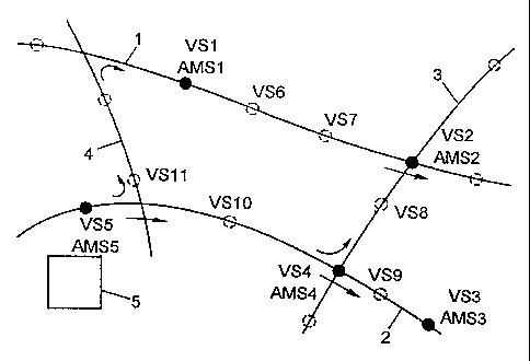
Fig. 1 shows a schematic partial view of a road system with the position of
real and
virtual measuring stations;
3a
CA 02375471 2001-11-28
P18485.S01
Fig. 2 shows a flow diagram for the parametrization of the measuring stations;
Fig. 3 shows a flow diagram for the formation of the early warning of slick
conditions of a virtual measuring station, and
Figs. 4a and 4b show schematically a pyrradiometer or a section of road used
to
determine the cloud cover.
Best Mode for Carrying Out the Invention
The procedure for forming a virtual measuring station and its operation are
explained in greater detail below. Fig. 1 shows thereby schematically several
roads 1, 2,
3, 4, of a road system, as well as an evaluating device 5 shown by a box-
shaped symbol.
This is accommodated, e.g., in a yard of the highway maintenance service and
is formed,
e.g., by a computer and interface circuits to connect the computer to the
individual
measuring stations. The computer is designed to send an early warning signal
of slick
conditions, and together with the measuring stations and the means of
connection, forms
the system for early warning of slick conditions (GFS). Several conventional
automatic
measuring stations (AMS) as AMS1 to AMS5 are shown symbolically in the figure
as
dots in the road system. Such automatic measuring stations are known in
principle and
are not shown here in detail. They include, e.g., probes for air temperature,
ground
temperature, moisture on the roadway, precipitation, relative humidity or dew
point,
freezing temperature, air speed, air pressure, and amount of traffic. The
individual probes
are arranged thereby, e.g., on masts or in the surface of the roadway and are
not described
further here, since they are known. The probe data are sent to the evaluating
device via
electric wires or radio. This device can produce an early warning signal of
slick
conditions from these data for the comesponding measuring site, which is used
as a signal
for an entire section of road. According to the invention at least one virtual
or simulated
measuring station (VS) is now provided, where the virtual measuring stations
VS1 to
VS 11 in Fig. 1 are drawn in as an example. As a rule, these virtual measuring
stations
-4-
CA 02375471 2001-11-28
P18485.S01
have no probes, which does not, however, preclude the possibility of a probe
being
present for one of the measured values; the probe equipment of an automatic
measuring
station AMS is not present, however. Since no probes are provided in the
virtual
measuring stations, they also do not have any physical connection between the
site of the
virtual station and the evaluating device 5, but are recorded in this (or in
another circuit
or device) as virtual stations. Virtual stations can also be provided at the
same sites at
which automatic measuring stations are present, as is explained in more detail
below; in
Fig. 1 this is shown for AMSINSI, AMS4/VS4, and AMS5NS5 as an example. Since
the virtual stations can be operated as a rule without expenditure for
apparatus on the
street and without a connection to the evaluating device, they are cost-
effective and can
therefore be provided in the road system in large numbers, so that a broad-
coverage
monitoring of the road system can be effected. The arrangement of the road
system in
sectors having a virtual station or their placement can be determined
according to the
results of experiments to locate places in danger of slick conditions or,
e.g., by means of
thermography.
The chief component of each virtual station is a program that accesses the
measurement data of adjacent automatic measuring stations and contains or
accesses
parameters specific to the site of the respective virtual measuring station. A
number of
automatic measuring stations AMS are therefore needed as a rule in order to be
able to
set up and operate a system for early warning of slick conditions with virtual
measuring
stations.
To set up the virtual stations, first the automatic measuring stations are
selected
that are suited to the collection of all the necessary information (measured
data and
parameters) for the virtual stations. The different types of construction in
the road system
are thereby taken into consideration (e.g., road surfaces with various
material properties,
where each type of construction is to be represented by an automatic measuring
station,
so that after they have been determined, the parameters of this type of
construction can
be used for the virtual stations at sites with the same road surface
construction.
-5-
CA 02375471 2001-11-28
P18485.S01
Furthermore, the section of road over which the melting agents are scattered
must be
taken into consideration. At least one automatic measuring station should be
present per
scattering section. In Fig. 1, the scattering sections are shown as arrows
starting from the
highway maintenance yard at AMS5.
The preferred weather data gathered for early warning of slick conditions are
the
type and amount of precipitation, air temperature, cloud cover, dew point, and
wind
strength. These data are first gathered at certain points by means of the
meteorological
GFS measuring network, i.e. a corresponding set of data is available in the
GFS network
for each automatic measuring station. Each virtual station also needs its set
of
meteorological data. This can be taken simply from an adjacent automatic
measuring
station similarly situated as far as the meteorological data are concerned,
without change.
Thus, e.g., the set of meteorological data of the automatic measuring station
AMS 1
could likewise be used for the virtual station VS6. This is done, e.g., such
that the
evaluating device 5 contains the information that the meteorological data sent
by AMS 1
are also valid for VS 1. In order to obtain a more accurate set of weather
data for each VS
station, these data can be determined as a function of the weather data of
several
automatic measuring stations (or even virtual stations), e.g.,: value (station
VS6) =
function (value (station AMS l, station AMS2 ...)). For example, the value of
the air
temperature of VS6 is determined as a function of the value of the air
temperature of
AMS 1 and AMS2. The same procedure is followed for the precipitation, dew
point,
cloud cover, and wind speed values. Linear or polynomial regressions are
suitable as
functions. This adoption of weather data for a different site must of course
be
satisfactory, but need not be perfect.
The formation of each virtual station furthermore includes a parametrization
in
which parameters applying to the station, e.g., road surface properties,
course of the
horizon, are assigned to the station. Certain parameters can be taken thereby
from
measuring stations that have the same construction. For example, the
properties of the
road surface at a certain virtual station can be taken from a measuring
station AMS that
-6-
CA 02375471 2001-11-28
P18485.S01
has the same road surface. Not all parameters can be determined in this way:
the
horizon, the visible portion of the sky, and the type of road surface, cannot,
for example.
These data must be ascertained individually at each virtual station. The
horizon, for
example, is determined by photography or manual measurement. How successfully
the
virtual station detects the actual conditions depends on the accuracy of the
parametrization. In difficult cases, a mobile measuring station can be made
available
temporarily, e.g., for two weeks, at the site of the virtual station at any
time, in order to
optimize the parametrization.
The following table shows the parameters of a virtual station.
01 Text Name of the virtual station (VS)
02 # Identifier of the VS
03 # Pertinent climatic zone
04 # AMS source for climatic data
05 # AMS source for type of road surface
06 # AMS source for freezing temperature or salt content
(last MAS before VS on the scattering route)
07 deg or rad Degree of longitude
08 deg or rad Degree of latitude
09 m Height above sea level
0, 1, 2 Roadway edge type (0: earth, 1: low bridge, 2: high bridge)
11 deg or rad Average horizontal angle in the E-SE sector
12 deg or rad Average horizontal angle in the S-SE sector
13 deg or rad Average horizontal angle in the S-SW sector
14 deg or rad Average horizontal angle in the W-SW sector
0.5-1.3 Local wind factor compared with open location
16 # Identifier of the air pressure reference station in the GFS system
17 0-100% Infrared emissivity of the roadway
18 0-100% Albedo of the roadway
-7-
CA 02375471 2001-11-28
P18485.S01
19 m Width of the roadway
20 0-100% Visible portion of the celestial hemisphere in %
21 kg/m3 Material density of the road surface (layer 0)
22 kg/m3 Material density of layer 1
23 kg/m3 Material density of layer 2
24 kg/m3 Material density of layer 3
25 J/kg/K Specific heat capacity of the road surface (layer 0)
26 J/kg/K Specific heat capacity of layer 1
27 J/kg/K Specific heat capacity of layer 2
28 J/kg/K Specific heat capacity of layer 3
29 W/m/K Thermal conductivity of the road surface (layer 0)
30 W/m/K Thermal conductivity of layer 1
31 W/m/K Thermal conductivity of layer 2
32 W/m/K Thermal conductivity of layer 3
33 m Depth of the upper boundary of layer 1
34 m Depth of the upper boundary of layer 2
35 m Depth of the upper boundary of layer 3
36 m Total depth of the roadway for the calculation
37 # Type of road surface
As stated, parameters can be used simply on the basis of the position of the
virtual
station, e.g., roadway edge type (parameter 10) and material density of the
road surface
(parameters 21-24) or can be ascertained, e.g., parameters 11-14. Other
parameters, e.g.,
the reflectance value of the road surface (parameters 17, 18) or the heat
capacity of the
road surface (parameters 25-28) are preferably ascertained and optimized by
also forniing
virtual stations in places at which automatic measuring stations are present
and deriving
the parameters to be determined from measured values of the automatic
measuring
station, where the parameters are first assumed roughly (,,best guess") and
then with these
parameters and the meteorological data taken from the automatic measuring
station, the
quantities required for warning of slick conditions are calculated. By
comparing these
-8-
CA 02375471 2001-11-28
P18485.S01
with the quantities measured by the probes of the automatic measuring station,
the
parameters can then be improved and the improved parameters can be used as the
basis
for a repeated calculation. Fig. 2 shows the corresponding course, in which
the values
of the quantities TB (temperature of the road surface) and F (road surface
moisture) are
calculated for the virtual station and are compared with the values of the
quantities TB
and F of the automatic measuring station, which has a road surface temperature
probe and
a road surface moisture probe, which enables the entire parametrization of the
measuring
point to be optimized. Two further examples: the optimum reflectance value of
the road
surface is determined on good-weather days based on the range of road surface
temperatures. The heat capacity of the road surface is found by analyzing a
phase shift
of the road surface temperature, etc. If measured values are available, these
are used, of
course. The goal is the maximum agreement of the results of the virtual
station with the
measured data of the same station.
Both the parameters and the meteorological data are now available for the
virtual
stations.
To produce an early warning signal of slick conditions, it is also necessary
to know
the freezing temperature of the liquid present on the road which, in the
conditions leading
to an early warning of slick conditions, is an aqueous melting agent solution,
as a rule.
Special freezing point probes that cool a sample of the liquid and determine
its freezing
temperature, are provided in the roadway for this purpose in the automatic
measuring
stations; this is known and is not explained here in greater detail.
As a rule, no probe is available at the site of the virtual station to
determine the
freezing temperature, however, so that the freezing temperature is determined
in a
different way in the virtual stations, in which the following two
determination methods
can be used individually (or else in combination): the one method is based on
taking the
measured freezing temperature from a measuring station with a probe that lies
on the
same scattering section as the virtual station concerned. Thus, e.g., for
virtual station
-9-
CA 02375471 2001-11-28
P18485.S01
VS6 the measured freezing temperature can be taken from the automatic
measuring
station AMS 1, after the melting agent scattering truck has passed the AMS 1
station. The
freezing temperature of AMS2 could also be used, but then it would be
necessary to wait
until the scattering truck had passed this point.
In the second method, the starting point is the scattering truck, which
records the
scattering site and amount of melting agent scattered, the former, e.g., by
means of a GPS
device. Such scattering trucks are known (e.g., Boschung BoSat System). On the
one
hand, at each use of melting agent the current amount of melting agent
scattered is
recorded by means of the Boschung BoSat System (or another mobile measuring
apparatus) and is fed to the data bank or evaluating device 5. It is recorded,
e.g., that 10
g/m2 of NaC1 were scattered from VS6 to VS7. On the other hand, the virtual
station
constantly calculates the hydric balance (see next section) and thus
determines the current
amount of water per square meter of roadway. Therefore, each use of melting
agent gives
a fixed point for the salt concentration. Until the next application, the
dilution of the salt
solution caused by additional precipitation and washing-away or evaporation is
calculated. The prerequisite is a quantified datum of the amount of
precipitation at the
measuring stations, for which probes are present in the AMS whose measured
values can
be used for virtual stations.
The calculation of the amount of water on the roadway and the freezing
temperature is based on the following equation (hydric balance on the surface
of the
roadway):
dm/dt = p(t) + l(m,...) + a(m) + d(m,...) [kg/s/mZ]
where:
m is the quantity of water on the roadway (kg/m2),
p(t) is the rate of precipitation, excluding l(m,...),
l(m, TL, TB,RF) is the rate of precipitation by condensation and evaporation
alone,
-10-
CA 02375471 2007-07-11
a(m) is the absorption of the water by the roadway, and
d(m, traffic) is the runoff rate of the water.
The quotient m1(m + p(t) + 1(m,...)) determines the present dilution of the
scattered
salt on the roadway, and d(m.... )/m expresses the loss of salt from the
roadway. The
freezing temperature is associated with the concentration of the aqueous
solution on the
roadway (phase diagram of the scattered salt or Raoult's Law at low
concentrations).
All the necessary data are now available for each virtual station. The thermal
calculation can begin. Instead of describing the method here explicitly,
reference is made
here to a publication that describes such a method. The described method or
any other
could be used, as long as it meets the same claims for accuracy. The
calculation process
must therefore take all essential physical processes into consideration.
Whether this is
a physical, statistical, or other method is not important. The goal of the
calculation called
the õvirtual station" is an early waming of slick conditions. This includes
data on the
temperature of the road surface and the moisture on the road surface, from
which the
condition of the road and the icing alarms can logically be derived. The
calculation
should be carried out at intervals of 6 to 15 minutes. Fig. 3 shows
schematically the
calculation procedure that leads to a waming of slick conditions or not,
depending on the
result.
For the thermal calculation, reference is made thereby to the publication by
H.
Nefzger, A. Karpot., Einfluss von Strahlung und Mikroklima auf
Strassenwetterprognosen [Influence of Radiation and Microclimate on Road
Weather
Forecasts], Bundesministerium fur wirtschaftliche Strassenforschung [Federal
Ministry
for Commercial Road Research], No. 466, and in particular to Part 3
(Energiebilanzmodell zur Prognose der Fahrbahnoberfldchentemperatur [Energy
Balance Model for Forecasting the Surface Temperature of the Roadway] with
equations
(11) to (19), which part is an example for a possible thermal calculation.
-11-
CA 02375471 2001-11-28
P18485.S01
The data monitoring of the virtual stations takes place as follows. By means
of the
Boschung BoSat System (or another mobile measuring apparatus), various
conditions of
the roadway are detected by probes mounted on the vehicles of the highway
maintenance
crews and/or police: e.g., temperature of the air and road surface,
atmospheric humidity,
and freezing temperature. These data can be measured on an irregular basis
when passing
the sites of the virtual stations. This gives a measuring point for each one
that allows
cross-comparison with the current calculation data of the virtual station. The
concept of
aõvirtual station" yields the following advantages compared with the
thermography
method. Firstly, the process dynamics are maintained. The data bank forms the
memory
of the system, and the calculating process translates it into action. Each
weather situation
is automatically included in the calculation. Secondly, the process can be
used at any
desired sites. The prerequisite is communication with any desired
meteorological
measuring network, such as, e.g., the GFS measuring network, which has been
described
in the previous description as a provider of meteorological data. The
meteorological data
can also be delivered by a different measuring network, however, e.g., the
ANETZ of the
SMA (Schweizerische Meteorologische Anstalt [Swiss Meteorological Institute]).
Thirdly, no relevant streams of heat and moisture are ignored. In particular,
the hydric
balance can be taken into consideration to the full extent in the calculation
model.
Fourthly, a virtual station is, of course, more cost-effective than a
measuring station,
since it consists chiefly or exclusively of software.
The accuracy of a virtual station may at first appear lower than that of
thermography, since the latter measures the three temperature profiles with
high
resolution and accuracy. It is worth considering, however, that these profiles
are merely
a snapshot that reflect a quite specific weather situation, time of day,
temperature, and
previous road and weather conditions. Therefore, they are not well-suited for
an
interpolation under all conditions. A substantial loss in accuracy must
therefore be taken
into account. The virtual station can compensate for this, owing to its
flexible
calculation.
-12-
CA 02375471 2001-11-28
P18485.S01
A further aspect of the invention concerns the detection of cloud cover, which
is
included in the thermal balance calculation according to equation (11).
Detection of the
cloud cover requires either human observation or the use of a measuring
instrument for
determining the infrared radiation balance (pyrradiometer). These instruments
are
susceptible to soiling, however, and are expensive to maintain. Their use in
roadway
measuring networks is therefore not preferred. Instead, the road itself can be
used as a
substitute pyrradiometer: the road surface temperatures are calculated with
various
assumed degrees of cloud cover in an approximation method, until they agree
with the
measured road surface temperatures. This degree of cloud cover is then
interpreted as the
current measured value and is stored in the data bank. Figs. 4a and 4b show
schematically, on the one hand, a known pyrradiometer, by means of which the
global
radiation QG (0.3-3.0 m) and the infrared radiation QTR (3.0-50 m) are
measured;
in the pyrradiometer the latent heat flow (condensation, evaporation, etc.)
QL, the sensory
heat flow (convection, wind) QS, and the heat conduction within the road
(diffusion) are
assumed to be zero. When the road is used as a pyrradiometer, QL, QS, and QD
are
detected by computer and QTR + QG are optimized by comparing the calculated
road
surface temperature TB (measured) with the measured road surface temperature
(computer); the prevailing cloud cover is deduced from QIR and QG.
-13-
_
_. ._.._.._,......,..,,..,_...~.____.......