Note: Descriptions are shown in the official language in which they were submitted.
CA 02384810 2002-03-12
WO 01/23829 PCT/US00/25804
Determining Optimal Well Locations From a 3D Reservoir
Model
BACKGROUND OF THE INVENTION
Field of the Invention
The present invention relates generally to methods for minimizing the costs of
extracting petroleum from underground reservoirs. More specifically, the
present
invention relates to determining optimal well placement from a three-
dimensional model
of an underground reservoir.
Description of the Related Art
A critical function of reservoir management teams is the generation of a
reservoir
development plan with a selection of a set of well drilling sites and
completion locations
that maximizes productivity. Generation of the plan generally begins with a
set of
reservoir property maps and a set of infrastructure constraints. The team
typically
includes geologists, geophysicists, and engineers who choose well locations
using
reservoir models. The wells are located to optimize some desired property of
the
reservoir that is related to hydrocarbon productivity. In the early
development of a field,
these models might consist of porosity or lithology maps based primarily on
seismic
interpretations tied to a few appraisal wells. Once given the model, the team
is often
asked to quickly propose a set of locations that maximize production.
Complicating this
endeavor is the requirement that the selected sites obey a set of constraints,
e.g.
minimum interwell spacing, maximum well length, minimum distance from fluid
contacts or reservoir boundaries, and well configuration constraints. The
combined
1
CA 02384810 2007-09-21
problem is highly combinatorial, and therefore time consuming to solve. This
is
especially true for reservoirs that are heterogeneous with disconnected pay
zones.
Practical solutions to this problem typically involve evaluating a small
subset of the
possible well site combinations as case studies, and then selecting those with
the highest
value of the desired productivity metric, e.g. net pay or permeability-
thickness
(represented as "quality").
As a reservoir is developed with production wells, a more comprehensive
reservoir
model is built with detailed maps of stratigraphy and pay zones. Pressure
distribution
maps or maps of fluid saturation from history matching may also become
available.
Then, proposing step-out or infill wells requires the additional consideration
of
constraints imposed by performance of the existing wells. Thus, the choice of
selecting
well locations throughout the development of a reservoir can become
increasingly
complicated. Again, this is especially true for reservoirs that are
heterogeneous with
disconnected pay zones. Finding solutions to the progressively-more complex
well
placement problem can be a tedious, iterative task.
There have been several reported studies that have attempted to use ad hoc
rules and
mathematical models to determine new well locations and/or welt configurations
in
producing fields.
1. Seifert, D., Lewis, J.J.M., Hem, C.Y., and Steel, N.C.T., "Well Placement
Optimisation and Risking using 3-D Stochastic Reservoir Modelling Techniques",
SPE
35520, presented at the NPF/SPE European Reservoir Modelling Conference,
Stavanger, April 1996.
2. P. A. Gutteridge and D. E. Gawith, "Connected Volume Calibration for Well
Path
Ranking", SPE 35503, European 3D Reservoir Modelling Conference, Stavanger,
April
16-17, 1996.
2
CA 02384810 2002-03-12
WO 01/23829 PCT/US00/25804
3. Rosenwald, G. W., and Green, D. W., "A Method for Determining the Optimum
Location of Wells in a Reservoir UsingMixed-Integer Programming", SPE J.,
(1973).
4. Lars Kjellesvik and Geir Johansen, "Uncertainty Analysis of Well Production
Potential, Based on Streamline Simulation of Multiple Reservoir Realisations",
EAGE/SPE Petroleum Geostatistics Symposium, Toulouse, April 1999.
5. Beckner, B. L. and Song X., "Field Development Planning Using Simulated
Annealing - Optimal Economic Well Scheduling and Placement", SPE 30650, Annual
SPE Technical Conference and Exhibition, Dallas, October 22-25, 1995.
6. Vasantharajan S. and Cullick, A. S., "Well Site Selection Using Integer
Programming
Optimization", IAMG Annual Meeting, Barcelona, September 1997.
7. Ierapetritou, M. G., Floudas, C. A., Vasantharajan, S., and Cullick, A. S.,
"A
Decomposition Based Approach for Optimal Location of Vertical Wells", AICHE
Journal 45, April, 1999, p. 844-859.
8. K. B. Hird and O. Dubrule, "Quantification of reservoir Connectivity for
Reservoir
Description Applications", SPE 30571, 1995 SPE Annual Technical Conference and
Exhibition, Formation Evaluation and Reservoir Geology, Dallas, TX.
9. C. V. Deutsch, "Fortran Programs for Calculating Connectivity of three-
dimensional
numerical models and for ranking multiple realizations," Computers &
Geosciences,
24(1), p. 69-76.
10. Shuck, D.L., and Chien, C.C., "Method for optimal placement and
orientation of
wells for solution mining", U.S. Patent No. 4,249,776, Feb. 10, 1981.
11. Lo, T. S., and Chu, J., "Hydorcarbon reservoior connectivity tool using
cells and pay
indicators", U.S. Patent No. 5,757,663, March 26, 1998.
Seifert et al' presented a method using geostatistical reservoir models. They
performed an exhaustive "pin cushioning" search for a large number of
candidate
trajectories from specified platform locations with a preset radius,
inclination angle,
well length, and azimuth. Each well trajectory was analyzed statistically with
respect to
intersected net pay or lithology. The location of candidate wells was not a
variable;
thus, the procedure finds a statistically local maximum and is not designed to
meet
multiple-well constraints.
Gutteridge and Gawith2 used a connected volume concept to rank locations in 2D
but did not describe the algorithm. They then manually iterated the location
and design
3
CA 02384810 2002-03-12
WO 01/23829 PCTIUSOO/25804
of wells in the 3D reservoir model. This is a "greedy" approach that does not
accommodate the constraints on well locations, and the selection of well sites
is done in
2D. Both this and the previous publication are ad hoc approaches to the
problem.
Rosenwald and Green3 presented an Integer Programming (IP) formulation to
determine the optimum location of a small number of wells. He assumed that a
specified production versus time relationship is known for the reservoir and
that the
potential locations for the new wells are predetermined. The algorithm then
selected a
specified number of wells from the candidate locations, and determined the
proper
sequence of rates fi-om the wells.
Kjellesvik and Johansen4 ranked wells' drainable volumes by use of streamlines
for
pre-selected sites. The streamlines provide a flow-based indicator of the
drainage
capability, and although streamline simulation is significantly faster than a
full finite-
difference simulation, the number of required operations in an optimization
scheme, e.g.
simulated annealing or genetic algorithm, is still O(NZ), where N is the
number of active
grid cell locations in the model. The compute time is prohibitive when
compared with
using a static measure. Beckner and Song5 also used flow simulation tied with
a global
optimization method, but they were only able to perform the optimization on
very small
data volumes.
Vasanthrajan and Cullick6 presented a solution to the well site selection
problem for
two-dimensional (2D) reservoir maps as a computationally efficient linear,
integer
programming (IP) formulation, in which binary variables were used to model the
potential well locations. This formulation is unsuitable for three-dimensional
data
4
CA 02384810 2002-03-12
WO 01/23829 PCT/US00/25804
volumes. A decomposition approach was presented for larger data problems in
three-
dimensional (3D) maps by Ierapetritou et al'.
Hird and Dubrule8 used flow simulation in 2D reservoir models to assess
connectivity between two well locations. This was for relatively small models
in 2D
and only assesses connectivity between two specific points. C. V. Deutsch9
presents a
connectivity algorithm which approaches the problem with nested searches of
growing
"shells". This algorithm is infeasibly slow.
Shuck and Chien10 presented an ad hoc well-array placement method that selects
the
cell pattern of the well-array so that the cell area is customized and the
major axis of the
cells are parallel to the major axis of transmissivity of the well field. This
method does
not determine optimal locations for individual wells.
Lo and Chu11 presented a method for estimating total producible volume of a
well
from a selected well perforation location. No optimization of the total
producible
volume is sought in this reference.
The above publications fail to provide a feasible method for selecting optimal
or
near-optimal well completion locations in a 3D reservoir model for a variety
of reasons,
not the least of which is the size of the problem space. Typical 3D seismic
models
include 107-10g voxels (volumetric pixels, a.k.a. cells), and the methods
described in the
above publications cannot efficiently find a solution. Accordingly, a need
exists for a
systematic method of identifying optimal or near-optimal well locations in a
three-
dimensional reservoir model. Preferably, the method would be computationally
efficient,
and would account for the sophisticated drilling technology available today
that allows
5
CA 02384810 2002-03-12
WO 01/23829 PCT/US00/25804
horizontal and/or highly deviated completions of variable lengths which can
connect
multiple high-pay locations.
SUMMARY OF THE INVENTION
There is disclosed herein a systematic, computationally-efficient, two-stage
method
for determining well locations in a 3D reservoir model while satisfying
various
constraints including: minimum interwell spacing, maximum well length, angular
limits
for deviated completions, and minimum distance from reservoir and fluid
boundaries.
In the first stage, the wells are placed assuming that the wells can only be
vertical. In
the second stage, these vertical wells are examined for optimized horizontal
and
deviated completions. This solution is expedient, yet systematic, and it
provides a good
first-pass set of well locations and configurations.
The first stage solution formulates the well placement problem as a binary
integer
programming (BIP) problem which uses a "set-packing" approach that exploits
the
problem structure, strengthens the optimization formulation, and reduces the
problem
size. Commercial software packages are readily available for solving BIP
problems.
The second stage sequentially considers the selected vertical completions to
determine
well trajectories that connect maximum reservoir pay values while honoring
configuration constraints including: completion spacing constraints, angular
deviation
constraints, and maximum length constraints. The parameter to be optimized in
both
stages is a tortuosity-adjusted reservoir "quality". The quality is preferably
a static
measure based on a proxy value such as porosity, net pay, permeabilty,
permeability-
thickness, or pore volume. These property volumes are generated by standard
6
CA 02384810 2007-09-21
techniques of seismic data analysis and interpretation, geology and
petrophysical
interpretation and mapping, and well testing from existing wells. An algorithm
is
disclosed for calculating the tortuosity-adjusted quality values.
In one particular embodiment there is provided a method to determine locations
for a
plurality of wells, wherein the method comprises: receiving a well
productivity proxy
value for each voxel of a seismic derived property data volume; processing the
well
productivity proxy values to identify geobodies; computing a reservoir quality
value for
each voxel in the geobodies; and using integer programming to locate
completion point
voxels that maximize a sum of associated reservoir quality values subject to
specified
constraints.
BRIEF DESCRIPTION OF THE DRAWINGS
A better understanding of the present invention can be obtained when the
following
detailed description of the preferred embodiment is considered in conjunction
with the
following drawings, in which:
Figs. 1 and 2 are a flowchart of a geobody identification method;
Fig. 3 is an exemplary 3D porosity data volume;
Fig. 4 is data volume showing the identified geobodies;
Fig. 5 is a flowchart of a reservoir quality calculation method;
Fig. 6 is a schematic illustration of a deviated well; and
Fig. 7 is a flowchart of the horizontalldeviated well path selection method.
7
CA 02384810 2007-09-21
While the invention is susceptible to various modifications and altetnative
forms, specific embodiments thereof are shown by way of example in the
drawings and will herein be described in detail. It should be understood,
however, that the drawings and detailed desctiption thereto are not intended
to
limit the invention to the particular form disclosed, but on the contrary, the
intention is to cover all modifications, equivalents and alternatives falling
within
the spirit and scope of the present invention as defined by the appended
claims.
7a
CA 02384810 2002-03-12
WO 01/23829 PCTIUSOO/25804
DETAILED DESCRIPTION OF THE PREFERRED EMBODIMENT
For explanatory purposes, the following discussion focuses on the well site
selection
issues faced by a reservoir management team during the initial stages of a
project
development, where the wells are sited to maximize productivity while honoring
the
constraints. It is recognized that the disclosed method and techniques are
applicable to a
much wider variety of problems, and the following discussion is not intended
to limit
the scope of the claimed invention.
Static Metric For Reservoir Productivity
The measure of reservoir productivity during the initial project stage is
normally
chosen to be a static metric of the reservoir productivity, e.g. net pay
(defined as
porosity x thickness x area x net-to-gross x hydrocarbon saturation),
permeability-
thickness, or a combination. In other words, underground fluid movements are
most
often not considered in determining well location at this field development
stage. The
focus is on modeling the spatial and configurational constraints such as
minimum
interwell spacing, maximum well length, angular limits for deviated
completions, total
capital available or maximum number of wells and minimum distance from
reservoir
and fluid boundaries, distance from offshore platforms or drilling pads that
have to be
factored into the choice of these locations. Subsequent detailed flow
simulation may
then be conducted to determine an appropriate production policy from these
well
candidates to meet desired production targets.
For the preferred embodiment, the static measure is reservoir "quality", or
more
preferably, tortuosity-adjusted reservoir quality. The reservoir quality
calculation is
8
CA 02384810 2002-03-12
WO 01/23829 PCT/USOO/25804
based on some property measurement that can serve as a proxy for the amount or
producibility of hydrocarbons available for extraction by a well. Examples of
suitable
well production proxy measurements include: porosity, net pay, permeability,
permeability thickness, and pore volume. Standard techniques exist in the
fields of
seismic analysis and interpretation, geology and petrophysical interpretation
and
mapping, and well testing, to determine such values for each volumetric cell
(hereafter
termed "voxel") of a 3D reservoir model.
The reservoir quality of a given voxel is calculated by summing the connected
proxy measurement values within an estimated drainage radius of a prospective
well of
the given voxel. The proxy measurement values may optionally be multiplied by
the
associated voxel volumes prior to the summation. For example, if the proxy
value is
porosity, then the quality represents the summed connected pore volume within
the
assumed drainage radius. If the proxy value is net pay (defmed as the product
of
porosity, hydrocarbon saturation, volume, and a net-to-gross ratio), then the
quality is
equivalent to producible hydrocarbon volume in the volume connected to the
given
voxel. Quality may be a better proxy to productivity than porosity alone, as
porosity is a
strictly local measure, whereas quality assesses the connected pore volume.
The method
of Lo and Chu" may be adapted to the present application, but a more preferred
quality
calculation method is described below.
One of the issues addressed by the preferred quality calculation method is
tortuosity. In reservoirs with many boundaries, sinuous channels, or pay that
is
interspersed with shale or diagentically altered rock, the actual flow
streamlines in a
volume can be tortuous. Accounting for tortuosity associated with the proxy
measurements improves the reliability of the static measure.
9
CA 02384810 2002-03-12
WO 01/23829 PCTIUSOO/25804
The preferred embodiment of the disclosed method calculates reservoir quality
by
first "trimming" proxy measurement values below a chosen cutoff value. This
may be
accomplished by assigning proxy measurement values of zero to voxels having
values
below the cutoff, or alternatively by designating such voxels as "inactive". A
connectivity algorithm is then executed to identify collections of connected,
active
(nonzero) voxels. These collections are hereafter termed geobodies.
The proxy measurement values are generated from "data volumes" of measured
properties (e.g. amplitude, impedance, porosity, and porosity-thickness) that
can contain
10's to 100's of millions of data values. Evaluation of reservoir connectivity
has
traditionally been tedious. In the past, geoscientists have had available a
tool to identify
a single connected body, given a seed point such as a location on a wellbore.
Each body
had to be identified and rendered visually one at a time. For large volumes
with many
bodies, e.g. -105, this process has been known to take many hours, and even
days or
weeks. Previous automatic algorithms for geobody detection have been tried.
The
problem has been their slow computation for data volumes of large size. For
example,
Gutteridge and Gawith2 did their geobody detection for 3D models in 2D
"shells" to
make a practical computation. Deutsch's9 algorithms produce the following
computation times (the computation time increases by about three orders of
magnitude
for each order of magnitude increase in the number of grid cells).
Data volume size in Compute time in
grid cells seconds (Ref. 9)
10 <1
10 5 10
10 10
10 _106 (extrapolated)
CA 02384810 2002-03-12
WO 01/23829 PCTIUSOO/25804
In comparison, the connectivity algorithm disclosed herein has an
approximately
linear increase with volume size. The compute time depends on the number of
active
grid cells and the number of separate geobodies. A few examples are given in
the
following table.
Data volume size in Approximate compute
grid cells time in seconds
4 x 10⁶ 120
3x10 600
1.2 x 10 1200
The algorithm quickly determines the internal connectivity within a large 3D
data
volume. The connected bodies, referred to as geobodies are indexed by size,
which
allows them to be selected individually or in groups to be rendered visually.
The preferred connectivity algorithm is specified by Figs. 1 and 2. Starting
with
block 102, the algorithm instructs a computer to load the 3D array of measured
properties. In block 104, the 3D array is processed to determine which cells
are "valid".
Cells are valid if the associated properties are within a specified
measurement range
(e.g. the measured property value is greater than a specified cutoff value).
If no cells are
valid, the algorithm terminates in block 106. Otherwise, in block 108 a
geobody number
array having the same dimensions as the 3D array is initialized to "1" in
valid cells, and
"0" in all other cells. In block 110, the number of geobodies (NGEO) is
initialized to 1,
and in block 112, a location index (LOC) is set to point to a first cell. In
block 114, the
location index will be incremented through all cells in the 3D array. In block
116, a test
is made to see if all cells have been processed. If so, then in block 118 the
geobody
11
CA 02384810 2002-03-12
WO 01/23829 PCT/USOO/25804
number array is processed to determine the size of each geobody, and in block
120, the
geobodies are reordered so as to be indexed by size (the first geobody will be
the
largest). The algorithm then terminates after block 120.
Otherwise, in block 122 a test is made to see if the cell of the geobody
number array
indicated by the location index is valid and not yet assigned a geobody
number. If not,
the location index is incremented in block 114, and control returns to block
116.
Otherwise, the number of geobodies is incremented in block 124, and the cell
is
assigned the current geobody number in block 126. A visited valid cell (VVC)
list is
initialized to 0 in block 128, and two counters for that list are initialized
to 1. The
geobody identification loop 132 is then performed, and control subsequently
loops back
to block 114.
Fig. 2 shows the geobody identification loop 132. In block 202, the first
element of
the VVC list is set equal to the location index LOC. In block 204, a test is
made to see
all the elements of the WC list have been processed. If so, control returns to
block 114.
Otherwise, a current location index (CLOC) is set to the location of the
current element
of the VVC list in block 206. A neighboring cell index (NCELL) is set equal to
a first
neighboring cell in block 208. Subsequently, NCELL will be indexed through all
neighboring locations to CLOC in block 216. The definition of "neighboring
cells" may
be varied, but preferably the neighboring cells are the six cells that share a
face with the
CLOC cell. In block 210, a test is made to determine if all the neighboring
cells have
been considered. If so, counter 2 is incremented in block 212, and control
returns to
block 204. Otherwise, in block 214, a test is made to determine if the
neighboring cell is
valid and not yet assigned a geobody number. If not, then NCELL is incremented
in
block 216. If so, the neighboring cell is assigned the current geobody number
in block
12
CA 02384810 2002-03-12
WO 01/23829 PCT/US00/25804
218, and blocks 220 and 222 add the neighboring cell to the VVC list. The
NCELL
index is then incremented in block 216. Alternative neighboring cells (Block
208) may
be defined as any and all combinations of the six face-sharing cells, the
additional
twelve edge-sharing cells, and the additional nine corner-sharing cells. The
27-point
search of all neighbor cells is preferred when the reservoir pay is thin and
dip relative to
the cell orientation. The six-point search of face-sharing cells is preferred
when the
reservoir pay is thicker than the cell thickness with little dip relative to
the cell
orientation. The 18-point search of neighbors is preferred for intermediate
circumstances.
To calculate reservoir quality, geobodies are first generated using the
disclosed
connectivity algorithm. Fig. 3 shows a 3D measured property array of
approximately 30
million cells. This array is a porosity volume (i.e. the measured property is
porosity).
The array is 351x351x241 cells, and each cell is approximately 29 meters x 29
meters x
3 meters. The original seismic amplitude data were converted to a resistivity
volume
and a fraction of shale volume V.,hale using neural networks calibrated with
well log
data. The porosity volume is an estimate based on a combination of the
resistivity and
Vshale using proscribed cutoffs. The porosity cutoff was 12%. Visualization of
the
porosity volume yields little information about the connectivity of the
porosity. Fig. 4
shows the geobodies generated by the connectivity algorithm.
A reservoir quality value is calculated for each voxel of the model by summing
the
values of the proxy measurements within a drainage volume around each voxel
that are
in the same geobody as the voxel, multiplied by the voxel volumes. To adjust
for the
tortuosity of the actual flow streamlines, a tortuosity algorithm is used. The
tortuosity
algorithm utilizes a random walker to determine the extent to which noflow
boundaries
13
CA 02384810 2002-03-12
WO 01/23829 PCT/USOO/25804
are contained within the drainage volume. Random walkers essentially detect
the
pathway lengths from each cell location to all boundaries within the drainage
volume,
and reduce the contribution of properties that are located farther away from
the voxel in
question.
Fig. 5 shows one implementation of a random walker method for calculating
tortuosity-adjusted reservoir quality values. Starting with blocks 202-206,
software
instructs the computer to load the 3D measured property array, load the 3D
geobody
array from the previous algorithm, and initialize a 3D quality array to zero.
These arrays
share common dimensions. A location index LOC is initialized to the first cell
in these
arrays in block 208, and is sequentially incremented through all cells in
block 220. In
block 210, a test is made to see if the index has been incremented through all
cells. If
so, the software terminates. Otherwise, in block 212, the range of cells that
could
potentially be drained from the current location is determined. In a preferred
embodiment, this volume is a rectangular volume of cells determined from
multiplying
the drainage radius by an aspect ratio in each direction. The maximum number
of edges
is calculated in block 214. This is preferably equal to the number of cell
faces on the
surface area of the drainage volume. However it is chosen, this number will be
the
maximum number of random-walk paths that are generated from the current
location. A
path counter is initialized to 1 in block 216, and in block 218, a test is
made to see if the
counter is less than or equal to the maximum number of edges. If not, then the
software
moves to the next cell location in block 220. Otherwise, a new "walker" is
started at the
current location in block 222. In block 224, the walker is moved one cell in a
random
direction. In blocks 226-230, a series of tests are made to see if the walker
has moved
outside the 3D array, outside the drainage volume, or outside the current
geobody. If
14
CA 02384810 2002-03-12
WO 01/23829 PCT/US00/25804
any of these are true, the software increments the path counter in block 232.
Before
starting a new walker, the software tests to see if the quality measurement
has
"saturated" in block 234. In one embodiment, the test involves testing to see
if the
quality value for the current location has changed by more than a
predetermined
tolerance over a predetermined number of paths. For example, if the quality
has not
changed by more than 1% in the last 100 paths, the software assumes that the
quality
measurement has saturated, and the software moves to the next location in
block 220. If
saturation has not occurred, then the software returns to block 218.
If the tests in blocks 226-230 have shown that the walker is still in the
drainable
volume, then in block 236, a test is made to see if the walker's current
position has
already been visited. If so, then the software returns to block 224 to take
the next step
for the walker. Otherwise, the measured property value of the current walker
position is
added to the quality for the current cell location before the next walker step
is taken.
This method of determining reservoir quality value for a cell effectively
decreases the
contribution of measured property values for cells that are less likely to be
reached by
the random walker. These cells are those cells that are further from the
current cell
location, and those cells that are connected to the current cell via a small
"window", i.e.
a tortuous pathway. An alternative embodiment would adjust the quality by the
flow
resistance of the path, as provided by permeability values in the cells. The
productivity
proxy of tortuosity-adjusted quality should differentiate well sites nearer a
center of
highly connected volume from those nearer its boundary.
CA 02384810 2002-03-12
WO 01/23829 PCT/USOO/25804
2D Well Placement
Having now determined a static measure that is related to reservoir fluid
productivity, the next step in reservoir management is the placement and
configuration
of wells. The objective function for well selection should maximize the set of
all wells'
production, while meeting specified constraints. In practice, well locations
are often
selected by attempting to maximize the contact with the static measure.
The mathematical model to ensure interwell spacing for such involved
completions
is extremely difficult to formulate, and would lead to an explosion in problem
size that
cannot be solved with the capability of today's computers and numerical
algorithms.
Therefore, the preferred method is a two-stage decomposition strategy that
first solves
the problem of determining completions for strictly vertical wells within the
3D-
reservoir data volume. In the second stage, the vertical wells selected become
candidate
locations to be considered for high-grading into horizontal or highly deviated
wells.
This method systematically determines highly deviated trajectories that can
reach
disconnected high-pay areas in a given 3D volume while honoring constraints of
maximum well length and deviation angles. The second stage model uses graph
theory
principles to provide a novel, compact framework for determining the ideal
trajectory
length and azimuth of a horizontal or deviated well to maximize productivity
Because of the two-staged strategy, and the sequential nature of the high
grading
procedure, the final set of well configurations and locations selected cannot
be proven
to be strictly optimal. Still, the proposed method provides an automated
procedure to
quickly determine a good set of vertical and highly deviated well completions
that
16
CA 02384810 2002-03-12
WO 01/23829 PCT/US00/25804
intersect high-quality reservoir property locations, while obeying well
spacing and other
spatial constraints.
In the preferred method, the location of wells is formulated as a binary
integer
program (BIP), for which the location of a take-point at a particular location
in the
reservoir is a 0/1 for an on/off decision. BIPs can only be solved by
enumeration. Thus,
severe restrictions are presented by both the numerical algorithms available
and by the
computing power available for solving large-scale, complex BIPs. Considerable
attention has to be given to the model formulation to identify specific
structures and/or
features that can be exploited by the numerical algorithms to solve practical
problems.
The problem can be stated in the following manner:
Let a set I, {1, 2,.. .,N} denote all potential well locations, and let
indices i, j E I.
Let a binary variable Y,. E{0,1} denote the existence/non-existence of a well
site, and let Q; be its associated reservoir "quality" value. Associated with
each
well site is a known cost for drilling and completion, C;. The general problem
of
determining well drilling sites can be expressed qualitatively as follows:
N N
Maximize Q; Y, -~ C, Y,
r=i s=i
subject to constraints that include: well locations, well spacing, well
configuration, and capital available.
The following sections describe mathematical formulations that quantitatively
model the set of constraints listed above. While these discussions focus on
the
development of efficient formulations to describe the "well configuration"-
type
constraints, it can be seen that the same techniques can be applied to
characterize the
17
CA 02384810 2002-03-12
WO 01/23829 PCTIUSOO/25804
other types of constraints. All the optimization models developed are flexible
and
scaleable, and can easily accommodate these and other constraints.
In the first stage, the 3D-reservoir quality volume is used to generate a 2D
quality
map. The 2D quality map is determined by setting the quality value for a cell
to the
maximum quality in the corresponding column of cells in the 3D volume. Each
cell in
the 2D array can be considered as a potential site where a well can be
drilled. The 2D
maps are generally on the order of a few tens of thousands of cells each. The
task is to
select a subset of these potential locations that will maximize the cumulative
value of
the property, while ensuring that the planar distance between the selected
sites is over
a certain specified minimum to avert well interference.
The following terms are now defmed:
Let (x;, y;) denote the known coordinates of these locations on a rectangular
grid
Let D;~ be the Euclidean distance between any two well sites (i, j)
D,~ = x,-xJ + ,-y,
Let D,,;,, denote the minimum desired well spacing (in grid units)
Let Nm.. . denote the maximum number of wells to be selected
The BIP formulation for well site selection in 2D reservoir maps can be
expressed:
N N
(1) Maximize Q; Y; -~ C; Y; ,
J=i 7=i
subject to the constraints:
(2) Y,. E {0,1}
(3) YI +Yj <_ 1, {j I i# j, Dtl <_ Dmin
(4) 1 Y < Nm.
,Er
18
CA 02384810 2002-03-12
WO 01/23829 PCT/US00/25804
Equation (1) represents the total benefit and cost of placing the vertical
wells. Equation
(2) states that Y is a binary variable. Equation (3) enforces the interwell
spacing
constraint, and Equation (4) limits the number of wells to a maximum. As
Equation (3)
is equivalent when i andj are interchanged, care should be taken to avoid
unnecessarily
duplicating constraint equations.
It is noted that equation 3 actually represents a large number of constraint
equations
(roughly D2n,;nN/2), which causes identifying vertical well sites in typical
2D reservoir
maps to be an intractably large problem. Equation 3 can be restated in another
way:
(5) Y, +Yj <_ 1, j I i#j, D~ '< Di~ _ Dn,in
(6) YI+FYj51,J= jlio j,D,~<_D~}
~ )
J
In addition to significantly reducing the number of constraint equations, this
formulation places many of the constraint equations in a"set-packing" form
that
commercial software solvers can exploit to reduce the problem space.
Specifically,
commercial IP solvers like CPlex ' and OSL can exploit the form of Equation 6
by
"branching" on the involved binary variables as a "special order set".
19
CA 02384810 2002-03-12
WO 01/23829 PCT/US00/25804
3D Well Placement
With 2D reservoir maps, the focus is on ensuring that the planar distance
between
selected well sites was greater than a specified minimum. In 3D reservoir
volumes the
reservoir stratigraphic properties also exhibit variations in the vertical or
z-direction. If
there is sufficient variation of the reservoir property in the z-direction,
one can decide to
complete a well in multiple zones at varying depths. Thus, with 3D volumes, it
is not
sufficient to just ensure that the well drilling sites meet the distance
constraints in the (x,
y) plane. Additionally, one must ensure that the well completions, located
along the z-
direction, must also meet these constraints. Further, for horizontal or
deviated wells, one
must ensure that these constraints are satisfied along the entire length of
the well
trajectories.
The color coded objects in Fig. 4 illustrate unconnected geobodies. The
"quality" of
a well completed in a geobody is hereby defined as the maximum "quality"
encountered
in all vertical voxels that are in the same geobody at that map location (i.e.
maximum
quality in a column of a geobody). The wells should have a minimum spacing of
D,,;,, if
they are completed within the same geobody. If there are disconnected
reservoir flow
units, i.e., different geobodies, the wells can be spaced at less than Dm;,,.
If there are
overlying flow units that could be completed by a single wellbore, there
should be a
cost for multiple completions included in the objective function.
The well-site selection process models the 3D volume as a stack of 2D layers.
The
cells in the topmost layer which are distributed in the (x, y) domain
correspond to
potential well sites, as in the 2D case. Let W represent this set of potential
well sites.
Now, from each of these sites, as the layers are traversed down in a straight
line in the z-
CA 02384810 2002-03-12
WO 01/23829 PCT/USOO/25804
direction, geobody voxels are encountered. There are as many potentially valid
completions for each (x, y) well site as there are z-locations that intersect
different
geobodies (i.e. stratigraphically separate layers). Let G represent the set of
geobody
voxels. The combination of these sets, i.e., (N;G), denotes all valid
completions.
Associated with each such valid completion is a "quality". The formulation
defines a set
of binary variables, Y(WG), to be binary variable array having 0/1 values to
indicate the
presence/absence of a completion. Q(W,G) is the array of associated "quality"
values.
Next, spacing constraints need to be enforced on different well completions
within a
geobody (intra-geobody). Note that inter-geobody completions are not
constrained. It is
observed that these constraints can be defmed by considering one geobody at a
time,
and writing the set of well spacing constraints as shown in equations (5) and
(6).
An interesting aspect of this problem is the formulation of the objective
function, as
it is desired to trade-off maximizing the overall "quality" of the selected
well locations
against the cost of drilling and completing the wells. The first term in the
objective
function serves to maximize the cumulative quality of the selected locations:
(7) Max 11 Q Y
W G
The fiscal terms are as follows: If a well is singly completed, it incurs a
specified
cost, say a. Additional completions are treated as being some fraction of this
cost, say
'ha each. To model this cost structure a fixed cost term is defined equal
to'/za, which is
incurred when a well is completed. It can be easily shown that this
formulation
represents the desired cost structure. However, to represent this
quantitatively, an
additional variable is necessary to model the selection of a well site.
(Recall that the
21
CA 02384810 2002-03-12
WO 01/23829 PCTIUSOO/25804
variable Y now denotes that the completion of a well in a geobody, and not the
selection
of well site.) The binary array X(W) is therefore defined to indicate the
presence/absence of a well in the set of planar locations W, i.e., the (x, y)
domain of the
map. Since all completions are for strictly vertical wells, only one X(x, y)
location
variable is introduced for all corresponding Y(x, y, z) variables. The
proposed cost
structure can be incorporated into the objective function as:
(8) Max Q(T'T', G)Y(N', G) - 1: X(W) - a EEY(W,G)
W G 2 W 2 W G
The two sets of binary variables Y and X are related, and the relationship can
be
stated:
(9) X(W)>_Y(W,G),b'G
The above set of equations ensure that if a well is completed in a geobody,
i.e., if
any of the binary variables, Y(WG), is equal to 1, then the associated well
drilling site,
XM, is also equal to 1. The converse of this statement, i.e. "if all
completions
associated with a well site are not selected, i.e., Y(W,G) is zero, then the
associated
binary variable X(W), is zero", is assured by the objective function given in
equation
(8), since X(W) is part of the negative cost term in an objective function
that is being
maximized. In fact, one can see that the variables, X(W), need not even be
explicitly
declared to be of type binary, but may be treated as a continuous variable
bounded
between 0 and 1. The form of the objective function, and the constraint
representation
shown above, ensure that X(W) can only take on the appropriate integral
values.
The final model to determine the optimal set of well sites and strictly
vertical
completions in a 3D- reservoir model is:
22
CA 02384810 2002-03-12
WO 01/23829 PCTIUSOO/25804
(10) Max I:Q(W,G)Y(W,G) - a I:X(W) - a I:Y(W,G)
(W,G) 2 W 2 (W,G)
subject to the following constraints:
(11) Y(W,G)+Y.j(W,G) <_ 1, jl i# j, Dmin <Dtj <Dmin i, j E(jN',G)
(12) Y +ZYj <l,~jJi#j,D;~<D~I,jE(T~',G)
J
(13) X; (W) <_ N.
(14) X(W) >_ Y(W,G),'d G
(15) Y(W,G) E {0,1}
(16) 0<_X(W)<_1
The bottleneck in the formulation shown above is still the calculation and
specification of the constraints to ensure that wells completed within the
same geobody
are separated by at least D,õ;,,. This effort is directly related to the
number of voxels, i.e.,
potential completions, in a geobody, as the constraints have to be defined for
all "pair
combinations" of such completions that are spaced less than Dri,;,,. Thus, 3-D
maps
which are highly connected, i.e., are composed of a few, densely populated
geobodies
(_106 potential completions per geobody) can be time consuming to define and
solve.
However, as inter-geobody constraints are not enforced, large reservoirs that
are
heterogeneous with disconnected pay zones can be solved efficiently.
To illustrate the advantages of the above method, its performance is
contrasted with
a "greedy" procedure. The greedy procedure sequentially selects the well
locations in
descending order of reservoir "quality", while honoring the constraints of
well spacing.
The steps in such a procedure are:
23
CA 02384810 2002-03-12
WO 01/23829 PCT/US00/25804
1. At each planar location W, determine the maximum quality in the column of
voxels as its representative "quality"
2. Eliminate from consideration locations with qualities below the minimum
cutoff value
3. Select highest quality well completion location remaining
4. Eliminate from future consideration all remaining locations in the same
geobody that are within D;r, of the well completion selected
5. If the number of locations selected is less than the maximum allowed,
return
to step 3.
6. Compute cumulative quality and cost of locations selected to determine
final
objective function value
The set of well locations selected using the greedy-type algorithm can be sub-
optimal, as there is no systematic way to quantify and backtrack to correct
less than
optimal decisions made earlier. In one comparison between the two methods, the
optimal solution yielded, for 10 wells with 18 completions in multiple
geobodies, a total
quality 47% greater than the greedy solution. The optimal solution has a 13%
increase
in cost, assuming a second completion in a well is 1/2 the well cost.
Well Configuration
The second stage of the well placement and configuration strategy involves
determining the configurations of the wells that were placed in the first
stage. This stage
involves a new mathematical formulation that designs a horizontal and/or
highly
24
CA 02384810 2002-03-12
WO 01/23829 PCT/US00/25804
deviated well path using the set of vertical completions determined earlier as
a starting
point. The objective is to increase hydrocarbon productivity overall, and in
doing so, to
determine if disconnected pay zones, which would have each required
individual,
vertically completed wells to produce, can be exploited with fewer wells.
Fig. 6 shows a deviated well connecting high reservoir quality locations.
Conceptually, the problem is one of designing a deviated completion trajectory
given a
3D spatial distribution of grid points with associated "qualities", i.e., in a
cube (or
cuboid) around a previously selected vertical completion location. The problem
constraints include maximum well length, maximum bending angle, and a minimum
spacing between intrabody completions.
Graph theory provides useful models for this problem. A graph G=(IlE) consists
of a finite, nonempty set of vertices V=(1,2,...,m) and a set of edges E={el,
e2,...,eõ }
whose elements are subsets of V of size 2, that is, ek =(i, j), where i, j E
V. The
elements of V are often called "nodes". Thus, graphs provide a convenient
mechanism
for specifying certain pairs of sets. An important attribute of a graph is a
"walk", which
is a connected sequence of edges. A formal definition of a walk is: A node
sequence, vo,
vl,...,vk, k>_ 1, where (vi_1, v;) E E for i = 1, ..., k. A walk is called a
"path" if there are
no node repetitions. Node vo, is called the "origin" node, node vk is called
the
"destination" node, and nodes (vl,...,vk 1) are "intermediate" nodes4.
One can envision the grid points of a given 3D map as the "nodes" of a graph.
Associated with each node is a certain value of the desired reservoir
property. A
horizontal and/or deviated well trajectory can be a "path" that connects a
subset of these
nodes. The origin node in this path would represent the beginning of a
completion and
CA 02384810 2002-03-12
WO 01/23829 PCT/US00/25804
the destination node its end. The intermediate nodes correspond to the pay
areas that are
contacted by the well trajectory; the corresponding "edges" denote the
completion
segments of the well. Now, the task of delineating an "optimal" deviated
completion
path is analogous to solving an optimization problem that selects the best
path, i.e., the
best subset of nodes whose reservoir properties contribute to the highest
possible
objective function value. This sequence of nodes denotes the ideal length,
trajectory,
and azimuth of a horizontal or highly deviated well that has the maximum
contact area
or productivity within the given 3D volume.
Additionally, one has to ensure that the well configuration is feasible. The
three
types of feasibility constraints considered are: the well spacing is greater
than D,n;,,; the
azimuth of the completion path is within a specified deviation from
horizontal; and the
total length of the completion path is within the physical limits of current
drilling
techniques. Fig. 6 is a schematic of the formulation components. We will now
consider
these one at a time.
To maintain the problem complexity within feasible bounds, the deviated wells
are
considered one-at-a-time. The well spacing constraints between deviated wells
are
imposed after the trajectory optimization by eliminating all grid points
within a cube of
side D,,,;,, around previous well trajectories from further consideration.
This sequential
procedure is dependent on the order in which the wells are configured, and can
lead to
solutions that are sub-optimal.
To ensure that the well completion can be designed in actual practice, we need
to
ensure that the azimuth of the trajectory is within a permitted angle of
deviation from
26
CA 02384810 2002-03-12
WO 01/23829 PCTIUSOO/25804
1800. In other words, the bending angle between edges of the graph must be
less than a
predetermined value, say 5 .
It is noted that one method for formalizing these constraints begins by
defming
binary variables that represent the existence/non-existence of the grid points
(nodes) in
the final trajectory. However, it is preferred to define binary variables that
represent the
"edges" of the graph. It is further noted that the graph is not directed,
i.e., edges (ij) and
(j, i) are the same. Consequently, for a graph composed of M nodes, only 11 C2
distinct
edges need consideration.
To formalize the constraints, we first determine the angle between every pair
of
edges in the graph. Here, we resort to the formulas from Solid Analytic
Geometry to
determine the cosine of an angle. Consider any two edges (or equivalently
three nodes)
in a graph. The (x,y,z) coordinates of the nodes are known, and hence, the
straight line
distance between them (the length of the edges) can be computed. Then the
direction
cosines of the lines joining these points (edges) can be determined; fmally,
using these
direction cosines, the cosine of the angle between the two edges can be
calculated.
Other angle calculation methods may also be used. The computed angle can be
tested
against the specified tolerance. If the angle is violated, then the associated
pair of edges
is an infeasible combination.
To mathematically represent an infeasible pair constraint, let the sets (R)
and (W)
both represent potential completion points in a space around a completed
vertical well,
and let (W,W) represent the set of ordered pairs of the two sets (9) and (W)
that
represents all connections between possible completion points. Y(W W) is a
binary-
variable array that has 1's for the selected set of connection between
possible
27
CA 02384810 2002-03-12
WO 01/23829 PCT/US00/25804
completion points and zeros elsewhere. Then, mathematically this constraint
can be
formulated as a "node-packing" type representation:
(17) Y,. (W, W') + Yi (W, W') < 1
wherever Y,{YI;W) and Y(W,W) are jointly infeasible. Using this equation may
require
a very large number of such constraints to ensure a good formulation. Further,
the effort
to define these constraints is nearly M3, where M is the number of nodes in a
graph. As
the computational expense to define all the constraints can be time consuming
even for
reasonable values ofM, it may be preferred to limit the number of nodes
considered in a
3D volume for each horizontal trajectory problem to a subset of the full
number of
nodes. The size of this subset depends on the available computer speed, but is
often on
the order of several hundred.
To model the constraints which imposes a cap on the total length of a deviated
completion we note that the lengths of all the edges, Let L(W, W) represent
the length of
the connections (W, W). L(W, W), can be pre-calculated. Using the same
notation as
before, this constraint can be mathematically written as:
, 1: Y(W,W') * L (W,W') L.
(18) y
w w,
where L(W, W) and Lm~ are known quantities. Thus, if an edge is included in
the
optimal trajectory, i.e., its associated binary variable Y(W, W) is equal to
one, then the
length of that edge will contribute toward the total length of the completion.
To ensure that the node sequence selected by optimization represents a"path"
of the
graph, a constraint is made to verify that there is no repetition of nodes.
This may be
done by imposing constraints that the "degree" of a node is one in the fmal
solution, i.e.,
28
CA 02384810 2002-03-12
WO 01/23829 PCT/USOO/25804
(1) At most one arc is incident on a node, and (2) At most one arc is directed
away from
a node. Mathematically, these constraints can be represented as:
(19) 1 Y(W,W') <_ 1 and I Y(W,W') <_ 1
W W'
To maximize the overall quality of the well trajectory computed, the objective
function is preferably expressed as the sum of the qualities for the nodes
that are
selected by the optimization algorithm. So, we introduce an additional set of
binary
variables, X(W), that represent the set of nodes, V, of the graph. The two
sets of binary
variables, X and Y, are related by the logical proposition: A node X(TP) is
"on" if and
only if an associated arc, Y(W, Wg or Y(W, W), is "on". X(W) thus has 1's at
the
selected potential completion points, and zeros elsewhere. Let Q(W) represents
the
predetermined, associated "quality" of these completions.
The "if' clause of the above proposition can be shown to be mathematically
equivalent to the following two sets of equations:
(20) X(W) Y(W,W) and X(W) Y(W',W)
W w
To model the "only if' sub-clause of the proposition, it is necessary to
ensure that if the
set of edges either incident or directed away from a node, W, are not
selected, i.e.,
Y(W; 99 or Y(W, W) are all zero, then the associated node, XM, is also zero.
To
ensure that XM is exactly zero in this situation, we state the following
proposition:
The number of nodes in a path is exactly one more than the number of edges
This is true for each well trajectory determined by optimization. By
extension, it can
be shown that when multiple wells are simultaneously configured, the number of
nodes
29
CA 02384810 2002-03-12
WO 01/23829 PCT/US00/25804
selected less the number of edges selected is equal to the number of wells.
The above
proposition ensures that for the situation described earlier thatX(W) will be
zero.
With this formulation, the variables X(W) need not be explicitly declared to
be of
type binary, but may be declared as a continuous variable bounded between 0
and 1.
The constraints shown above and the above proposition ensure that XM can only
take
on the appropriate integral values.
The final model to determine an optimal horizontal/deviated well trajectory in
a 3D-
reservoir model is:
(21) Max YQ(W) X(W)
w
subject to the constraints:
(22) Y(W, W) <_ 1
w
(23) E Y(W,W') <_ 1
w,
(24) Y(W, W') * L (W, W L.
w w,
(25) Y,. (W, W') + Yl (W, W') <l {i, j J9> 180 + tol }
(26) X(W) E Y(W,W.)
W.
(27) X(W) Y(R' " W)
w
(28) X (W) - Y(W, W') = N.
w w w,
(29) Y(W, W' ) E {0,1
(30) 0<_X(W)<1
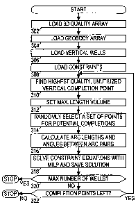
Fig. 7 shows a preferred method for determining optimal horizontal/deviated
well
completions. In blocks 302-304, the 3D reservoir quality array and the geobody
array
CA 02384810 2002-03-12
WO 01/23829 PCTIUSOO/25804
are retrieved. The vertical well locations from the vertical well placement
stage are
retrieved in block 306. The constraints are loaded in block 308. The
constraints include
maximum well length, maximum number of horizontal/deviated wells, and maximum
bending angle. Examples of other constraints which may also be used include
minimum
distance from a water or gas contact, total vertical relief allowed,
restricting the well to
always dip down or up from a starting location, distance from a platform,
distance from
a fault, total capital available.
In block 310, the method fmds the highest quality, unutilized vertical
completion
point. Any geobody cell in the column of cells where a vertical well is
located may be
chosen as a vertical completion point. That cell is unutilized if it does not
contribute to
the quality of a previously selected completion point.
In block 312, a volume is defined around the highest quality unutilized cell.
The
volume has a radius determined by the maximum well length constraint. In block
314, a
set of potential completion points is selected from this volume. Eliminated
from
candidacy as completion points are non-geobody cells and utilized cells. The
potential
completion points are selected randomly, and the number of points is limited
to some
maximum number (such as 100) in order to keep the complexity manageable. The
maximum is limited by the computer memory and processor speed. The number of
presolve calculations increases as n6; the number of binary variables
increases as n2, and
the number of constraint equations increases as n3, where n is the number of
selected
potential completion points.
In block 316, the lengths of all arcs between potential completion points in
the set
are calculated, and those arcs having lengths greater than the maximum well
length
31
CA 02384810 2002-03-12
WO 01/23829 PCT/USOO/25804
constraint are eliminated. The angles between all pairs of arcs are
calculated, and those
pairs having bending angles in excess of the constraint are labeled as
invalid. In block
318, the optimal solution to equations (2l)-(30) is found using mixed
integer/linear
programming (MILP). The optimal deviated well path is saved. In block 320 a
test is
made to determine if the maximum number of horizontal/deviated wells has been
reached. In block 322 a test is made to determine if any unutilized vertical
completion
points remain. If the another well is allowed and at least one completion
point remains,
then the method returns to block 310. Otherwise, the method terminates.
The formulations were written in GAMS (Generalized Algebraic Modeling System)
syntax. The models were solved using a parallel version of CPLEX. MIP solver
on any
Siticon Graphics SGI Onyx, and with a parallel version of the OSL solver on
an IBM
SP2. A graphical user interface (GUI) is preferably provided for handling the
data
volumes and running the geobody identification, reservoir quality calculation,
vertical
well placement, and horizontal well placement components separately as needed.
The
interface preferably allows the user to select high and low cutoff criteria,
six-point,
eighteen-point, or twenty-six point searches, and other parameters such as
drainage
radius for the proposed wells, well spacing, horizontal well length and
azimuth angle
restrictions.
Numerous variations and modifications will become apparent to those skilled in
the
art once the above disclosure is fully appreciated. For example, the maximum
bending
angle may be made a function of the arc length, e.g. 13 per 60 meters. It is
intended
that the following claims be interpreted to embrace all such variations and
modifications.
32