Note: Descriptions are shown in the official language in which they were submitted.
CA 02396086 2002-07-30
TITLE: Method And Device For The Measurement Of The Drift Of A Borehole
FIELD OF THE INVENTION
This invention relates to both a method and an apparatus to measure the drift
or
deviation of a well or borehole from vertical.
BACKGROUND OF THE INVENTION
When boreholes or wells are drilled into the earth for mining purposes, for
the drilling
of oil and gas wells, or for any one of a wide variety of other reasons, it is
generally
advantageous, or in some cases critical, to survey and record the progression
of the drill
bit and the position of the borehole in order to monitor bore drift and the
angle of
inclination of the well. The availability of a method and apparatus that
enables a drill
operator to map the progression of the well and to monitor the angle of its
inclination
is particularly important where there is a desire to drill into a specific
underground
formation. Knowing the location of the drill bit, and knowing the angle of
inclination
of the well relative to vertical, can also be extremely important when
drilling deep wells,
and in the case of oil and gas drilling where a large number of wells are
sometimes
drilled in a closely spaced configuration within a confined geographic area.
1
CA 02396086 2002-07-30
To assist drillers in monitoring and logging the inclination and progression
of a
borehole, others have devised and proposed a wide variety of different
measurement
devices. Such devices are generally capable of determining the location of a
portion of
a borehole or a drill bit relative to its surface entry point based upon a
defined coordinate
system. Most commonly a Cartesian coordinate system is utilized and centered
at the
wellhead with the "Z" axis defined as extending from the wellhead toward the
center of
the earth and the "X" and "Y" axes extending in a north-south and east-west
configuration, respectively. Typical devices that are currently in use for
surveying or
mapping a borehole comprise downhole tools or probes that contain instrument
packages capable of taking measurements and sending signals to equipment at
the
surface that can be used to plot the position of the borehole. The instrument
packages
of such tools or probes commonly contain gyroscopes, magnetic compasses,
pendulums,
accelerometers, and devices or sensors to measure the length of the borehole
from the
wellhead to the downhole tool.
While such devices have been in use for a considerable length of time, they
continue to
suffer from a number of inherent limitations and disadvantages, one of the
more
significant of which is their cost. In the drilling of oil and gas wells the
depletion of
relatively shallow and accessible hydrocarbon deposits has resulted in the
necessity to
drill deeper boreholes and to target smaller geographical formations. In deep
wells there
is an enhanced requirement for producing an accurate survey of the borehole as
even a
2
CA 02396086 2002-07-30
small degree of drift can become very significant over the span of several
thousand feet.
For this reason, the tools and probes that have been developed and that are
currently in
use tend to include instrument packages having relatively sensitive sensors.
Unfortunately while these sensors are designed to be reasonably accurate they
tend to
be susceptible to mechanical noise, which is relatively common in the downhole
environment where they are required to operate.
The effects of background or mechanical noise is particularly troublesome when
measuring small angles of drift or inclination. Accordingly, to offset the
effect of noise
and the error that noise can introduce into sensor readings, manufacturers of
existing
systems have resorted to using high quality (and hence expensive) sensors, in
conjunction with noise filters, to help minimize the noise effect and to help
to send a
"cleaner" signal to the surface. Such systems are inherently more complex,
present
increased opportunity for malfunction or breakdown, and can significantly
increase the
overall cost of the tool.
SUMMARY OF THE INVENTION
The invention therefore provides a method and an apparatus for the measurement
of the
drift of a well or borehole that is less susceptible to the effects of
mechanical noise,
particularly at small angles of measurement. The invention provides for such a
method
3
CA 02396086 2002-07-30
and apparatus that generally reduces the number of electronic components
required, can
be manufactured more easily and less expensively, and that is less susceptible
to
malfunction and mechanical breakdown.
Accordingly, in one of its aspects the invention provides a device for the
measurement
of the angle of drift of a borehole that extends from the surface of the
ground
downwardly into the earth, the device comprising; a generally hollow
protective exterior
casing; a microprocessor control; and, a sensor pack, wherein at least said
microprocessor control and said sensor pack are received and contained within
said
exterior casing, said sensor pack including one or more accelerometers mounted
upon
a sensor chassis that is positioned within said exterior casing and situated
generally
parallel to the longitudinal axis of said exterior casing, said sensor chassis
having one
or more mounting surfaces for receiving and securing said one or more
accelerometers
to said sensor chassis, said mounting surfaces configured such that said one
or more
accelerometers when secured to said chassis are held and retained at an
inclined angle
relative to the longitudinal axis of said exterior casing and said device.
In a further aspect the invention provides a tool for the measurement of the
angle of
inclination of a borehole extending into the earth, the tool comprising; an
elongate
casing; a microprocessor control; and, a sensor pack, wherein at least said
microprocessor control and said sensor pack are received and contained within
said
4
CA 02396086 2002-07-30
casing, said sensor pack including one or more electronic accelerometers, said
one or
more accelerometers including an inclination sensor mounted upon an electronic
circuit
board at an inclined angle such that said inclination sensor is positioned and
retained at
an inclined angle relative to the longitudinal axis of said casing and said
tool.
In yet a further aspect the invention concerns a method for measuring the
angle of drift
of a borehole that extends from the surface of the ground downwardly into the
earth, the
method comprising the steps of; situating and positioning within the borehole
a drift
measurement tool including a microprocessor control and a sensor pack, said
sensor
pack including one or more accelerometers mounted upon a sensor chassis having
a
longitudinal axis generally parallel to the longitudinal axis of said tool,
said one or more
accelerometers each including an inclination sensor, said sensor chassis
having one or
more mounting surfaces for receiving and securing said one or more
accelerometers to
said chassis, said mounting surfaces and said accelerometers together
configured such
that the inclination sensors of said one or more accelerometers, when said one
or more
accelerometers are secured to said chassis, are held and retained at an
inclined angle
relative to the longitudinal axis of said tool; applying a source of
electrical power to said
tool; and, causing the inclination sensors of said one or more accelerometers
to generate
signals corresponding to their angle of inclination that are sent to and
received and
stored by said microprocessor control.
5
CA 02396086 2002-07-30
Further aspects and advantages of the invention will become apparent from the
following description taken together with the accompanying drawings.
BRIEF DESCRIPTION OF THE DRAWINGS
For a better understanding of the present invention, and to show more clearly
how it may
be carried into effect, reference will now be made, by way of example, to the
accompanying drawings which show the preferred embodiments of the present
invention
in which:
Figure 1 is a pictorial view of a borehole having received therein a drift
measurement
tool in accordance with the present invention;
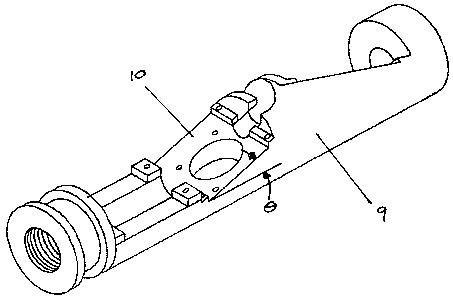
Figure 2 is a partially exploded and partial longitudinal sectional view of
the drift
measurement tool in accordance with one preferred embodiment of the invention;
and,
Figure 3 is an enlarged upper side perspective detail view of the sensor
chassis in
accordance with one preferred embodiment of the invention.
6
CA 02396086 2002-07-30
DESCRIPTION OF THE PREFERRED EMBODIMENT
The present invention may be embodied in a number of different forms. However,
the
specification and drawings that follow describe and disclose only some of the
specific
forms of the invention and are not intended to limit the scope of the
invention as defined
in the claims that follow herein.
The device in accordance with the present invention, which may generally be
referred
to as a drift measurement tool, is shown and identified in the attached
drawings
generally by reference numeral 1. In Figure 1 the drift measurement tool is
shown
pictorially as it may be used within a borehole 16 in conjunction with a
downhole drill
17. In a typical configuration tool 1 would be comprised of a generally hollow
protective exterior casing 2, a microprocessor control 4, a transmitter 5, and
a sensor
pack 6. As shown in Figure 2, tool 1 may also include a spear point or fish
end 13, and
anchor 14 and a series of stabilizing fins 15. To operate the sensors and
electronic
components of the tool, there is preferably provided a source of electrical
energy in the
form one or more batteries 7. Typically batteries 7 will be of an extended
life variety
(for example lithium batteries) in order to provide sufficient power to
operate the tool
for a considerable length of time. In other cases electrical power could be
supplied
through conductors extending downwardly from the surface to the tool or,
alternatively,
the tool could be fitted with a turbine and generator such that it is capable
of producing
7
CA 02396086 2002-07-30
its own electrical power.
To protect some of the more sensitive elements of the tool, at least the
microprocessor
control 4 and sensor pack 6 are received and contained within exterior casing
2.
However, in many instances it is expected that an elongate casing will be
utilized that
is sufficient in size to also house batteries 7 and transmitter 5. For
manufacturing,
assembly and maintenance purposes exterior casing 2 may be formed in a number
of
sections that are threaded or otherwise secured together in a fashion that
prevents in the
ingress of fluids and other debris into the interior of the casing.
In accordance with the invention sensor pack 6 includes one or more
accelerometers 8
that are preferably mounted upon a sensor chassis 9. The accelerometers
utilized in the
invention may be any one of a number of currently available accelerometers,
but are
preferably electronic accelerometers having an inclination sensor mounted on a
circuit
board. Sensor chassis 9 is situated and positioned within exterior casing 2
such that it
is generally parallel to the longitudinal axis of casing 2 and tool 1. Sensor
chassis 9
would typically be constructed from a rigid material that is suitable, from
both a strength
and thermal expansion standpoint, for general use in a borehole. In most cases
it is
expected that sensor chassis 9 will be formed from a metal or metallic
compound,
however, in some instances it may also be formed from a synthetic compound
having
a sufficient structural rigidity for downhole applications.
8
CA 02396086 2002-07-30
The physical configuration of sensor chassis 9 is such that it contains one or
more
mounting services 10 for receiving and securing to the chassis one or more
accelerometers 8. In the embodiment of the invention shown in Figures 2 and 3
mounting surfaces 10 are at an inclined angle (angle 0 in Figure 3)relative to
the
longitudinal axis of sensor chassis 9. In this manner when accelerometers 8
are secured
with their circuit boards attached to mounting surfaces 10 they will be held
and retained
at an inclined angle relative to the longitudinal axis of exterior casing 2,
tool 1, and the
borehole within which the tool is situated. With the accelerometer's
inclination sensors
perpendicular to their circuit boards, the inclination sensors will therefore
also be held
in an inclined orientation relative to the longitudinal axis of the tool. It
is expected that
in most instances mounting surfaces 10 would be inclined relative to sensor
chassis 9
at an angle from about 1 degree to 45 degrees, with a preferred range of
approximately
5 degrees to approximately 20 degrees.
In a further embodiment of the invention accelerometers 8 include inclination
sensors
that are mounted upon an electronic circuit board at an inclined angle. In
this
embodiment mounting surfaces 10 of sensor chassis 9 are parallel to the
longitudinal
axis of the chassis such that when the circuit boards of the accelerometers
are secured
to chassis 9 their circuit boards will be parallel to the axis of the chassis.
However,
since the inclination sensors of the accelerometers are inclined relative to
their circuit
boards, the inclination sensors will thus be retained at an inclined angle
relative to the
9
CA 02396086 2002-07-30
sensor chassis, the tool and the borehole within it is situated.
Regardless of whether tool 1 utilizes a sensor chassis with inclined
accelerometer
mounting surfaces, or whether the accelerometers are designed with inclination
sensors
mounted at an inclined angle relative to their circuit boards with the circuit
boards
mounted on the sensor chassis parallel to longitudinal axis of the chassis,
the end result
will be the same. In each case the inclination sensors will be positioned at
an inclined
angle relative to both the tool and the borehole. Since the inclination
sensors are
generally designed for vertical mounting, microprocessor control 4 will
contain software
to compensate and account for the inclination of the sensors within the tool.
Preferably two accelerometers 8 are utilized and positioned upon sensor
chassis 9 in
such a manner that their inclination sensors are in planes that are
perpendicular to one
another. In this fashion signals generated by the two accelerometers may be
used to
determine the degree of inclination of a borehole in the "X" and "Y"
directions in a
standard Cartesian coordinate system. However, it will be appreciated by those
skilled
in the art that depending upon the degree of accuracy required, the amount of
build-in
redundancy desired for an individual tool, and the level of sophistication
programmed
into microprocessor 4, one, two, three, or more accelerometers could equally
be used.
10
CA 02396086 2002-07-30
Referring again to Figure 2, in the embodiment of the invention that is shown
transmitter
is a pulsar 11 that transmits signals to the surface of the ground through mud
pulse
telemetry. Batteries 7 are used to power the pulsar, with the transmission of
signals
controlled by microprocessor 4. In this embodiment a transducer 12,
operatively
5 connected to the borehole at the surface of the ground, is used in
conjunction with pulsar
11. Typically in oil and gas well drilling applications transducer 12 would be
installed
in the standpipe above the borehole such that signals can be transmitted from
pulsar 11
to transducer 12 through well-known means of mud pulse telemetry. Signals
received
by transducer 12 may then be directed to surface analysis and/or recordal
equipment to
analyze the signals, plot or chart the position of the borehole, or calculate
the angle of
drift or inclination from vertical. It should be appreciated that in further
embodiments
of the invention signals may be transmitted from tool 1 to the surface of the
borehole by
wire line technology, electromagnetic telemetry, or acoustic telemetry.
The operation of tool 1 will now be described with respect to a scenario where
the tool
is in position in a well during a drilling operation. For illustration
purposes only, the
operation of tool 1 as set out below is described in conjunction with mud
pulse
telemetry. The operation of tool 1 will generally be same for embodiments that
utilize
wire line technology, electromagnetic telemetry, or acoustic telemetry.
11
CA 02396086 2002-07-30
In one embodiment of the invention the drift measurement tool includes a
vibration
sensor that is able to detect the cessation of drilling operations by means of
a lack of
vibration when the flow of drilling mud or fluid is stopped. When readings
from the
vibration sensor indicate that drilling has ceased, microprocessor control 4
will cause
accelerometers 8 to be queried and signals corresponding to the angle of
inclination of
the inclination sensors on the accelerometers will be generated by the
accelerometers
and received by and stored within the microprocessor. Accordingly, if a drill
operator
wishes to conduct a survey of the inclination of the borehole all that is
required is to stop
the drilling operation for a relatively short period of time, allowing the
vibration sensors
to activate microprocessor 4. The collection of data from the accelerometers
and the
storage of that data within the microprocessor will typically take from one to
two
minutes to complete, after which the pumping of drilling fluid or mud may be
reinstated
by the drill operator.
As the drilling processes resumes and mud once again starts to flow the
vibration sensor
will detect the flow of the mud and sends a signal to microprocessor control 4
which
then activates pulsar 11. The pulsar will then transmit the data received and
stored from
the accelerometers by means of mud pulse telemetry (generally referred to as a
tool
position signal). The data that is transformed into a positive pulse is seen
as an increase
in standpipe pressure at the surface and is captured by transducer 12. The
data may then
be directed to a chart recorder for printing or forwarded to surface equipment
for
12
CA 02396086 2002-07-30
analysis and subsequent recordal. Once the data has been received and recorded
at the
surface normal drilling operations may be resumed with tool 1 remaining in
place until
such time as a further survey is desired. After the pulsar has been activated
and transmits
the data to the surface the downhole tool will essentially enter a sleep mode
to conserve
power until again activated through a cessation of drilling operations and the
lack of
vibration as sensed by the vibration sensor.
By offsetting the inclination sensors of accelerometers 8 such that they are
at an inclined
angle relative to the longitudinal axis of the tool and the borehole, it has
been found that
the effects of mechanical noise (that are otherwise present when transducers
are
mounted perpendicular to the axis of interest) are significantly reduced. The
readings
and results from the tool have also been found to be considerably more
repeatable.
Accordingly, it has been found that through the described structure and method
lower
priced accelerometers can be utilized, without the need for expensive noise
filters. The
described structure and method has been found to be proficient in measuring
wellbore
drift angles to a resolution of approximately 0.25 degrees, and between a
range of 0
degrees to approximately 10.75 degrees without requiring adjustments to the
downhole
assembly. With an enhanced software programming the tool is capable of
measuring
drift up to 90 degrees. If desired, additional sensors may be placed within
tool 1 to
record other physical characteristics of the borehole with the corresponding
data
concerning those characteristics transmitted to the surface in a similar
manner.
13
CA 02396086 2002-07-30
It is to be understood that what has been described are the preferred
embodiments of the
invention and that it may be possible to make variations to these embodiments
while
staying within the broad scope of the invention. Some of these variations have
been
discussed while others will be readily apparent to those skilled in the art.
14