Note: Descriptions are shown in the official language in which they were submitted.
CA 02403124 2006-04-05
~
ARRANGEMENT FOR DETERMINING POSITION OF UNMANNED MINING
VEHICLES
BACKGROUND OF THE INVENTION
The invention relates to a method of determining the position of
unmanned mining vehicles, according to which method excavated mine galler-
ies are measured and control marks are provided In the mine galleraes, the
marks being used in controlling a mining vehicle.
The invention also relates to a measuring vehicle comprising a mo-
bile base, control devices for driving it unmanned in a mine from a control
room arranged outside a mine section to be operated, a data communication
unit for transmitting control and measurement information between the control
room and the vehicle, and at least one measuring device by which a mine gal-
iery is measured.
Mines are planned such that ore in the rock can be utilized as effi-
ciently as possible and that the mining is eff"icierrt_ Thus, a mining plan
and
map of a mine are prepared, according to which mine galleries are made.
Among others, the number, length, direction, inclination, ,pcgfiie.,~. of the
mine galleries are determined in advance_ The actual minin"Of,,s per-
formed in hard rock, for example such that a so-called fan is drilled in the
rock,
the fan having a required number of holes according to the driiling plan, the
holes being then charged with an explosive. A tunnel, for its part, is done in
so-
called rounds. The purpose is to separate a part of a desired direction and
depth from the rock by exploding, and a further aim is to form blocks of a
suit-
able size, which blocks can be handled, for example, by a loading vehicle to
be driven to the gallery. To keep the direction and dimensions of the mine gal-
leries as planned, control measurements have to be carried out at certain in-
tervals in the mine galleries. Conventionally measurements in a mine have
been carried out manually. Measuring persons thereby go and determine the
right direction of the tunnel by measuring, and simUarfy in the ore mining,
they
determine the location of the next fan to be drilled by using distance meas-
urement based on laser, for instance. Manual measurement is, however, slow
and the working in a mine may also be dangerous. After the performed rneas-
urements, positioning marks are marked, usually by a paint, on the walls of
the
mine gallery. The rock drilling apparatus is thus positioned at a mark in the
manner disclosed in the publication US 4,586,571, for instance. Light sources,
such as lasers, pointing to the sides of the rook drilling apparatus are thus
fix-
CA 02403124 2008-01-10
2
edly arranged at the apparatus, whereby the rock drilling apparatus is placed
at the fan to be drilled, such that the light beams of the light sources are
directed at the marks on the walls of the mine gallery. Alternatively, the
positioning is made as in the AU publication 700 301. The purpose is to make
sure that the mining of the ore continues according to the mining plan.
Furthermore, arrangements are known, which utilize a so-called
tunnel laser, i.e. a laser fixedly arranged in the gallery, and a prism/sight
arranged in the mining vehicle, or a laser arranged in the mining vehicle and
reference points, such as reflectors, correspondingly mounted fixedly at
predetermined places in the mine gallery. These solutions, however, always
require that a fixed infrastructure is built into the mine. Further, said
systems
are subject to various errors, wherefore their reliability in demanding mine
conditions is questionable.
Already in the near future, more and more unmanned production is
taken into use in mines. This refers to so-called teleoperated rock drilling
apparatuses, loading vehicles and other mining vehicles, which can be
controlled from an external, for example overground, control room by means of
video cameras, for instance. Furthermore, a so-called inertial navigation
device
known per se can be utilized in driving mining vehicles, the operation of
which
device being based on the gravitational fields of the earth. Such an inertial
navigator is otherwise a useful and exact device, but its disadvantage is a
high
price.
BRIEF DESCRIPTION OF THE INVENTION
It is an object of the present invention to provide a new kind of
solution for determining the position of unmanned mining vehicles in a mine
gallery.
The method of the invention is characterized by measuring the mine
by means of an unmanned measuring vehicle and by marking the control
marks by means of a marking device in the measuring vehicle.
Further, the measuring vehicle of the invention is characterized in
that the measuring vehicle comprises a marking device for marking control
marks onto the mine gallery in order to control other mining vehicles and
CA 02403124 2008-01-10
3
determine the position thereof.
Accordingly, there is provided a method of determining a position of
unmanned mining vehicle, the method comprising: measuring excavated mine
galleries by means of an unmanned measuring vehicle, marking control marks
in the mine galleries by means of a marking device in the measuring vehicle,
and using the control marks in controlling the mining vehicle.
There is also provided a measuring vehicle comprising: a mobile
base, control devices for driving the measuring vehicle unmanned in a mine
from a control room arranged outside a mine section to be operated, a data
communication unit for transmitting control and measurement information
between the control room and the measuring vehicle, at least one measuring
device by which a mine gallery is measured, and at least one marking device
for marking control marks onto the mine gallery in order to control other
mining
vehicles and determine a position thereof.
The invention provides the advantage that no fixed infrastructure
has to be built into the mine itself to control unmanned vehicles. Thus the
investment costs of the mine can be lower. Further, mining vehicles to be used
in the production need not necessarily be provided with measuring and
positioning means, such as with inertial navigation devices and the like, but
the
sensitive and expensive measuring devices are arranged in a separate
measuring vehicle. The invention also makes the mining faster, as the
operation in an unmanned mine need not be interrupted due to the mounting of
the marks, because the marking is carried out safely by means of an
unmanned teleoperated measuring device. It is relatively simple to provide the
measuring vehicle with the marking equipment of the invention, such as paint
sprayers, and it does not cause any significant additional costs. By using the
marking equipment, also location information can simultaneously be marked in
the mine gallery, the information being utilized in controlling the mining
vehicle.
An independently controllable mining vehicle has a reading device for reading
the location information, in which case the vehicle can be controlled and
positioned automatically.
CA 02403124 2008-01-10
3a
BRIEF DESCRIPTION OF THE DRAWINGS
The invention will be described in greater detail in the attached
drawings, in which
Figure 1 schematically shows a top view of a part of a mine, and
Figure 2 perspectively shows a mine gallery,
Figure 3 schematically shows a top view of a rock drilling apparatus
positioned in a mine gallery,
Figure 4 schematically shows a side view of a measuring vehicle
according to the invention in a mine gallery,
Figure 5 schematically shows a side view of a loading vehicle, and
Figures 6 and 7 schematically show some further embodiments.
DETAILED DESCRIPTION OF THE INVENTION
A part of a mine shown in Figure 1 comprises mine galleries 1
CA 02403124 2006-04-05
4
mined according to a pre-made mining plan, and a service gallery 2. Mine gai-
leries and parts of them, which are in accordance with the mining plan and are
not yet mined, are marked with a broken line 1' in the figure. The mine as
such
is fully known by a person skilled in the art, and therefore it is unnecessary
to
handle It in greater detail herein. An unmanned mine comprises a control room
1 a positioned in favourable conditions above the ground or elsewhere outside
the actual operating place., from where unmanned mining vehicles in the mine
are controiled. Thus, by using wireless data transmission there is a
connection
between the control room and the mining vehicle. Video pictures and meas-
urement infonnation, for instance, are transmitted from the mining vehicles to
the control room= by means of various measuring means arranged in the min-
ing vehicle, and, correspondingly, control information is transmitted from the
control room to the mining vehicles. As an example, the figure shows a meas-
-uring vehicle 3, a rock drilling apparatus 4 and a loading vehicle 5.
Thus, a specific teleoperated measuring irehicle 3 provided with the
required measuring means is used in an unmanned mine. The mine or the de-
sired parts of the mine are measured by means of the measuring vehicle,
whereupon a digital map of the realized mine can be formed by means of
computers in the control room and the map oan be compared with the mining
plan of the mine. The real state of the mine can thus be updated and potential
deviations can be noticed in time. The measuring vehicie comprises, for in-
stance, an inertial measuring device and ultrasonic scanners, which transmit
information on the basis of which a three-dimensional digital map of the mine
can be created. The measuring vehicle is shown in more detail later in Figure
4. According to the idea of the invention, the measuring vehicle is provided
with a marking device for making control marks in the mine galleries, on the
walls and/or roof of the mine gallery, for other mining vehicles. This is
illus-
trated in Figure 2 where the tunnel comprises positioning marks 6a to 6c. In
this case, the marks are circles painted on the surface of the rock. The
figure
3D also shows drill holes 7 to be charged.
Figure 3 shows a top view of an unmanned remote-controlled rock
drilling apparatus 4, and light sources 8a and 8b, such as lasers, pointing to
the side perpendicularly to the central axis of the rock drilling apparatus
are
fixedly arranged onto the base of the apparatus, on its both sides. The rock
drilling apparatus may also have light sources 8c pointing to the roof =of the
mine gallery and/or to the back wa'li of the mine gallery, for determining the
in-
CA 02403124 2006-04-05
~
clination angle of the rack drilling apparatus and further for determining the
transverse displacement of the apparatus in the mine gallery. The operator
drives the rock drilling apparatus in a remote-controlled manner into a mine
gallery to be operated and utilizes thereby pictures transmitted by a video
camera 9a arranged in the mining vehicle. Using the video cameras 9a to 90
directed forwards and to the sides, the operator sees the light beams transmit-
ted by the light sources Ba to 6c on the side and end wall of the gallery, and
on
the basis of this Information, the operator drives the rock drilling apparatus
such that the light beams hit the posltioning marks_ The rock drilling
apparatus
may alternatively have other kinds of sighting means, by which its position in
respect of the positioning marks can be observed. AU publication 700 301, for
instance, discloses a rock drilling apparatus, in which positioning lights men-
tioned eariier are repi.aced by a video camera or a corresponding optical sys-
tem. In order to position the rock drilling apparatus exactly, it is
sufficient that
the position of the vehicle is determined in respect of three positioning
marks.
The absofute inclination angle of the mining vehicle in respect of its
longitudi-
nai and transversal axes can be determined easily by means of, electrically
readable levels or similar levelling instruments. The mining vehicle is driven
to
the right vertical posifion by means of hydraulic supports, for example_
Figure 3 also shows a second set of light sources Ba' and Bb' and a
second set of cameras 9b' and 9c' in the rear part of the rock drilling appara-
tus, wheceby the same positioning marks can be utilized in the drilling of
more
than one rounds. Thus the interval between the measurements carried out by
the measuring vehicle in the mine gallery can be made longer.
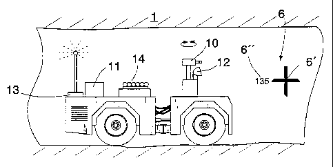
Ffgure 4 shows a measuring vehicle comprising a base that can be
moved independently, control means arranged on the base, and also means
for transmitting data between the measuring vehicle and a controi room- The
measuring vehicle may further comprPse at least one tumably arranged video
camera 10 whose pictures are transmitted to the control room. The vehicle is
driven in the mine mainly on the basis of the picfiureS from the video camera.
The mine can be measured by means of an inertial measuring device 11 ar-
ranged in the vehicle, and at least one scanner 12. The inertial measuring de-
vice produces continuous location information on the position of the measuring
vehicle in the mine. The shape of the mine gallery can be measured by means
of ultrasonic scanners or similar scanners. The measurement results are
transmitted by means of a data communication unit 13 to the control room of
CA 02403124 2006-04-05
6
the system, where the results can be processed by a computer. By using the
measuring vehicle, measurements can be carried out whenever required. After
the blocks have been exploded and transported away from the mine gallery by
a loading vehicle, the measuring vehicle is usually driven to this gallery and
the
new section of the formed gallery is measured. In this way, the control system
of the mine is updated.
A control mark 6 shown in Figure 4 comprises a positioning mark 6',
at which an aiming mark arranged in connection with the rock drilling appara-
tus to be. positioned, or a light beam is directed. At its simplest, the
positioning
mark is a cross painted on the surface of the rock. Alternatively, the mark
can
be a circle, as shown, for example, in Figures 2 and 5. When the light beam
hits inside the surface defined by the circle, the mining vehicle is
posi#ioned
accurately enough to the right position. As shown by Figures 4 and 5, in addi-
tion to the positioning mark, the control mark can also comprise other informa-
tion useful in controlling mining vehicles. Thus, there can be an
identification,
such as consecutive numbers painted on the rock surface, in connection with
it, whereby the operator in the control room of the system clearly sees from
the
video picture, which mark it is in which case. Furthermore, location
information
fi", such as altitude or coordinates, can be marked in connection with the
mark. The identification and location information 'can also be marked as a
code, which is read by means of a reader in the mining vehicle. A bar code
according to Figure 5, for instance, is suitable for this purpose, because it
can
be machine-read by means of an optical reader of the mining vehicle, such as
a scanner or a raster camera. The positioning marks can be painted by means
of sprays 14 arranged in the measuring vehicle. Although the painting of posi-
tioning marks is a means both simple and cheap, the marking can also be ar-
ranged in other ways, the shooting of coloured bullets and positioning means
based on transmitters, for instance, being mentioned herein. In the,last men-
tioned case, a suitable receiver is the reader.
Figure 5 shows a loading vehicle 5 by which the blocks are trans-
ported or loaded in order to be transported away from the mine gallery. Such
a vehicle also comprises a video camera 10 which transmits pictures from the
mine to the control room. The loading vehicle also comprises a reader 12 by
which the shapes of ;the mine gallery I and block heap 15 to be loaded are
read. Marks 6 made by the measuring vehicle can be utilized for determining
the position of the loading vehicie. On the basis of the picture conveyed by
the
CA 02403124 2006-04-05
7
video camera, the operator sees the positioning marks 6' and the
identiflcation
and/or location Information 6" in connecticm with them on the gallery walls.
The positioning marks can also be automatically read by means of
a reader, e.g_ a laser scanner, of the mining vehicle. whereupon the vehicle
can also be controlled entirely automatically by means of location information
in the marks. The reading of the marks can also be carried out by a raster
camera, or a video camera and an image processing program cannected to It.
The infarmation read from the marks is converted into electrical signals,
which
are supplied to a control unit 19 of the mining vehicle to be used as co.ntrol
pa-
rameters.
Figures 6 and 7 show a further embodiment in which the control
marks comprise mark sequences 16 painted by the measuring vehicle onto
the wall surfaces and/or roof of the mine gallery. The mining vehicle can be
made to follow such a mark sequence either from the control room by means
of a video camera, or the mining vehicle reads the mark sequence independ-
ently and follows it. Different driving routes=can be marked in the mine, for
in-
stance, by using a continuous/discontinuous mark sequence, by combining dif-
ferent mark sequences as In Figure 7, by using different colours and
reflecting
materials in the marking etc. A positioning mark 17, such as a transverse
lir~e
can be marked into the mark sequence 16. There can also be identifica-
tionRocation information 18 in connection with the mark sequence.
The drawings and the related description are only intended for illus-
trating the idea of the invention. In its details, the invention may vary
within the
scope of the claims. Thus, instead of fixed means, the mining vehicle may
comprise a turnable light source and a camera, which both have their prede-
termined.tuming positions in respect of the frame of the mining vehicle. They
can thus be tumed accurately to a right posltion to both sides of the vehicle,
directly forwards and, if required, perpendicularly upwards to the roof. Conse-
quently, compared with the snlution shown in Figure 3, It is sufficient to
have
one light source and one camera in one mining vehicle. In the corresponding
manner, paint sprayers or similar marking devices can be moved and con-
trolled in a variety of ways. Furthermore, when directing the drilling, the
control
system can comprise means which take into account potentfal deviations of
the drilling base from the accurate position defined by the posiaoning marks
and determine the compensated drilling directions.