Note: Descriptions are shown in the official language in which they were submitted.
CA 02411603 2002-11-12
METHOD FOR DETERMINING WELLBORE DIAMETER BY PROCESSING
MULTIPLE SENSOR MEASUREMENTS
BACKGROUND OF THE INVENTION
s Field of the Invention
This invention relates generally to a method and apparatus for determining the
size of
a borehole and, more particularly, to techniques for processing borehole size
measurements
obtained with downhole sensors to determine the borehole diameter. The
invention has
general application in subsurface exploration and production, but is
particularly useful in
~o while-drilling operations.
Description of Related Art
In order to improve oil, gas, and water drilling and production operations, it
is
necessary to gather as much information as possible on the properties of the
underground
i s earth formations as well as the environment in which drilling takes place.
Such properties
include characteristics of the earth formations traversed by a well borehole
and data on the
size and configuration of the borehole itself. Among the characteristics of
the earth
formation of interest to drillers and petrophysicists is the resistivity of
the rock or strata
surrounding the borehole. However, the processes often employed to measure
these
zo characteristics are subject to significant errors unless information on the
borehole size and
configuration is also taken into account in their determination. Knowledge of
the borehole
size is also useful to estimate the hole volume, which, in turn, is used to
estimate the volume
of cement needed for setting casing or when hole stability is of concern
during drilling.
The collection of downhole information, also referred to as logging, is
realized in
zs different ways. A well tool, comprising sources and sensors for measuring
various
parameters, can be lowered into the borehole on the end of a cable, or
wireline. The cable,
which is attached to some sort of mobile processing center at the surface, is
the means by
which parameter data is sent up to the surface. With this type of wireline
logging, it becomes
possible to measure borehole and formation parameters as a function of depth,
i.e., while the
3o tool is being pulled uphole.
1
CA 02411603 2002-11-12
An improvement over wireline logging techniques is the collection of data on
downhole conditions during the drilling process. By collecting and processing
such
information during the drilling process, the driller can modify or correct key
steps of the
operation to optimize performance and avoid financial injury due to well
damage such as
s collapse or fluid loss. Formation information collected during drilling also
tends to be less
affected by the drilling fluid ("drilling mud") invasion processes or other
undesirable
influences as a result of borehole penetration, and therefore are closer to
the properties of the
virgin formation.
Schemes for collecting data of downhole conditions and movement of the
drilling
io assembly during the drilling operation are known as measurement-while-
drilling (MWD)
techniques. Similar techniques focusing more on measurement of formation
parameters than
on movement of the drilling assembly are know as logging-while-drilling (LWD).
However,
the terms MWD and LWD are often used interchangeably, and use of either term
herein
includes both the collection of formation and borehole information, as well as
data on
is movement of the drilling assembly.
It is known in the art to measure the diameter, also known as the caliper, of
a borehole
to correct formation measurements that are sensitive to size or standoff.
These corrections
are necessary for accurate formation evaluation. U.5. Pat. No. 4,407,157
describes a
technique for measuring a borehole caliper by incorporating a mechanical
apparatus with
zo extending contact arms that are forced against the sidewall of the
borehole. This technique
has practical limitations. In order to insert the; apparatus in the borehole,
the drillstring must
be removed, resulting in additional cost and downtime for the driller. Such
mechanical
apparatus are also limited in the range of diameter measurement they provide.
Due to the unsuitability of mechanical calipers to drilling operations,
indirect
zs techniques of determining borehole calipers have been proposed for LWD
measurements.
Conventional LWD caliper measurement techniques include acoustic transducers
that
transmit ultrasonic signals for detection by appropriate sensors. U.5. Pat.
Nos. 5,469,736 and
4,661,933 describe apparatus for measuring the caliper of a borehole by
transmitting
ultrasonic signals during drilling operations. L1.5. Pat. No. 5,397,893
describes a method for
3o analyzing formation data from a MWD tool incorporating an acoustic caliper.
U.5 Pat. No.
2
CA 02411603 2002-11-12
5,886,303 describes a logging tool including an acoustic transmitter for
obtaining the
borehole caliper while drilling. U.S. Pat. No. 5,737,2?7 describes a method
for determining
the borehole geometry by processing data obtained by acoustic logging.
U.S. Pat. No. 4,899,112 describes a technique for determining a borehole
caliper by
s computing phase differences and attenuation levels from electromagnetic
measurements.
U.S. Pat. No. 5,900,733 discloses a technique for determining borehole
diameters by
examining the phase shift, phase average, and attenuation of signals from
multiple transmitter
and receiver locations via electromagnetic wave propagation. GB 2187354 A and
U.S. Pat.
No. 5,519,668 also describes while-drilling methods for determining a borehole
size using
io electromagnetic signals.
U.S. Pat. No. 5,091,644 describes a method for obtaining a borehole size
measurement as a by-product of a rotational density measurement while
drilling. U.S. Pat.
No. 5,767,510 describes a borehole invariant porosity measurement that
corrects for
variations in borehole size. U.S. Pat. No. 4,916,400 describes a method for
determining the
~s borehole size as part of a while-drilling standoff measurement. U.S. Pat.
No. 6,285,026
describes a LWD technique for determining the borehole diameter through
neutron porosity
measurements.
All of these subsurface measurement techniques are influenced by their
immediate
environment, and this influence has to be corrected to obtain an accurate
measure of the
zo undisturbed formation and borehole geometry. Thus it is desirable to obtain
a simplified
method for accurately determining the borehole shape and size. Still further,
it is desired to
implement a borehole size measurement technique that works for a wide range of
borehole
sizes and offers flexibility of measurement modes.
zs SUMMARY OF THE INVENTION
The invention provides a method for determining the size of a borehole
penetrating an
earth formation. The method comprises obtaining a plurality of borehole size
measurements,
each said measurement derived from one of a plurality of sensors that were
disposed within
said borehole; weighting each borehole size measurement with a factor
associated with said
3o measurement; and processing said weighted measurements to determine the
borehole size.
3
CA 02411603 2002-11-12
The invention provides a method for determining the size of a borehole
penetrating an
earth formation. The method comprises obtaining a plurality of borehole size
measurements
derived from a plurality of sensors that were disposed within the borehole,
said sensors being
adapted to make said measurements using different measurement principals;
determining a
s set of mathematical equations representative of the responses of said
plurality of sensors; and
solving said equation set to determine the borehole size.
BRIEF DESCRIPTION OF THE DRAWINGS
Other aspects and advantages of the invention will become apparent upon
reading the
~o following detailed description and upon reference to the drawings in which:
Figure 1 shows a general view of a measurement while drilling system including
one
example of a logging while drilling (LWD) instrument.
Figure 2 is a flow chart of one example of a process for determining the size
of a
borehole penetrating an earth formation according to the invention.
~s Figure 3 is another flow chart of another process for determining the size
of a
borehole penetrating an earth formation according to the invention.
DETAILED DESCRIPTION
A conventional LWD instrument and telemetry system is shown generally in
Figure 1.
zo A drilling rig including a derrick 10 is positioned over a wellbore 11,
which is drilled by a
process known as rotary drilling. A drilling tool assembly (drill string) 12
and drill bit 15
coupled to the lower end of the drill string 12 are disposed in the wellbore
11. The drill
string 12 and bit 15 are turned, by rotation of a kelly 17 coupled to the
upper end of the drill
string 12. The kelly 17 is rotated by engagement with a rotary table 16 or the
like forming
is part of the rig 10. The kelly 17 and drill string 12 are suspended by a
hook 18 coupled to the
kelly 17 by a rotatable swivel 19. Alternatively, the kelly 17, swivel 19 and
rotary table 16
can be substituted by a "top drive" or similar drilling rotator known in the
art.
Drilling fluid ("drilling mud") is stored in a pit 27 or other type of tank,
and is
pumped through the center of the drill string 12 by a mud pump 29, to flow
downwardly
30 (shown by arrow 9) therethrough. After circulation through the bit 15, the
drilling fluid
4
CA 02411603 2002-11-12
circulates upwardly (indicated by arrow 32) through an annular space between
the wellbore
11 and the outside of the drill string 12. Flow of the drilling mud lubricates
and cools the bit
15 and lifts drill cuttings made by the bit 15 to the surface for collection
and disposal.
A bottom hole assembly (BHA), shown generally at 100 is connected within the
drill
s string 12. The BHA 100 includes in this example a stabilizer 140 and drill
collar 130 that
mechanically connect a local measuring and local communications device 200 to
the BHA
100. In this example, the BHA 100 includes a toroidal antenna 1250 for
electromagnetic
communication with the local measuring device 200, although it should be
understood that
other communication links between the BHA 100 and the local device 200 could
be used as
io known in the art. The BHA 100 includes a communications system 150, which
provides a
pressure modulation telemetry transmitter and receiver therein. Pressure
modulation
telemetry can include various techniques for selectively modulating the flow
(and
consequently the pressure) of the drilling mud flowing downwardly 9 through
the drill string
12 and BHA 100. One such modulation technique is known as phase shift keying
of a
1 s standing wave created by a "siren" (not shown) in the communications
system 150. A
transducer 31 disposed at the earth's surface, generally in the fluid pump
discharge line,
detects the pressure variations generated by the siren (not shown) and
conducts a signal to a
receiver decoder system 90 for demodulation and interpretation. The
demodulated signals
can be coupled to a processor 85 and recorder 45 for further processing.
Optionally, the
ao surface equipment can include a transmitter subsystem 95 which includes a
pressure
modulation transmitter (not shov~m separately) that can modulate the pressure
of the drilling
mud circulating downwardly 9 to communicate control signals to the BHA 100.
The communications subsystem 150 may also include various types of processors
and
controllers (not shown separately) for controlling operation of the various
sensors disposed
Zs therein, and for communicating command signals to the local device 200 and
receiving and
processing measurements transmitted from sensors disposed on the local device
200. Sensors
in the BHA 100 and/or communications system 150 can also include, among
others,
magnetometers and accelerometers (not shown separately in Figure 1 ). As is
well known in
the art, the output of the magnetometers and accelerometers can be used to
determine the
3o rotary orientation of the BHA 100 with respect to earth's gravity as well
as a geographic
CA 02411603 2002-11-12
reference such as magnetic and/or geographic north. The output of the
accelerometers and
magnetometers (not shown) can also be used to determine the trajectory of the
wellbore 11
with respect to these same references (or another selected reference), as is
well known in the
art. The BHA 100 andlor the communications system 1 SO can include various
forms of data
s storage or memory which can store measurements made by any or all of the
sensors,
including sensors disposed in the local device 200, for later processing as
the drill string 12 is
withdrawn from the wellbore 11.
Conventional LWD measurements have enough redundancy to self correct for
errors
caused by the immediate environment. The magnitude of this self correction is
related to the
io borehole size, however this relationship to borehole size is strong or weak
depending on the
borehole size itself, and other environmental and formation related variables.
Generally speaking, the invention discloses a process for producing a single
LWD
merged caliper from the several indirect LWD borehole size measurements. This
merging
process accounts for the varying validity of each input borehole size
measurement as a
function of the environment, the formation, and the borehole size itself by
weighting level by
level each input with varying measurement confidence factors.
Each input borehole size measurement has its own measurement confidence factor
algorithm. This algorithm depends on the measurement principal, and
environmental and
formation parameters. These environmental and formation parameters can be
either LWD
zo measurements, or input parameters. In the event the measurement confidence
factors of the
borehole size measurements are similar, a set of spatial resolution factors
may be used to
weight the merged caliper towards the input with the highest resolution.
The invention is implemented by inverting a collection of signals or
measurement
data using model-dependent weightings. Suppose that we are given a collection
of sensors,
zs such as those used in conventional measurement tools, which are dependent
upon formation
parameters f = { f~, fz, . . . ~ as well as the borehole diameter b. Let TS(f,
(3) be the theoretical
response of the sensor Ts. as a function of these formation variables and
boreholes, then we
define a solution as
b = min ~ r~s (b) mine f TS - JTS ( f , ~3)~) , ( 1 )
R SEs
6
CA 02411603 2002-11-12
where cps (b) is the weighting for the sth sensor in a borehole b. The I~ II
indicate an
appropriate norm, such as the least-squares norm.
The above equation can be solved iteratively for b. Those skilled in the art
will
s appreciate that both standard and state-of the-art methods can be used to
compute, or
estimate, ~S (b) . For example, if we have a good understanding of the noise
in TS(f, ,Q) as a
function of ~3 we can use this to replace cus (b) with a function of that
noise estimate, which
we write as ~s (/.3) . This is a standard process in the Kalman filter
algorithm. In this case,
the caliper estimate is
io b = min~cos(,li)min~~~Ts- jTs( f,,Q)II . (2)
ses
An advantage of this expression is that the weighting terms used for the
minimization
do not depend upon the solution of that minimization. The weighting factors
may change as
a function of the borehole environment, as well as a function of the
measurement itself. For
~s example if the drilling mud is oil-based, or low salinity water-based,
certain types of
resistivity measurements could have a different weighting, The domain of
integration can
also be optimized to speed up the search. One possibility would be to restrict
the domain to a
level-by-level approach with the data from multiple BHA positions resampled so
that the
sensors have a common depth point. One could then make the assumption that the
caliper
zo was essentially the same over the interval that the BHA passed.
Alternatively, another
embodiment of the invention could be implemented with a scheme so that, say,
the borehole
size could only get bigger over the time interval that the BHA passed the
level. Another
embodiment could also be coded to minimize simultaneously for borehole caliper
and mud-
properties such as resistivity or density.
2s It will be apparent to those of ordinary skill having the benefit of this
disclosure that
the present invention may be implemented by programming one or more suitable
general-
purpose computers having appropriate hardware. The programming may be
accomplished
through the use of one or more program storage devices readable by the
computer processor
7
CA 02411603 2002-11-12
and encoding one or more programs of instructions executable by the computer
for
performing the operations described above. The program storage device may take
the form
of, e.g., one or more floppy disks; a CD ROM or other optical disk; a magnetic
tape; a read-
only memory chip (ROM); and other forms of the kind well known in the art or
subsequently
s developed. The program of instructions may be "object code," i.e., in binary
form that is
executable more-or-less directly by the computer; in "source code" that
requires compilation
or interpretation before execution; or in some intermediate form such as
partially compiled
code. The precise forms of the program storage device and of the encoding of
instructions
are immaterial here.
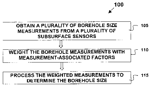
~o Figure 2 illustrates a flow diagram of a method 100 for determining the
size of a
borehole penetrating an earth formation. The method comprises obtaining a
plurality of
borehole size measurements, each said measurement derived from one of a
plurality of
sensors that were disposed within said borehole 105; weighting each borehole
size
measurement with a factor associated with said measurement 110; and processing
said
~ s weighted measurements to determine the borehole size 115.
Figure 3 illustrates a flow diagram of another method 200 for determining the
size of
a borehole penetrating an earth formation. The method comprises obtaining a
plurality of
borehole size measurements derived from a plurality of sensors that were
disposed within the
borehole, said sensors being adapted to make said measurements using different
zo measurement principals 205; determining a set of mathematical equations
representative of
the responses of said plurality of sensors 210; and solving said equation set
to determine the
borehole size 215.
The invention is not limited to using subsurface measurements made by the
particular
instruments or sensors described in any of the foregoing patents. It should be
clearly
~s understood that the invention is usable with borehole and formation
measurements acquired
with any suitable sensor adapted to detect subsurface signals. It will also be
apparent to those
skilled in the art that a number of techniques which do not depart from the
concept and scope
of the invention may be used to invert a collection of signals using model-
dependent
weightings to determine the borehole diameter.
g
CA 02411603 2002-11-12
For the purposes of this specification it will be clearly understood that the
word
"comprising" means "including but not limited to", and that the word
"comprises" has a
corresponding meaning.
9