Note: Descriptions are shown in the official language in which they were submitted.
CA 02413813 2002-12-27
WO 02/03740 PCT/USO1/20797
Method for Geo-Location Interpolation and Compression
Cross-Reference to Related Application
This application claims the benefit of U.S. Provisional Patent Application No.
60/215,740 filed on June 29, 2000.
Field
The invention relates to a locating system and moxe particularly, to a
geographic
position communication system that allows a transmission of compressed
geographic
position data.
Back~ound
Determining the geographical positions of mobile units has recently become
important for a wide range of applications. For example, a locater can be used
to locate a
stolen car, to provide security in transport of objects and to provide
direction services
through.which the location of, for example, the nearest gas station,
restaurant, or hospital
can be determined. In cellulax telephones, determining the geographical
position may help
subscribers in events such as a car failure, accident or crime.
While the cellular telephone can facilitate voice communication in these
situations,
the subscriber must first have knowledge of the subscriber's location.
Accordingly, many
techniques are being considered and developed to provide automatic location
capability.
The geograplucal location (hereinafter "geo-location") of a mobile unit can
then be
transmitted to a locater for application.
However, in many applications, the cost for transmitting data depends on the
amount of data passed. Therefore, transmitting the geo-location data using a
limited data
payload can reduce costs.
BRIEF SUMMARY OF THE INVENTION
The method and system allows a transmission of compressed geographical
location
~ data of mobile units to reduce the amount of data payload. Using a plurality
of references,
each having a reference positional data, a locater receives a compressed
positional data of a
mobile unit and determines the geographic position of the mobile unit. In one
embodiment,
CA 02413813 2002-12-27
WO 02/03740 PCT/USO1/20797
the locater determines the geographic position by comparing the compressed
position data
against a reference positional data.
Also, the method and system of transmitting compressed geographical location
may
be implemented into an existing system or references. For example, in one
embodiment, a
cellular network is used in transmitting the compressed geographical location
data. In one
embodiment, the geographical location of a mobile is determined using the
Global Position
System technology.
BRIEF DESCRIPTION OF THE DRAWINGS
The invention will be described in detail with reference to the following
drawings in
which lilce reference numerals refer to like elements wherein:
Figure 1 illustrates a geographical location communicating system in
accordance to
the invention;
Figure 2 illustrates a cellular network in accordance to the invention;
Figure 3 illustrates a roaming mobile unit in a cellular network in accordance
to the
invention; and
Figure 4 illustrates a geographical location interpolation procedure in
accordance to
one embodiment of the invention.
DETAILED DESCRIPTION
In the following description, specific details are given to provide a thorough
understanding of the invention. For example, some circuits are shown in bloclc
diagram in
order not to obscure the present invention in unnecessary detail. However, it
will be
understood by those skilled in the art that the present invention may be
practiced without
such specific details.
As disclosed herein, the term "mobile unit" refers to any remote device such
as a
cellular phone, cellular telephone equipment, or a beacon. The term "mobile
asset" refers to
any object capable of movement, such as a motor vehicle, a boat, or a bicycle.
The term
"transmission" refers to sending data over a communication line, and may
include both
wired and wireless transmission. The term "locater" refers to any positioning
server
2
CA 02413813 2002-12-27
WO 02/03740 PCT/USO1/20797
including, but not limited to an Application Service Provider (ASP). Also, the
term
"geographical position" and "geographical location" will be used
interchangeably.
Generally, transmission of less than the complete geographical position ("geo-
location") data of mobile units is achieved using a set of references. Here, a
set of
references already existing independently can be used to implement the
invention. By
refernng to the geographical location of a reference, the complete geo-
location of mobile
units can be recovered from transmissions of a compressed or reduced geo-
Location data.
Reducing the geo-location data of mobile units saves space and/or fits the
positional data
within an allowed size of a transmitted data payload, sometimes referred to as
a single data
packet.
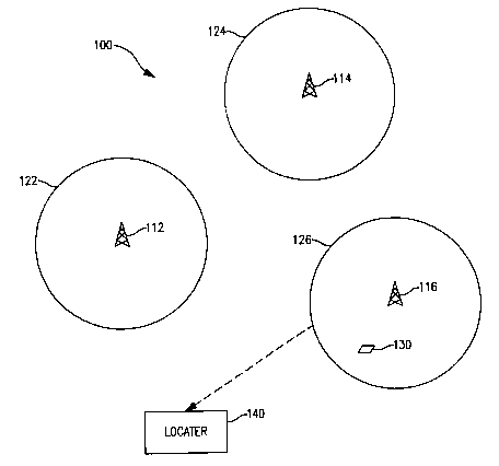
Figure 1 shows an exemplary embodiment of a geo-location communication system
100 in accordance with the invention including a plurality of references 112 ~
116, each
respectively covering a region 122 ~ 126. Although the regions 122 ~ 126 are
shown to
cover an area in the shape of circles, the regions 222 ~ 126 may be in any
shape including
but not limited to a square, a rectangle and a hexagon. Also, the references
112 ~ 116 are
stationary with fixed geo-locations to be determined and set as reference
positional data.
A locator I40 receives a compressed geo-Location data of a mobile unit I30 and
a
reference data corresponding to the reference 116 covering the region 126
which contains
the mobile unit 130. The compressed geo-location data may be sent to the
locator 140 by a
wireless or wired transmission. The reference data corresponding to the
reference 116 may
also be sent by a wireless or wired transmission.
In one embodiment, the reference data may be an assigned identification (ID)
code
of the reference 116. For example, a unique ID code can be assigned to each
reference 112
116 and stored with the corresponding reference positional data at the locater
240. Since
the reference positional data for each reference may be predetermined, when a
locater 140
receives ;an ID code with the compressed geo-location data of a mobile unit
130, the
reference positional data can be obtained using the ID code. In another
embodiment, the
reference data may be the reference positional data of a reference, in which
case the
reference positional data need not be stored at the locater 140. In such case,
the reference
positional data may also be predetermined and stored at each corresponding
references.
Moreover, in some applications, as will be discussed in more detail below, the
reference
3
CA 02413813 2002-12-27
WO 02/03740 PCT/USO1/20797
data may be a parameter that is automatically transmitted within a system as
part of the
normal operations.
Vyhen the reference positional data of the reference 116 is obtained using the
received reference data, the locator 140 recovers the complete geo-location
data of the
mobile unit 130 using the received compressed geo-location data. The
particular methods
to recover the complete geo-location data vary based upon the method used to
compress the
geo-location data. Namely, there may be many ways to compress the geo-location
data of a
mobile unit in accordance with the invention, one of which is to compress the
geo-location
data of a mobile unit by truncation based upon the differences in positions
among the
references.
Generally, if the positional difference between two references is
approximately x
number of digits, the geo-location of a mobile unit needs to be determined to
the nearest x
number of digits. The rest can be recovered from the reference positional
data.
Accordingly, the digits left ofx number of digits) may be truncated in the geo-
location data
of the mobile unit. For example, assume that a reference positional data of
the reference
112 in Figure 1 is 165 in measured units, a reference positional data of the
reference 116 is
173 units, and a geo-location data of the mobile unit 130 is 17I. Since the
positional
difference between the references 112 and 116 is 8 units, the digits left of
the least
significant digit can be truncated. Therefore, the least significant digit of
"1" is the
compressed geo-location data of the mobile unit 130 and is transmitted to the
locater 140.
Thereafter, the complete geo-location data of the mobile unit can be recovered
using the
reference data.
As there may be many ways to compress the geo-location data of a mobile unit,
there may also be more than one method to recover the complete geo-location
data from the
geo-location data compressed by truncation. In one embodiment, an iterative
comparison is
used to interpolate and recover the complete geo-location of mobile units. The
comparison
is between the truxzcated geo-location data of a mobile unit and the reference
positional data
corresponding to the reference data received. In the given example, the
reference data
corresponding to the reference I 16 would be received since the mobile station
130 is within
the region 126 covered by the reference I 16. Accordingly, the least
significant digit "3" of
the reference positional data 173 is compared with the truncated geo-location
data of "1."
4
CA 02413813 2002-12-27
WO 02/03740 PCT/USO1/20797
In the comparison, if there is no match, the value of the reference positional
data is
adjusted and re-compared with the truncated geo-location data of "1" until a
match is found.
Tn one embodiment, the reference positional data is adjusted as follows, in
which the
reference positional data is incremented and decremented by a predetermined
unit.
Assuming a predetermined unit of "I," a unit of "1" is added to the reference
positiorial data and the resulting least significant digit "4" of 174 is
compared
with the truncated data of "I ." No match. Subtracting "1" unit, the least
significant digit "2" of 172 is compared with "1." No match. Adding "2" units,
the least significant digit "5" of 175 is compared with "1." No match.
Finally,
subtracting "2" units, the least significant digit "1" of 171 is compared with
"1"
and a match is found.
The geo-location of the mobile unit 130 is then determined as 171 units.
Although the system and method of locating a mobile unit as described above
generates a fairly efficient and accurate result, an error checking procedure
may further be
implemented to improve the accuracy of the determined geo-location. In one
embodiment,
the error checking procedure checks the geo-location of a mobile unit to
determine if the
interpolated geo-location of the mobile unit falls within the boundary of the
region covered
by the reference corresponding to the reference data received. Continuing with
the example
above, the interpolated geo-location of the mobile unit 130, i.e. 171 units,
is checked to
determine if it falls within the boundary of the region 126 covered by the
reference 116.
Since the area of the region covered by each reference can be approximated,
the boundary
of each region may be predetermined. In determining the boundary, the area of
each region
can be overestimated or underestimated to achieve a lower or higher confidence
level for
the error-checking procedure.
By reducing the amount of information that is transmitted to a locater, the
invention
can be integrated in a wide variety of systems and applications that require a
transmission of
geo-location data using a limited data payload.
Figure 2 shows one of many possible implementations of the invention, in which
a
cellular network 200 is used to transmit the compressed geo-location data of
mobile units.
The cellular network 200 includes a plurality of cellular systems 212 ~ 2I4,
each having an
CA 02413813 2002-12-27
WO 02/03740 PCT/USO1/20797
assigned system identification (SID) code and each respectively covering a
region 222
224. Generally, a cellular system in which a mobile unit is registered is the
home system of
the mobile unit. When a mobile unit is activated, the SID of the system in
which the mobile
unit is operating is broadcasted as part of the normal operations in order to
service the
mobile unit. If the mobile unit is operating outside of its home system, the
mobile unit is
said to be "roaming."
Figure 3 shows an example of a roaming mobile unit 310 in the cellular network
200. Messages from the mobile unit 310 are received by a base station 320 and
processed
by a visiting location register (VLR) of a mobile switch center (MSC) 330. The
VLR 330
forwards a data payload, including an Electronic Serial Number (ESN) of the
mobile unit
310, the SID and the compressed geo-location data, to a home location register
(HLR) of a
MSC 350 through Signaling System 7. Here, the ESN is a code assigned to
uniquely
identify the mobile unit 310. The HLR 350 processes and re-transmits the data
to an ASP
360 to provide the service required by the mobile unit 310. Note, that if a
mobile unit were
operating within its home system, the SID would be known. Hence, the ESN and
the
compressed geo-location data may be transmitted to the HLR 350 through a base
station
370. Figure 3 is an exemplary application of system and method to transmit
compressed
geo-location data using one base station and one mobile unit, various
combinations of base
stations and mobile units may be used without departing from the spirit and
scope of the
invention.
Referring back to Figure 2, if a mobile unit 230 is activated, the SID of the
system
214 and the compressed geo-location data of the mobile unit 230 would be
received by an
ASP 240 through a data cloud 250 as described above. Moreover, the geo-
location for each
SID is stored at the ASP 240 as part of the system operation. Accordingly, the
SID is used
as the reference data and the ASP 240 can extract the geo-location data
associated with the
SID to be used as the reference positional data. The ASP 240 can then
determine the
complete geo-location data of the mobile unit 230 from the geo-location data
using the
reference positional data.
By using the SID as the reference data, additional data for use as the
reference data
need not be sent in the data payload for determining the geo-location of a
mobile unit.
Therefore, the reference data need not be sent in the data payload. Moreover,
in cellular
6
CA 02413813 2002-12-27
WO 02/03740 PCT/USO1/20797
systems, the data payload is transmitted through different channels. Control
channels are
used to initiate a call and a voice channel is used after a call is initiated.
Although any
channel can be used, in one embodiment, the data payload including the
compressed geo-
location'data is transmitted as part of the overhead using a control channel.
The
compressed geo-location data may also be transmitted within the ESN or within
the digits
dialed by a mobile unit. While the above cellular system has been described
using the S:Q7
as the references, other information can be used as such as a cell cite within
a cellular
system or the point code of equiprnents such as the HLR, the VLR or the MSC
that
transports the data.
Furthermore, one of many ways by which a mobile unit can determine its geo-
location is by using the Global Positioning System (GPS) technique. GPS is a
constellation
of 24 satellites that makes it possible for GPS receivers to determine their
geographic
location. Generally, each satellite continually broadcasts its changing
position and time and
a GPS receiver triangulates its geographic location by receiving bearings from
three
satellites. The result is provided in units of latitude and longitude. Using a
fourth satellite,
the receiver can also determine altitude as well as the geographic position.
In one embodiment which implements the GPS in the cellular network 200 above,
a
mobile unit is a GPS receiver and obtains its geo-location data from the GPS
in units of
latitude and longitude. The latitude and longitude reported by the mobile unit
each contains
1 digit of the degree portion. For instance, if the latitude is 23 degrees,
the second 3 will be
reported and if the longitude is -117, the 7 will be reported. Digits
representing the minutes
of the latitude and longitude are completely reported. Thus, the ASP 360 of
Figure 3
determines the most significant digit of the latitude and the 2 most
significant digits of the
longitude. These can be determined because the SID is also contained in the
data the ASP
360 receives from the HLR 350. Based on how finite and precise the reference
is, the less
or more digits can sometimes be interpolated.
For example, the difference in latitude across regions typically covered by a
cellular
system in the United States is approximately 2 degrees. Therefore, the ASP
need to
determine the latitude to the nearest 10 degrees. The rest is recovered
through the SID or
the reference. This is the same for the longitude.
7
CA 02413813 2002-12-27
WO 02/03740 PCT/USO1/20797
Accordingly, when a message comes in, the ASP starts with the latitude and the
longitude of the reported SID, namely the reference positional data. The
reported latitude,
i.e. the truncated geo-location data, is checked against the least significant
degree digit
(LSDD)'of the reference positional data. If the digits match, the reference's
more
significant digits are the same as the mobile unit's. Otherwise, the LSDD of
the reference
positional data is incremented and/or decremented in units of 1 degree until a
match is
found. The same process is repeated for the longitude.
Figure 4 shows one embodiment of the interpolation procedure 400 to determine
the
geo-location data of a mobile unit. The LSDD of the reference positional data
is checked
against the reported geo-location data (block 410). If there is no match, a
determination is
made whether the increment/decrement unit of N is odd (blocks 420 and 430).
The value of
N is initially set 1. If N is odd, N is added to the LSDD (block 440).
Otherwise, N is
subtracted from the LSDD (block 450). Thereafter, the value of N is increased
by I (block
460) and the LSDD is checked against the reported geo-location data (block
410). If there
is a match, the process ends. The more significant degree digits of the
reference positional
data are determined to be the same as the mobile unit's.
For example, assume an approximate location for SID number 00488 in Provo,
Utah
is 40 degrees 13.66 minutes North latitude and 111 degrees 39.12 minutes West
longitude.
A mobile unit roughly 20 miles south of Provo on Interstate I5 would report
something like
9 degrees 58.30 minutes latitude and I degree 48.OO~minutes longitude. Looking
first at the
longitude, the reported I degree matches the third 1 in I 11 degrees. The ASP
would then
determine that the mobile unit's longitude is 111 degrees 48 minutes West.
Turning to the
reference latitude of 40 degrees, 0 does not equal 9. Therefore, adding a
value of 1 to the
reference latitude yields 41 degrees. Since 1 does not equal 9, a value of 1
is subtracted
from the original reference latitude yielding 39 degrees. Here, the LSDD of
the reference
latitude matches 9 and the latitude of the mobile unit is determined as 39
degrees 58.30
minutes North.
In the interpolation procedure 400, the LSDD can first be decremented and then
incremented to be compared against the reported geo-location data.
Alternatively, the
LSDD can simultaneously be incremented and also decremented, in which case an
incremented LSDD and a decremented LSDD would be compared against the reported
geo-
CA 02413813 2002-12-27
WO 02/03740 PCT/USO1/20797
location data. Furthermore, if an error checking procedure has been
implemented, the ASP
would check whether the mobile unit falls within the region covered by the S)D
number
00488.
As described above, reduced geo-location data of mobile units can be
transmitted to
a locater and recovered using reference positional data. Moreover, the system
and method
for transmitting the reduced geo-location data can easily be implemented using
a system of
references already existing, such as the cellular network. Therefore, the geo-
location
communication system and method in accordance with the invention can be
applied in a
wide range of application.
A tracking and communication device is one application in which the present
invention can be implemented. A mobile unit can be installed in a mobile asset
such as an
automobile to track the vehicle's location using, for example, the GPS
technology. When
polled by a user, the vehicle's location may be reported using mobile unit in
the form of
compressed geo-location data. Here, the cellular network can be used, as
described above.
For example, the mobile unit reports its geo-location when a driver activates
a signal to
notify a service center that the driver needs roadside assistance. Also, an
alarm system can
monitor the vehicle's alarm system to notify a service center that the alarm
has been
activated and to give the geo-location. In still another embodiment, the
mobile unit can
actively broadcast its geo-location in predetermined intervals without being
polled by a
user.
While several examples uses and implementation of the invention have been
described, it will be understood by one of ordinary skill in the art that the
invention is not
limited to these uses. For example, the present invention can be used for
locating the
position of mobile units in air andlor sea. Therefore, the foregoing
embodiments are merely
exemplary and are not to be construed as limiting the present invention. The
present
teachings can be readily applied to other types of apparatuses. The
description of the
present invention is intended to be illustrative, and not to limit the scope
of the claims.
Many alternatives, modifications, and variations will be apparent to those
skilled in the art.
9