Note: Descriptions are shown in the official language in which they were submitted.
CA 02414631 2002-12-23
WO 02/03099 PCT/USO1/20344
1
METHOD FOR IMAGING DISCONTINUITIES
IN SEISMIC DATA USING DIP-STEERING
s FIELD OF THE INVENTION
This invention relates generally to the field of geophysical prospecting.
More particularly, the invention is a method of identifying structural and
stratigraphic discontinuities in a three-dimensional (3-D) seismic data volume
to containing dipping reflectors.
BACKGROUND OF THE INVENTION
As part of the hydrocarbon exploration and production work process,
is geoscience interpreters often need to recognize and map subsurface
structural features, such as faults, and stratigraphic features, such as
channel- or sand-body edges, in three-dimensional seismic data. However,
identifying structural and stratigraphic features in 3-D seismic data can be a
time consuming, subjective, and difficult process. There is a need to
2o generate, in a computationally efficient matter, a derivative data volume
(i.e.,
a data volume derived from the original seismic data volume), that displays
clear, sharply focussed structural and stratigraphic features that can be
quickly recognized and exploited in the mapping process.
Several techniques have been used in the oil industry to enhance the
2s interpretation of structural and stratigraphic features in 3-D seismic
data. A
well-known technique is to transform the original amplitude data into a
coherence volume using a series of one-dimensional cross-correlation
calculations. For every data sample in a volume, the cross-correlation
calculation is performed using a user-defined vertical window with the
so equivalent portion of an adjacent trace. Typically, the vertical window is
the
target sample in question, plus 3-7 data samples above and below the target
sample, depending upon the frequency of the data. This operation is
CA 02414631 2002-12-23
WO 02/03099 PCT/USO1/20344
2
repeated for all data samples and all traces, all in the same correlation
direction. The correlation direction is generally in-line, cross-line, or
either
diagonal direction. The resulting coherence volume typically contains values
normalized between -1 and +1. For adjacent tr aces that are very similar, the
s value of the coherence sample will be close to +1, since +1 represents high
correlation. This similarity, and hence correlation, is expected for adjacent
traces that do not straddle a structural or stratigraphic discontinuity. For
adjacent traces that do straddle a discontinuity, lack of similarity is
expected.
Thus, their coherence value would be closer to 0, since 0 represents no
lo correlation. A coherence value of -1 represents negative correlation, such
as
high correlation with phase reversal. Alternatively, coherence can be
described with the inverse notion of discontinuity, in which low coherence
equals high discontinuity and high coherence equals low discontinuity. In
either case, this standard technique has limitations, though, because features
is perpendicular to the single correlation direction are highlighted, while
features
parallel to the correlation direction are poorly imaged.
Normally the cross-correlation calculations are conducted parallel to
time slices. This direction of calculation can create problems if the seismic
data volume contains reflections that dip significantly, because a calculation
2o that is conducted parallel to a time slice searches across the dipping
reflections. When a cross-correlation calculation searches across dipping
reflections, it identifies poor correlation because it is comparing different
parts
of the seismic wavelet. It may then map low coherence or high discontinuity
to the coherence volume, even where dipping reflections are continuous.
2s Dip-steering reorients the search in a cross-correlation calculation so
that it is conducted parallel to dipping seismic reflections. Once dip-
steering
re-orients the search parallel to dipping reflections, the calculation
compares
the same parts of the seismic wavelet, and is able to correctly assign high
correlation or low discontinuity to continuous reflections. If these
reflections
so are cut by a discontinuity such as a fault or channel margin, this
discontinuity
is imaged much more clearly because of the contrast to the continuous
reflections.
CA 02414631 2002-12-23
WO 02/03099 PCT/USO1/20344
3
Prospective hydrocarbon reservoirs often have steep dips because
they often are located at anticlines or inclined fault blocks. Dip-steering
provides better images of discontinuities in these prospects. This enhances
the ability to add reserves or make discoveries and produce complexly faulted
s traps. Easier and more efficient interpretation of complex fault networks
should lead to cost reduction and performance improvement.
Bahorich and Farmer received U.S. Patent No. 5,563,949, "Method of
Seismic Signal Processing and Exploration", issued Oct. 8, 1996. This patent
is commonly known as the "coherence cube" patent. Bahorich and Farmer
to also obtained a continuation of this patent in U.S. Patent No. 5,838,564,
"Apparatus for Seismic Signal Processing and Exploration", issued Nov. 17,
1998.
Bahorich and Farmer's '949 patent describes a method for converting a
fully processed 3-D seismic data volume into a cube of coherence
zs measurements. According to their method, the 3-D data volume is divided
into a plurality of horizontal slices, and each horizontal slice is further
divided
into a plurality of cells, each of which contains portions of at least three
seismic data traces. As described in the '949 patent, these at least three
traces in each cell comprise a reference trace, an in-line trace, and a cross-
2o fine trace. The in-line trace and the cross-line trace are each compared to
the
reference trace in each cell using a measure of coherency. Then the in-line
and cross-line coherency measures are combined to obtain a single value that
is representative of the coherence of the three seismic traces for each cell.
This process is repeated for every cell, using every trace in the 3-D seismic
2s volume as a reference trace, in order to obtain a 3-D cube of coherence
measurements. Bahorich and Farmer's '564 patent describes the
corresponding apparatus for carrying out the process of their '949 patent.
Bahorich and Farmer's patented technique combines information from
more than one correlation direction at each data sample in the 3-D seismic
3o data volume, thereby highlighting structural and stratigraphic information
along multiple azimuths. According to Bahorich and Farmer, in their invention
"the concept of cross-correlation is extended to two dimensions by taking the
CA 02414631 2002-12-23
WO 02/03099 PCT/USO1/20344
4
geometric means between the classical one dimensional cross-correlations"
(U.S. Patent 5,563,949, column 4, lines 17-20). This technique has
limitafiions, however. Combining information from difFerent correlation
directions may effect the image clarity of the structural and stratigraphic
s features. This decrease in clarity can make it more difficult to extract
structural and stratigraphic information. in automated mapping processes. In
addition, the computational complexity of this procedure is significantly
greater
than the traditional method using classical one-dimensional cross
correlations. Further, Bahorich and Farmer's '949 and '564 patents do not
to fake info account the presence of reflection dip in the seismic data.
Higgs and Luo received U.S. Patent No. 5,724,309 "Method for
Geophysical Processing and Interpretation Using Instantaneous Phase and
Its Derivatives and Their Derivafiives", issued Mar. 3, 1998. Higgs and Luo's
'309 patent describes a related technique for interpretation of faults and
is stratigraphic features. The technique uses instantaneous phase and its
spatial derivatives to determine values of spatial frequency, instantaneous
frequency, dip magnitude and dip azimuth. These values are plotted to
produce a derivative seismic volume that highlights subsurface changes. The
main advantage of this technique is its computational speed. However, the
2o instantaneous phase and frequency images tend to be of lower resolution
than traditional amplitude-derived cross-correlation images. A similar
technique was also published by Hardage et al., 1998, "3-D Instantaneous
Frequency used as a Coherency/Continuity Parameter to Interpret Reservoir
Compartment Boundaries Across an Area of Complex Turbidite Deposition",
2s Geophysics, Vol. 63, No. 5, pp. 1520-1531. This technique uses
instantaneous frequency images to define reservoir compartments by
identifying facies boundaries. Neither of these two techniques discusses how
to compensate for the presence of reflection dip in coherency calculations.
Gersztenkorn's International Patent Application No. PCT/US97/00249,
so "Method and Apparatus for Seismic Signal Processing", was published as
International Publication No. WO 97/39367 on Oct. 23, 1997. This technique
generates a covariance matrix for an ensemble of seismic traces and then
CA 02414631 2002-12-23
WO 02/03099 PCT/USO1/20344
estimates the degree of similarity between traces by estimating the largest
eigenvaiue of the covariance matrix. It identifies the maximum coherence
component and therefore identifies structural and stratigraphic
discontinuities
in the data at all azimuths. The main disadvantage is that because this
s technique estimates eigenvalues of the covariance matrix for each time
sample in the volume, if is computationally intensive. This method discloses
another form of continuity calculation, but it does not compensate for the
presence of reflection dip.
Marfurt, Kirlin, Farmer, and Bahorich received U.S. Patent No.
io 5,930,730 "Method and Apparatus for Seismic Signal Processing and
Exploration", issued July 27, 1999. The '730 patent describes a method for
identifying structural and stratigraphic features in three dimensions in the
presence of reflection dip. After datumming is applied to remove a significant
portion of the regional structural dip, a semblance calculation is applied as
a
Is function of time to multiple seismic traces in multiple directions to
further
estimate and correct for local dip. A maximum semblance cube is created
that highlights structural and stratigraphic discontinuities, corrected for
structural dips. Improved imaging is obtained in areas of higher structural
dip
and seismic noise. Unfortunately, this method is very computationally
2o intensive.
Marfurt, Sudhaker, Gersztenkorn, Crawford, and Nissen have used a
version of dip-steering for coherency calculations in their paper in
Geophysics, Vol. 64, No. 1, pp. 104-111, Jan-Feb 1999, "Coherency
Calculations in the Presence of Structural Dip". The technique described in
2s this publication examines the similarity of multiple traces at various time
lags
to estimate the dip of reflectors. The x and y components of apparent dip are
estimated at each point in the seismic data cube using a "semblance-based"
algorithm. This algorithm calculates the semblance along various test
dip/azimuth pairs and identifies the dip as that with the greatest calculated
3o semblance. This estimate of dip is smoothed by either calculating its mean,
median, or alpha-trimmed mean over a window approximately 10 times larger
than the original window to obtain smooth apparent dip in the x and y
CA 02414631 2002-12-23
WO 02/03099 PCT/USO1/20344
6
directions. This step is intended to overcome the fact that some value of dip
will be found across faults that does not correspond to the dip of the
reflections on either side of the fault. After application of this filter, the
adjacent reflection dips should dominate at the fault. These dip values are
s used to flatten the data and calculate coherency. An eigenvalue algorithm is
used to calculate the similarity of traces in the locally averaged dip
direction.
The main advantage of this approach is the minimization of coherency
artifacts due to the dip of reflectors and thus a sharpening of the image.
However, this approach can be computationally intensive.
to Sequence stratigraphy models the interplay of sedimentation, sea-level
change, and subsidence in a geological setting. P. R. Vail et al. have
described the importance of seismic sequence analysis to structural and
stratigraphic interpretation in their paper "Seismic Stratigraphy and Global
Change of Sea-level", AAPG Memoir 26, 1977. In stratigraphic interpretation,
is reflection patterns are the clues used to reconstruct the depositional
environment. During the process of determining the depositional sequence,
geologists often use seismic data to interpret stratigraphic horizons.
Pattern recognition and image processing have also been applied to
automatic tracking of seismic horizons. Y. C. Cheng and S. Y. Lu have
2o described a procedure called seismic skeletonization in their paper "The
Binary Consistency Checking Scheme and its Applications to Seismic Horizon
Defection", IEEE Transaction on Pattern Analysis and Machine Intelligence,
Vol. II, No 4, 1989. In that paper, a correlation based on the similarity of
seismic reflectors in the adjacent traces was used to extend the reflectors
2s laterally. This procedure then fits straight-line segments to the
continuous
connected reflectors. The procedure goes further to employ a sorting process
on the straight-line segments so that the bedding sequence of seismic
reflectors would follow the rule of superposition in which younger beds lie on
top of the older beds. The seismic skeletonization procedure also uses an
3o iterative approach. Strong reflectors are tracked first, and then weak
reflectors are tracked at the later iterations. The geological trend is thus
incorporated into the result.
CA 02414631 2002-12-23
WO 02/03099 PCT/USO1/20344
7
It can be seen from the foregoing that a need exists for a
computationally efficient and accurate method for identifying structural and
stratigraphic features in 3-D seismic data in the presence of reflection dip.
s SUMMARY OF THE INVENTION
The present invention is a method for detecting structural and
stratigraphic discontinuities in a volume of seismic data samples in the
presence of reflection dip. A primary and at least one secondary direction are
to selected in the volume of seismic data samples. Skeleton patches are
identified in the volume of seismic data samples in the primary and secondary
directions. The skeleton patches comprise groups of connected seismic
samples representing seismic horizons in the volume of seismic data
samples. Apparent dip is calculated in the primary and secondary directions
is at each data sample within these identified skeleton patches. This creates
a
primary direction dip volume and at least one secondary direction dip volume,
respectively, at corresponding data sample locations. A filter is applied to
the
primary and secondary direction dip volumes to fill in values at data sample
locations not within the identified groups of skeleton patches. Finally, a
2o discontinuity volume is determined from calculated one-dimensional, two-
trace discontinuity values in the primary and secondary directions. The
calculated apparent dips at corresponding data sample locations from the
primary and secondary direction dip volumes determine which portions of the
data samples to use in the corresponding discontinuity value calculations.
BRIEF DESCRIPTION OF THE DRAWINGS
The present invention and its advantages may be more easily
understood by reference to the following detailed description and the attached
3o drawings in which:
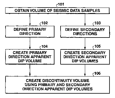
FIG. 1 is a flowchart illustrating the processing steps of an embodiment
of the method of the present invention;
CA 02414631 2002-12-23
WO 02/03099 PCT/USO1/20344
8
FIG. 2 is a flowchart illustrating the processing steps for creating an
apparenfidip volume in the method of the present invention;
FIG. 3 is a flowchart illustrating the processing steps for calculating
apparent dip in the method of the present invention;
s FIG. 4 is a view of adjacent seismic traces, illustrating the process of
constructing skeleton patches;
FIG. 5 is an example discontinuity time slice, processed using
discontinuity calculations alone; and
FIG. 6 is an example discontinuity time slice, processed using dip-
~o steered discontinuity calculations.
While the invention will be described in connection with its preferred
embodiments, it will be understood that the invention is not limited thereto.
On the contrary, it is intended to cover all alternatives, modifications and
equivalents that may be included within the scope of the invention, as defined
is by the appended claims.
DETAILED DESCRIPTION OF THE INVENTION
The present invention is a method of identifying structural and
2o stratigraphic discontinuities in a 3-D seismic data volume containing
dipping
reflectors. The invention is related to the method described in U.S.
Provisional Patent Application No. 60/197,587, filed April 17, 2000. That
application described a method for detecting structural and stratigraphic
discontinuities in a 3-D volume of seismic data samples (hereafter referred to
2s as the "discontinuity volume method"). One embodiment of the discontinuity
volume method comprises the following steps:
(1) A plurality of directions in the 3-D volume of seismic data samples are
selected in a sequential order.
(2) A series of sequentially less restrictive thresholds are defined.
30 (3) For each data sample in the 3-D volume, one-dimensional, two-trace
discontinuity values are calculated for the data sample sequentially
along the plurality of directions and the first of the calculated
CA 02414631 2002-12-23
WO 02/03099 PCT/USO1/20344
9
discontinuity values that satisfies the first threshold is stored in the
output discontinuity volume.
(4) For data sample locations that did not receive a discontinuity value
from step (3), the next less restrictive threshold in the series of
s thresholds is selected and are compared sequentially to the calculated
discontinuity values and the first of the discontinuity values that
satisfies the selected threshold is stored in the output discontinuity
volume.
(5) Step (4) is repeated, using progressively less restrictive thresholds,
to until every data sample location in the output discontinuity volume has
a corresponding discontinuity value.
A further embodiment of the discontinuity volume method of the
previous application comprises the following steps:
(1) A plurality of directions are selected containing a primary direction and
is at least one secondary direction.
(2) For each seismic data sample in the 3-D data volume, one-
dimensional, two-trace first discontinuity values are calculated along
the primary direction.
(3) A series of sequentially less restrictive thresholds is defined, such that
2o a significant portion, preferably at least approximately 10%, of the first
discontinuity values satisfy the first threshold.
(4) This significant portion of first discontinuity values is then stored in
an
output discontinuity volume at the corresponding sample locations.
(5) For each remaining data sample in the data volume, one-dimensional,
2s two-trace discontinuity values are calculated sequentially along the
secondary directions and the first of the calculated discontinuity values
that satisfies the first threshold is stored in the output volume.
(6) If none of the calculated discontinuity values satisfies the first
threshold, then the next less restrictive threshold in the series of
3o thresholds is selected and compared sequentially to the discontinuity
values calculated along the primary and secondary directions and the
CA 02414631 2002-12-23
WO 02/03099 PCT/USO1/20344
first of the discontinuity values that satisfies the selected threshold is
stored in the output discontinuity volume.
(7) Step (6) is repeated, using progressively less restrictive thresholds,
until every data sample location in the output discontinuity volume has
s a corresponding discontinuity value.
The present invention is a method of identifying structural and
stratigraphic discontinuities in a 3-D seismic data volume containing dipping
reflectors. In the method of the present invention, discontinuity
identification
is improved by following the framework of seismic sequence stratigraphy.
to Once the seismic horizons are determined, the trend of the detected
horizons
can thus be used as a regional trend to guide the correlation of the nearby
seismic samples. True structural and stratigraphic features such as faults and
channels can then be sharply focused. Thus, the discontinuity of the seismic
reflectors in the adjacent traces can be more accurately calculated without
is being confused by the apparent dip of the seismic reflectors. In the
present
invention, a modified version of the seismic skeletonization procedure is used
to create dip volumes in specified search directions. For a specified primary
or secondary search direction, each sample in a dip volume represents a shift
up or down in the vertical direction to locate the corresponding sample in an
2o adjacent trace along the specified search direction, to be used in the
discontinuity calculation.
FIG. 1 is a flowchart illustrating the processing steps of one
embodiment of the method of the present invention. First, at step 101, a
volume of seismic data samples is obtained. Any type of seismic data may be
2s used, but, preferably, the data will be seismic amplitude data in the form
of
fully processed seismic traces. Other appropriate types of seismic data
include, but are not limited to, impedance data, curvature data, and prestack
seismic data. Noise in the seismic data can effect the results of the method
of
the present invention. A median filter, preferably a 3x3 median filter, is
3o usually applied to the volume of seismic data to minimize the effects of
noise.
The median filter is not required, but significantly improves the final
results in
almost all cases.
CA 02414631 2002-12-23
WO 02/03099 PCT/USO1/20344
11
Second, at steps 102 and 103, a plurality of directions containing a
primary direction and at least one secondary direction are defined in
sequential order for the volume of seismic data samples from step 101. Since
the seismic traces that contain the seismic data samples are usually situated
s in the vertical direction, the primary and secondary directions are
typically
chosen to be horizontal or parallel to the trend of the main formations in the
seismic data. In a preferred embodiment, two directions are defined and the
primary and secondary directions are labeled as the first and second
directions, respectively. Preferably, the first and second directions are the
to orthogonal x and y directions, respectively, of the Cartesian coordinate
system in which the seismic data are described. Alternatively, the first and
second directions are the in-line and cross-line directions of the seismic
survey used to collect the seismic data, which may differ from the x and y
directions described above. In an alternative embodiment, four directions are
is defined. A primary direction is selected from among these four directions
and
is designated as the first direction. The remaining three directions are
labeled
as the second, third, and fourth directions, respectively. Preferably, these
four
directions comprise the in-line, cross-line and two diagonal directions. The
primary and secondary directions are the directions in which both apparent
2o dip and discontinuity values will be calculated.
At steps 104 and 105, apparent dip volumes are created for the
primary direction and the secondary directions, respectively, as the search
directions. A modified procedure of seismic skeletonization is used to find
groups of connected seismic samples representing seismic horizons in each
2s direction. These groups are called skeleton patches. The skeletonization of
seismic reflectors consists of identifying the reflectors and then
representing
those reflectors by line segments. An iterative procedure of seismic
skeletonization is performed. At the first iteration, strong reflectors are
chosen
and connected first in skeleton patches. In subsequent iterations, the weaker
so reflectors are chosen to extend the connections. At each iteration, the
criterion to connect samples in the neighboring traces is based on the
similarity measurement of attributes of reflectors, preferably amplitude.
CA 02414631 2002-12-23
WO 02/03099 PCT/USO1/20344
12
Alternatively, other attributes that could be used include, but are not
restricted
to, frequency, duration, and shape of the reflectors. In the created dip
volumes, the samples located in skeleton patches on the detected seismic
horizons are filled with an apparent dip value. The apparent dip value
s represents the up or down shift from the current sample to the connected
samples in the adjacent trace along the primary or secondary direction being
currently searched. After all the data samples lying on the detected seismic
horizons have apparent dip values calculated, a filter is applied to the dip
volume to remove the extreme values and fill in values at the samples not in
to the detected seismic horizons. In this approach, the regional dipping
trends
are captured at each sample based on the detected seismic horizons. The
modified skeletonization procedure and the apparent dip calculation are
described below in more detail in connection with FIGS. 2 and 3, respectively.
Finally, at step 106, a discontinuity volume is created from one-
is dimensional, two-trace discontinuity values calculated at data sample
locations in the primary and secondary directions. The discontinuity value
calculations use the apparent dip values from the filtered primary and
secondary direction dip volumes calculated in steps 104 and 105 to insure
that the appropriate portions of adjacent traces are being cross-correlated.
To
2o calculate a discontinuity value in the primary direction, the dip value for
a
target data sample location is retrieved from the primary direction dip
volume.
The discontinuity calculation is then made between the target data sample
and the data sample location that is above or below the target data sample
location by the apparent dip value specified by the primary direction dip
2s volume. Similarly, the same discontinuity calculation is applied to the
secondary directions using the apparent dip values in the secondary direction
dip volumes.
Any suitable method may be used to calculate the discontinuity volume
of step 106. However, preferably, this discontinuity volume is calculated by
3o the method described in co-owned U.S. provisional patent application with
serial number 60/197,587, described above. Thus, one-dimensional, two-
trace first discontinuity values are calculated along the primary direction
for
CA 02414631 2002-12-23
WO 02/03099 PCT/USO1/20344
13
each seismic data sample in the 3-D data volume. These discontinuity values
are calculated using the apparent dip values from the corresponding sample
locations in the primary direction dip volume. Next, a series of sequentially
less restrictive thresholds is defined, such that a significant portion,
preferably
s at least approximately 10%, of the first discontinuity values satisfy the
first
threshold. This significant portion of first discontinuity values is then
stored in
an output discontinuity volume at the corresponding sample locations. The
following steps are then repeated for each remaining data sample until that
sample has a value stored at the corresponding sample location in the output
io discontinuity volume. One-dimensional, two-trace discontinuity values are
calculated for the sample sequentially along the secondary directions and the
first of the calculated discontinuity values that satisfies the first
threshold is
stored in the output volume. Again, these discontinuity values are calculated
using the apparent dip values from the corresponding sample locations in the
is appropriate secondary direction dip volumes. If, none of the calculated
discontinuity values satisfies the first threshold, then the next less
restrictive
threshold in the series of thresholds is selected. The discontinuity values
calculated along the primary and secondary directions are compared
sequentially to the selected threshold and the first of the discontinuity
values
2o that satisfies the selected threshold is stored in the output discontinuity
volume. This process is repeated until a discontinuity value has been stored
in each sample location in the output discontinuity volume. The discontinuity
value method does not calculate discontinuities at all sample locations for
all
directions and does not combine calculated discontinuities from different
2s directions at sample locations. Thus, this method is not as computationally
intensive as many of the other methods described above.
FIG. 2 is a flowchart illustrating the processing steps for creating
apparent dip volumes, as in steps 104 and 105 of FIG. 1, using a modified
form of seismic skeletonization. The apparent dips will be determined along
30 one of the primary or secondary directions from steps 102 and 103 of FIG.
1,
depending upon which primary or secondary direction dip volume is being
created. First, at step 201, a series of successively less restrictive ranges
for
CA 02414631 2002-12-23
WO 02/03099 PCT/USO1/20344
14
seismic amplitudes is defined. These ranges will determine the size of peaks
or troughs in seismic traces that define a continuous seismic horizon. Peaks
and troughs are the positive and negative amplitude portions of the seismic
trace, respectively. Although the method of the present invention could be
s practiced with both peaks and troughs, it will be described in terms of
peaks.
Using a series of successively less restrictive ranges allows an iterative
process that starts with the best defined portions of seismic horizons and
uses
them to guide the selection of less well defined portions.
At step 202, a peak detection process is performed. In this process, for
to each seismic trace in the volume of seismic data samples, groups of
adjacent
samples with peaks satisfying the defined range of seismic amplitudes from
step 201 are detected. During peak detection, the peaks are listed for each
seismic trace and the peak attributes are recorded for later correlation use.
Some of the attributes used could be location of the peak, area of the peak,
is average amplitude of the peak, etc. At step 203, a peak correlation process
is
performed. This process uses the lists of peaks along each trace from step
202 to derive a set of reflectors that run across these traces. The
correlation
step is performed for each peak in a trace with peaks in the neighboring
traces based on a predefined similarity measurement based on the previously
2o recorded peak attributes. Peaks belonging to the same reflector are
considered in the same strata and labeled by the same number. In the case
of junctions, branches, or missing peaks occurring from one trace to the next
trace, the connection will terminate at this peak. This process is repeated
for
each trace in the 3-D volume of seismic data samples. The traces are
2s preferably scanned from one side of the volume to the opposite side of the
volume. Alternatively, the traces could be scanned outwards toward the
opposite sides of the volume, starting from the trace with the largest peak
amplitude.
At step 204, a line-fitting algorithm is performed. At each peak, a point
so representing the peak is recorded. Preferably, the location of the maximum
amplitude occurring is used. The representative points are connected by
straight-line segments. The connected peaks are thus represented by a set of
CA 02414631 2002-12-23
WO 02/03099 PCT/USO1/20344
line segments called a skeleton patch. Each line segment connects two
peaks and the two end points of the patch represent the terminations of the
connection. The number of connected line segments in a skeleton patch is
called the length of the skeleton patch. Thus, the whole 3-D volume is
s represented by a group of isolated individual skeleton patches.
FIG. 4 illustrates the previous steps in the process of constructing
skeleton patches. A series of adjacent vertical seismic traces arranged along
one search direction are indicated by 401. Two adjacent peaks, as detected
by step 203 of FIG. 2, are indicated by 402. The points representing two
to adjacent peaks, as recorded in step 205 of FIG.2, are indicated by 403.
Straight-line segments connecting the representative points, as found by the
line-fitting algorithm of step 205 of FIG. 2, are indicated by 404. These fine
segments will define the skeleton patches. A missing peak, as detected by
the peak correlation process of step 204 of FIG. 2, is indicated by 405.
is Returning to FIG. 2, steps 202 to 205 will be repeated for each of the
successively less restricted ranges of seismic amplitude from step 201. Since
a less restricted condition will include more peaks in steps 202 and 203,
previously terminated skeleton patches can be extended. More low amplitude
and continuous reflectors can thus be included in the skeleton patches. Thus,
2o in step 206, it is determined if any seismic amplitude ranges from step 201
remain. If ranges remain, then the process returns to step 202 to iterate
steps
202 to 205 with the next less restrictive range of seismic amplitudes in the
series. If no ranges remain, then the process continues on to step 207.
In step 207, small skeleton patches with length less than a threshold
2s value, which can be user-specified or set automatically, are deleted to
reduce
noise. In step 208, apparent dip is calculated for each sample location if
this
sample is located in one of the skeleton patches. The dip is determined by
the vertical shift from this sample location to the location of a connected
end
point of a line segment to a correlated peak in the next trace, following
along
3o the primary or secondary direction of the dip volume being created. Only a
sample that has a connection in the current direction being searched will be
CA 02414631 2002-12-23
WO 02/03099 PCT/USO1/20344
16
recorded. This process of calculating apparent dip is described in more detail
in the discussion of FIG. 3, below.
In step 209, a filter is applied to the dip volume created from step 201
to 208 to fill in values for data sample locations in the dip volume that do
not
s originally have an identified connected group. The filter places a value in
empty data sample locations that is preferably calculated as a median or
average of values in nearby filled data sample locations. Once all data
sample locations are filled, the filtered dip volumes are complete.
FIG. 3 is a flowchart illustrating the processing steps for calculating
to apparent dip, as in, step 208 of FIG. 2. The apparent dip will be
determined
along one of the primary or secondary directions from steps 102 and 103 of
FIG. 1, depending upon which primary or secondary direction dip volume the
apparent dip is being calculated for. In step 301, a target data sample is
located that is in a skeleton patch along the primary or secondary direction
is currently being searched. In step 302, a data sample is located in the same
skeleton patch in an adjacent seismic trace along the primary or secondary
direction currently being searched. In step 303, the vertical shift in number
of
data samples between the selected and located data samples is determined.
This vertical shift is determined by counting the number of data samples up or
2o down between the selected and located data sample locations. In step 304,
apparent dip is then defined as the vertical shift in data samples between the
selected and located data sample locations. In this manner, apparent dip is
calculated in both the primary and secondary directions to create primary and
secondary direction apparent dip volumes, respectively.
2s Although the invention uses the seismic skeletonization process as the
preferred way to derive dip volumes, the dip-steered discontinuity process
described in this invention is not limited thereto. On the contrary, it is
intended to cover other alternate ways of deriving the dip volumes.
3o Example
CA 02414631 2002-12-23
WO 02/03099 PCT/USO1/20344
17
FIGS. 5 and 6 show discontinuity time slices from a field in south
Texas, processed using discontinuity calculations alone and dip-steered
discontinuity calculations, respectively. The NE-SW trending zone between
the two arrows comprises steeply-dipping fault blocks, separated by a
s complex network of faults. This is the crest of the anticline that defines
the
productive field. The dip-steered discontinuity volume illustrated in FIG. 6
provides much clearer images of the faults because the apparent discontinuity
created by steep dips has been removed.
It should be understood that the invention is not to be unduly limited to
to the foregoing which has been set forth for illustrative purposes. Various
modifications and alternatives wil! be apparent to those skilled in the art
without departing from the true scope of the invention, as defined in the
following claims.