Note: Descriptions are shown in the official language in which they were submitted.
CA 02429176 2003-06-05
WO 02/30131 PCT/CA01/01404
COMBINED COLOUR 2D/3D IMAGING
FIELD OF THE INVENTION
This invention relates to the fields of photogrammetry and remote
sensing, and in particular to stereoscopic imaging.
DISCUSSION OF THE PRIOR ART
Stereoscopic (3D) imaging is well known. Several methods are used to
form a 3D image using two complementary two dimensional (2D) colour or
black and white images of the same object or objects taken from two different
viewing locations. In one method, the two images are spaced a certain
distance apart and brought to a~particular focal distance to enable a
stereoscopic effect in the "overlap area" to be obtained. A stereo viewer is
used to properly position the stereo pairs but the image pair, however, is not
overlain.
Stereo images can also be generated using (1) Digital Elevation Model
(DEM)-based 3D and (2) Ariaglyph 3D technologies. With DEM-based 3D,
there is no 2D image effect and measurements cannot be made in 2D. With
Anaglyph 3D, a conventional black and white stereo image pair is overlain on
a printed medium or displayed on a computer monitor. A print screen of an
anaglyph displayed on a computer monitor is shown in Figure 1. The
anaglyph has been generated using an airborne frame sensor with a
"conventional viewing angle". The stereoscopic effect in the anaglyph can be
observed via a computer monitor or printed on a piece of paper when
stereoscopic filters axe used. While the 3D image is clear when viewed
CA 02429176 2003-06-05
WO 02/30131 PCT/CA01/01404
through filters, the 2D image viewed without filters is blurred. Image
measurements cannot be made on the 2D image. The blurred nature of the 2D
image has not been of concern in the past because photogrammetric
measurements using anaglyphs have hitherto been made using only the 3D
image. The blurring of the 2D image is caused by the nature of conventional
spaceborne/ airborne based imaging.
A colour 3D image can be produced on a computer monitor by
overlaying two colour images using conventional software such as is available
from PCI ERDAS, or other photogramrnetric software. The resulting image,
however, contains six colour bands (three from each colour image) and must
be polarized and viewed with expensive polarization filters in order to see a
3D effect. The image viewed without the filters is blurred. Furthermore, the
total data size of the overlaid image is the size of the two colour images.
The
3D image cannot be viewed when they printed on a piece of paper.
Conventional spaceborne/airborne based photogramrnetric stereo
imaging (including when a frame sensor or linear sensor is used) uses a large
viewing angle (20 - 30 degrees or more) for individual objects to ensure the
accurate measure the parallaxes on a stereo image pair and to generate a
DEM. Such large viewing angles, however, blur the 2D image when the
images are overlain using conventional methods to produce a 3D image.
Conventional non-photogramrnetric carnera/video imaging can also be
used to produce a 3D image. Such imaging usually has a short object
2
CA 02429176 2003-06-05
WO 02/30131 PCT/CA01/01404
distance, with an object depth that is very large. The ratio of object depth
to
object distance (depth/distance ratio) in such cases can be greater than 1:2.
The greater the depth/ distance ratio for a set of stereo image pairs, the
larger
the parallax, even when the viewing angle happens to be small. When
parallax is easily seen on a 2D image produced from a stereo pair, it will
appear blurred.
A conventional non-photogrammetric camera/video based system for
creating 3D images is disclosed in United States Patent No. 4,134,644 issued
to
Marks et al. on January 16,1979. In Marks, the same object is pictured from
two different viewing angles and the 3D colour effect is perceived using a
pair
of complementary colour glasses. When a frame camera or video recorder is
used as disclosed in Marks, the scale of the tilted image is not constant and
thus the parallaxes of the object on the two sides of the image are enlarged.
Consequently, when the image in Marks is viewed without the
complementary glasses, objects on the 2D image varying greatly in depth will
appear blurred.
It would be desirable to have a combined 2D/3D image product and
method which permits substantially clear viewing in both 2D and 3D.
GENERAL DESCRIPTION OF THE INVENTION
The object of the present invention is to meet the above-identified need
by providing a relatively simple image product which can be viewed in 2D
without stereo viewers and in 3D with stereo viewers. The 2D image looks
like a normal 2D image when viewed without stereo glasses, and the 3D
3
CA 02429176 2003-06-05
WO 02/30131 PCT/CA01/01404
image can be perceived when viewed with a pair of complementary stereo
glasses.
Accordingly, the invention relates to a combined colour 2D/3D image
which includes an image medium, a first image of an object including a first
colour band on said medium, a second image of said object including second
and third colour bands spaced first colour band overlaid on said second and
third eolour bands and in registration therewith sufficient to achieve
parallax,
whereby the combined image appears as a substantially clear 2D image when
viewed without a complementary colour filter and as a 3D image when
viewed with such a filter.
In another embodiment, the invention relates to a method for forming
a combined 2D/3D colour image of an object including the steps of producing
a first image of said object from a first viewing angle using a firs colour
band;
producing a second image of said object from a second viewing angle using
second and third colour bands; overlaying and registering said first and
second images on a medium, being such that the colour image appears as a
substantially clear 2D image when viewed without a complementary filter,
and as a 3D image when viewed with such a filter.
In a further embodiment, the present invention relates to a method of
collecting a ground image pair using an airborne or spaceborne sensor
including the steps of: producing a first image of the ground from a first
viewing angle, producing a second image of the ground from a second
4
CA 02429176 2003-06-05
WO 02/30131 PCT/CA01/01404
viewing angle, wherein the angular difference between said viewing angles is
between 0 and 5 degrees.
BRIEF DESCRIPTION OF THE DRAWINGS
The invention is described below in greater detail with reference to the
accompanying drawings, which illustrate preferred embodiments of the
present invention, and wherein:
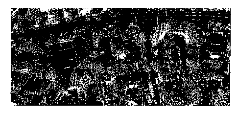
Figure 1 is a 2D representation of an anaglyph generated using a black
and white stereo image pair collected with an airborne frame sensor using a
conventional viewing angle;
Figure 2 is a black and white reproduction of a combined colour
2D/3D image according to the present invention;
Figures 3a and 3b are diagrams showing image recording with a linear
sensor according to the present invention;
Figure 4 is a diagram showing the principle of overlaying multispectral
bands and viewing 2D and 3D images according to the present invention;
Figure 5a is a diagram showing image generation using a frame sensor
according to the present invention;
Figure 5b is a diagram showing the relationship between airbase B and
overlay percentage OP according to the present invention;
Figure 5c is a diagram showing stereo pairs taken along the flying track
according tot he present invention; and
Figure 5d is a diagram showing a stereo pair taken across the flying
track according to the present invention.
CA 02429176 2003-06-05
WO 02/30131 PCT/CA01/01404
DETAILED DESCRIPTTON OF THE PREFERRED EMBODIMENT
In the preferred embodiment, the composite 2D/3D image contains
both colour 2D information and colour 3D information. Referring to Figure 2,
the combined image can be used as a normal 2D colour image map for image
measurements and the same image can also be used as a 3D colour image to
see colour 3D information when a pair of inexpensive complementary colour
stereo glasses are used. This image can be displayed on a computer monitor,
saved as a digital file, transferred via the Internet, and printed on a piece
of
paper. The data size of the 2D/3D colour image is equivalent to a normal 2D
colour image. For routine production, near-real-time 2D/3D images can be
generated at a very low price similar to that of a normal ZD colour image.
In the preferred embodiment of the invention, ground images are
obtained using satellite based conventional linear charge-coupled-device
(CCD) sensors. Because of the small depth/distance ratio for satellite
imaging, it is possible to adjust the viewing angle according to the present
invention to produce a multispectral image with both a substantially clear
colour 2D and 3D image.
Referring to Figure 3a, the collection of a stereo pair using a linear CCD
sensor includes first collecting a nadir image (the optical axis perpendicular
to
the ground). The objects on the ground, A, B, C, D and E, are imaged as a, b,
c, d and a on the nadir image generally indicated at 2. The sensor then turns
backwards slightly and images the same ground objects A, B, C, D and E as a ,
b', c', d' and e' on the corresponding tilted image generally indicated at 4
of
6
CA 02429176 2003-06-05
WO 02/30131 PCT/CA01/01404
the pair. Note that the object E is located on the ground at the same place as
C, but is not imaged at the same position on each image of the corresponding
image pair.
The tilted image can also be collected before taking the nadir images by
tilting the sensor slightly forwardly. The selection between forward imaging
and backward imaging is dependent on the direction of the sunlight
incidence. For example, when the areas to be imaged are located in the
northern part of the Earth, backward imaging is preferred as the
corresponding image pair for most high-resolution satellites. This is because
backward imaging can, in most cases, take images on the sunny side of
objects.
It will be understood that the stereo images can also be generated by a
slightly forward tilted and backward tilted image pair. However, the
advantage of using a nadir image as one image of an image pair is that a 2D
image generated from the image pair will have the ortho-image effect. This is
important for image mapping purposes. On the other hand, the nadir image
can also be used for other purposes such as where a 2D vertical photo or
ortho-photo is desired.
In the preferred embodiment, a combined 2D/3D colour image
according to the invention can be produced when the following conditions are
met:
(1) the image is composed of blue, green and red colour bands (for
displaying colour information);
7
CA 02429176 2003-06-05
WO 02/30131 PCT/CA01/01404
(2) the three bands are collected from two different viewing angles, one
band from one angle and two bands from another angle (for obtaining
colour stereo information). A colour 3D image can also be generated
when the three bands are collected from three different viewing angles.
However, the 2D and 3D colour effect will be not as clear as that from
two viewing angles; and
(3) the parallaxes of the majority of the objects in the image created by the
two viewing angles are minimized, such that the parallax is not easily
seen in the 2D colour image and the 3D effect can still be perceived.
When the colour image is composed of green from one viewing angle
and blue and red from another viewing angle, a pair of green-magenta (or
red-cyan) complementary stereo glasses can be used to see the colour 3D
colour image. Some types of stereo glasses, such as red-cyan and red-green
glasses, have been produced for conventional monochrome 3D viewing and
can be used if a black and white image pair is used.
Referring to Figure 4, when a CCD nadir image 6 is taken with the red
band, and a backward image (or forward image) 8 is taken using the green
band and blue band separately. In Figure 4, the bands in images 6 and 8 are
shown separated for illustration purposes. A combined natural colour 2D/3D
image generally indicated at 10 is generated by overlaying and registering the
three bands according to features on the ground. The natural colour is
generated by the red, green, and blue bands. The 3D colour image generally
indicated at 12 can be perceived by using a pair of complementary filter
8
CA 02429176 2003-06-05
WO 02/30131 PCT/CA01/01404
glasses having red 14 and cyan (green + blue) 16 filters (complementary
colour filter). because of the parallax of the objects. The parallax of object
E.
imaged as a and e' on the nadir image 6 and backward image 8 respectively is
depicted as pe. A full colour 2D image 13 can be perceived without the
glasses.
Alternatively, the green band can be used as the nadir image and the
red band and blue band as the tilted image. To perceive the colour 3D effect,
green and magenta (red + blue) glasses are used. A combined colour 2D and
3D image can also be generated by using green and blue bands as the nadir
image and the red band as the tilted image, or using red and blue bands as the
nadir and green as tilted. Consequently, the colour combination of the
complementary filter to view the colour 3D image has to be changed
accordingly. The colour band combination may also be selected according to
the colour of the real objects in the scene, e.g. whether two bands from the
nadir or one band from the nadir, as well as which colour from nadir, and
which colour from the backward image.
A colour 3D image can generally be generated by using any
combination of red; green and blue bands, when the viewing angle between
the bands is as described below, and when a pair of complementary stereo
glasses is used, e.g. red-cyan for the combination of red band overlaid with
green and blue bands; green-magenta fox green band overlaid by red and blue
bands; or blue-yellow for blue band overlaid by red and green bands. One
pair of stereo glasses might have better 3D and colour effect than the other
9
CA 02429176 2003-06-05
WO 02/30131 PCT/CA01/01404
two depending on the colour composition of objects on the image. The
density of each filter or the intensity and saturation of each colour may also
influence the perception of 3D and colour effect.
The third (3) condition above, is important in causing the 3D image to
have the appearance of a 2D image. Because the human eye is very sensitive
to the perception of object depths through parallaxes, but not as sensitive to
small parallaxes in a 2D image, properly minimizing the parallaxes of the 2D
image can greatly improve the quality of the 2D image, without disturbing
the 3D perception. This makes it possible to generate a combined 2D and 3D
colour image.
The parallax is minimized by minimizing the viewing angle of the
stereo images depending on the object heights on the ground. The higher the
objects, the smaller the angle. Figure 2 is a black and white representation
of
a natural colour combined 2D and 3D image generated according to the
method of the present invention using an airborne linear CCD image pair
(Nadir image: green band; Tilted image: red band and blue band; Viewing
angle: 3.5 degrees). The colour 3D effect can be seen by using red-cyan and
green-magenta glasses.
When a linear sensor is used for the image collection, the image scale
for the whole tilted image stays constant. Tlus is essential for the
generation
of a combined 2D and 3D image as the parallax of the objects with the same
height can be kept unchanged over the whole image. Consequently, the
parallax on the 2D image can remain quite small over the whole image, such
CA 02429176 2003-06-05
WO 02/30131 PCT/CA01/01404
that the 2D image is not blurred by the parallaXes, and the colour 3D effect
can be clearly perceived.
North-oriented colour combined 2D/3D images can also be generated
in accordance with the invention. Since most earth observation satellites have
a high latitude orbit to offer the greatest coverage of the Earth's surface,
it is
difficult to generate a north-oriented stereo image using a pair of along-
track
stereo images (forward and/ or backward tilted images). However, because
of the very small ratio of field of view (FOV) to orbit height (H) for the
satellite imaging (For example, FOV/H « 1/100 assuming H=400-~OOkm
and FOV=10-60km), the scale of the image does not visibly change when the
linear sensor tilts slightly sideward. This enables the generation of a north
oriented colour 2D and 3D image by using the side looking image pair. A
north oriented stereo image is useful because it meets more of the criteria of
standard mapping.
Method for Production Using Linear Sensors
The use of commercial high-resolution satellite imagery for producing
combined 2D/3D colour images/image maps is preferred because:
(1) In commercial high-resolution satellites such as IICONOSTM,
OrbviewTM and QuickBirdTM, the viewing angle can be altered to point
to targets within ~45° about the nadir axis;
(2) Such satellites .deliver multi-spectral images in blue, green, red and
infrared spectral regions; and
11
CA 02429176 2003-06-05
WO 02/30131 PCT/CA01/01404
(3) The imagery is collected by a CCD linear sensor. Such a sensor is
preferred because tilted images can be produced in which the image
scale is constant throughout the image. Maintaining the image scale
constant is important in the present invention so that the parallax of
objects with the same height can be kept unchanged over the whole
image. The use of a linear sensor also makes it possible to produce an
excellent colour 2D and 3D image mosaic by "sewing" together the
neighbouring stereo strips which contain the same band combination,
and in which the tilted images have the same viewing angle.
By imaging the same ground objects from two slightly different
viewing angles, (such as one nadir and one slightly backward), selecting an
appropriate angle difference between image pairs according to the invention,
and by selecting two colour bands from the nadir and the third band from the
backward angle, a combined 2D/3D colour image can be generated. , To get
an optimal 2D colour and 3D colour effect, the viewing angle difference may
be slightly adjusted depending on the building (or other object) heights or
the
relief height difference on the ground.
For normal images, such as those displayed on a standard computer
monitor, if the parallax of a building is smaller than 0.5mm on a combined
2D/3D image according to the present invention, the human eye will not
easily detect it when viewing the 2D image. Consequently,~the image has a
2D effect like a normal 2D image. Satellite images with a resolution of 1rn
are
suitable to produce image maps at the scale of 1:5,000. At this scale, a
parallax
12
CA 02429176 2003-06-05
WO 02/30131 PCT/CA01/01404
of 0.5mm is equivalent to 2.5 pixels on a computer monitor. If the stereo
image is displayed on a computer monitor (72 dpi), the human eye will not
easily detect parallaxes of less than 2 pixels. In the preferred embodiment, a
nadir image and a backward image are used. Referring to Figure 3b, the
relationship between viewing angle a (the backward angle), building height
(h) and parallax (p) can be described with the following formula:
tana,= p
h
When a parallax criterion of 2.5 pixels is used, the relationship between
viewing angle (a) and building height is as follows:
Building 10 20 30 40 50 60 70 80 90 100 110
height
(m) '
Viewing angle14 7.14.8 3.6 2.9 2.4 2.0 1.8 1.6 1.4 1.3
(deg)
For residential areas with mainly family houses, a viewing angle of
about 5 degrees is suggested. For city areas with mainly large buildings, a
viewing angle of 3 degrees is recommended. For high-rise building areas,
such as in the downtowns of North American cities, a viewing angle of 1.5
degrees is suggested. The suggested viewing angles are approximate values
calculated using the assumption that 1:5,000 stereo image maps are used.
Relationships between image scales and parallaxes
In addition to being dependent on the height of buildings in an image,
the ideal parallax dimension is also related to the nature of the terrain as
well
as the size and scale of the image. This relation is explained in Examples 1
13
CA 02429176 2003-06-05
WO 02/30131 PCT/CA01/01404
and 2. The "product examples" are examples of products in which the present
invention could be used.
Example 1.
Generation of urban 2D/3D colour images using remote sensing imagery
with a resolution between 0.2 and 2.0 m:
Image scaleIdeal parallaxproduct example
size
1:10,000 0.05 - 0.5 ocket book
mm
1:5,000 0.1-1.0 mm image maps, video
screen, computer screen,
ma azine
1:2,500 0.2 - 2.0 mm wall poster
The parallax size is in direct proportion to the image scale. For different
display purposes, the image scale can be changed. Consequently, the parallax
size should also be changed. For example, if the scale is enlarged by
multiplying a number of two (scale x 2), the parallax size should also be
multiplied by two (parallax size x 2). And vice versa.
Example 2.
Generation of mountainous 2D/3D colour images using remote sensing
imagery with a resolution between 5 and 20 m:
Image scaleIdeal parallaxproduct example
size
1:100,000 0.05 - 0.5 ocket book
mm
1:50,000 0.1-1.0 mm image maps, video
screen, computer screen,
ma azine
1:25,000 0.2 - 2.0 mm wall oster
The parallax size is in direct proportion to the scale. For different
display purposes, the image scale can be changed. The relationship between
parallax size and scale is the same as in Example 1.
14
CA 02429176 2003-06-05
WO 02/30131 PCT/CA01/01404
By using remote sensing imagery with a resolution between 2 and 5 m,
the suitable scale of a 2D/3D colour image for a desk publication is around
1:15,000 and the parallax size is between 0.1 and 1.0 mm. For different
display puxposes, the image scale can be changed; however, the parallax size
should also be changed in direct proportion to the scale and the viewing
distance. It is understood, however, that the parallax size cannot be zero
because without parallax a 3D effect cannot be seen.
By using imagery with a resolution of around 50 m, the suitable scale
of a 2D/3D colour image for a desk publication is around 1:250,000 and the
parallax size is between 0.1 and 1~.0 mm.
Method of Production using; frame sensors
Frame sensors can also be used to produce combined 2D/3D images.
One photo 18 is taken with two colour bands from a first exposure position
and another photo 20 is taken with another colour band at a second slightly
different exposure position (see Figure 5a). The two photos of a stereo pair
should be both vertical photos (optical axis perpendicular to the ground), so
that the scale difference in the overlapped area can be minimized. The
exposure stations of the two photos should be close to each other, so that the
angle between the two Iight rays from the two exposure stations to any object
in the overlapped area can be kept sufficient small. Because the
depth/distance ratio (the ratio of object depth to object distance) is
relatively
small for airborne or spaceborne images, the variance of the view angles
between different objects is small over the whole overlap area. These
CA 02429176 2003-06-05
WO 02/30131 PCT/CA01/01404
conditions result in small and substantially constant parallaxes throughout
the overlap area. Therefore, the 2D colour image is substantially clear to the
eye and a 3D effect can also be seen.
The optimal distance between the two exposure positions is influenced
by the flying height of the airplane, the object heights on the ground and the
focal length of the camera. However, if the parallaxes of most objects in the
image can be kept less than 1 mm in the overlapped area by adjusting the
exposure distances, a 2D and 3D colour image can be generated. Referring to
Figure 5b, by fixing the parallaxes p,.eilef to a value of less than or equal
to 1
mm in the image, the optimal exposure distance B (also called airbase) can be
calculated by using the following equation when the flying height H, focal
length f and the average height of most objects h in the photo area are known:
B - (H - h) x H x preuef
fxh
The following equation can be used to determine the optimal overlap
percentage (OP) of a stereo pair for generating combined 2D/3D colour
images when the size of the photo (c~-is also known:
OP -1 _ (H - h) prerref
100 dh
For example, suppose that the camera used for 2D/3D imaging has a
focal length of 152 rnm and a photo size of 32 cm x 32 cm, and suppose that
the flying height is 1,000 m and the average building heights is 30 m on the
ground. Then, the optimal overlap percentage (OP) for 2D/3D imaging (prelief
16
CA 02429176 2003-06-05
WO 02/30131 PCT/CA01/01404
<_ 1 mm) should be equal to or less than 89%. (e.g, if f =152 mm, d = 320 mm,
H =1,000 m, h = 30 m, and p,~ehef<_ 1 mm, then OP <_ 89%).
The relationship between airbase B and overlap percentage OP can be
seen in Figure 15b. The stereo pair 22,24 (taken with green, and red and blue
bands respectively), can be taken along the flying track 26 (see Figure 5c) or
across the flying track 28 (see Figure 5d).
However, using a frame sensor, 2D and 3D colour mosaics cannot be
generated because the 3D image on the left part of the mosaicing boundary is
from the left photo pair, that on the right part from right pair, and there is
no
good stereo effect in the middle.
Method for Combining 2D/3D colour images
Once the required colour image bands are obtained, the generation of
the 2D/3D colour images can be performed using many commercial software
tools such as PCI and ERDAS - the most widely used remote sensing. and
image processing software products. Using image registration tools of the
software products, such as GCP Works of PCI or other geometric correction
tools, the image bands acquired from two different viewing angles can be
registered to a same datum. It is important to just register the corresponding
features on the ground, but not on the top of an object in order to preserve
3D
effect.
If it is found that when an image pair is registered using corresponding
features on the ground, the resulting parallax at the top of tall objects is
perceptible when the ZD image is viewed, the position of one image from the
17
CA 02429176 2003-06-05
WO 02/30131 PCT/CA01/01404
registered image pair can be moved slightly (e.g., 1 to 5 pixels depending
upon image scale) along the parallax direction to reduce the absolute parallax
sizes of some high objects. By doing this, parallaxes will be introduced into
objects on the ground in an opposite direction. However, the overall absolute
parallaxes throughout the ZD/3D image will be reduced, so that the 2D colour
image will appear clearer. This image shift does not reduce the 3D colour
effect. Commercial software such as PhotoShop and Corel Photo Paint
contain the functions to shift individual bands within one colour image.
Modern remote sensing systems, such IKONOS, may provide image
bands that have been registered. For such images, the image registration step
may be omitted.
Method of Production Using; Image Fusion Methods
The present invention can also be used to generate colour 2D and 3D
images using high resolution satellite and airborne CCD imagery. The
commercial high resolution satellite sensors can collect stereo image pairs at
viewing angles according to the invention. Multispectral image bands (blue,
green, red and near infrared) with a 4m resolution and panchromatic band
with a 1m resolution are available from such satellites. Commercially
available image fusion methods can fuse the multispectral and the
panchromatic images to produce pan-sharpened (1-m) multispectral images.
These pan-sharpened images can be used to generate high-resolution (1m)
2D/3D colour images.
1~
CA 02429176 2003-06-05
WO 02/30131 PCT/CA01/01404
The available image,fusion methods are, for example: the SVR
(Synthetic Variable Ratio), IHS (Intensity, Hue, Saturation) and PCA
(Principal Component Analysis) techniques. The SVR method reproduces the
colour of the multispectral image better than the widely used HIS and PCA
techniques (Zhang, Yun 1999: A.New Method for Merging Multispectral and
Multiresolution Satellite Data and Its Spectral and Spatial Effects.
International Journal of Remote Sensing, Vol. 20, No.10, pp. 2003-2014). The
spatial effect of the SVR technique is as good as the two conventional
techniques.
Further Advantages
The present invention permits the appearance of a 2D colour image
and a 3D colour image of the same objects on one piece of paper or on one
computer screen, or simultaneously on another medium such as a piece of
cloth or a mouse pad. The invention adds a totally new function to image
maps, i.e. one image map can be used for both 2D measuring and colour 3D
viewing at the same time. The stereo glasses for colour 3D viewing are
inexpensive. Therefore, the 2D/3D colour images/image maps have wide
application potential in areas where image maps are demanded (particularly
in urban areas) and in the fields of regional planning, real estate, tourism,
entertainment, agriculture, forestxy, military intelligence, etc. The
potential
applications arising from the use of commercial high-resolution satellite
imagery to generate the 2D/3D colour images/image maps axe especially
numerous because the high-resolution imagery is available world-wide and
19
CA 02429176 2003-06-05
WO 02/30131 PCT/CA01/01404
the 2D/3D colour images/image maps can be produced for every area in the
world.
The invention can also be used to produce some types of 3D digital
games. For example, if the invention is applied to a conventional 2D maze
game, the game can still be played as a 2D game without using a pair of stereo
glasses. However, when the player sees the image through a pair of stereo
glasses, he/she will see a colour 3D game. This makes the game more vivid
and interesting.