Note: Descriptions are shown in the official language in which they were submitted.
CA 02431686 2003-06-16
WO 02/054110 PCT/GBO1/05684
1
Subsea Navigation and Survey
This invention relates to subsea navigation, for example following or tracking
of subsea structures to facilitate inspection or other operations, it further
relates
to surveying the position of subsea structures.
Performing periodic inspection and/or maintenance is essential in the
operation
of subsea pipeline systems. There are two main ways in which this is currently
conducted, i.e. by the use autonomous underwater vehicles (AUVs) or directly
by divers.
The use of AUV's is preferred but problems still arise. For example, when
carrying out an inspection, the AUV must be made to follow the appropriate
subsea structure closely enough so that it can provide useful information.
Typically, when inspections are being carried out, the AUV will include sonar
scanning equipment to form images of the structure. With such equipment
there is a trade off between resolution and field of view. Therefore, if the
precise position of the structure is not known relative to the AUV, the
equipment must be set up with a relatively large field of view and a
correspondingly low resolution to ensure an image of the structure is
obtained.
In most circumstances, it is either undesirable or impossible for a human
operator to monitor the position of an underwater vehicle relative to the
subsea
CA 02431686 2003-06-16
WO 02/054110 PCT/GBO1/05684
2
structure and hence AUV's are used which attempt to follow the structure
autonomously.
Existing systems use inertial navigation equipment which does not operate
perfectly. Thus the further an AUV is from its start point, the further off
course
it may have wandered. In practice this means that the array of sonar detectors
provided on the AUV has to be configured to give a field of view sufficient to
cope with the maximum deviation from course which might arise during the
length of the scan. As mentioned above this leads to a reduction in
resolution.
It is an object of a main aspect of this invention to provide a navigation
system
which allows navigation relative to a subsea structure.
It is an object of another aspect of this invention to provide a subsea survey
method.
According to a first aspect of the invention there is provided a method of
subsea navigation comprising the steps of:
causing a plurality of spaced antenna means provided on a subsea structure to
emit electromagnetic radiation; and
receiving and analysing said radiation at a subsea vehicle to allow the subsea
CA 02431686 2003-06-16
WO 02/054110 PCT/GBO1/05684
3
vehicle to navigate relative to the subsea structure.
According to a second aspect of the invention there is provided a subsea
navigation system comprising a plurality of spaced antenna means provided on
a subsea structure and arranged to emit electromagnetic radiation, and
detection
means provided on a subsea vehicle for receiving and analysing
electromagnetic radiation transmitted by the antenna means to allow a subsea
vehicle to navigate relative to the subsea structure.
According to a third aspect of the invention there is provided apparatus for a
subsea navigation system, the apparatus comprising a plurality of antenna
means arranged to be mounted in a spaced relation on a subsea structure for
emission of electromagnetic radiation, and detection means arranged for
location on a subsea vehicle for receiving and analysing electromagnetic
radiation transmitted by the antenna means to allow the subsea vehicle to
navigate relative to the subsea structure.
The term subsea is used in this application as this is conventional
terminology,
however it will be appreciated that the term subsea should be taken to include
any underwater situation.
CA 02431686 2003-06-16
WO 02/054110 PCT/GBO1/05684
4
In some cases a common signal generating means may be provided for driving
some or all of the antenna means. Preferably however, independent signal
generating means are provided for each antenna means. Said apparatus may
comprise signal generating means.
The system is typically arranged so that radiation from each antenna means can
be received mutually independently to reduce or eliminate interference or
confusion. This may be achieved in a number of different ways.
In some embodiments the radiation emitted by the individual antenna means is
not mutually identical. It is particularly preferred if the radiation emitted
by
one antenna means is detectably different from that emitted by each adjacent
antenna means. Using different frequencies is a preferred way to provide
detectably different radiation.
In some embodiments three detectably different instances, typically three
different frequencies, of radiation may be emitted.
The radiation may be emitted at differing times by each antenna means to aid
or allow discrimination.
CA 02431686 2003-06-16
WO 02/054110 PCT/GBO1/05684
The system, apparatus or method may be arranged so that the emission of
radiation from the antenna means is triggered by a signal issued from
transmission means on the subsea vehicle. Such triggering may be selective.
5 The receiving means and analysing means may be arranged to perform 3 axis
electric field detection. This allows the direction of a vector towards the
source
transmitting the radiation to be found.
The method, system and apparatus may be arranged to allow the subsea vehicle
to track the subsea structure.
This invention is particularly applicable where the structure to be tracked is
a
pipeline system. In such cases the subsea vehicle will normally be an
Autonomous Underwater Vehicle (AUV) which is being used to inspect or
otherwise interact with the pipeline system.
The method, system and apparatus may be arranged such that the underwater
vehicle is able to determine its position relative to the subsea. structure.
In some
circumstances this would enable the underwater vehicle to determine its
position absolutely relative to the Earth's surface. The analysing means may
be
arranged to determine the position of the underwater vehicle relative to the
CA 02431686 2003-06-16
WO 02/054110 PCT/GBO1/05684
6
subsea structure. This may be achieved using the results of 3 axis field
detection and triangulation techniques.
A pipeline system typically comprises metallic structure which is provided
with
cathodic protection anodes. In such cases, the plurality of antenna means of
the
present method, system and apparatus may comprise a plurality of anodes, each
anode acting as or as part of a respective antenna means. Anodes are located
at convenient spaced locations along the structure, can function well as
antennas, and, of course, are already present for other reasons. This makes
the
use of anodes in the antenna means particularly attractive.
The metallic structure of a pipeline system will generally comprise one or
more
flowline and possibly other structures such as manifolds, trees, and
wellheads.
According to another aspect of the present invention there is provided a
method
for surveying the position of a subsea structure comprising the steps of:
monitoring the position of a subsea vehicle relative to a known reference
point;
causing a plurality of spaced antenna means provided on the subsea structure
to
emit electromagnetic radiation;
causing the subsea vehicle to travel along the subsea structure; and
analysing said radiation as received at the subsea vehicle as it travels to
allow
CA 02431686 2003-06-16
WO 02/054110 PCT/GBO1/05684
7
the determination of the position of the subsea structure relative to the
subsea
vehicle and hence relative to said reference point.
Embodiments of the present invention will now be described, by way of
example only, with reference to the accompanying drawings in which:-
Figure 1 schematically shows part of a pipeline system and a nearby AUV;
Figure 2 schematically snows an anode and a section of flowline in the
pipeline
system of Figure 1; and
Figure 3 schematically shows a three axis electric field detecting means
provided at the AUV shown in Figure 1.
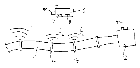
Figure 1 shows part of a pipeline system comprising a flowline 1 and a
wellhead 2 as well as a nearby AUV 3 which is being used to inspect the
pipeline system. The AUV 3 comprises appropriate sonar and/or other
scanning equipment SC to allow the inspection and recording of the condition
of the pipeline system.
The pipeline system is a metallic structure and is provided with a plurality
of
CA 02431686 2003-06-16
WO 02/054110 PCT/GBO1/05684
8
cathodic protection anodes 4 at spaced locations. Referring to Figure 2, each
anode 4 is connected to its respective portion of metallic structure 1, 2 via
inductance means 5. Further, a respective transmitting means 6 is connected
across each inductance means 5. The inductance means 5 is chosen to have
virtually zero impedance to the cathodic protection currents which must pass
through the anode, whilst having a high impedance to signals generated by the
respective transmitting means 6. In this way it is possible for each anode 4
to
act as an antenna when the transmitting means 6 is operated.
In operation, the metallic structure 1, 2 and earth, via the respective anode
4
and other remote earthing locations, act as a signal circuit. However, in the
present application all that is important is that it is possible for the anode
to
radiate electromagnetic waves away from it and hence away from the metallic
structure 1, 2.
The AUV 3 comprises detecting means 7 for receiving and analysing the
electric field caused by electromagnetic radiation emitted from the anodes 4.
The AUV 3 further comprises transmitting means $ arranged to transmit trigger
signals to receiving and control means 9 associated with each anode 4. Each
receiving and control means 9 is arranged to cause operation of the respective
CA 02431686 2003-06-16
WO 02/054110 PCT/GBO1/05684
9
transmitting means 6 upon receipt of an appropriate trigger signal from a
nearby AUV 3.
In operation, the AUV 3 begins its inspection journey at a point nearby the
pipeline system. The transmitting means 8 on the AUV 3 is caused to emit a
trigger signal which is received by the receiving and control means 9
associated with nearby anodes 4. On receipt of this trigger signal, each
receiving and control means 9 causes its respective transmitter means 6 to
operate and thus cause its respective anode 4 to emit electromagnetic
radiation.
It is important that the AUV 3 is able to receive signals from the individual
anodes independently. Thus, some means must be provided to allow the signals
to be distinguished. There are a number of ways in which this can be
accomplished as will be evident to those skilled in the art.
In the present embodiment, the transmitting means 6 do not all transmit at the
same frequency. In particular, three different frequencies f,, f z, f 3 are
used.
The transmitting means 6 are arranged so that each anode 4 emits radiation at
a
different frequency than its immediately adjacent neighbours.
The detecting means 7 in the AUV 3 receives and analyses the radiation
CA 02431686 2003-06-16
WO 02/054110 PCT/GBO1/05684
emitted from any nearby anodes 4 which are transmitting. The detecting means
7 comprises a three axis electric field detection means schematically shown in
Figure 3. The three axis detection means comprises a non-conductive frame 70
having three mutually perpendicular legs. A common electrode 71 is provided
5 at the joining point of the legs and respective other electrodes 72, 73, 74
are
provided at the end of each leg. A shielded conductor (not shown) is provided
from each electrode 71 - 74 to the remainder of the detecting means 7. In use
the relative potential between the common electrode 71 and each of the other
electrodes 72 - 73 is measured in turn. As the legs are mutually orthogonal
10 these measurements are representative of the x, y, z components of the
detected
field in the frame of reference determined by the legs and thus the direction
towards the transmitting anode can be determined. Preferably the 3 axis
detection means is allowed to float freely in the sea or is formed around the
AUV 3. In one particular arrangement the AUV 3 is housed in a carbon
fibre/kevlar cage and parts of the cage acts as the legs 70 between electrodes
71 - 74 provided on its corners.
The AUV 3 is arranged to use the determined directional information to control
the path of the AUV 3 ensuring that it closely tracks the pipeline system and
thus that the pipeline system remains within the field of view of the scanning
equipment SC.
CA 02431686 2003-06-16
WO 02/054110 PCT/GBO1/05684
11
In the present embodiment the instantaneous position of the AUV 3 relative to
the subsea structure is determined using standard trigonometric techniques.
Although this is not essential for simple tracking, it gives greater
flexibility in
general navigation. Thus the present system can be used for general navigation
purposes in the region of the structure.
The AUV 3 may have access to a map of the structure being followed or other
data which can be used in determining a new heading. Such information may
also be used to allow navigation relative to the Earth's surface when the
position of the structure is known.
At a straight section of a pipeline, information concerning the directions to
transmitting anodes may be insufficient to pinpoint the AUV 3 relative to the
pipeline 1. For this reason a gravity sensor or vertical gyro may be used to
provide additional information.
It is possible for the signals emitted by the anodes 4 to carry coded
information
which can be interpreted by the AUV 3. For example the coded information
may include a unique address or location information to enable the AUV 3 to
pinpoint its position along the pipeline structure. Other information, for
example sensor readings, may be coded onto the signals emitted by the anodes
CA 02431686 2003-06-16
WO 02/054110 PCT/GBO1/05684
12
4. This clearly facilitates the collection of data from components and sensors
associated with the subsea structure in addition to, or in alternative to,
data/images obtained from the scanning equipment provided on the AUV 3.
Although not described in detail it is also possible for the AUV 3 to send
signals to the pipeline l, these might then be transmitted along the pipeline
to a
remote location.
The present embodiment makes use of electric signals of frequency up to 10
KHZ. With such a system, the electric signals transmitted from the anodes 4
should have a range in the order of Iow hundreds of metres. In alternatives a
two tier frequency regime can be used. Since low frequencies will travel
further
in water, a lower frequency might be used as an AUV 3 homes in, and once
close to the pipeline a higher frequency could be used.
In some implementations, direct, and possibly real time, communication of the
data obtained and processed by the AUV 3 may be made to a surface vessel.
Such communication may be implemented in a number of different ways but
preferably the AUV 3 has a tetherless mode of operation so any
communication to the surface is preferably wireless.
CA 02431686 2003-06-16
WO 02/054110 PCT/GBO1/05684
13
It should be noted that this navigation system is not restricted to use with
AUVs inspecting pipeline systems. On the contrary, it may be used with any
subsea vehicle where there is a desire to navigate relative to a subsea
structure.
In a development of the above system the AUV 3 and transmitting anodes 4
may be used to "survey in" a pipeline 1. In this case the position of the
pipeline relative to the Earth's surface is unknown and is to be determined.
The
system described above is used to record the relative position of the pipeline
1
and the AUV 3 as the AUV 3 is moved along the pipeline 1. The position of
the AUV 3 as it moves relative to Earth is monitored using sonar and GPS for
example. The combination of knowing the "absolute" position of the AUV 3
and the position of the AUV 3 relative to the pipeline 1 enables the
"absolute"
position of the pipeline to be mapped.