Note: Descriptions are shown in the official language in which they were submitted.
CA 02437926 2003-08-20
1
MOBILE AD HOC NETWORK DEVICE FOR MOBILE TEAMS
FIELD OF THE INVENTION:
This invention relates to network device, and more particularly, to a mobile
ad
hoc network device for mobile teams.
BACKGROUND OF THE INVENTION:
Creating an air-to-air/air-to-ground wireless network for airborne fire
fighting
operations is a very new idea that has yet to be developE~d. Currently, all
fire fighting
coordination is handled through basic voice communications, which is error
prone,
often ambiguous, inaccurate, slow, and is less effective for coordinating
operations,
which causes many safety hazards and poor operational effectiveness.
~5 Ad hoc network has been developed. The ad hoc; network is described in
US2003/0060202, WO 03/03047, US2003/0091011. However, for applying the ad
hoc network to fire fighting services, further improvements are still needed,
since
those services require handling time-sensitive critical information for
coordinating
operations such as fire fighting.
2o It is therefore desirable to provide a new mobile ad hoc network device for
mobile teams, which ensures real-time, high speed and effective operations for
mobile teams, and allows the teams to coordinate their operations in real
time.
SUMMARY OF THE INVENTION:
It is an object of the invention to provide a novel method and system that
obviates or mitigates at least one of the disadvantages of existing systems.
In accordance with an aspect of the present invention, there is provided a
device for
3o ad hoc wireless network. The device includes: a module for establishing
wireless
connection with a positioning system to obtain location information; a module
for
CA 02437926 2003-08-20
2
performing communication with a node of the ad hoc wireless network using
radio
frequency, which is interchangeable, to share the information in the ad hoc
wireless
network in real time; a module for integrating multiplle information including
the
location information; and a module for self-forming and maintaining the ad hoc
wireless network.
In accordance with a further aspect of the present invention, there is
provided a
system for ad hoc wireless network. The system includes: a platform layer for
managing a peer network and managing information; a device layer for
performing
physical interface to incoming and outgoing information, which includes
wireless
radio frequency data and location information provided by a positioning
system, and
for providing the information to the platform layer; a core engine for
providing
communication between the platform layer and the device layer, which includes
a
routing engine for self-forming and self healing the ad hoc network, the
platform layer
15 being isolated from the core engine implementation; and an application
programming
interface for interfacing the platform layer and applications.
Other aspects and features of the present invention will be readily apparent
to those
skilled in the art from a review of the following detailed description of
preferred
2o embodiments in conjunction with the accompanying drawings.
BRIEF DESCRIPTION OF THE DRAWINGS:
The invention will be further understood from the following description with
25 reference to the drawings in which:
Figure 1 is a diagram showing a Mobile Ad Hoc Network with Multi-Hopping;
Figure 2 is a diagram showing an example of Traffic View provided by a Traffic
View User Interface in accordance with an embodiment of the present invention;
CA 02437926 2003-08-20
3
Figure 3 is a diagram showing an example of Operational View provided by an
operational User Interface in accordance with an Embodiment of the present
invention;
Figure 4 is a diagram showing the Operational View of Figure 3, which is
displayed with map;
Figure 5 is a diagram showing a final approach to cropping water or retardant
on a fire;
Figure 6 is a diagram showing a first example of Ilnstrument View provided by
an Instrument View User Interface in accordance with an embodiment of the
present
invention;
Figure 7 is a diagram showing a second example of the Instrument View of
Figure 6;
Figure 8 is a diagram showing a third example of the Instrument View of Figure
6;
~5 Figure 9 is a diagram showing an example of TE:xt View provided by a Text
View User Interface in accordance with an embodiment of the present invention
Figure 10 is a block diagram showing an Air Attack Network system in
accordance with an embodiment of the present invention;
Figure 11 is a diagram showing an Application plal:form, an Application and
the
2o core of Figure 10;
Figure 12 is a diagram showing an example of the operation of a Routing
Engine shown in Figure 10;
Figure 13 is a diagram showing the operation of the Routing Engine of Figure
12 for broadcasting Hello Messages;
25 Figure 14 is a diagram showing the operation of the Routing Engine of
Figure
12 for processing Hello Message;
Figure 15 is a diagram showing the operation of the Routing Engine of Figure
12 for route discovery;
Figure 16 is a diagram showing the operation of the Routing Engine of Figure
30 12 for processing Route Request;
CA 02437926 2003-08-20
4
Figure 17 is a diagram showing the operation of the Routing Engine of Figure
12 for processing Route Reply;
Figure 18 is a diagram showing the operation of the Routing Engine of Figure
12 for processing Route Error Message;
Figure 19 is a diagram showing the operation of the Routing Engine of Figure
12 for repairing Broken Route;
Figure 20 is a diagram showing an example of the operation of a Network
Wrapper shown in Figure 10;
Figure 21 is a diagram showing an example of the operation of a Network
Manager shown in Figure 10;
Figure 22 is a diagram showing an example of the operation of a Transport
Wrapper shown in Figure 10;
Figure 23 is a diagram showing an example of thE~ operation of a GSP support
shown in Figure 10;
~5 Figure 24 is a diagram showing an example of th~~ operation of GPS services
shown in Figure 10;
Figure 25 is a diagram showing the operation for Forestry Fire Fighting
provided by the 9GAAN system 100 of Figure 10;
Figure 26 is a diagram showing the operation of Common GUI Operations of
2o Figure 25;
Figure 27 is a diagram showing the operation of a Fire Fighting Engine of
Figure 25;
Figure 28 is a diagram showing the operation of an Operational View of Figure
25;
25 Figure 29 is a diagram showing the operation of a Traffic View of Figure
25.
Figure 30 is a diagram showing the terminal device architecture;
Figure 31 is a diagram showing relative Doppler shifts of three nodes.
DETAILED DESCRIPTION OF THE PREFERRED EMBODIMENTS:
An Air Attack Network in accordance with an embodiment of the present
invention
CA 02437926 2003-08-20
(referred to as 9GAAN) is a system and a method for as:>isting air and ground
crew in
remote forest fire fighting which uses radio frequency wlireless data
connections in a
remote self-forming mobile ad hoc data network which does not require the
existence
of an access point in order to create a complete data network. The terminal
device
5 contains a processor, a radio frequency data transceiver device, a location
device, a
physical screen for data output, the fire fighting Application or other
application
software and 9GAAN platform software, and the core engine. Figure 30 shows the
main components of the terminal device.
Data input is accepted from multiple sources including but not limited to
discovery
messages, direct connection and connectionless data between devices,
positional
information such as Global Positioning System (GPS) satellite data or the
like, aircraft
transponder data or other data such as satellite-derived data, such as weather
conditions or the like. Data output includes multiple logical screens
including but not
limited to the "Traffic view", the "Operational view", and the "Instrument
View" as
~ 5 described below.
The "Traffic view" shows the location, altitude, velocity and identity of
other aerial or
ground units.
2o The "Operational view" shows critical operational data including but not
limited to
location and status of the fires, location, water status, direction and speed
of aircraft
and ground units, and assigned drop locations for aircraft. It permits the
interactive
user input of instructions and other data through stylus, keyboard, voice, or
other
means.
The "Instrument View" shows relative bearing, distance, and time to the fire
drop
location, both visually and numerically, and guides the aerial firefighters to
the drop
location.
3o The software implementing network discovery and multi-hop data connection
operates by sending datagram messages, which are received by other devices in
the
CA 02437926 2003-08-20
6
vicinity. The datagram contains the network identity, capabilities and
communication
port and other information with which the receiver may contact the sender.
Receivers
of the datagram may respond directly to the sender identifying the receiver's
network
identity, capabilities, communication port, a list of other units' identity
data and other
information. This data is incorporated in an algorithm in the software
creating tables
of data connection information enabling the device to communicate efficiently
with
any device in the vicinity through direct TCP/IP connections.
The routing algorithm removes entries from the routing table if a device in
the ad hoc
~o network fails or moves out of range. The network formed by this routing
engine is
self-forming, self-healing, reliable, and tolerant of failure. The network
formed by the
routing engine component also implements multi-hopping, whereby a device in
the
network may forward data between other devices that may not be in range of one
another. The instructions and data presented on the device permit remote
mobile
units to more effectively combat forest fires without the use of central
access points.
1. Introduction
The 9GAAN is a Mobile Ad hoc Wireless Network that connects the entire team of
2o aircraft and ground crew with operationally rich information can be shared
in real-time
at high speed, thus increasing safety, effectiveness, and communications.
The device of the 9GAAN shows the location of all aircraft and ground crew
using the
system through a graphical traffic view. This would also show transponder
equipped
25 aircraft. This increases air safety.
The 9GAAN permits firefighting teams to assign specific drop locations to
specific
bombers. Nothing improves the team's fire fighting abilities better than being
able to
easily pinpoint each water bomber's drop location with the touch of a screen,
and
3o having the bomber able to execute on that without an escort to the drop
location.
CA 02437926 2003-08-20
7
The 9GAAN permits firefighting teams to manage water and retardant
availability in
real time. Birddogs, which are control aircrafts (also known as Lead
Aircraft), can
know the water status of all aircraft in real time, so birddogs can more
effectively
assign the right tankers to the right fires.
The 9GAAN provides, to the device of the 9GAAN, fire locations and status to
all
aircraft. This fire status is critical information for all aircraft,
especially the birddog who
manages the team.
1 o The 9GAAN provides, to the 9GAAN device, instrument-like approach views
for water
bombers, tankers, and helicopters. The RMI-like (RMI: Radio Magnetic
Indicator)
display (e.g. Instrument View) needle points directly to the assigned fire.
There is no
need for a birddog escort. Now you can easily get a visual bearing to your
drop
location.
The display of the 9GAAN device shows bearing, distance, and time to drop
location
so there is no more guess work about where to drop load.
The display of the 9GAAN device shows a virtual final-approach middle marker
just
like a regular approach, the fire bomber is alerted two miles out on final
approach with
a visual and auditory alert.
The "Instrument View" changes color when the user of the terminal device
approaches the drop location. For example, "Red" means don't drop load,
indicating
that the user is too far out. "Yellow" means get ready, indicating that the
user has
crossed the middle marker into final approach. "Green" (with auditory alert)
means
it's just 10 seconds to the drop location, get ready to drop user's load on
the fire and
execute the missed approach. This system helps the user on final approach,
even
with the user's head up and eyes out the window.
By combining the latest Handheld Computers, Wireless, and position information
CA 02437926 2003-08-20
such as GPS, enhanced with our proprietary technology, the 9GAAN becomes a
wireless computer network between aircraft, enabling tf ie sharing of
positional and
other critical information in real-time between aircraft. This allows for
significantly
greater airborne team effectiveness in the fight against fires, thus saving
money,
increasing safety, and enabling the team to save more trees with fewer
resources.
1.1 Key features:
~ Connects to standard GPS, transponder or other location device on board
~ Long Range Traffic Awareness for transponder equipped aircraft
~ Operationally rich communication for 9GAAN equipped aircraft.
~ Works with off-the-shelf Pocket PC and Tablet PC. handheld computers as well
as other PC devices and Wireless Fidelity (Wi-Fi)~ or other radio frequency
transceivers.
1.2 Key Benefits:
~ Increases safety, for both aircraft (through traffic awareness) and ground
crew
(through precision drop locations)
~ Increases clear communications through real-time sharing of critical
operational information
~ Increases effectiveness of fire fighting efforts by gaining control of fires
quicker
thus saving more trees and houses
~ Increases accuracy of drop locations, while facilitating the approach.
~ Lowers cost, by making more efficient use of expensive air attack time
2. Overview of the Air Attack Network
The 9GAAN in accordance with the embodiment of the present invention is an ad
hoc
3o network in a peer-to-peer (hereinafter referred to as P2F') computing
environment
connecting aircraft and ground vehicles and crew as well as any other units
involved
CA 02437926 2003-08-20
9
in the firefight. The 9GAAN device also monitors transponder and other data
from
other aircraft or other vehicles or units in the area.
The intent is for each aircraft to share critical information with other
aircraft in a
cluster, to increase the operational effectiveness of the team.
There are three kinds of information being shared:
1. Real-time to all aircraft (such as position),
2. Occasional information to all aircraft (such as water status), and
3. Occasional information to one aircraft (suc;h as drop location
assignment).
With aircraft operating over extended distances, traveling at high speed, and
joining/leaving the network quickly, the network faces several challenges.
2.1 Networking Environment
~ Peer-to-peer configuration
~ A cluster of a large number highly mobile nodes
~ A highly dynamic network (nodes joining/leaving quickly)
~ Lossy and unreliable communications
~ No guarantee of a continuous open connection
~ Extended distances
2.2 Requirements
~ A peer-to-peer configuration
~ Multi-hopping enabled to give extended range (multiple routing paths)
~ Point to multi-point communication to update multiple nodes at once
(multi-casting)
CA 02437926 2003-08-20
~ Real time communication of data
~ Robust high-performance transport protocol.
3. Challenges in Wireless Ad-hoc P2P Networks for the 9GAAN
5
There are several technical challenges that are considered in the design of
the
9GAAN architecture.
3.1 Networking
The physical requirements of a wireless data network acre much more demanding
than those of a wired network. There are limitations on power, available
spectrum,
network range, channel performance etc. Therefore, less bandwidth is available
with
more latency, less stability and less predictable availability.
When increasing bandwidth, the power consumption increases, thereby consuming
more of an already limited battery life. This reliance on power availability
makes it
difficult for battery sensitive devices to provide high bandwidth
communication.
(However, in the case of aircraft installations such as the 9GAAN, there is
effectively
2o unlimited power available.)
For an ad hoc wireless link, proximity to other nodes is very important. In a
dynamic
environment, the distance between nodes will frequently change causing
unexpected
interruptions in the network. In order for the network to overcome these
interruptions,
the mobile peers have to be able to anticipate frequent network connection
failures (if
the peer they are in contact with goes out of range). In addition, there has
to be a way
of handling broken connections gracefully when they do happen. It may even be
necessary to make provision for degraded operation so that the peer remains
operational without a network connection. In this case, when a connection is
3o re-established, there either has to be some kind of synchronization scheme
or ways
to let communication resume from where it stopped.
CA 02437926 2003-08-20
11
For P2P operation, it is required to route over multi-hop wireless paths. This
allows
peers to communicate through one or more intermediate peers in a cluster. This
has
several important advantages:
~ It provides communication between cluster peers who are not directly
connected.
~ When considering limited range wireless communications, such a
multi-hopping scheme has the potential to greatly extend the end-to-end
1o communication distance between peers.
~ It will allow inter-cluster communication and sharing of information.
~ The bit error rate over a wireless channel tends i:o increase with the
distance
between nodes. Multi-hopped communication will allow peers to choose a
communication path that may be more effective 'than direct communication.
~ With multi-hop routing, any peer could potentially become a bridge to other
wired and wireless networks. This peer could then extend applications and
services offered by these external networks to the peers in the cluster.
However, multi-hop routing is dependent on peer availability. The topology of
a
2o mobile network can quickly change as peers move in and out of connectivity.
As a
result, established multi-hop routing paths are not guaranteed to exist for
any period
of time. This presents the following technical challenges:
~ Routing paths must be updated frequently
~ Information regarding changes to the network topology must reach those
nodes affected.
~ The network must respond and recover from rouires broken in mid-connection,
i.e., a new route is quickly determined and the end-to-end connection is not
lost.
~ The network must constantly be aware of the topology to ensure that only the
most efficient routes are used.
CA 02437926 2003-08-20
12
The 9GAAN meets the above technical challenges as dlescribed below.
3.2 Limitation on Mobile Devices
Mobile devices generally provide a limited computing environment when compared
to
standard desktop computers. As described below, fundamental limitations on CPU
power, memory, storage, battery life, screen size, and input devices are
overcome in
achieving the operational performance required by the 9GAAN.
3.3 Naming
Because of the self-organizing nature of the network, a naming service has to
be
implemented for peer management. Standard Domain Name Services (DNSs) are
assumed to be unavailable in a remote network, however edge detection system
will
bridge to DNS servers if available. Also, not all mobile devices support IP
networking.
Some may not even have IP addresses.
The traditional Dynamic Host Configuration Protocol (DHCP) service is not
available
2o in a remote ad hoc network. The 9GAAN supports a distributed DHCP algorithm
which allocates unique IP addresses in a remote cluster.
3.4 Resource Discovery
The highly dynamic nature of an ad-hoc P2P network requires cluster nodes to
be
capable of detecting changes to peer resources. Algorithms detect the
presence/absence of other peers and service information is shared as needed.
3.5 Data Sharing and Synchronization
Since we have a highly decentralized distributed system with weakly connected
CA 02437926 2003-08-20
13
mobile nodes, cooperation presupposes that some schemes should exist for data
sharing and synchronization. Since peers may only establish pair-wise
connections,
we need them to have high availability, and be consistent and timely in
routing data
packets along the network. This can present quite a challenge when peers move
in
an unpredictable manner.
3.6 Session Management
At the connection level, it is required to address the issue of session
management. In
1o particular, the 9GAAB defines how precisely sessions are set up and
maintained, and
how precisely past collaboration sessions, which may have been incomplete, are
re-established.
4. Background to the Invention
The primary technologies involved in the 9GAAN are the Wireless Local Area
Networking (WLAN), the Global Positioning System (Gf'S) or similar location
technology, handheld computing, and air-to-air data networking.
2o The airborne data network makes use wireless radio technology to connect
multiple
aircraft in a peer-to-peer fashion. The wireless interfacE~s used are
complimented by
a system of antennas, amplifiers, filters, and other technologies necessary to
provide
sufficient spatial distribution of the signal around the aircraft and a
greatly extended
communications range. This range is enhanced by the use of multi-hop routing
between nodes in the network. In such a scenario, intermediate nodes are used
to
relay communications between nodes that are out of diirect contact range.
Although still in its infancy wireless WLAN technology is mature enough to be
available as an off-the-shelf product for standard in-office uses. The
technology is still
3o being defined and developed to push its abilities further; we use it in an
airborne fire
fighting scenario.
CA 02437926 2003-08-20
14
GPS has matured and is readily available. The 9GAAN system integrates the
information provided by GPS, or the like.
With the introduction of the Pocket PC, handheld computing has progressed to
the
point where we can build enterprise level solutions on top of this hardware
platform.
This technology provides a distinct advantage in the area of high-performance
mobile
handheld computing.
1o Creating an air-to-air wireless network for airborne fire fighting
operations is a very
new idea. Currently, air-to-air fire fighting coordination is handled through
basic voice
communications, with little ability to share critical information in real-time
that would
increase safety and team effectiveness while saving money and trees.
15 The use of WLAN with position information such as GPS and the Pocket PC
platform
to create an air-to-air data network is a new technology for the airborne fire
fighting
industry. It introduces a new level of capabilities that were not possible
before. The
9GAAN provides a technology driven fire fighting solutiion that will far
surpass the
current method of using voice communication.
The 9GAAN can use any RF interchangeably depending on the application. The
initial embodiment uses 802.11b and 802.11g at 2.4GHZ for its high speed
transmit
rate. Although this wireless technology has been used in several short-range,
indoor,
inter-office applications, the 9GAAN use it in applications that push its
limits. By
extending the range to 5-10 miles instead of the usual 300 feet, integrating
the
technology into fast moving aircraft instead of stationary terminals, and
using 5-20
peers that form a highly dynamic network cluster, the OGAAN are pushing the
performance limits of the specification. This creates many technical
challenges as
extended distance is uncommon in wireless technology between aircraft has not
3o been documented, and the use of 2.4GHz technology is rare in small
aircraft.
CA 02437926 2003-08-20
The embodiment is based on 1) FCC 15.247 that limits the power used for IEEE
802.11 b operations; and 2) the aircraft airworthiness regulations that affect
the ability
to use 2.4 G Hz RF in aircraft. Both of these are strictly adhered to in
creating this
solution.
5
CA 02437926 2003-08-20
16
5. User Interfaces
Figure 1 shows Mobile Ad Hoc Network (9GAAN) with Multiple-Hopping in
accordance with the embodiment of the present invention. A device 10 for the
9GAAN is disposed on each aircraft. The 9GAAN device 10 has a number of User
Interfaces, which display information relevant to a particular situation or
participant in
firefighting.
For example, the User Interfaces includes a Traffic View User Interface, an
1o Operational View User Interface and an Instrument View User Interface,
which
provide "Traffic view", "Operational View", and "Instrument View" on the
display of the
9GAAN device 10.
The "Traffic view" shows the location, altitude, velocity and identity of
other aerial
units. The "Operational view", shows location and distance of the fire as well
as other
aerial and ground units, and shows other data including but not limited to
water
status, direction, velocity, location, drop locations, fire status and
location at various
fire points and in addition permits the interactive user input of directions
through
stylus, keyboard, voice, or other means, of instructions to various mobile and
ground
units.
The "Instrument View" shows relative bearing to the fire drop, and guides the
aerial
firefight to the drop zone. The "Text Viev~i' shows location and connectivity
data in a
textual format.
5.1 Traffic View User Interface
Figure 2 shows an example of the Traffic View provided by the Traffic View
User
Interface. The Traffic View of Figure 2 shows location data of the local unit
and other
3o units in the network.
CA 02437926 2003-08-20
17
Local:
~ Speed in Knots shown in top left corner
~ Magnetic course shown in center of top row
~ Altitude in Feet shown in top right corner
Remote:
~ The remote unit is shown as green flashing dots or other visual indicators.
~ Magnetic course of remote vehicle shown as a line pointing in direction of
movement, originating at the dot for that vehicle.
~ Speed in Knots of remote vehicle is displayed numerically just below the
graphic for that vehicle.
~ Relative distance in Nautical Miles from the local to the remote vehicle is
displayed numerically to two decimal places just: below the speed of that
remote vehicle.
~ Relative altitude in Hundreds of Feet is shown just above the graphic for
that
vehicle (e.g. 01 = 100 feet above local vehicle, -02 = 200 feet below local
vehicle)
General:
~ Units are
1 ) Nautical Miles for distance,
2) Knots for speed,
3) Feet for altitude.
Anticipate the need for having manually adjustable units at a later iteration
(e.g.
statute miles, km, etc). Two distance rings should be Shown. Outer ring radius
= 2
3o times inner ring radius. The inner ring is 1/16 of an NM. Each distance
ring should
show radius in text format (e.g. 2NM). The rings do not rotate. There are no
tick marks
CA 02437926 2003-08-20
18
needed on the rings. The scale of display should be manually adjustable, and
have
an on-screen control in the lower right corner. Scale should be adjustable to
0.25, 0.5,
1.0, 1.5, 2.0, 3.0 nautical miles for inner ring.
~ If a remote vehicle moves off the screen, "OFF SCREEN, and ADJUST
SCALE" shows up in bottom left corner to alert user.
5.2 Operational View User Interface
1o Figure 3 shows an example of the Operational View provided by the
Operational View
User Interface. The Operational View of Figure 3 shows location and identity
of
aircraft on the network as well as fire locations encoded by intensity. This
view is
interactive, allowing firefighters to note new fire locations and for the
birddog to direct
aircraft to fire locations.
5.3 Operational View User Interface with Map
Figure 4 shows an example of the Operational View wii:h a map. As shown in
Figure
4, a map may be superposed on the Operational View to show terrain or infrared
maps, topographical data or other maps or background data, which may assist in
visualization.
5.4 Final Approach
Figure 5 shows a final approach to cropping water or retardant on a fire. The
distance
to the drop location is encoded by color or other indicators, which is used in
the
Instrument View described in Figures 6-8.
2s 5.5 Instrument View User Interface - Don't Drop Zone
Figure 6 shows an example of the Instrument View provided by the Instrument
View
CA 02437926 2003-08-20
19
User Interface. The View of Figure 6 shows location, bearing and proximity to
drop
as color encoding. Specific color, such as Red, is displayed at a center area,
which
indicates the "Don't Drop Zone".
5.6 Instrument View User Interface - Get Ready Zone
Figure 7 shows a second example of the Instrument View provided by the
Instrument
View User Intertace. The View of Figure 7 shows location, bearing and
proximity to
drop as color encoding. Specific color, such as Yellow, is displayed at the
center
1o area, which indicates the "Get Ready Zone".
5.7 Instrument View User Interface - Drop Alert
Figure 8 shows a third example of the Instrument View provided by the
Instrument
View User Interface. The View of Figure 8 shows location, bearing and
proximity to
15 drop as color encoding. Specific color, such as Green, is displayed at the
center
area, which indicates the "Drop Zone".
5.8 Text View User Interface
2o Figure 9 shows an example of the Text View provided by the Text View User
Interface. The View of Figure 9 shows data for both local and remote devices
in a
textual format.
The references in Figure 9 are as follows:
Distance: In Nautical Miles, to two decimal points. "nm" following data
Location: In degrees, minutes, and seconds, with space between degrees and
minutes, and decimal place between minutes and seconds.
Velocity: In Knots, to one decimal point, with "kts" following data.
3o Course: In Degrees Magnetic, no decimal points. "Crs:" before data. "mag"
following
CA 02437926 2003-08-20
data.
Altitude: In feet, no decimal points. "ft" following data.
6. 9GAAN Architecture
5
The architecture of the 9GAAN of the present invention is now described in
detail.
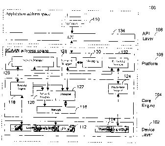
The 9GAAN system 100 of Figure 10 is designed to operate within a cluster of
several
nodes, each of which we refer to as the peer in the 9GAAN. It is understood
that the
architecture is identical at each of the peers and that the peers in the 9GAAN
1o community communicate via an ad hoc wireless network.
Figure 10 shows an embodiment of the mobile ad hoc network system (9GAAN
system) 100. The 9GAAN system 100 includes a hierarchy of layers that are
identified
as follows (see Figure 1 and the accompanying discussions for more details).
~ Device Layer 102 - The physical interface to incoming and outgoing
information
~ Core Engine 104 - Provides communication between a Platform layer 106
and the Device layer 102
~ Platform 106 - Manages the peer network and handles all aspects of
information management.
~ API 108 - The interface to an application layer 110.
6.1 Architecture Overview
The architecture implements the core network-centric computing technology,
which
provides a set of simple lightweight and flexible protoc;ols/services to
support P2P
collaboration across an ad hoc wireless network which links the mobile ad hoc
network peers.
The architecture has been organized to allow for maximum versatility. The
division
CA 02437926 2003-08-20
21
into the layers outlined above ensures that any changes made to the
implementation
of a particular layer will not affect the Platform 106 of the 9GAAN 100. This
is
particularly important when considering the bottom two layers. Within the
Device
Layer 102, the communication interfaces will initially be implemented as stand
alone
third party components. These interfaces may be replaced by other
technologies.
Due to the design of the 9GAAN system 100, these changes can be absorbed
within
the Core Engine 104, unknown to the Platform 106 or higher layers. Changes to
the
network and transport protocols employed within the Core Engine 104 may also
be
required. Again, the Platform 106 and higher layers will not be affected, as
they
1o remain isolated from the details of the Core Engine 104 implementation.
6.2 Device Layer
The Device Layer 102 includes a LinkIPhysical layer 112 and a GPS Receiver or
similar Positioning Receiver 114.
LinklPhysical 112: This is the base layer for wireless communications. It
handles
the physical transmission and receipt of radio signals between end users as
well as
offering link layer support for point to point and point to multi-point
communications.
This layer accesses all higher layers in the architecture model through a
driver
interface. This design allows the platform independence from the particular
radio
2o technology implemented at this level.
Positioning Receiver 114: Provides position information to the platform in the
form
of formatted sentence types. A common positioning receiver is GPS. Currently,
most
hand-held GPS receivers support the NMEA 0183 standard. Popular aviation
receivers built by Garmin use a similar format called the Aviation Data
Format.
6.3 Core Engine
The 9GAAN system 100 is an executable running as a~ service or daemon. It
provides
CA 02437926 2003-08-20
22
the mobile ad hoc networking for the 9GAAN devices and P2P platform support.
The Core Engine 104 includes a Network layer 116, a Routing Engine 118, a
Network
Wrapping layer 120, a Transport layer 122 and a Positioning Support layer 124.
Network 116: The Network layer 116 is responsible for moving transport layer
segments from one host to another. It must support point-to-point duplex
communication between neighboring nodes. The Network layer 116 is easily
replaced in our architecture design as all interaction with other layers takes
place
1o through predefined interfaces.
Routing Engine 118: The Routing Engine 118 is responsible for forming ad hoc
networks over highly mobile notes. It discovers and maintains routes between
any of
the pre-defined nodes in a network.
Network Wrapper 120: The Network Wrapper layer 120 is a predefined interface
between the Network and Network Manager layers. It provides a standard set of
API's so that all network layer details are hidden from l:he Network Manager.
This
ensures that the platform will function independent of the network protocol
2o implemented.
Transport 122: The transport layer 122 is responsiblf~ for passing all forms
of data
between the application layer and the network. This layer should offer a
minimum of
the following two services: a connectionless asynchronous transport service
for time
sensitive data transfer, and a connection-oriented service for reliable data
transfer.
Positioning Support 124: The Positioning Support layer 124 parses and
processes
position information. It is responsible for both local position information
passed from
a positioning receiver such as a GPS receiver, and remote positioning
information
3o that arrives over the wireless network. The Positioning Support layer
passes all
processed information to the Positioning Services layer to be used by the
platform.
CA 02437926 2003-08-20
23
6.4 Platform
The Platform 108 includes a Network Manager 126, a Transport Wrapper layer
128,
a Message layer 130 and a Positioning Services layer 132
Network Manager 126: The Network Manager 126 will maintain a table of all
current
network information (node ID's and related IP addresses, and other information
useful for management of the network). Its main duties are to discover nodes,
exchange network information, oversee the addition and deletion of network
nodes,
handle the configuration of network settings, and update and broadcast the
presence
of all nodes accessible to the network. The Network Manager 126 includes the
following services:
~5 Naming/IdentitylAddressing service: Maintains a peer's identity, uses a
network
management protocol to communicate with other peers and exchange network
information.
Neighborhood service: Up to date information about peers within range in order
to
2o enhance the task of resolving peer identity.
Session management service: Maintain the collaborative service for initiating,
terminating and restoring P2P sessions.
25 History: A cache of Information about the activities of a peer: how routes
to a peer
were established, the content of previous data communicated between peers,
etc.
Transport Wrapper 128: The Transport Wrapper layer 128 is a predefined
interface
between the actual Transport layer and higher layers. It provides a standard
set of
3o API's that can be accessed by an application directly, or through the
Messaging layer
130. The purpose of this layer 128 is to keep all details of the Transport
layer 122.
CA 02437926 2003-08-20
24
implementation abstract from higher layers.
Messaging 130: The Messaging layer 130 is used for exchanging system
information between peers. This includes the GPS, network, and status
information
of peers. Since there are multiple message types, messages are encoded in XML
so
that they can be easily sorted and processed. The Messaging layer 130 can also
provide services to the application layer, and could potf~ntially be used to
remotely
invoke methods and objects.
1o Positioning Services 132: The Positioning Services layer 132 manages all
position
related information pertaining to each node in the network. The Positioning
Services
layer 132 is not an integral part of the network, therefore it maintains a
separate
information database or table from that of the Network Manager 126. This
information is indexed by node ID.
6.5 API Layer
The APL layer 108 includes an API 134.
2o API 134: Interacts with the application and functions as a call stub in the
application
address space. It will communicate with the 9GAAN system 100 via inter-process
communication or some other mechanisms to protect the 9GAAN system 100.
The API layer 108 can be expanded to become Application Platform 134A of
Figure
11. The Application Platform 134A of Figure 11 can serve as a staging of the
solution,
allowing us to begin marketing a complete solution in a staged fashion,
starting with
the simple Level 1 and moving to the greater complexity of Level 4.
This Application Platform 134A sits on top of the Core Platform 140 of the
9GAAN
3o system 100 (Core 9G Platform). The Application Platform 134A is used and/or
provided as an API (134) to allow for rapid application development.
CA 02437926 2003-08-20
6.6. Routing Engine
The following is the use case diagram for the Routing Engine 118 of Figure 10.
5 Figure 12 shows an example of the operation of the Routing Engine 118.
6.6.1 Actors
6.6.1.1 User
The User actor 200 of Figure 12 is a human user of the Routing Engine.
6.6.1.2 Transport
The Transport actor 22 of Figure 12 represents the transport system. The
transport
system sends and receives data through the network. It allows the 9GAAN
Routing
Engine 118 to send and receive control packets through the network.
6.6.2 Use Cases
6.6.2.1 Manage Route Table
This use case provides the capability to manage the route table for the
Routing
Engine 118. It begins when the route table needs to be accessed. The
activities are:
~ FIND ROUTE
~ ADD ROUTE
~ UPDATE ROUTE
~ DELETE ROUTE
~ MAINTAIN ROUTE TABLE
CA 02437926 2003-08-20
26
6.6.2.2 Log Routing Engine
This use case begins when the User actor 200 chooses to enable logging the
routing
engine. It ends when the routing engine is stopped or the User actor 200
chooses to
disable logging the routing engine. The activities are:
~ ENABLE/DISABLE LOGGING ROUTING ENGINE
6.6.2.3 StartlStop Routing Engine
This use case begins when the Routing Engine 118 starts/stops. It ends when
the
operation is completed with or without success.
6.6.2.4 Process Routing Message
This use case begins when the Transport actor 202 receives a routing message
and
asks the routing engine to process it. The use case ends when the routing
message
is processed with or without success. The activities are:
~ PROCESS ROUTING MESSAGE
PROCESS ROUTING MESSAGE
The Transport actor 202 receives a routing message on the predefined port and
calls
the routing engine to process the routing message. The routing engine parses
the
routing message and determines what to do based on the routing message type.
The
details of decision making are specified by the actual routing protocol and
are not
known at the generic routing engine abstraction level.
3o 6.6.2.5 Maintain Local Connectivity
CA 02437926 2003-08-20
27
This use case begins when the Routing Engine 118 receives a hello message or
it is
the time to maintain connectivity status to its neighbors. The use case ends
when the
operation completed with or without success. The activities are:
~ BROADCAST HELLO MESSAGE
~ PROCESS HELLO MESSAGE
MAINTAIN LOCAL CONNECTIVIY
~ UPDATE BLACKLIST
1o The Routing Engine 118 maintains the connectivity to its active neighbors.
If it does
not receive any packets from a neighbor, it assumes that the link to the
neighbor is
lost. It will first try to repair the affected routes by starting the Discover
Route use
case. If the operation fails, it will broadcast a route error message by
starting the
Handle Route Error use case.
Figure 13 shows the operation of the Routing Engine 118 of Figure 12 for
broadcasting Hello Message. Figure 14 shows the operation of the Routing
Engine
118 of Figure 12 for processing Hello Message.
6.6.2.6 Handle Route Error
This use case begins when a route error condition arises. The use case ends
when
the route error is handled. The activities are:
~ HANDLE BROKEN LINK
~ HANDLE UNREACHABLE DESTINATION
~ PROCESS ROUTE ERROR MESSAGE
6.6.2.7 Route Discovery
This use case begins when the Transport actor needs to find a new route to a
given
CA 02437926 2003-08-20
28
destination or the existing route is invalid. It ends when the operation is
completed
with or without success. The activities are:
~ DISCOVER ROUTE
~ REPAIR BROKEN ROUTE
DISCOVER ROUTE
Figure 15 shows the operation of the Routing Engine 118 for discovery Route.
The Routing Engine 118 first tries to find a valid route to the given
destination from the
route table. If the destination is found, the use case ends. Otherwise, the
Routing
Engine 118 tries to build a route request and broadcasts the request. It then
waits for
the corresponding route reply and uses the reply to create or update the route
entry
in the route table. If the Routing Engine 118 does not receive the route reply
within
certain period of time, it tries to re-broadcast a new route request. The
Routing
Engine 118 repeats the re-broadcast until it gives up.
REPAIR BROKEN ROUTE
A destination may be unreachable caused by broken link to the next hop. A
special
route discovery activity occurs when a broken route is being repaired.
6.6.2.8 Process Route Request
This use case begins when the routing engine receives a route request. The use
case
ends when the route request is processed with or without success. The
activities are:
~ DROP ROUTE REQUEST
~ FORWARD ROUTE REQUEST
~ GENERATE ROUTE REPLY
CA 02437926 2003-08-20
29
Figure 16 shows the operation of the Routing Engine 118 of Figure 12 for
processing
Route Request.
6.6.2.9 Process Route Reply
This use case begins when the routing engine receives a route reply. The use
case
ends when the route reply is processed with or without success. The activities
are:
~o ~ UPDATE ROUTE
~ FORWARD ROUTE REPLY
Figure 17 shows the operation of the Routing Engine 118 of Figure 12 for
processing
Route Reply.
~ 5 6.6.2.10 Process Route Error Message
This use case begins when the routing engine receives a route error message.
The
use case ends when the route error is processed with or without success. The
activities are:
~ UPDATE ROUTE
~ FORWARD ROUTE REPLY
Figure 18 shows the operation of the Routing Engine 118 of Figure 12 for
processing
Route Error Message.
6.6.2.11 Repair Broken Route
This use case begins when a route error condition arises and the routing
engine opts
3o to repair the affected route. The use case ends when the route repair is
completed
CA 02437926 2003-08-20
with or without success. The activities are:
REPAIR BROKEN ROUTE
5 Figure 19 shows the operation of the Routing Engine 118 of Figure 12 for
repairing
Broken Route.
6.6.2.12 Control Route Request Dissemination
This use case begins when the routing engine needs to broadcast a route
request. It
uses some algorithm to control the amount of network traffic caused by route
discovery messages. The use case ends when the route request is built for
broadcast. The activities are:
15 ~ CONTROL ROUTE REQUEST DISSEMINATION
6.6.2.13 Update Route to Previous Hop
In this use case, the routing engine tries to establish or update a route to
the previous
2o hop based on the received routing message.
1. Preconditions
a. The Transport receives a routing message.
25 b. The underlying link layer supports bidirectional communications.
2. Main Flow
This use case begins when the routing engine receives a route message. The use
3o case ends when a route is established to the previous hop or the operation
fails. The
preconditions are:
CA 02437926 2003-08-20
31
~ The Transport receives a routing message
~ The underlying link layer supports bidirectional communications
The activities are:
~ UPDATE ROUTE TO PREVIOUS HOP
UPDATE ROUTE TO PREVIOUS HOP
The Transport actor 202 receives a routing message. It calls the routing
engine to
parse the routing message. Upon successful parsing, the Routing Engine 118
tries to
establish a route to the previous hop where the routing message is from. The
concrete route update is specific to the actual routing protocol and the
details are not
known at the generic routing engine abstraction level.
6.7 Network Wrapper
The following is the use case diagram for the Network ll~Jrapper 120 of Figure
10.
2o As shown in Figure 20, the operation of the Network Wrapper 120 includes:
Get
Routes; Add Route; Update Route; Delete Route and Get Interfaces.
6.7.1 Actors
6.7.1.1 User
The User actor 200 is a human user of the 9GAAN Airborne Fire Fighting System
or
an external system.
6.7.2 Use Cases
CA 02437926 2003-08-20
32
6.7.2.1 Get Routes
This use case is started when the User actor 200 chooses to get route entries
from
the native route table for a given destination, gateway, and interface.
6.7.2.2 Add Route
This use case is started when the User actor 200 chooses to add a route entry
to the
native route table for a given destination, gateway, and interface.
6.7.2.3 Update Route
This use case is started when the User actor 200 chooses to update a route
entry
(gateway and interface) in the native route table.
6.7.2.4 Delete Route
This use case is started when the User actor 200 chooses to delete a route
entry from
the native route table.
6.7.2.5 Get Interfaces
This use case is started when the User actor 200 chooses to get all the
network
interfaces on the native operating system.
6.8 Network Manager
The following is the use case diagram for the Network Manager 126 of Figure
10.
As shown in Figure 21, the operation of the Network Manager includes: Add
note;
3o Update Note; Remove note; Register Network Manager Clients; and Notify
Network
Changes.
CA 02437926 2003-08-20
33
6.8.1 Actors
None.
6.8.2 Use Cases
6.8.2.1 Add Node
This use case is started when a new node is detected. Pts IP address is
assigned and
broadcast across the cluster.
6.8.2.2 Update Node
This use case is started when the node receives network information from its
peer.
They negotiate IP addresses and broadcast the results,
6.8.2.3 Remove Node
2o This use case is started when a node in the cluster is found unreachable
and the
information is broadcasted to remove the node from the cluster.
6.8.2.4 Register Network Manager Clients
This use case is started to register/unregister Network Nlanager clients for
receiving
network info update messages.
6.8.2.5 Notify Network Changes
3o This use case is started to notify the registered Network Manager clients
of network
changes (node addition, removal, and update).
CA 02437926 2003-08-20
34
6.9 Transport Wrapper
The following is the use case diagram for the Transport Wrapper 128 of Figure
10.
As shown in Figure 22, the operation of the Transport Wrapper 128 includes;
Create
passive socket; Create socket; Accept connection requests; Connect;
Send/Receive
datagrams; SendlReceive stream data. The transport wrapper passes the data in
theses requests to the network layer for transmission over the radio data
network. A
socket address is a TCP/IP network address which provides addressing to
particular
1 o devices on the network.
6.9.1 Actors
6.9.1.1 Application
The Application actor 204 is an application that is built tin the 9GAAN
platform.
6.9.2 Use Cases
6.9.2.1 Create Passive Socket
This use case is started to create a passive socket for service connection
pointer.
6.9.2.2 Create Socket
This use case is started to create a generic socket for communication end
point. Two
types of sockets can be created -- stream and datagram sockets.
6.9.2.3 Accept Connection Requests
This use case is started to accept connection requests.
CA 02437926 2003-08-20
6.9.2.4 Connect
This use case is started to connect to a well-known communication port on a
specified
5 host.
6.9.2.5 Send/Receive Datagrams
This use case is started to send and receive datagrams.
6.9.2.6 Send/Receive Stream Data
This use case is started to send or receive stream data over a TCP connection.
6.10 Positioning Support
The following is the use case diagram for the Positioning Support 124 of
Figure 10.
As shown in Figure 23, the operation of the Positioning Support includes: Get
GPS
NMEA sentences; and Parse NMEA sentences from GPS receivers.
6.10.1 Actors
6.10.1.1 Positioning Receiver
The Positioning Receiver actor 206 represents the positioning receiver system.
It
allows the 9GAAN system to receive positioning information from the satellite
or other
sources.
6.10.2 Use Cases
CA 02437926 2003-08-20
36
6.10.2.1 Get NMEA Sentences
This use case is started to communicate with a GPS Receiver and retrieve GPS
NMEA sentences.
6.10.2.2 Parse NMEA Sentences
This use case is started to parse NMEA sentences and extract the GPS info. It
is
used by other use cases for GPS support.
6.11 Positioning Services
The following is the use case diagram for a Positioning Service 132 of Figure
10. As
shown in Figure 24, the operation of the Positioning Services 132, from a GPS
receiver for example, includes: Get GPS info; Update Network Info; Start/Stop
GPS
Services; register GPS Services Clients; Update Local GPS Info; Notify GPS
Changes; Update Remote GPS Info; and Broadcast GPS Info.
6.11.1 Actors
6.11.1.1 Positioning Receiver
The Positioning Receiver actor 206 represents the Positioning receiver system.
It
allows the 9GAAN system to receive position information from a satellite, for
example.
6.11.2 Use Cases
6.11.2.1 Get GPS Info
This use case begins when the client retrieves GPS information for a specified
node.
CA 02437926 2003-08-20
37
6.11.2.2 Update Network Info
This use case is started to update network info from the Network Manager 126
of
Figure 10.
6.11.2.3 Start/Stop Positioning Services
This use case begins when the administrator chooses to start/stop the
Positioning
Services. It ends when the operation is completed with or without success.
6.11.2.4 Register Positioning Services Clients
This use case is started to register/unregister Positioning Services clients
for
~ 5 receiving positioning information update messages.
6.11.2.5 Update Local Position Info
This use case is started to retrieve and process local position information
from the
2o Positioning receiver such as a GPS receiver 206 periodically at a pre-
configured
frequency. It then notifies the registered clients of positiion information
changes and
broadcasts the local position info to all the nodes in the cluster.
6.11.2.6 Notify Position Changes
This use case is started to notify all the registered Position Services
clients of position
information changes. It ends when the operation is complete.
6.11.2.7 Update Remote Position Info
This use case is started to update remote Position information on the network.
It
CA 02437926 2003-08-20
38
receives and processes position information from remote nodes. It then
notifies the
registered clients of position info changes.
6.11.2.8 Broadcast Position Information
This use case is started to broadcast the local position information to all
the nodes in
the cluster.
7. Forestry Fire Fighting
The following is the use case diagram for the Forestry Fire Fighting. Each
individual
package contains its own use case diagram. Figure 2;~ shows the operation for
Forestry Fire Fighting provided by the 9GAAN system 100 of Figure 10.
7.1 Common GUI Operations
The following is the use case diagram for the Common GUI Operations of Figure
25.
Figure 26 shows the operation of the Common GUI Operations shown in Figure 25.
7.1.1 Actors
7.1.1.1 User
The User actor 200 is a human user of the 9GAAN Airborne Fire Fighting System
or
an external system.
7.1.2 Use Cases
7.1.2.1 Zoom
This use case begins when the User actor 200 chooses to change the GUI display
CA 02437926 2003-08-20
39
scale. The screen adjusts to display according to the selected zoom. Or the
system is
configured to automatically select the zoom to display all the nodes in the
cluster.
This use case may apply to multiple views.
7.1.2.2 Display Terrain Info
This use case starts when the User actor 200 chooses to display the terrain
information and the system displays it in the background with the correct
coordinates.
7.2 Fire Fighting Engine
The following is the use case diagram for the Fire Fighting Engine of Figure
25.
Figure 27 shows the operation of the Fire Fighting Engine shown in Figure 25.
~ 5 7.2.1 Actors
7.2.1.1 User
The User actor 200 is a human user of the 9GAAN Airl'~orne Fire Fighting
System or
2o an external system.
7.2.2 Use Cases
7.2.2.1 Update Aircraft Profile
This use case is started to update the aircraft profile (aircraft type). When
a new
(remote) aircraft enters the network or an existing one leaves, the
corresponding
profile in the system needs update. The other scenario is for the User actor
to set the
aircraft profile manually or automatically and the aircraft profile info is
broadcast.
CA 02437926 2003-08-20
7.2.2.2 Update Fire Info
This use case begins when the User actor 200 updates fire information or the
system
receives a fire info update broadcast. Fire info includes fire location and
status (fire,
smoke, out). If the User adds or removes a fire spot, the fire information
change gets
broadcast to all the aircraft in the network. When the local aircraft receives
a fire info
change, it will update the fire information in the system and display the
information
accordingly.
7.2.2.3 Update Aircraft Status
This use case begins when status of an aircraft (water' status) has changed or
the
update info has been received. The User actor 200 may cause aircraft status
changes. The info is broadcast to all the aircraft in the network cluster.
When the local
aircraft receives an aircraft status update, it will update the system about
the
associated aircraft and carry out the display accordingly.
7.2.2.4 Update Assignment Info
2o This use case begins when assignment information has changed. An aircraft
may
have accepted a new fire fighting assignment or dropped one. It may have
received
fire fighting assignment info over the network. The fire fighting assignment
includes
information on the fire location and assignee.
25 7.2.2.5 Manage Assignments
This use case starts when the User actor 200 assigns a fire-fighting task to
an aircraft
(may be the local). The assignee either accepts or rejects the assignment. If
it
accepts, the assignee broadcasts the assignment inforrr~ation (task and
aircraft). The
3o fire fighting assignment activity involves a sequence of client/server
request/response exchange between the assigner and assignee.
CA 02437926 2003-08-20
41
7.2.2.6 Broadcast Operational Info
This use case is started to broadcast fire fighting information to all the
nodes in the
network. It uses the Messaging services to create XML documents and broadcast
them.
7.3 Operational View
1o The following is the use case diagram for the Operatianal View of Figure
25. Figure
28 shows the operation of the Operational View showin in Figure 25.
7.3.1 Actors
7.3.1.1 User
The User actor 200 is a human user of the 9GAAN Airborne Fire Fighting System
or
an external system.
7.3.2 Use Cases
7.3.2.1 Display Aircraft Operational Info
This use case begins whenever the position information, status, and profile of
an
aircraft have changed. This use case extends the Display Aircraft Traffic
Information
use case. It displays different images to show aircraft types. It uses color
code to
show the aircraft water status (green = full, red = empty).
7.3.2.2 Display Fire Info
This use case begins when fire information (location, status, and assignment)
has
CA 02437926 2003-08-20
42
changed. It displays fire location relative to the local aircraft and fire
status (fire = red,
smoke = yellow, out = green).
7.3.2.3 Display Aircraft Assignments
This use case starts when fire fighting assignment info has changed. It
displays the
type of fire fighting tasks, aircraft responsible, and the status of the
tasks. It uses
dotted lines between aircraft and fire spots to indicate the fire fighting
task
assignments.
7.4 Traffic View
The following is the use case diagram for the Traffic View of Figure 25.
Figure 29
shows the operation of the Traffic View shown in Figure 25.
7.4.1 Actors
7.4.1.1 User
2o The User actor 200 is a human user of the 9GAAN Airborne Fire Fighting
System or
an external system.
7.4.2 Use Cases
7.4.2.1 Display Distance Rings
This use case starts when the User actor 200 chooses. to display distance
rings. The
screen displays distance rings to facilitate the User actor 200 to judge
positions of
nodes in the cluster.
CA 02437926 2003-08-20
43
7.4.2.2 Display Danger Level
This use case starts when the User actor 200 chooses to display danger level
of other
aircraft in the cluster. If another aircraft is considered in a collision
course, it will be
displayed differently to indicate to the User actor 200 of danger of different
levels.
7.4.2.3 Display Aircraft Traffic Info
In this use case, position information of aircraft (location, altitude, speed,
course, and
climb) is displayed. The local aircraft image is displayed in the center of
the screen
and points to its course of motion. The position information text of the local
aircraft is
displayed in the top part of the screen. The remote aircraft are displayed as
moving
dots in the screen, with their location relative to the local aircraft. The
directions of
motion of the remote aircraft are expressed as a lines originating from the
dots. The
~5 speed, distance, and altitude of the remote aircraft arE: displayed as
texts moving
along with the dots. The use case begins when position information of any of
the
aircraft in the cluster is updated.
8. Alternate Embodiments of the Invention
8.1 Emergency Response
Alternately the invention may be used for emergency response applications. In
this
embodiment ambulances and fire engines form a mobile ad hoc network for aiding
in
emergency situations. The display in this embodiment shows other emergency
vehicles at the emergency scene, transmits positional and other data to
coordinate
rescue efforts.
8.2 Police Patrols
Alternately the invention may be used to coordinate police work such as
coordinated
CA 02437926 2003-08-20
44
chases or the like. In this case police vehicles may communicate data between
all
vehicles involved, and transmit positional information. The network transmits
data
securely so that a criminal element may not intercept sensitive data.
8.3 Intelligent Sensor Networks
Alternately the invention may be used in intelligent sensor networks. In this
case the
network elements contain sensor which share data such as warehouse contents,
or
truck load contents, which can be shared amongst the network elements.
8.4 Transportation Tracking
Alternately the invention may be used in transportation to track vehicle,
train, or etc.
location and load contents. The devices in this case transmit data such as
text, voice,
and contents tracking information including but not limited to vehicle
contents, weight,
disposition, destination location, etc.
8.5 Disaster Recovery
2o Alternately the invention may be used to quickly set up networked
communication in
areas where natural disasters, physical disasters, or ether have rendered
existing
network infrastructure inoperable. The devices would use their self-forming
network
capabilities to enable the exchange of data, positional information,
instrument or
sensor data, voice, video or other in a time critical environment.
8.6 Search and Rescue
Alternately the invention may be used in search and rE~scue operations to
allow the
sharing of information between ground stations, vehicles, or patrols, airborne
3o vehicles, and marine vessels. The device will allow rescue teams to
coordinate efforts
by sharing precise positional information in real-time. The device would also
allow for
CA 02437926 2003-08-20
digital marking of searched and un-searched locations, geographic and
topological
referencing, assignment of targets and tasks, and data logging. The device
would
also allow the input and sharing of user defined areas such as avalanche
zones, flood
regions, infrastructure collapse, etc.
5
8.7 Public Transit
Alternately the invention may be used by transportation systems to report
positional and kinematics information. The device would allow public transit
vehicles
1 o to report positional and prospective arrival times to destinations and
stops. The
device would also allow sharing of traffic information, road conditions, and
connection
information between vehicles.
8.8 Surveying and Remote Region Communications
Alternately the invention may be used in land based; air to land or air based
geographical surveying or other remote location work where communication is
required. The device would allow the sharing and marking of geographic
location,
exchange of sensor information, data and voice communication, and could be
used
2o to coordinate team positions and tasks.
8.9 Hospital Patient Tracking
Alternately the invention may be used to track the precise location of
individuals
within a particular institution or area. One application for the device would
be the
tracking of patients while in hospital. The device would relay position and
patient
information to hospital staff, while allowing 2 way messaging and other forms
of data
exchange.
8.10 Armed Forces Communications
CA 02437926 2003-08-20
46
Alternately the invention may be used to provide all forms of information
sharing
between armed forces teams in an ad hoc environment. The primary target would
be
supply teams, where the device would be used to exchange positional
information of
resources.
9. Routing Metrics
Introduction:
A routing metric is a parameter used by an operating system, network protocol
or
routing engine to gain knowledge about the efficiency of a particular route.
In the field
of ad hoc networking, the routing metric is of particular importance as often
there are
several possible routes between cluster nodes and the metric determines the
route
selection. An intelligent process for establishing route mf=trics ensures that
the most
~5 efficient routes are consistently chosen, limiting network utilization and
overhead, and
providing the best end-to-end performance over the network.
We propose "The Use of Local and Remote Node Position information to Establish
Route Metrics in a Wireless Ad Hoc Network".
In this approach, position information consisting of but not limited to the
precise
latitude, longitude, altitude, velocity, course, time, and magnetic variation
of each
node in a network is circulated regularly throughout the network.
Scenario 1. Route Determination
When a node requires a route to another node in the network, or must decide
between multiple routes, the 3 dimensional positions of Each potential
intermediate
node in the network can be used to establish a metric for all possible routes
between
3o end nodes. The latitudes, longitudes, and altitudes can be used to
calculate the 3
dimensional straight line distances between each hop in a route, and assign a
metric
CA 02437926 2003-08-20
47
that reflects the reliability of the wireless link at this distance. For
example, below
some distance threshold where link reliability is fairly high, the routing
metric for each
hop might increase linearly with distance whereas above the threshold the
routing
metric might increase exponentially to reflect the effect of far-field signal
degradation
on link performance.
As a variation of the above process, the latitude and longitude could be used
to
calculate the 2 dimensional above ground distance between nodes, to form a
coordinate set with the difference in node altitude. These coordinates could
be
checked against the E plane and H plane signal distributions of the
transmitter/receiver pairing between nodes. Coordinates well inside the signal
distribution range would generate favorable hop metrics, increasing linearly
as the
coordinates approach a spatial distribution threshold, and increasing
exponentially
outside the threshold.
In addition to node locations, node velocities might also be used stand-alone
or in
combination with location information to establish routing metrics. Similar to
the
location process above, the relative velocities of potential intermediate
nodes would
be calculated and a metric assigned that reflects the expected reliability.
The metric
2o could reflect the Doppler effects between nodes given their relative
velocities and
communication frequencies, and/or known or measured relative velocities that
provide good/poor link performance.
Scenario 2. Predictive Route Changes
In mobile ad hoc networks it is not uncommon for nodE~s to move outside of the
communication range with its neighbors. When this occurs, the node will lose
communication with its neighbors as well as any nodes it was communicating
with by
routing through these neighbors and vice versa. Instead of waiting for this
loss of
3o communication to happen we propose a scheme where Position and Geographic
Information System (GIS) information is used to predict this loss of
communication
CA 02437926 2003-08-20
48
and take action to search for new routes and hand-off existing routes in such
a way
as to minimize interruptions to all network traffic. This predictive algorithm
would use
the precise location information, velocity, course and other position
information of all
relevant nodes to determine when a particular node is likely to lose a
communication
point in the network. As this probability increases, the routing metric for
all routes
involving the node of concern would increase. At some threshold, the routing
engine/network protocol/operating system would react by looking for
replacement
routes but without halting communication. If routes with a more favorable
metric are
discovered, traffic will be re-routed.
CA 02437926 2003-08-20
49
10. Distributed Address Allocation
10.1 IP Address Resolution Algorithm
Assumptions
~ The MAC address is globally unique and used as the node ID.
~ A public IP(v4) address space is available.
~ An evenly distributed and efficient hashing algorithm is available.
Each node periodically broadcast hello messages.
Description
A portion, A, of the public address space (e.g. IPv4 type C) is allocated for
the
~5 address resolution algorithm.
A node uses the MAC address as its ID. It also keeps a monotonically
increasing
index in its registry. The node derives an (IPv4) address by hashing its MAC
address
and the index. The index is incremented by one after each address computation.
Assume that all the nodes in a cluster C have obtained unique addresses.
Scenario 9.
A standalone node comes into contact with the cluster C. It realizes that it
is not part
of the cluster and initiates the IP address resolution process. It derives an
IP address
by the above algorithm and broadcasts it. A node in C receives the IP address.
It
checks to ensure that the received IP address is not in conflict with existing
ones in
C.
~ The proposed IP address is not in conflict, the receiving node in C
broadcasts
CA 02437926 2003-08-20
back a confirmation for the proposed IP address.
The proposed IP address is in conflict, the receiving node in C broadcasts
back a rejection message. The independent node derives a new IP address
5 and repeats the process until a unique IP address is resolved.
After the standalone node obtains an IP, it retrieves the network info from
the contact
node in C. The contact node in C floods info on the nE;w node to the cluster.
CA 02437926 2003-08-20
51
Scenario 2.
Two network clusters, C and D, come into contact. The contact nodes exchange
network info. One of them, say the contact node in C, checks the IP addresses
within
its own cluster and resolve the conflicting ones. The contact node in C
notifies those
nodes in C that they need to resolve the conflict. The nodes derive new unique
IP
addresses (within C) and send them to the contact node in C, which checks to
ensure
that the new IP addresses do not conflict with those in D. If a new IP address
is found
in conflict, the contact node in C negotiates with the corresponding node in
its cluster
1o for a new one. When all the conflicting IP addresses acre resolved, they
are passed to
the contact node in D. The change in IP address is flooded within the two
individual
clusters and they are merged.
Summary
The IP address is derived from the MAC address. Therefore, if the IP address
space
in the algorithm is large compared to the number of nodes, the likelihood of
conflicting
IP addresses is small. The IP address resolution overhead is expected to be
small.
10.2 NAT Address Translation and Connecting to t:he Internet
A useful feature of the 9GAAN is its ability to merge with the Internet. To
accomplish
this, one or more cluster nodes must act as a bridge to an external network.
The
bridging node is responsible for multiplexingldemultiplexing all traffic
flowing between
the cluster and the Internet.
Before bridging occurs, the potential bridge node must advertise the external
network
to the other cluster nodes. The proposed scheme for such advertising is by
sending
device specific information within messages created and processed by the 9GAAN
3o messaging layer. These messages will carry descriptive information
outlining the
physical characteristics of the device, its interfaces, and network
connections, its
CA 02437926 2003-08-20
52
ability to bridge communication, and its capabilities in terms of information
and
application sharing. In the event that more than one cluster node advertises
as a
bridge, the Routing Engine will determine which bridge to use taking into
account the
amount of traffic flowing through each bridge.
To act as a bridge, a cluster node must provide network address translation
(NAT)
between the network cluster and the Internet. The node will make use of
communication ports, unique identifiers, communication flags, and other to
properly
map incoming/outgoing traffic to the appropriate destination. As well,
traditional NAT
~o techniques may be enhanced to compliment 9GAAN's ability to support highly
dynamic environments. For example, current NAT schemes could be extended to
allow seamless hand-off of a cluster node from one cluster bridge to another.
This
would require NAT coordination between bridges and a form of hand-off
negotiation,
but would offer uninterrupted Internet communication as nodes move through
bridge
zones.
11. Maximum Doppler Spread Between Wireless Cards
Traveling in aircraft each flying at 150mph directly towards or away from each
other
(worst case scenario).
V = 134.08 m/s Relative velocity in meters per second
802.11 b
Center Frequency Wavelength Max Doppler Spread
Channel 1 2.412E+09 1.243E-01 1078.78Hz
Channel6 2.442E+09 1.228E-01 1092.19Hz
Channel 11 2.472E+09 1.213E-01 1105.61 Hz
The Doppler spread is equal to the relative velocity of the transmitter with
respect to
CA 02437926 2003-08-20
53
the receiver, divided by the Wavelength of the signal, multiplied by the
cosine of the
spatial angle between the direction of motion of the receiver and the
direction of
arrival of the signal. The maximum spreading will occur when the angle is
zero.
This happens when the devices are moving directly tovvards or away from each
other.
For the 9GAAN network, the relative velocities will continually change but may
be
considerably less than 300mph for extended periods of time (aircraft flying in
the
same direction towards the target is one example). Thus the spreading would be
significantly less than the maximum. Also, the fact that airplanes will
frequently fly at
different altitudes will increase the angle between the direction of motion
and the
direction of the received signal which will also reduce the Doppler spreading.
For a complete analysis, we could generate a scenario between aircraft, and
use their
~5 relative velocities over their Flight paths to calculate the Doppler
spreading of signals
sent between them. However, since we presently have no control over the
receiver
sensitivity, we should determine if the maximum Doppler spread can be handled
by
our receivers.
The 9GAAN network can use its routing algorithm to effectively ameliorate
Doppler
2o effects by setting the multi-hop path to use a third node not collinear
with the other
nodes to mediate communications. The third node would thus have lower Doppler
shift and not be affected to the extent of two nodes directly flying towards
one another
Figure 31 shows 3 modes, A, B and C. The maximum Doppler shift is between
Nodes
A and B, approaching directly head-on. The relative velocity between A and C,
and
25 between B and C is relatively much lower and the resulting Doppler shits
are much
lower. Thus if A and B communicate by multi-hopping though C, then the Doppler
effects are not as pronounced.
12. Aircraft Mounted 10 Devices for Pocket/Tablet PC
The initial application of our device will require installation and operation
in and
CA 02437926 2003-08-20
54
around the aircraft instrument panel. Since it may not always be convenient
for the
pilot/crew to use the device's standard input/output, alternate forms of
input/output
are proposed.
Control Mounted Toggle Switch System
A switch system would be fastened to the control column allowing the pilot/co-
pilot to
interact with the device. The switch system would be used to set/mark way
points,
assign tasks, and set status information.
Control Mounted Scroll Wheel and Trigger
Attached to the aircraft control column, the scroll whet=I would allow the
pilot/co-pilot
to scroll through menus, screens, and select objects, while the trigger would
act as an
action button.
Voice Activated Interface
Connecting a standard aircraft headset to the device, this interface would
interpret
2o and input voice commands from the operator. The voice input would allow
aircraft
selecting and assignment by call sign or other, status updates, position
marking and
description, etc. Voice output or other sound would provide feedback to the
operator.
According to the present invention, the mobile ad hoc network integrates
multiple
data sources such as position (e.g. GPS, aircraft transponder data) and other
critical
information into a wireless multi-hop data network. The network is self-
forming and
self-healing so it is applicable for use in remote mobile situations where
network
infrastructure is not available.
Summary
The mobile ad hoc network of the present invention provides reliable means of
data
CA 02437926 2003-08-20
communication in remote locations for allowing the devices to self-form into a
network, whereby the devices may dynamically enter and leave the network. It
also
extends the wireless range, and allows routing around physical obstacles such
as
mountains and buildings, by allowing multi-hop routing whereby each device in
the
5 network acts as a router/repeater. In airborne firefighting, this gives much
greater
reliability, range, and flexibility to data communication.
The present invention allows positional and other critical information to be
shared in
real time with greater accuracy, thus increasing safety and team operational
effectiveness.
The invention solves the problem of communication and coordination of
mobile teams in remote situations where fixed data network infrastructure is
not
available. It enables the coordination and tracking of aircraft, vehicles,
ships, people,
~ 5 and other mobile things, and the sharing of critical information in real
time, by the use
of peer-to-peer application on a self-forming ad hoc wireless radio data
network.
While particular embodiments of the present invention have been shown and
described, changes and modifications may be made to such embodiments without
2o departing from the true scope of the invention.