Note: Descriptions are shown in the official language in which they were submitted.
CA 02442253 2003-09-26
WO 02/079800 PCT/EP02/00350
Societe Europeenne des Satellites S.A.
Ranging System for Determining Ranging Information of a
Spacecraft
The invention refers to a ranging system and a ranging
method for determining ranging information of a spacecraft
carrying a component of a communication channel.
Furthermore, the invention. refers to a receiving station
and a method for operating a receiving station, a
processing station and a processing method, a spacecraft
and a method for operating a spacecraft, and a transmission
unit and a method for operating a transmission unit.
2o Geo-stationary communication satellites have to be
positioned in precisely defined space segments assigned by
the Tnternational Telecommunication Union (TTU). However,
the combined effect of oscillations of a period of 24 hours
due to the inclination and eccentricity and the long-term
drift of the main longitude leads to an apparent movement
of the satellite with respect to its nominal position.
Therefore, the satellite has to be controlled under the
effect of these perturbations by applying periodic orbit
corrections in the most economic manner so that the
3o satellite remains within the so-called station-keeping box.
For such a~~:control it is necessary to determine precisely
the position andlor movement of the satellite which is
usually addressed as ranging.
CA 02442253 2003-09-26
WO 02/079800 PCT/EP02/00350
Due to sophisticated orbit positioning techniques of geo-
stationary satellites, the requirements for the°accuracy of
ranging have increased recently. From DE 198 36 602 Al it
is known to position satellites in a so-called satellite
cluster at one geo-stationary orbit position in order to
make better use of the narrow orbit space. This means that
not just one satellite, but a plurality of satellites have
to be controlled in one station-keeping box.
1o The basic technique for determining the space coordinates
of a satellite is based on a trilateration solution as
described below. Fig. 1 shows the basic configuration of a
trilateration measurement. Three transmission stations 101,
102 and 103 are located on earth, wherein the positions P1,
P2 and P3 of each transmission station are known. If the
distances d1, d2 and d3 can be measured, then the unknown
position P4 of the satellite 104 can be determined. Let d;,
denote the distance of the corresponding measurement of
each transmission station and let (x, y, z) and (xi, y;,, z~)
2o denote the Cartesian coordinates of the satellite 104 and
each transmission station Pi, respectively. Then the
following relation holds:
di - ~x ' xi ~~ + ~y ' Yi. )~ + ~z - zi
' lx - xo ~~ + (y - Yo )2 + lz - zo )2 - fi !q1 , i = 1' 2' 3 ( 1 )
where q = ~x, y, z~T is the unknown position vector of the
satellite 104. The vector of the distance measurements is
expressed as:
3o d = f~q) (2)
2
CA 02442253 2003-09-26
WO 02/079800 PCT/EP02/00350
A commonly employed method to solve for q in this non-
linear equation is the Gauf3-Newton iterative method. The
best estimate of q is iteratively approximated as:
n n _1 _ n
qk+1 - qk+ ~FTF~ FT d - f qk (3)
where F is the Jacobian matrix:
afl aft 8f1
r7x ay az
of -_ aft aft aft (4)
aq 7x ay az
afg af3 af3
ax ay Oz
to However, in practice not only a trilateration configuration
according to Fig. 1, but any other configuration like e.g.
a bilateration or a quadrilateration configuration can be
used.
Although a bilateration does not yield the full ranging
information.of a spacecraft, a bilateration still might be
useful if only a certain coordinate of the spacecraft is of
interest.
2o Furthermore, a quadrilateration configuration allows the
solution for an additional unknown quantity. Fig. 2 shows
the practical configuration of a quadrilateration
measurement. Let say the transponder delay D of the
transponder carried by the satellite is an additional
unknown quantity besides the space coordinates of the
spacecraft. Typically, such a transponder comprises
frequency converters, high=power amplifiers etc. Then the
approach for each distance measurement di is as follows:
3
CA 02442253 2003-09-26
WO 02/079800 PCT/EP02/00350
di = D + ~x - xi ~2 + ~y - Yi ~2 + ~z - zi )2
- ~x - xo~2 + ~Y - Yo~2 + ~z - zo~2 (5)
_ fi(q) , i = 1, 2, 3, 4 ~~
where q = ~x, y, z~T is again the unknown position vector of
the satellite. The solution for q can be found by
rewriting the formulas (2), (3) and (4) accordingly. The
Jacobian matrix is then:
afi aft aft afi
ax ay az aD
of __ aft 8f2 aft aft (6)
aq ax ay az aD
afg 7f3 af3 af3
7x ay az aD
A further unknown quantity is the time delay introduced by
the receiving arrangement due to unknown delays, e.g. due
to error recovery mechanisms.
From V~10 00/48018 it is known to use two separate receiving
arrangements in one transmission/receiving station to
compensate this kind of unknown delays. Fig. 3 shows a
corresponding transmission/receiving station with a
compensation of the time delay introduced by the receiving
arrangement. The transmission and receiving station 301
comprises a multiplexer/encoder 302, a QPSK modulator 303,
an up-converter 304 and a satellite antenna 305. Digital
payload signals 306 consist of elementary data streams and
are fed to a multiplexer/encoder 302 which converts the
plurality of digital payload signals into a single digital
transport stream, for example according to the MPEG=2 and
DVB standards. The digital transport stream is modulated by
the QPSK modulator 303 and fed to the up-converter 304
which represents the equipment necessary to convert the
4
CA 02442253 2003-09-26
WO 02/079800 PCT/EP02/00350
output of the QPSK modulator 303 into a signal that can be
fed to the satellite antenna 305 for transmission to a
transponder carried by the satellite. Typically, such a
transponder comprises frequency converters,;k~igh-power
amplifiers etc.
The output signal of the QPSK modulator 303, i.e. the
modulated digital transport stream is also fed to a first
receiving arrangement 307. The processor 308 analyses the
series of samples to trace a predetermined signal pattern.
If the predetermined signal pattern is traced, the
processor 308 sends a start signal START to a time
measurement circuit 309. Upon receipt of the start signal
START the time measurement circuit 309 begins to measure
the time until it receives a stop signal STOP.
The stop signal STOP is generated by a second processor
308' receiving an output signal from a second receiving
arrangement 307'. The first and second receiving
2o arrangements 307, 307' are identical regarding their
structure and components. The input signal to the second
receiving arrangement 3071 is supplied from a down-
converter 310 which receives a signal from the satellite
antenna 305 and which comprises all the equipment necessary
to convert the received signal from the satellite antenna
305 into a signal corresponding to the output signal of the
QPSK modulator 303.
However, since the signal has travelled from the satellite
3o antenna 305 to the transponder carried by the satellite 312
and back, the received signal is delayed.
For generating the stop signal STOP, the second processor
308' traces the predetermined bit. sequence in the output
signal of the second receiving arrangement 307' in the same
5
CA 02442253 2003-09-26
WO 02/079800 PCT/EP02/00350
manner as the first processor 308. Upon detection of the
predetermined bit sequence, the second processor 308' sends
the stop signal STOP to the time measurement circuit 309
which stops the time measurement. The measured time
corresponds to the double distance between the ground
station 305 and the transponder carried by the satellite
312, wherein fixed time delays in the up-converter 304, the
satellite antenna 305, the transponder carried by the
satellite 312 and the down-converter 310 can be subtracted
1o accordingly. Since two identical receiving arrangements
307, 307' are provided, unknown delays, e.g. due to error
recovery mechanisms, can be compensated accordingly.
Fig. 4 shows a diagram of a transport stream according to
the MPEG-2 standard. The transport stream TS is a sequence
of packets basically consisting of a header H (4 bits) and
a payload P (184 bits). The header H includes
synchronisation information (1 bit), various flags
(transport error indicator, payload unit start indicator,
2o transport priority, etc.), a payload identification PID (13
bits) and a continuity counter (4 bits). The payload
identification PID is required for demultiplexing the
individual elementary data streams. An adaptation field is
optional, but is transmitted at least every 0.1 s and
contains ancillary program data, especially a program
reference clock PCR for regeneration of a 27 MHz clock at
the receiving side.
Subsequently, the transport stream TS is processed
3o according to different standards depending on the
transmission channel. For transmission via satellites, the
European DVB satellite standard (DVB-S) may be applied,
which defines among other mechanisms convolutional and
read-Solomon coding as well as additional error control
bits to be added to allow forward error correction (FEC).
6
CA 02442253 2003-09-26
WO 02/079800 PCT/EP02/00350
Similarly, European DVB standards exist for terrestrial
(DVB-T) and cable (DVB-C) broadcasting.
The predetermined bit sequence in the transport stream TS
can be used to generate trigger signals or predetermined
signal patterns on the basis of which the delay caused by
the travel path from the satellite ground station to the
transponder carried by the satellite and back can be
calculated. The predetermined bit sequence may be inserted
1o into the transport stream TS at the uplink side, for
example as a specific payload P. In order to avoid
insertion of additional packets, the program identification
PID or part of it may be used as a predetermined bit
sequence. Some PIDs must be present in the transport stream
TS, but may have a repetition rate which is too high for
the purpose of determining ranging information. Then, the
PID may be combined with other information of the transport
stream header H, e.g. the continuity counter, in order to
define a predetermined bit sequence.
On the basis of the configuration according to Fig. 2, each
station can carry out the distance measurement on its own.
In a next step, the position of the satellite can be
calculated on the basis of formulas (5) and (6) as
described above in a central processing station. However,
in order to provide independent stations, for each station
a transmission equipment has to be provided which makes
considerable investments necessary.
3o An alternative solution is the use of a so-called pseudo
ranging configuration. Fig. 5 shows the practical
configuration of a quadrilateration measurement by pseudo
ranging. Pseudo ranging in the sense of the present
application is the simple delay measurement of the time
elapsed between the transmission of a signal from one
7
CA 02442253 2003-09-26
WO 02/079800 PCT/EP02/00350
location and the reception of the same signal to another
location. In practice, one transmission station and a
plurality of receiving stations are established as shown in
Fig. 5. Preferably, one receiving station isr,.combined with
the transmission station. However, in order to determine
for each station the transmission delay, it is now
necessary to introduce a time synchronization between all
stations. Only if the receiver also knows when the
transmitter actually has sent the signal, it is possible to
2o measure the delay or so-called pseudo range. In the case of
geo-stationary satellite ranging, the delay is still
relatively short (about 250 ms) , so that the clock
synchronization needs to be highly stable for short
periods. More specifically, the synchronization accuracy
25 should be at least below 10 ns.
Naturally, the same compensation technique as known from
WO 00/48018 can be applied also for pseudo ranging. Fig. 6
shows separate transmission and receiving stations with a
2o compensation of the time delay introduced by the receiving
arrangement. The transmission station 601 comprises a
multiplexer/encoder 602, a QPSK modulator 603, an up
converter 604 and a first satellite antenna 605. Digital
payload signals 606 are elementary data streams and are fed
25 to the multiplexer/encoder 602 which converts the plurality
of digital payload signals into a single digital transport
stream, for example according to the MPEG-2 and DVB
standards as described with reference to Fig. 3. The
digital transport stream is modulated by the QPSK modulator
30 603 and fed to the up converter 604 which represents the
equipment necessary to convert the output of the QPSK
modulator 603 into a signal that can be fed to the
satellite antenna 605 for transmission to the transponder
carried by the satellite 614. Typically, such equipment
35 comprises frequency converters, high-power amplifiers etc.
8
CA 02442253 2003-09-26
WO 02/079800 PCT/EP02/00350
The output signal of the QPSK modulator 603, i.e. the
modulated digital transport stream is also fed to a first
receiving arrangement 607. The output signal~,of the
receiving arrangement 607 is processed by a processor 608,
which traces the output signal for a predetermined signal
pattern. If the processor 608 traces the predetermined
signal pattern, it sends a first trigger signal EMISSION to
a time measurement circuit 609. Upon receipt of the first
to trigger signal EMISSION, the time measurement circuit 609
registers the time stamp information (the emission time)
supplied by a first clock circuit 611.
Furthermore, the receiving station 612 comprises a second
satellite antenna 613 and a down-converter 610' which
receives a signal from the second satellite antenna 613 and
which comprises all the equipment necessary to convert the
received signal from the satellite antenna 613 into a
signal corresponding to the output signal of the QPSK
2o modulator 603. However, since the signal has travelled from
the first satellite antenna 605 via the transponder carried
by the satellite 614 to the second satellite antenna 613,
the received signal is delayed.
The output signal of the down converter 610' is supplied to
a second receiving arrangement 607'. The first and second
receiving arrangements 607, 607' are identical regarding
their structures and components, i.e. regarding their
influences on the processed signal. The second processor
608' receives the output signal of the second receiving
arrangement 607' and traces the output signal for a
predetermined signal pattern. Upon detection of the
predetermined signal pattern, the second processor 608'
sends a trigger signal RECEPTION to a time measurement
circuit 609' which registers the time stamp information
9
CA 02442253 2003-09-26
WO 02/079800 PCT/EP02/00350
supplied (i.e. the reception time) by a second clock
cirCUit 611'.
The second time measurement circuit 609' the transmits the
time stamp information (the reception time) to the first
time measurement circuit 609 which calculates the signal
delay on the basis of the time stamp information received
from the second time measurement circuit 609' and the time
stamp information (the emission time) previously registered
by the first time measurement circuit 609.
For future telecommunication satellites, it is planned to
replace the currently used wide area beams by narrow spot
beams.
Fig. 7 shows a satellite carrying a conventional
transponder with a global coverage. The antenna of the
transponder has a 3 dB beam width of 17.5° so that the
visible part of the earth is covered by the wide area beam.
2o Therefore, all transmission stations are located under one
wide area beam, wherein configurations according to Fig. 2
or Fig. 5 are possible. However, as already explained, for
future satellites it is planned to replace the currently
used wide area beams by narrow spot beams.
Fig. 8 shows a satellite carrying a transponder which is
connected to an antenna having several narrow beams. By way
of-an example, a 3 dB beam width of 1.75° is shown. For
example, the narrow spot beam 801 may be used as an uplink
3o transmission path, whereas one or more narrow spot beams
802 may be used as a downlink transmission path. However,
for these future satellites, which will only have narrow,
asymmetric spot beams, the problem is that a ranging
station could only transmit, but not receive its own
ranging signal, unless it is located at the intersection of
CA 02442253 2003-09-26
WO 02/079800 PCT/EP02/00350
a transmit and a receive beam. This means that a
configuration according to Fig. 2 is not possible, but only
a configuration according to Fig. 5. Furthermore, due to
the small spot beam, the spatial separation between the
different pseudo ranging stations is severely reduced and
thus the precision of the orbit determination. Especially
for co-locating multiple satellites in a single orbit slot
(satellite cluster), the accuracy will not be sufficient
any more.
zo
Fig. 9 shows the effect of reduced spatial separation
between different ranging stations. A two-dimensional
representation is shown for simplifying matters which can
be easily extended to the three-dimensional case. On the
l5 left-hand side a configuration is shown with optimum
spatial separation. Two stations (station I, station II)
are located on earth at a distance given by the baseline b.
Each station performs a ranging measurement, either by a
two-way configuration according to Fig. 2 or by a pseudo
20 ranging configuration according to Fig. 5. It can be shown
that the uncertainty of the measurement is different with
regard to the propagation direction. Across the propagation
direction there is a relatively low uncertainty of the
ranging measurement, whereas along the propagation
25 direction there is a relatively high uncertainty of the
ranging measurement. This effect is symbolised by two error
ellipses, one error ellipse for station I and one error
ellipse for station IT. When the two beams of the stations
I and II intersect at right angle, the error in the target
3o position of the satellite may be described as a circle
which is given by the intersection of both error ellipses.
This means that the high uncertainty along the propagation
direction is compensated by the low uncertainty across the
propagation direction of the other station.
11
CA 02442253 2003-09-26
WO 02/079800 PCT/EP02/00350
On the right-hand side of Fig. 9, a configuration is shown
with a low spatial separation between two different ranging
stations I and II. In this case, the angle of intersection
is much below a right angle so that the higl-~<uncertainty
along the propagation direction cannot be compensated
anymore by the other station. Therefore, the intersecting
error at the target position of the satellite can be
described by a common error ellipse of the stations I and
II. This results in a high uncertainty of the ranging
measurement across the propagation direction of both
stations I anal II.
Therefore, it is an object of the invention to provide a
ranging system for determining ranging information of a
satellite carrying a transponder as well as to provide a
method thereof which yield a sufficient accuracy without
causing further costs when narrow spot beams by the
transponder are used.
This object is solved by a ranging system and a ranging
method according to the claims 1 and 2. Further solutions
are given by a receiving station and a method for operating
a receiving station according to claims 3 and 4, a
processing station and a processing method according to
claims 5 and 6, a spacecraft and a method for operating a
spacecraft according to claims 7 and 8, and a transmission
unit and a method for operating a transmission unit
according to claims 9 and 10.
3o According to the invention a ranging system is based on a
pseudo ranging configuration as shown in Fig. 5 comprising
a synchronisation means for providing a synchronised time
base at least between the plurality of receiving stations.
Furthermore, in addition to the synchronised time base at
least one receiving station comprises a correlation
12
CA 02442253 2003-09-26
WO 02/079800 PCT/EP02/00350
receiver for receiving the reference signal. The at least
one receiving station comprising the correlation receiver
can be positioned outside the coverage area of the payload
signal. Thereby, the base line between different ranging
stations can be increased which yields a larger angle of
intersection and thus a higher spatial separation as
explained according to Fig. 9.
Fig. 10 shows a satellite carrying a transponder which
to yields a coverage 1001 by a spot beam. However, a receiver
for receiving a reference signal can be placed outside the
coverage 1001 by using a correlation receiver according to
the invention. In principle, such a receiver can be placed
inside the coverage 1002. The spot beam 1001 may have again
a 3 dB beam width of 1.75° and may be used for transmitting
both a payload signal and the reference signal. In order to
enable the placement of several receiving stations outside
the footprint of the spot beam 1001, receiving stations
1003 and 1004 are provided with correlation receivers for
receiving the reference signal. It has to be noted that the
processing of the reference signal is not time crucial and
has not to be performed in real time in contrast to the
payload signal. Thereby, a long predetermined signal
pattern can be provided which can be processed offline. The
higher the correlation gain is, the lower the signal-to-
noise ratio of the received signal may be, which means in
other terms, the further away the receive station may be
from the footprint 1001.
3o Fig. 11 shows the antenna pattern of a satellite antenna.
The effective isotropic radiated power (EIRP) is plotted
versa the azimuth angle (AZ) or elevation angle (EL),
respectively. The chart can also be interpreted as the
change of EIRP depending on the position of a corresponding
receiving station with regard to the centre of the
13
CA 02442253 2003-09-26
WO 02/079800 PCT/EP02/00350
footprint of the satellite antenna. For example, if a
receive station is moved out of the main beam by 0.75 deg
(which corresponds to 500 km at a distance of 38400 km),
the receive power will drop from 50 to 46.7 ~dBW for the
payload signal. Moving further out to about 1.25 deg (about
840 km) from the footprint centre, the EIRP will drop to 40
dBW.
However, not the EIRP but the carrier to noise ratio (C/N)
l0 is the essential value for deciding upon the quality of the
received payload signal. Therefore, by way of an example,
Fig. 12 shows the relationship between the downlink EIRP
and the C/N ratio of a signal received at a receiving
station. Curve A shows the relationship for a usual payload
signal of 36 MHz bandwidth and curve B shows the
relationship for a spread spectrum signal with very high
processing gain which is transmitted simultaneously with a
payload signal. For both curves it is assumed, that the
payload signal is received via a 1.2 m dish from a Ku band
2o transponder.
In a first step it is obvious, that the carrier to noise
ratio C/N of the payload signal versa the EIRP follows a
linear relationship according to curve A. It can be
assumed, that a minimum C/N of 6 dB is needed to receive a
payload signal properly. Hence, a corresponding EIRP of 40
dBW is required at the receiving station. From the
explanations according to Fig. 11 follows, that a receiving
station cannot be positioned further than 840 km from the
3o centre of the satellite footprint assuming a geo-stationary
satellite at 38400 km to receive a payload signal with a
1.2 m dish. Consequently, if one wants to increase the
distance to the centre of the footprint due to accuracy
reasons as explained according to Fig. 9, it is necessary
to increase the antenna gain and thus the diameter of the
14
CA 02442253 2003-09-26
WO 02/079800 PCT/EP02/00350
antenna dish. For example, if one wants to position a
receiving station at the first side Lobe according to Fig.
11, about 20 dB of loss in EIRP have to be compensated by
an increased antenna gain. This results in a,~necessary dish
size of about 10 m having 61 dB antenna gain compared to
the 1.2 m antenna dish having 41 dB antenna gain for Ku-
band.
However, according to the invention a correlation receiver
1o is used which yields a "correlation gain" and therefore
allows the processing of a reference signal without
increasing the antenna size, even if the payload signal has
a negative C/N. All kinds of correlation methods which
yield a correlation gain are covered by the invention. Two
correlation methods will be discussed in more detail
according to Fig. 12, namely the processing of a
predetermined signal pattern and the spread spectrum
modulation and demodulation.
The use of a predetermined signal pattern which is
introduced in the payload signal or in a separate reference
signal leads in principle to the same curve A as explained
above. However, the curve A is now shifted upwards due to
the introduced correlation gain. Therefore, even a negative
C/N according to curve A can now be compensated by a
corresponding correlation gain, hence enabling to use the
same antenna size. It has to be noted that the processing
time of the reference signal has not to be done in quasi-
real time as it is necessary for the payload signal.
3o Therefore, the receiving stations can well be located
outside a given footprint of a narrow spot beam, if the
correlation receiver accepts that its signal is received
with a very low or even negative signal-to-noise ratio. A
processing is still possible, if the time of reception of
3~5 the predetermined signal pattern is known and is correlated
CA 02442253 2003-09-26
WO 02/079800 PCT/EP02/00350
with the predetermined signal pattern in the correlation
receiver. In this case, the length of the ranging signal
and the height of the correlation peak between transmit and
receive signal determines the acceptable level of noise on
the receive signal. The higher the correlation gain, the
lower the signal-to-noise ratio of the received signal may
be, which means in other terms the further away the receive
station may be from the main footprint. In this way, the
distance between the different receiving stations may be
1o considerably increased.
Another correlation technique is the spread spectrum
modulation and demodulation. In this case the payload
signal may be a modulated carrier signal, whereas the
reference signal is a spread spectrum signal. In spread
spectrum modulation and demodulation, the transmitted
modulation is spread (increased) in bandwidth prior to
transmission over the channel and then despread (decreased)
in bandwidth by the same amount at the receiver. By far the
most popular spreading techniques are direct sequence (DS)
modulation and frequency hopping (FR) modulation.
A direct sequence modulation is formed by linearly
modulating the output sequence of a pseudo random number
generator onto a chain of pulses, each having a duration
called the chip time. This type of modulation is usually
used with binary phase-shift-keyed (BPSK) information
signals. As such the modulated signal is formed by first
multiplying (modulo-2) the pure information bit stream with
3o the pseudo noise sequence and then modulating the phase of
a clean carrier signal with the resulting signal.
At the receiver, the PN waveform usually is available at
the receiver (however, there are. also. application which
~35 acquire the PN waveform from the received signal) .The PN
16
CA 02442253 2003-09-26
WO 02/079800 PCT/EP02/00350
waveform at the receiver is used to despread the received
signal again to its original bandwidth.
A frequency hopping modulation is formed by ,~on-linearly
modulating a chain of pulses with a sequence of pseudo
randomly generated frequency shifts. This modulation signal
is multiplied by a complex multiple-frequency-shift-keyed
(MFSK) information signal. At the receiver, the sum of the
transmitted signal and the channel interference is complex
1o multiplied by the identical frequency hopping modulation
which returns the transmitted signal to its original MFSK
form. Analogous to the direct sequence case, the receiver
knows the dehopping waveform or must alternatively acquire
and track the frequency-hopped signal.
l5
The use of a spread spectrum modulation of the reference
signal leads to curve B in Fig. 12. Curve B differs from
curve A, because the reference signal RS is not only
disturbed by the noise N as seen from the antenna, but also
2o by the payload signal itself. For high EIRP values, the
degradation for the ranging signal is dominated by the
carrier level due to C»N. For instance, at high EIRP the
C/N is about 12 ... 14 dB typically. If the receiving station
is removed out of the footprint, C and RS are attenuated by
25 the same amount. On the other hand, N remains constant.
This explains, why RS/(C+N) decreases far less than C which
makes it possible to use spread spectrum modulation also as
a correlation technique. For example, in the footprint
centre a C/N of about 16 dB and a RS/(C+N) of -25dB is
30 obtained. If the processing gain of the reference signal is
about 40 dB, this signal still can be received and
processed. At an EIRP of 40 dBW, the C/N decreases by 10 dB
to about 6 dB, whereas the spread signal merely decreases
to -25.8 dB, which is,only 0.8 dB. less than in the centre
35 of the footprint. Furthermore, if the EIRP drops by 20 dB'
17
CA 02442253 2003-09-26
WO 02/079800 PCT/EP02/00350
to 30 dBW, the C/N of the payload signal decreases by 20 dB
to -3dB, which makes a standard video signal impossible to
decode. However, the reference signal decreases only by 5
dB to about -30 dB which is still possible t,~ decode
assuming a processing gain of >35 dB.
A further correlation technique for receiving an MPEG data
stream is known from EP 1 041 397 A2. Usually, a
predetermined signal pattern in an MPEG stream cannot be
1o used for triggering a time measurement element in the
receiver because the time resolution is not sufficiently
high due to non-deterministic signal delays, in the decoder.
In order to increase the accuracy, a two-stage method is
proposed, using a combination of a direct processing of the
MPEG stream after the decoder and a direct correlation of
the analogue signal before the decoder. The direct
processing of the MPEG stream after the decoder yields a
rough estimation of the propagation time of the
predetermined signal pattern including the non-
2o deterministic signal delays in the decoder. Based on this
rough estimation, a high-precision correlation is performed
on the digitised analogue signal before the decoder. The
result of the- high-precision correlation is used for
correcting the rough determination. However, this method
still needs a sufficient C/N to enable the rough processing
of the demodulated signal. If no rough processing is
possible in the first stage, the exact signal pattern of
the modulated signal behind the ZNB and before the
demodulator has to be known in order to be able to apply a
3o correlation on the analogue reference signal.
Eventually, it goes without saying that all combinations of
correlation techniques are also possible in order to
increase the correlation gain.even further., In particular,
it is possible to use a spread spectrum reference signal
1s
CA 02442253 2003-09-26
WO 02/079800 PCT/EP02/00350
containing a predetermined signal pattern, wherein the
despreaded signal is again subject to a cross-correlation
with the pre-stored predetermined signal pattern or subject
to an autocorrelation.
Hence, in all cases the use of a correlation receiver in a
receiving station has the advantage that the additional
correlation gain and/or processing gain may compensate for
lack of signal to noise ratio, and thus leads to a
to reception of the reference signal without increasing the
antenna size.
There are several possibilities for providing a time
synchronization between the different receiving stations.
One possibility is to provide a high-precision GPS time
transfer. The global positioning system (GPS) is not only a
navigation system, but it is also a time transfer system.
The present accuracy of GPS time transfer is of the order
10 -20 ns for intercontinental distances and 2 -3 ns within
one continent. Various GPS time transfer techniques have
been proposed e.g. in GPS Time Transfer, Wlodzimierz
Lewandowski and Claudine Thomas, Proceedings of the IEEE,
vol. 79, No. 7, July 1991. Another technique of time
transfer is the so-called two-way time transfer via
communication satellites, which is further explained e.g.
in Two-Way Time Transfer via Communication Satellites,
Dieter Kirchner, Proceedings of the IEEE, vol. 79, NO. 7,
July 1991. In contrast to the usual one-way mode of
operation, in the two-way technique the stations involved
in a time transfer have to exchange timing signals via
satellite and therefore require receive- and transmit
stations, e.g. like a configuration according to Fig. 2. In
general this means more expensive equipment and more
elaborate operational procedures than with the one-way
method. Moreover, because the two-way mode is a point-to-
19
CA 02442253 2003-09-26
WO 02/079800 PCT/EP02/00350
point technique, the users have to work in pairs and need
to exchange their measurement data. The main advantage of
the two-way time transfer technique is that in contrast to
the one-way method the knowledge of the sat ~ lite and user
positions is not the limiting factor for the obtainable
accuracy, because for reciprocal, paths between the
stations the path delays cancel out and have therefore not
to be calculated. Because of this fact, the two-way method
has the potential to be the most accurate time transfer
to method and hence there might be some applications even for
the two-way time transfer method.
According to a further aspect of the present invention, a
time synchronization method is proposed which is not known
in prior art. This new time synchronization method is based
on the cognition that a time synchronization is provided by
a common time base in combination with a correction of the
synchronization error of the common time base by a
reference ranging information of a reference satellite.
2o Hence, besides the satellite whose position has to be
determined, another reference satellite is needed whose
position is known precisely in advance. If such a reference
satellite is available, it can be observed that the
synchronization error for one receiving station with regard
to the central transmission station is approximately the
same for the two satellite. This means that even a common
time base with a usually non-sufficient time
<,
synchronization can be used by compensating the time
synchronization errors using the ranging measurement of the
3o reference satellite whose position is known.
According to the present invention, there are several
possibilities for locating the receiving stations with
regard to the footprint centre of the.transponder antenna
carried by the satellite. In any case it will be an aim to
CA 02442253 2003-09-26
WO 02/079800 PCT/EP02/00350
locate the receiving stations such to achieve an optimal
accuracy of calculation of said ranging information. The
usual case might be a configuration of one transmission
station and four receiving stations, wherei :the
transmission station comprises already one receiving
station. For this configuration an optimal accuracy of
calculation can be achieved, if three receiving stations
are located equispaced on a circle and the transmission
station in the middle, thereby forming an equilateral
1o triangle with regard to the satellite.
It is understood that the present invention is not limited
to a satellite carrying a transponder, but that the ranging
of a communications satellite is only a preferred aspect of
the present invention. In general, the coordinates of any
spacecraft can be determined according to the invention,
which carries a component of a communication channel which
allows the measurement of a transmission delay between the
component and a plurality of receiving stations. This
2o means, that such a component can be a transponder, but also
a repeater, mirror, etc. Furthermore, the term "spacecraft"
Zn the sense of the present invention covers any moving or
movable object.
According to a further solution of the invention a control
unit and a method for operating a control unit is provided
for controlling the position of a spacecraft carrying a
component of a communication channel. The functionality of
a control station for a satellite is summarized by the
3o terms telemetry, tracking and command (TTC). TTC deals with
the following:
Receiving control signals from the ground to initiate
manoeuvres and to change the state or mode of
operation of equipment.
21
CA 02442253 2003-09-26
WO 02/079800 PCT/EP02/00350
- Transmitting results of measurements, information
concerning satellite operation, the operation of
equipment and verification of the execu,~ion of
commands to the ground.
- Enabling measurement of the ground-satellite distance,
and possibly the radial velocity, in order to permit
location of the satellite.
In summary, the above-identified object of the invention is
solved by the following features, which are listed in
dependency order according to the subject subject matters
mentioned above:
1. Ranging system for determining ranging information of
a spacecraft carrying a component of a communication
channel, comprising:
2o a plurality of receiving stations at different
locations on earth, wherein each receiving station is
arranged for receiving a reference signal from said
component;
synchronisation means for providing a synchronised
time base between the plurality of receiving stations;
calculation means for calculating said ranging
information in accordance with the propagation time of
3o each received reference signal and with the
synchronised time base
wherein at least one receiving station comprises a
correlation receiver for receiving the reference
signal.
22
CA 02442253 2003-09-26
WO 02/079800 PCT/EP02/00350
2. Ranging system according to subject matter 1, wherein
the component is a transmitter transmitting the
reference signal to the plurality of re;~eiving
stations.
3. Ranging system according to one of the subject matters
2 - 2, wherein the component is a transponder and
wherein at least one transmission station transmits a
1o payload signal and a reference signal via said
transponder.
Hence, any component is possible which allows an
interconnection between the spacecraft and the plurality of
receiving stations. This means, that both transmitters and
transponders can be used. Having a satellite, the
transmitter is used when no uplink path is present, whereas
the transponder is used to interconnect between an uplink
path and a downlink path.
ao
4. Ranging system according one of the subject matters 1
- 3, wherein the antenna size of the at least one
receiving station comprising a correlation receiver is
minimised by utilising the receiving gain of the
correlation receiver.
This means, that the invention also enables the use of
receiving stations with low cost receiving components.
Futhermore, as mentioned above, the correlation receiver
3o allows to place the corresponding receiving station outside
the footprint of said component of the satellite for
achieving an improved accuracy of calculation of said
ranging information.
23
CA 02442253 2003-09-26
WO 02/079800 PCT/EP02/00350
All kinds of correlation receiver are possible according to
the invention, which yield a kind of correlation gain for
improving the signal to noise ratio of the reference
signal. Tn particular, the following kinds o~ correlation
receivers are possible:
5. Ranging system according to one of the subject matters
1 - 4, wherein a predetermined signal pattern is
stored in the correlation receiver for detecting a
to corresponding predetermined signal pattern contained
in the reference signal.
6. Ranging system according to subject matter 5, wherein
the predetermined signal pattern is stored in a
modulated form for detecting a corresponding
predetermined signal pattern in the modulated
reference signal.
7. Ranging system according to subject mater 5, wherein
2o the predetermined signal pattern is stared in a
demodulated form for detecting a corresponding
predetermined signal pattern in the demodulated
reference signal.
8. Ranging system according to one of the subject matters
1 - 7, wherein the correlation receiver is a spread
spectrum receiver and the reference signal is a spread
spectrum signal.
3o Another important aspect of the invention is the time
synchronisation of the plurality of receiving stations. In
the case of geo-stationary satellite ranging, the delay is
still relatively short (about 250 ms) , so that the clock
synchronization needs to be highly stable for short
periods. More specifically, the synchronization accuracy
24
CA 02442253 2003-09-26
WO 02/079800 PCT/EP02/00350
should be at least below 10 ns. Preferred techniques of
time synchronization are:
9. Ranging system according to one of the.,$ubject matters
1 - 8, wherein the synchronisation means provides a
high precision GPS time transfer.
10. Ranging system according to one of the subject matters
1 - 8, wherein the synchronisation means provides a
1o two way time transfer.
11. Ranging system according to one of the subject matters
1 - 8, wherein the synchronisation means provides a
common time base and wherein the synchronization error
of the common time base is corrected by a reference
ranging information of a reference spacecraft.
It goes without saying that the payload signal and the
reference signal can be part of one information stream
2o transmitted over the communication channel:
12. Ranging system according to one of the subject matters
1 - 11, wherein the payload signal and the reference
signal are part of one or more digital transport
streams.
The subject matters 2 - 12 as described for the ranging
system apply also for other categories of subject matters.
Further categories of subject matters are:
13. Ranging method for determining ranging information of
a spacecraft carrying a component of a communication
channel, comprising the steps of:
CA 02442253 2003-09-26
WO 02/079800 PCT/EP02/00350
receiving a reference signal from said component
independently by a plurality of receiving stations at
different locations on earth;
providing a synchronised time base between the
plurality of receiving stations;
calculating said ranging information in accordance
with the propagation time of each received reference
1o signal and with the synchronised time base;
wherein at least one receiving station carries out a
correlation operation for receiving the reference
signal.
14. Ranging method according to subject matter 13, wherein
the component transmits the reference signal to the
plurality of receiving stations.
15. Ranging method according to one of the subject matters
13 - 14, wherein the component repeats the reference
signal to the plurality of receiving stations.
16. Ranging method according to one of the subject matters
13 - 15, wherein the antenna size of the at least one
receiving station comprising a correlation receiver is
minimised by utilising the receiving gain of the
correlation receiver.
3o 17. Ranging method according to one of the subject matters
13 - 16, wherein a predetermined signal pattern is
stored in the correlation receiver for detecting a
corresponding predetermined signal pattern contained
in the reference signal.
26
CA 02442253 2003-09-26
WO 02/079800 PCT/EP02/00350
18. Ranging method according to subject matter 17, wherein
the predetermined signal pattern is stored in a
modulated form for detecting a corresponding
predetermined signal pattern in the modulated
reference signal.
19. Ranging method according to subject matter 17, wherein
the predetermined signal pattern is stored in a
demodulated form for detecting a corresponding
1o predetermined signal pattern in the demodulated
reference signal.
20. Ranging method according to one of the subject matters
13 - 19, wherein the correlation operation is based on
a spread spectrum technique and the reference signal
is a spread spectrum signal.
21. Ranging method according to one of the subject matters
13 - 20, wherein the time synchronisation is provided
by high precision GPS time transfer.
22. Ranging method according to one of the subject matters
13.- 20, wherein the time synchronisation is provided
by two way time transfer.
23. Ranging method according to one of the subject matters
13 - 20, wherein the time synchronisation is provided
by a common time base and wherein the synchronization
error of the common time base is corrected by a
3o reference ranging information of a reference
spacecraft.
24. Ranging method according to one of the subject matters
13 - 23, wherein the payload.signal.a~d the ,reference
27
CA 02442253 2003-09-26
WO 02/079800 PCT/EP02/00350
signal are part of one or more digital transport
streams.
25. Receiving station for providing ranging~,information of
a spacecraft carrying a component of a communication
channel, comprising:
a correlation receiver for receiving a reference
signal from said component; and
synchronisation means for providing a synchronised
time base between said receiving station and a
reference point on earth.
26. Receiving station according to subject matter 25,
wherein the antenna size of said receiving station is
minimised by utilising the receiving gain of the
correlation receiver.
27. Receiving station according to one of the subject
matters 25 - 26, wherein a predetermined signal
pattern is stored in the correlation receiver for
detecting a corresponding predetermined signal pattern
contained in the reference signal.
28. Receiving station according to subject matter 27,
wherein the predetermined signal pattern is stored in
a modulated form for detecting a corresponding
predetermined signal pattern in the modulated
3o reference signal.
29. Receiving station according to subject matter 27,
wherein the predetermined signal pattern is stored in
a demodulated form for detecting a corresponding
28
CA 02442253 2003-09-26
WO 02/079800 PCT/EP02/00350
predetermined signal pattern in the demodulated
reference signal.
30. Receiving station according to one of t~e subject
matters 25 - 29, wherein the correlation receiver is a
spread spectrum receiver and the reference signal is a
spread spectrum signal.
31. Receiving station according to one of the subject
to matters 25 - 30, wherein the synchronisation means
provides a high precision GPS time transfer.
32. Receiving station according to one of the subject
matters 25 - 30, wherein the synchronisation means
provides a two way time transfer.
33. Receiving station according to one of the subject
matters 25 - 30, wherein the synchronisation means
provides a common time base and wherein the
synchronization error of the common time base is
corrected by a reference ranging information of a
reference spacecraft.
34. Method for operating a receiving station for providing
ranging information of a spacecraft carrying a
component of a communication channel, comprising the
steps of
receiving a reference signal from said component; and
providing a synchronised time base between said
receiving station and a reference point on earth.
35. Metho~i:a.ccording to subject matter 34, wherein the
antenna size of said receiving station is minimised by
29
CA 02442253 2003-09-26
WO 02/079800 PCT/EP02/00350
utilising the receiving gain of the correlation
receiver.
36. Method according to one of the subject,~atters 34 -
35, wherein a predetermined signal pattern is stored
in the correlation receiver for detecting a
corresponding predetermined signal pattern contained
in the reference signal.
l0 37. Method according to subject matter 36, wherein the
predetermined signal pattern is stored in a modulated
form for detecting a corresponding predetermined
signal pattern in the modulated reference signal.
l5 38. Method according to subject matter 36, wherein the
predetermined signal pattern is stored in a
demodulated form for detecting a corresponding
predetermined signal pattern in the demodulated
reference signal.
39. Method according to one of the subject matters 34 -
38, wherein the correlation receiver is a spread
spectrum receiver and the reference signal is a spread
spectrum signal.
40. Method according to one of the subject matters 34 -
39, wherein the synchronisation means provides a high
precision GPS time transfer.
41. Method according to one of the subject matters 34 -
39, wherein the synchronisation means provides a two
way time transfer.
42: Method according to one of the subject matters 34
39, wherein the synchronisation means provides a
CA 02442253 2003-09-26
WO 02/079800 PCT/EP02/00350
common time base and wherein the synchronization error
of the common time base is corrected by a reference
ranging information of a reference spacecraft.
43. Processing station for determining ranging information
of a spacecraft carrying a component of a
communication channel, comprising:
propagation time data receiving means for receiving
1o propagation time data from a plurality of receiving
stations at different locations on earth,
wherein said receiving stations are arranged for
receiving independently a reference signal from said
component, wherein a synchronised time base is
provided between the plurality of receiving stations,
and wherein at least one receiving station comprises a
correlation receiver for receiving the reference
signal.
44. Processing method for determining ranging information
of a spacecraft carrying a component of a
communication channel, comprising:
~5 receiving propagation time data from a plurality of
receiving stations at different locations on earth,
wherein said receiving stations are arranged for
receiving independently a reference signal from said
3o component, wherein a synchronised time base is
provided between the plurality of receiving stations,
and wherein at least one receiving station comprises a
correlation receiver for receiving the reference
signal.
31
CA 02442253 2003-09-26
WO 02/079800 PCT/EP02/00350
45. Spacecraft, comprising:
a component of a communication channel for
transmitting or repeating a reference signal to a
plurality of receiving stations at different locations
on earth,
wherein a synchronised time base is provided between
the plurality of receiving stations, and wherein the
so reference signal is arranged to be received by a
correlation receiver.
46. Method for operating a spacecraft, comprising the
steps of
providing a component of a communication channel at
the spacecraft,
wherein the component is arranged_for transmitting or
2o repeating a reference signal to a plurality of
receiving stations at different locations on earth and
wherein a synchronised time base is provided between
the plurality of receiving stations,
and wherein the reference signal is arranged to be
received by a correlation receiver.
47. Transmission unit, comprising:
3o first transmission means for transmitting a reference
signal to a plurality of receiving stations via a
transponder carried by a spacecraft, wherein the
reference signal is arranged to be received by a
correlation receiver, and .
32
CA 02442253 2003-09-26
WO 02/079800 PCT/EP02/00350
synchronisation means for providing a synchronised
time base between the transmission unit and the
plurality of receiving stations,
48. Transmission unit according to subject matter 47,
wherein the ranging information of said spacecraft is
calculated in accordance with the propagation time of
the reference signal between said transmission unit
and each of the plurality of receiving stations and
1o with the synchronised time base.
49. Transmission unit according to subject matter 48,
comprising a second transmission means for
transmitting a command signal to said transponder to
change the state or mode of operation of said
spacecraft depending on the ranging information.
50. Method for operating a transmission unit, comprising
the steps of:
transmitting a reference signal to a plurality of
receiving stations via a transponder carried by a
spacecraft, wherein the reference signal is arranged
to be received by a correlation receiver, and
providing a synchronised time base between the
transmission unit and the plurality of receiving
stations,
51. Method according to subject matter 50, wherein ranging
information of said spacecraft is calculated in
accordance with the propagation time of the reference
signal between said transmission unit and each of the
plurality of receiving stations and with the
synchronised time base.
33
CA 02442253 2003-09-26
WO 02/079800 PCT/EP02/00350
52. Transmission unit according to subject matter 51, a
command signal is transmitted to said transponder to
change the state or mode of operation o:~ said
spacecraft depending on the ranging information.
It is understood that all aspects of the invention
described above can be applied not only in the described
combination but also in other combinations or alone.
The invention will now be described by way of an example
and with reference to the accompanying drawings in which
Fig. 1 shows the basic configuration of a trilateration
measurement,
Fig. 2 shows the practical configuration of a
quadrilateration measurement,
2o Fig. 3 shows a transmission and receiving station with a
compensation of the time delay introduced by the
receiving arrangement,
Fig. 4 shows a diagram of a transport stream according
to the MPEG-2 standard,
Fig. 5 shows the practical configuration of a
quadrilateration measurement according to pseudo
ranging,
Fig. 6 shows separate transmission and receiving
stations with a compensation of the time delay
introduced by the receiving arrangement,
34
CA 02442253 2003-09-26
WO 02/079800 PCT/EP02/00350
Fig. 7 shows a satellite carrying a transponder with a
global coverage,
Fig. 8 shows a satellite carrying a trans,~onder with a
coverage by several narrow beams,
Fig. 9 shows the effect of reduced spatial separation
between different ranging stations,
1o Fig. 10 shows a satellite carrying a transponder with a
coverage by a spot beam and by a correlation
receiver,
Fig. 11 shows the antenna pattern of a satellite antenna,
l5
Fig. 12 shows the relationship between the downlink EIRP
and the C/N ratio of a signal received at a
receiving station,
2o Fig. 13 shows the interconnection of a processing station
with remote receiving stations,
Figs. 14 - 17 show different time transfer techniques,
25 Fig. 18 shows the measurement of the time synchronisation
error for different receiving stations with
regard to one satellite,
Fig. 19 shows the measurement of the time synchronisation
30 error for different receiving stations with
regard to two different satellites,
Fig. 20 shows the basic configuration of a pseudo range
measurement wiah regard to two different
35 satellites, and
CA 02442253 2003-09-26
WO 02/079800 PCT/EP02/00350
Fig. 21 shows the processing equipment for one receiving
station of the basic configuration according to
Fig. 20.
Figures 1 - 12 have been described already in the
introductory part of the description.
Fig. 13 shows the interconnection of a processing station
1o with remote receiving stations. A pseudo ranging
configuration for the receiving stations may be assumed
according to Fig. 5. Hence, it is assumed that the stations
1303, 1304 and 1305 are receiving stations, wherein the
station 1302 is a transmission/receiving station. The
internal equipment of the station 1302 may be designed
according to Fig. 3, whereas the internal equipment of the
stations 1303, 1304 and 1305 may be designed according to
Fig. 6. It is advantageous to integrate the processing
station 1301 within the transmission/receiving station
1302, wherein telecommunication links 1306, 1307 and 1308
are provided between the receiving stations 1303, 1304 and
105 and the processing station 1301. The processing station
1301 receives the propagation time data from each receiving
station in order to calculate the ranging information of
the corresponding satellite. The calculation is carried out
on the basis of the formulas (1) - (6) as described above.
Since at least one receiving station comprises a
correlation receiver, the propagation times can be fixed
independently from the footprint area so that an improved
accuracy of calculation of said ranging information can be
achieved. Furthermore, it is possible to introduce
ambiguity and plausibility checks in the processing station
on the. basis of the expected propagation ,time data.
36
CA 02442253 2003-09-26
WO 02/079800 PCT/EP02/00350
Figures 14 - 17 show different time transfer techniques on
the basis of the global positioning system (GPS).
Fig, 14 shows the principle of the time dissemination
method. This method is the simplest and least accurate, but
has a global coverage and requires no other data than those
provided by the receiver. The accuracy of access to GPS
time depends on local conditions of observation, mainly on
the quality of the receiver antenna co-ordinates and on the
1o amount of the required data. With antenna coordinates
having an uncertainty of 10 m this accuracy is in the range
of 100 ns for a 13 min track.
Fig. 15 shows the method of clock transportation. Clock
transportation is of interest for high-accuracy time
comparisons with 10 ns or less. The clocks A and B, at
different locations anywhere on the earth, can be compared
by making successive observations of the same satellite, or
of the group of satellites, with delayed view times of less
2o than 12 h. This gives the advantage of observing satellites
at their maximum of elevation and so decreasing the
sensitivity to models of refraction. This method is however
subject to the satellite clock instabilities, which are
about 5 ns over 12 h.
Fig. 16 shows the GPS common view method. Stations A and B
or more stations receive the signals of the same satellite
at=the same time and communicate the data to each other to
compare their clocks. The main advantage of this method is
3o that satellite clock error contributes nothing because the
GPS time disappears in the difference. The ultimate
accuracy of common view mode is about 1 ns.
Fig. 17 shows the VLBI.. techniques.:over.: short base lines . a
This method uses the techniques of very long base
37
CA 02442253 2003-09-26
WO 02/079800 PCT/EP02/00350
interferometry (VLBI) and can be applied for time
comparisons with an accuracy below 1 ns over base lines of
the order of 100 km.
Besides the GPS time transfer methods, another time
synchronization method according to another aspect of the
invention will be described according to the figures 18 -
21. The principle idea of this time synchronization method
is to provide a common time base for the different
receiving stations, wherein the synchronization error of
the common time base is corrected by a reference ranging
information of a reference satellite, whose space
coordinates are exactly known.
Fig. 18 shows the measurement of the time synchronisation
error for different receiving stations with regard to one
satellite. Again, the pseudo ranging configuration
according to Fig. 5 is assumed, wherein at one orbital
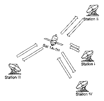
position a satellite cluster with satellites 1A, 1B, 1C,
1D, 1E, 1F, 1G, and 1H is provided. As can be seen from the
measurement result according to Fig. 18, the time
synchronisation error is not correlated between the
stations III and II. However, according to the cognition of
the invention, the time synchronisation error for one
station with regard to different satellites is nearly the
same. This result is shown in Fig. 19.
Fig. 19 shows the measurement of the time synchronisation
error for different receiving stations with regard to two
different satellites. Again referring to Fig. 5, the
satellites 1A and 1B within the same orbit position are
chosen, wherein the ranging error is measured over time for
station III. As it can be seen on the left-hand side, the
ranging errors are. nearly the same, wherein at the right-
38
CA 02442253 2003-09-26
WO 02/079800 PCT/EP02/00350
hand side the difference between both measurements is
shown.
The result of Fig. 19 is the.following: If one knows the
position of one of the two satellites, let say the
satellite 1B, it is possible to derive the synchronisation
error between each receiving station and the transmission
station. Knowing this synchronisation error, the measured
pseudo range data for satellite 1A can be corrected. The
1o resulting arrangement for such a measurement is shown in
Fig. 20.
Fig. 20 shows the basic configuration of a pseudo range
measurement with regard to two different satellites. It is
assumed that station I is the master station with a
transmission and a receiving equipment.
On the other hand, the other stations are receiving
stations, wherein merely station III is shown by way of an
2o example. It is assumed that the position of the satellite
1A is known at the location of station I. The pseudo range
measurement by the receiving station III is then performed
by the following steps:
In a first step, two predetermined signal patterns are
transmitted from the station I via the satellites 1A and 2A
to the receiving station III. In a next step, the receiving
station III transmits the propagation time data on the
basis of a pseudo range measurement of orbit 1 and orbit 2
3o to the station I. Since according to the assumption the
range of orbit 1 at the station I is known, a correction
calculation can be carried out as explained according to
Fig. 19. Thereby, the ranging information of the satellite
2A can be calculated and can be corrected by known
synchronization error with reference to the satellite 1A.
39
CA 02442253 2003-09-26
WO 02/079800 PCT/EP02/00350
As a result, a pseudo ranging measurement can be provided
on the basis of an arbitrary common time base with limited
accuracy, wherein the common time base is corrected by the
reference ranging information of the referen.~e satellite
1A. Thereby, a GPS-independent pseudo ranging system can be
built up.
Fig. 21 shows the processing equipment for one receiving
station of the basic configuration according to Fig. 18. As
1o it can be seen, the receiving equipment can be built up
very simply which leads to an inexpensive structure of the
receiving stations. Each receiving station comprises two
similar receiving arrangements comprising an LNB 2101, 2104
connected to receiving antennas 2107, 2108, a down-
converter 2102, 2105 and a demodulator 2103, 2106. The
components are controlled by a frequency and timing device
2109, which comprises also a common data base, e.g. a
simple GPS receiver. The data are collected in a data
collection unit 2110 for determining the propagation time
2o data of orbit 1 and orbit 2.