Note: Descriptions are shown in the official language in which they were submitted.
CA 02470305 2004-06-08
f
1
WELL TWINNING TECI~INIQUES
IN BOREHOLE SURVEYI1~TG
The present invention relates generally to surveying a subterranean borehole
to determine,
for example, the path of the borehole. More particularly this invention
relates to a
method of passive ranging to determine directional and/or locational
parameters of a
borehole using sensors including one or more magnetic field measurement
devices.
The use of magnetic field measurement devices (e.g., magnetometers) in prior
art
subterranean surveying techniques for determining the direction of the earth's
magnetic
field at a particular point is well known. The use of accelerometers or
gyroscopes in
combination with one or more magnetometers to determine direction is also
known.
Deployments of such sensor sets are well known to determine borehole
characteristics
such as inclination, azimuth, positions in space, tool face rotation, magnetic
tool face, and
magnetic azimuth (i.e., an azimuth value determined from magnetic field
measurements).
While magnetometers are known to provide valuable information to the surveyox,
their
use in borehole surveying, and in particular measurement while drilling (MWD)
applications, tends to be limited by various factors. For example, magnetic
interference,
such as from the magnetic steel components (e.g., liners, casings, etc.) of an
adjacent
borehole (also referred to as a target well herein) tends to interfere with
the earth's
magnetic field and thus may cause a deflection in the azimuth values obtained
from a
magnetometer set.
CA 02470305 2004-06-08
2
Passive ranging techniques may utilize such magnetic intei~ferenee fields, for
example, to
help determine the location of an adjacent well (target well) to reduce the
risk of collision
and/or to place the well into a kill zone (e.g., near a well blow out where
formation fluid
is escaping to an adjacent well). U.S. Patent 5,675,488 and U.S. Patent
Applications
10/368,257, 10/368,742, and 10/369,353 to McElhinney (herein referred to as
the
McElhinney patents) describe methods for determining the position of a target
well with
respect to a measured well (e.g., the well being drilled) in close proximity
thereto. Such
methods utilize three-dimensional magnetic interference vectors determined at
a number
of points in the measured well to determine azimuth and/or inclination of the
target well
and/or the distance from the measured well to the target well.
The methods described in the McElhinney patents have been shown to work well
in a
number of borehole surveying applications, such as, for example, well
avoidance and or
well kill applications. However, there remain certain other applications for
which
improved passive ranging techniques may advantageously b~e utilized. For
example, well
twinning applications (in particular in near horizontal well se;ctions), in
which a measured
well is drilled essentially parallel to a target well, may benefit from such
improved
passive ranging techniques. Therefore, there exists a need for improved
borehole
surveying methods utilizing various passive ranging techniques.
Exemplary aspects of the present invention are intended to address the above
described
need for improved surveying methods utilizing various passive ranging
techniques.
Referring briefly to the accompanying figures, aspects of this invention
include methods
for surveying a borehole. Such methods make use of magnetic flux emanating
from
nearby magnetized subterranean structures (typically referred to herein as
target wells),
CA 02470305 2004-06-08
3
such as cased boreholes. Such magnetic flux may be passively measured to
determine a
direction and distance from the borehole being surveyed (also referred to
herein as the
measured well) to the target well. In various exemplary embodiments, the
orientation of
the measured well relative to the target well, the absolute coordinates, and
the azimuth of
the measured well may also be determined.
Exemplary embodiments of the present invention advantageously provide several
technical advantages. For example, the direction and distance from a measured
well to a
target well may advantageously be determined without having to reposition the
downhole
tool in the measured well. Further, embodiments of this invention may be
utilized to
determine an azimuth value of the measured well. Such azimuth determination
may be
advantageous in certain drilling applications, such as in regions of magnetic
interference
where magnetic azimuth readings are often unreliable. Aspects of this
invention may also
advantageously be utilized in certain drilling applications, such as well
twinning and/or
relief well applications, to guide continued drilling of the measured well,
for example, in
a direction substantially parallel with the target well.
In one aspect the present invention includes a method for surveying a
borehole. The
method includes providing a downhole tool including first and second magnetic
field
measurement devices disposed at corresponding first and second positions in
the
borehole. The first and second positions are selected to be within sensor
range of
magnetic flux from a target subterranean structure. The method further
includes
measuring total local magnetic fields at the first and second positions using
the
corresponding first and second magnetic field measurement devices, processing
the total
local magnetic fields at the first and second positions and a reference
magnetic field to
CA 02470305 2004-06-08
t
4
determine a portion of the total local magnetic fields attributable to the
target
subterranean structure, and generating interference magnetic field vectors at
the first and
second positions from the portion of the total local magnetic field
attributable to the target
subterranean structure. The method further includes processing the
interference magnetic
field vectors to determine tool face to target angles at each of the first and
second
positions. One variation of this aspect further includes providing a
historical survey of at
least a portion of the target subterranean structure and processing the tool
face to target
values at the first and second positions and the historical survey to
determine a distance
from the borehole to the target subterranean structure. Another variation of
this aspect
includes processing the distance and the historical survey to determine a
location of either
the first or second positions and utilizing the location to determine a
borehole azimuth.
'The foregoing has outlined rather broadly the features and technical
advantages of the
present invention in order that the detailed description of the invention that
follows may
be better understood. Additional features and advantages of the invention will
be
described hereinafter which form the subject of the claims of the invention.
It should be
appreciated by those skilled in the art that the conception and the specific
embodiment
disclosed may be readily utilized as a basis for modifying or designing other
structures for
carrying out the same purposes of the present invention. It should be also be
realize by
those skilled in the art that such equivalent constructions do not depart from
the spirit and
scope of the invention as set forth in the appended claims.
For a more complete understanding of the present invention, and the advantages
thereof,
reference is now made to the following descriptions taken in conjunction with
the
accompanying drawings, in which:
CA 02470305 2004-06-08
FIGURE 1 is a schematic representation of an exemplary embodiment of a MWD
tool
according to the present invention including both upper and. lower sensor
sets.
5 FIGURE 2 is a diagrammatic representation of a portion of the MWD tool of
FIGURE 1
showing unit magnetic field and gravity vectors.
FIGURES 3A and 3B are schematic representations of an exemplary application of
this
invention.
FIGURE 4 is a schematic representation of a cross sectional view along section
4-4 of
FIGURE 3B.
FIGURE 5 is a schematic representation of a hypothetical plot of tool face to
target versus
well depth as an illustrative example of one embodiment of this invention.
FIGURE 6 depicts a cross sectional view similar to that of FIGURE 4 as an
illustrative
example of various embodiments of this invention.
FIGURES 7A and 7B depict cross sectional views similar to those of FIGURES 4
and 6
as illustrative examples of other embodiments of this invention.
FIGURE 8 is a graphical representation of tool face to target versus measured
depth,
similar to the hypothetical plot of FIGURE 5, for a portion of an exemplary
borehole
survey conducted according to exemplary embodiments of this invention.
CA 02470305 2004-06-08
6
FIGURE 9 is a graphical representation of azimuth and distance versus measured
depth
for another portion of the survey shown in FIGURE 8.
FIGURE 10 is a graphical representation of tool face to target versus
measurement
number for a portion of a field test conducted according to exemplary
embodiments of
this invention.
FIGURE 11 is a graphical representation of tool face to target and the dip of
the magnetic
interference vector versus measurement number for the field test shown in
FIGURE 10.
FIGURE 12 depicts a cross sectional view similar to that of FIGURES 4, 6, 7A
and 7B as
an illustrative example of still other exemplary embodiments of this
invention.
FIGURE 13 is a display of a drilling plan for a hypothetical well twinning
operation.
FIGURE 14 is another diagrammatic representation of a portion of the MWD tool
of
FIGURE 1 showing the change in azimuth between the upper and lower sensor
sets.
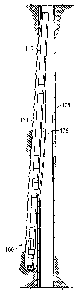
Refernng now to FIGURE l, one exemplary embodiment of a downhole tool 100
useful
in conjunction with the method of the present invention is illustrated. In
FIGURE 1,
downhole tool 100 is illustrated as a measurement while drilling (MWD) tool
including
upper 110 and lower 120 sensor sets coupled to a bottom hole assembly (BHA)
150
including, for example, a steering tool 154 and a drill bit assembly 158. The
upper 110
and lower 120 sensor sets are disposed at a known spacing, .for example, on
the order of
from about 2 to about 20 meters (i.e., about 6 to about 60 feet). Each sensor
set (110 and
CA 02470305 2004-06-08
7
120) includes at least two (and preferably three) mutually orthogonal magnetic
field
sensors, with at least one magnetic field sensor in each set having a known
orientation
with respect to the borehole, and three mutually orthogonal gravity sensors.
It will be
appreciated that the method of this invention may also be practiced with a
downhole tool
including only a single sensor set having at least two magnetic field sensors.
Referring now to FIGURE 2, a diagrammatic representation of a portion of the
MWD
tool of FIGURE 1 is illustrated. In the embodiment shown on FIGURES 1 and 2,
each
sensor set includes three mutually perpendicular magnetic field sensors, one
of which is
oriented substantially parallel with the borehole and measures magnetic field
vectors
denoted as Bzl and Bz2 for the upper 110 and lower 120 sensor sets,
respectively. The
upper 110 and lower 120 sensor sets are linked by a structure 140 (e.g., a
semi-rigid tube
such as a portion of a drill string) that permits bending along its
longitudinal axis 50, but
substantially resists rotation between the upper 110 and lower 120 sensor sets
along the
longitudinal axis 50. Each set of magnetic field sensors thus may be
considered as
determining a plane (Bx and By) and pole (Bz) as shown. As described in more
detail
below, embodiments of this invention typically only require magnetic field
measurements
in the plane of the tool face (Bx and By as shown in FIGURE 2 which
corresponds with
plane 121, for example, in sensor set 120). The structure 140 between the
upper 110 and
lower 120 sensor sets may advantageously be part of, for example, a MWD tool
as shown
above in FIGURE 1. Alternatively, structure 140 may be a part of substantially
any other
logging andlor surveying apparatuses, such as a wireline surveying tool.
As described above, embodiments of this invention may be particularly useful,
for
example, in well twinning applications (e.g., relief well drilling), such as
that shown in
CA 02470305 2004-06-08
8
FIGURES 3A and 3B. Generally speaking twinning refers to applications in which
one
well is drilled in close proximity (e.g., parallel) to another well for
various purposes.
Relief well drilling generally refers to an operation in which one will is
drilled to
intercept another well (e.g., to prevent a blow). Nevertheless, the terms
twinning and
relief well will be used synonymously and interchangeably in this disclosure.
In FIGURE
3A, a bottom hole assembly 1 SO is kicked off out of a casing window 178 in a
pre-
existing borehole 175. "Kicking ofd' refers to a quick change in the angle of
a borehole,
and may be associated, for example with drilling a new hole from the bottom or
the side
of an existing borehole. A relief well 177, for example, is then drilled
substantially
parallel with the pre-existing borehole 175, as shown in FIGURE 3B. In such
applications there tends to be significant magnetic interference emanating
from the pre
existing borehole 175, e.g., from the well casing, owing, for example, to
residual
magnetization from magnetic particle inspection procedures. Normally, such
magnetic
interference fades (decreases) quickly as the distance to the pre-existing
borehole
increases. However, in relief well applications, for example, in which the
distance
between the relief well 177 and the pre-existing borehole 17S typically
remains small
(e.g., from about 1 to about 10 feet}, such magnetic interference tends to
significantly
interfere with the determination of borehole azimuth using conventional
magnetic
surveying techniques. Further, such relief well drilling applications are
often carried out
in near horizontal wells (e.g., to divert around a portion of a pre-existing
borehole that is
blocked or has collapsed). Thus conventional gyroscope and gravity azimuth
surveying
methods may be less than optimal for borehole surveying in such applications.
As
described in more detail below, this invention looks to the magnetic
interference from a
target well (e.g., pre-existing borehole 175) to determine the azimuth of the
measured
well (e.g., relief well 177). Surveying according to the present invention may
thus be
CA 02470305 2004-06-08
9
useful in such relief well andlor well twinning applications. Other exemplary
applications may include, but are not limited to, river crossings in which an
existing well
is followed around various obstacles, re-entry and/or well kill applications,
well
avoidance applications, and substantially any application in which multiple
substantially
parallel wells are desirable (such as also useful in mineral extraction and
ground freeze
applications).
It should be noted that the magnetic interference may emanate from
substantially any
point or points on the target well. It may also have substantially any field
strength and be
oriented at substantially any angle to the target well, with the field
strength at a particular
location generally decreasing with distance from the target borehole. Further,
the
magnetic interference tends to be caused by the tubular elements in the target
well, e.g.,
the casing, drill string, collars, and the like. The magnetic interference
surrounding these
elements is determined by the magnetism (both induced and permanent) in the
metal.
The shape of the interference pattern is particularly influenced by the
homogeneity of the
magnetism and the shape of the metal element. Typically, the magnetism is
substantially
homogeneous and the shape rotationally symmetrical and t~.~bular. Objects in a
borehole,
such as pipe secrions and the like, are often threadably coupled to form a
substantially
continuous cylinder. Thus, the origin of any magnetic interference emanating
from a
borehole may generally be considered to originate in cylinders therefrom. The
magnetic
field emanating from such a borehole (target well) is typically caused by such
cylinders in
a manner typically displayed by cylindrical magnets. Such is the basis for the
passive
ranging techniques disclosed in the McElhinney patents.
CA 02470305 2004-06-08
The magnetic interference may be measured as a vector whose orientation
depends on the
location of the measurement point within the magnetic field. In order to
determine the
magnetic interference vector at any point downhole, the magnetic field of the
earth must
be subtracted from the measured magnetic field vector. T'he magnetic field of
the earth
5 (including both magnitude and direction components) is typically known, for
example,
from previous geological survey data. However, for some applications it may be
advantageous to measure the magnetic field in real time on site at a location
substantially
free from magnetic interference, e.g., at the suxface of the well or in a
previously drilled
well. Measurement of the magnetic field in real time is generally advantageous
in that in
10 that it accounts fox time dependent variations in tlae earth's magnetic
field, e.g., as caused
by solar winds. However, at certain sites, such as on an offshore drilling
rig,
measurement of the earth's magnetic field in real time may not be possible. In
such
instances, it may be preferable to utilize previous geological survey data in
combination
with suitable interpolation and/or mathematical modeling (i.e., computer
modeling)
I S routines.
The earth's magnetic field at the tool may be expressed as follows:
MEx =HE(cosDsinAzcosR+cosDcosAzcoslncsinR-sinDsinlncsinR)
MEY = HE (cos D cos Az cos Inc cos R + sin D sin Inc cos R - cos D sin Az sin
R)
M~Z = HE (sin D cos Inc - cos D cos Az sinlnc) Equation 1
where Mex, Mey, and Mez represent the x, y, and z components, respectively, of
the
earth's magnetic field as measured at the downhole tool, where the z component
is
aligned with the borehole axis, He is known (or measured as described above)
and
represents the magnitude of the earth's magnetic field, and D, which is also
known (or
CA 02470305 2004-06-08
11
measured), represents the local magnetic dip. Inc, Az, and R, represent the
Inclination,
Azimuth and Rotation (also known as the gravity tool face), respectively, of
the tool,
which may be obtained, for example, from conventional gravity surveying
techniques.
However, as described above, in various relief well applications, such as in
near
horizontal wells, azimuth determination from conventional surveying techniques
tends to
be unreliable. In such applications, since the measured borehole and the
target borehole
are essentially parallel (i.e., within a five or ten degrees of being
parallel), Az values from
the target well, as determined, for example in a historical survey, may be
utilized.
The magnetic interference vectors may then be represented as follows:
~Ix = ~x -~sx
~IY ~ $Y MEY
BIZ = Bz -MEZ Equation 2
where Mix, Miy, and Miz represent the x, y, and z components, respectively, of
the magnetic interference vectar and Bx, By, and Bz, as described above,
represent the
measured magnetic field vectors in the x, y, and z directions, respectively.
The artisan of ordinary skill will readily recognize that i.n determining the
magnetic
interference vectors it may also be necessary to subtract other magnetic field
components,
such as drill string and/or motor interference from the borehole being
drilled, from the
measured magnetic field vectors. Techniques for accounting for such other
magnetic
field components are well known in the art.
CA 02470305 2004-06-08
i
12
Referring now to FIGURES 4 through 13, embodiments of the method of this
invention
are described in further detail. With reference to FIGURE 4, a crass section
as shawn on
FIGURE 3B is depicted looking down the target borehole 175. Since the measured
borehole and the target borehole are approximately parallel" the view of
FIGURE 4 is also
essentially looking dawn the measured borehole. The magnetic flux lines 202
emanating
from the target borehole 175 are shown to substantially intersect the target
borehole 175
at a point T. Thus a magnetic field vector 205 determined at the measured
borehole 177,
for example, as determined by Equations 1 and 2 above, provides a direction
from the
measured borehole to the target borehole 175. Since the measured borehole and
the target
borehole are typically essentially parallel, determination of a two-
dimensional magnetic
field vector (e.g., in the planes of the tool faces 111 and 121 shown in
FIGURE 2) and a
two-dimensional interference vector is advantageously sufficient for
determining the
direction from the measured well to the target well. Two-dimensional magnetic
field and
interference vectors may be determined according to Equations 1 and 2 by
solving for
Mex, Mey, Mix, and Miy. As such measurement of the magnetic field in two
dimensions
(e.g., Bx and By) may likewise be sufficient for determining the direction
from the
measured well to the target well. Nevertheless, for certain applications it
may be
preferable to measure the magnetic field in three dimensions.
A tool face to target (TFT) value (also referred to herein as a tool face to
target angle)
may be determined from the magnetic interference vectors given in Equation 2
as
follows:
TAT = arctan(M'~ ) + arctan(Gx) Equation 3
Mrr GY
CA 02470305 2004-06-08
13
where TFT represents a tool face to target direction (angulax orientation),
Mix and Miy
represent the x and y components, respectively, of the magr.~etic interference
vector, and
Gx and Gy represent x and y components of the measured gravitational field
(e.g., gravity
vectors measured at at least one of the first and second sensor sets 110, 120
in FIGURE
S 2). As shown in FIGURE 4, the TFT indicates the direction from the measured
well 177
to the target well 175. For example, a TFT of 90 degreea, as shown in FIGURE
4,
indicates that the target well 175 is directly to the right of the measured
well 177. A TFT
of 270 degrees, on the other hand, indicates that the target well is directly
to the left of the
measured well. Further, at TFT values of 0 and 180 degrees the target well 175
is directly
above and directly below, respectively, the measured well 177. It will be
appreciated that
in certain applications, Equation 3 does not fully define the direction from
the measured
well 177 to the target well 175. Thus in such applications, prior knowledge
regarding the
general direction from the measured well to the target well (e.g., upwards,
downwards,
left, or right) may be utilized in combination with the TFT values determined
in Equation
3. Alternatively, changes in the TFT values between adjacent survey points may
be
utilized to provide further indication of the direction from tlhe measured
well 177 to the
target well 175.
In certain applications, determination of the TFT at two or more points along
the
measured well bore may be sufficient to guide continued drilling of the
measured well,
for example, in a direction substantially parallel with the target well. This
is shown
schematically in FIGURE 5, which plots 250 TFT 252 versus Well Depth 254. Data
sets
262, 264, 266, and 268 represent TFT values determined at'. various well
depths. Each
data set, e.g., data set 262, includes two data points, A and B, determined at
a single
survey location (station). In data set 262, for example, dal:a point A is the
TFT value
CA 02470305 2004-06-08
14
determined from the magnetic interference vector measured at an upper sensor
set (e.g.,
sensor set 110 in FIGURES 1 through 3B) and data point B is the TFT value
determined
from the magnetic interference vector measured at a lower sensor set (e.g.,
sensor set 120
in FIGURES 1 through 3B), which resides some fixed distance (e.g., from about
6 to
about 60 feet) further down the borehole than the upper sensor set. Thus at
each survey
station (data sets 262, 264, 266, and 268) two magnetic iinterference vectors
may be
determined. The TFT at each data point indicates the direction to the target
borehole
from that point on the measured borehole. Additionally, and advantageously for
MWD
embodiments including two sensor sets, comparison of the A. and B data points
at a given
survey station (e.g., set 262) indicates the relative direction of drilling
with respect to the
target well at the location of that survey station. Further, since a drill bit
is typically a
known distance below the lower sensor set, the TFT at the drill bit may be
determined by
extrapolating the TFT values from the upper and lower sensor sets (points A
and B on
FIGURE S).
With continued reference to FIGURE 5, data sets 262, 264, 266, and 268 are
described in
more detail. In this hypothetical example, data sets 262, 264, 266, and 268
represent
sequential survey stations (locations) during an MWD drilling operation and
thus may be
spaced at a known interval (e.g., about 50 feet) in the measured well. At data
set 262, the
target well is down and to the right of the measured well as indicated by the
TFT values.
Since the TFT at point B is closer to 90 degrees than that of point A, data
set 262
indicates that the measured well is pointing downward relative to the target
well. For a
drilling operation in which it is intended to drill the measured well parallel
and at the
same vertical depth as the target well (e.g., at a TFT of 90 degrees), data
set 262 would
indicate that drilling should continue for a time in approxirriately the same
direction. At
CA 02470305 2004-06-08
data set 264, the measured well has moved below the target well as indicated
by TFT
values below 90 degrees. Similar TFT values for points A and B indicate that
the
measured MWD tool (and therefore the measured well) is pointed horizontally
relative to
the target well. At data set 266, the measured well remains below the target
well, but is
5 pointing upward relative thereto. And at data set 268, the measured well is
at about the
same vertical depth as the target well and substantially aligned therewith
vertically.
While tool face to target values determined from the magnetic interference
vectors
provide potentially valuable directional information relating 1:o the position
of a measured
10 well relative to a target well, they do not, alone, provide an indication
of the distance
from the measured well to the target well. According to one aspect of this
invention, the
TFT values may be utilized, along with survey data from the measured well
(e.g.,
inclination values) and historical survey data from the target well, to
determine a distance
from the measured well to the target well. In one variation. of this aspect,
the direction
15 and distance from the measured well to the target well may then be utilized
to determine
absolute coordinates and azimuth values for the measured well at various
points along the
length thereof.
With reference now to FIGURE 6, a view down the target borehole, similar to
that of
FIGURE 4, is shown. It will be appreciated that for near horizontal wells, the
x and y
directions in FIGURE 6 correspond essentially to horizontal and vertical
directions
relative to the target well 175. At first and second survey points 177, 177'
(e.g., as
measured at sensor sets 110 and 120, respectively, as shown in FIGURES 1
through 3B)
the measured borehole is generally downward and to the left of target borehole
175, as
shown. As described above, this is indicated by the TFT values TFT1, TFT2 at
the two
CA 02470305 2004-06-08
16
survey points being less than 90 degrees. In the general case illustrated in
FIGURE 6, the
measured well 177, 177' is not precisely parallel with the tavrget well 175.
As such, the
relative position of the measured well with respect to the target well 175 (in
the view of
FIGURE 6) is a function of the measured depth of the measured well (as shown
by the
relative change in position between the two wells at the first and second
survey points
177, 177'). Such a change in the relative position at the first and second
survey points
177, 177' is represented by ~x and ~y in FIGURE 6, where Bx represents the
relative
change in horizontal position between the first and second survey points 177,
177' of the
measured well and corresponding points on the target well 175 (e.g.,
substantially
orthogonal to the longitudinal axis of the measured well at: the first and
second survey
points), and Dy represents the relative change in vertical position between
the first and
second survey points 177, 177' of the measured well and corresponding points
on the
target well 175. As described above, in many instances the: relative change in
positions
between the two wells (as defined by ~x and ~y) results in a change in the
measured tool
face to target value, ~TFT, between the first and second survey points 177,
177'. As
described in greater detail below, for certain applications, the distances dl
and d2 from
the first and second survey points 177, 177' on the measured well to the
target well 175
are approximately inversely proportional to BTFT.
It will be appreciated that based on FIGURE 6 and known trigonometric
principles, the
distances dl and d2 may be determined mathematically, for example, from Ox,
~y, TFT1
and TFT2. With continued reference to FIGURE 6, and according to the
Pythagorean
Theorem, distances dl and d2 may be expressed mathematically as follows:
dI=.Jx2+(Y-DY)2
CA 02470305 2004-06-08
17
d 2 = ~(x - fix) 2 + y Z Equation 4
where x and y represent the horizontal distance from the first survey point
177 to the
target well 175 and the vertical distance from the second survey point 177' to
the target
well 175, respectively. x and y may be expressed mathematically as follows:
- ~1x tan(TFT 1) - 0y tan(TFT 1) tan(TFT2)
x=
tan(TFT 2) - tan(TFT 1)
_ - ~y tan(TFT 1) - ~
y tan(TFT 2) - tan(TFT 1) Equation 5
where, as described above, ~x represents the relative change in horizontal
position
between the first and second survey points 177, 177' of the measured well and
corresponding points on the target well 175, ~y represents the relative change
in the
vertical position between the first and second survey points 177, 177' on the
measured
well and corresponding points on the target well 175, and TFT1 and TFT2
represent the
tool face to target values at the first and second survey pointy 177, 177',
respectively. As
described in greater detail below, Ox and Dy may be determined, for example,
from
azimuth and inclination measurements of the measured and target wells.
Distances dl and d2 may alternatively be expressed mathematically as follows:
- ~ - ~y tan(TFT 2)
dl =
cos(TFTl)[tan(TFT2) - tan(TF'Tl)]
- Ox - ~y tan(TFT 1) Eq~tion 6
d 2 = cos(TFT 2)[tan(TFT 2) - tan(TFT 1)]
where dl, d2, fix, TFTI, and TFT2 are defined above.
CA 02470305 2004-06-08
18
As shown below in more detail, Ox and ~y may be determined from azimuth and
inclination values, respectively, of the measured and targf;t wells. For some
drilling
applications in which embodiments of this invention are suitable, magnetic
interference
tends to interfere with the determination of azimuth values of the measured
well using
conventional magnetic surveying techniques. In such appliications
determination of Ox
may be problematic. Thus, in certain applications, it may be advantageous to
determine
the distances dl and d2 independent from Ox (and therefore: independent of the
azimuth
values of the measured and target wells).
In various applications, such as common well twinning and relief well drilling
applications, the intent of the drilling operation is to position the measured
well
substantially parallel and side by side with the target well 1'75. As
described above, the
measured TFT values for such applications are approximately 90 or 270 degrees
(e.g.,
within about 45 degrees thereo f . It will be appreciated that in such
applications relative
changes in the horizontal position between the measured and target wells, 0x,
typically
has a minimal effect on the measured TFT values (i.e., resulta in a relatively
small BTFT
value for a given 0x). As such, for many applications, determination of the
distances dl
and d2 from survey points 177, 177' of the measured well to corresponding
points on the
target well 175 may be derived considering only relative changes in the
vertical position,
Dy, between the measured and target wells.
With reference now to FIGURE 7A, distances dl and d2 may be expressed
mathematically with respect to By, TFT1, and TFT2 as follows:
d 1= - ~Y tan(TFT 2)
cos(TFTI)[tan(TFT2) - tan(TF~!'1)]
CA 02470305 2004-06-08
19
d 2 = - ~Y ~n(TFT 1) Equation 7
cos{TFT 2)[tan(TFT 2) - tan(T,FT 1)]
where, as described above, dl and d2 represent the distances from the measured
well to
the target well at the first and second survey points 177, 177', respectively,
TFT1 and
TFT2 represent the tool face to target values at the first and second survey
points 177,
177', respectively, and Dy represents the relative change in vertical position
between the
first and second survey points 177, 177' of the measured well and
corresponding points
on the target well.
Turning now to FIGURE 7B, for certain applications (e.g., when a measured well
is
drilled substantially side by side with a target well), the tool face to
target value may be
assumed to be approximately equal to 90 or 270 degrees. Based on such an
assumption,
the distances dl and d2 may alternatively be expressed mathematically as
follows:
dl = ~Y
tan( TFT)
d 2 = ~Y Equation 8
sin(~TFT )
where, as stated above, ~TFT is the difference between the tool face to target
values at
the first and second survey points 177, 177'. At relatively small 0'FFT values
(e.g., when
aTFT is less than about 30 degrees), the distances dl and d2 may alternatively
be
expressed mathematically as follows:
d l ~ d 2 ~ ~Y Equation 9
~TFT
CA 02470305 2004-06-08
where ~TFT is in units of radians.
Equation 9 advantageously describes distance (dl and d2) firom the measured
well to the
target well 175 as being substantially proportional to ~y and as substantially
inversely
5 proportional to the change in tool face to target value C~TFT. While not
generally
applicable to all well drilling applications (or even to all twinning
applications), Equation
9 may be valuable for many applications in that it provides relatively simple
operational
guidance regarding the distance from the measured well to the target well. For
example,
in certain applications, if the change in tool face to target value ~TFT
between two
10 survey points is relatively small (e.g., less than about 5 degrees or 0.1
radians) then the
distance to the target well is at Ieast an order of magnitude greater than ~y
(e.g., dl and
d2 are about a factor of 10 greater than ~y when ~TFT is about 5 degrees or
0.1 radians).
Conversely, if OTFT is relatively large (e.g., about 30 deg~.°ees or
0.5 radians) then the
distance to the target well is only marginally greater than Dy (e.g., dl and
d2 are about a
15 factor of 2 greater than ~y when BTFT is about 30 degrees or 0.5 radians).
With continued reference to FIGURES 7A and 7B, and Equations 7 through 9, it
can be
seen that the distances from the first and second survey points 177, 177' of
the measured
well to corresponding points on the target well are expressed mathematically
as functions
20 of 0y, TFTI and TFT2. As described above, TFTI and TFT2 may be determined
from
magnetic interference emanating from the target well. 11y .rnay typically be
determined
from conventional survey data obtained for the measuxed well and/or from
historical
survey data for the target well. In one exemplary embodiment of this
invention, ~y may
be determined from inclination values at the first and second survey points
177, 177' of
the measured well and corresponding points on the target well. The inclination
values for
CA 02470305 2004-06-08
21
the measured well may be determined via substantially any known method, such
as, for
example, via local gravity measurements, as described in more detail below and
in the
McElhinney patents. The inclination values of the target wf;ll are typically
known from a
historical survey obtained, for example, via gyroscope or other conventional
surveying
methodologies in combination with known interpolation techniques as required.
Such
inclination values may be utilized in conjunction with substantially any known
approach,
such as minimum curvature, radius of curvature, average angle, and balanced
tangential
techniques, to determine the relative change in vertical position between the
two wells,
~y. Using one such technique, Dy may be expressed mathematically as follows:
IncMl + IncM2 IncTl +~ IncT2
Dy = OIITD(sin( 2 - )) Equation 10
where OMD represents the change in measured depth between the first and second
survey
points, IncMl and IncM2 represent inclination values for the measured well at
the first
and second survey points 177, 177', and IncTl and IncT2 represent inclination
values for
the target well at corresponding ftrst and second points.
As described above, for many drilling applications in which embodiments of
this
invention are suitable, magnetic interference from the target well tends to
significantly
interfere with the determination of the azimuth of the measured well using
conventional
magnetic surveying techniques. Further; such drilling applications are often
carried out in
near horizontal wells (e.g., to divert around a portion of a hre-existing
borehole that has
collapsed). Thus conventional gyroscope and gravity azimuth surveying methods
may be
less than optimal for borehole surveying in such applications. As shown above,
in
Equations 7 through 10, the distances dl and d2 from the measured well to the
target well
CA 02470305 2004-06-08
22
may be determined from TFT1, TFT2, and the inclination values at corresponding
points
along the measured and target wells. It will be appreciated that Equations 7
through 10
are advantageously independent of the azimuth values of either the measured or
target
wells. Thus a determination of the azimuth values (or the relative change in
azimuth
values) is not necessary in the determination of distances dl and d2. Further,
as described
in more detail below, the distances dl and d2, along with a historical survey
of the target
well, may be utilized to determine the coordinates of the first and second
survey points
177, 177' and the local azimuth of the measured well.
It will be appreciated that according to Equations 4 through 9, determination
of the
distances dl and d2 requires a relative change in the position of the measured
well with
respect to the target well (e.g., ~x and/or ~y) that results in a measurable
change in the
tool face to target angle (6TFT) between the first and second survey points
177, 177'.
For certain applications in which the measured well closely parallels the
target well it
may be desirable to occasionally deviate the path of the measured well with
respect to the
target well in ordex to achieve significant changes in tool face: to target
angles (e.g., aTFT
on the order of a few degrees or more). Such occasional deviation of the path
of the
measured well may advantageously improve the accuracy of a distance
determination
between the two wells. For example, in an application in which the measured
well is
essentially parallel with the target well at a tool face to target angle of
about 90 degrees
(i.e., the measured well lies to the right of the target well), it may be
desirable to
occasionally deviate the measured well path upwards and then back downwards
with
respect to the target well. Such upward and downward deviation of the measured
well
path may result in measurable ~y and OTFT values that may be advantageously
utilized
to calculate distance values as described above.
CA 02470305 2004-06-08
23
The artisan of ordinary skill will readily recognize that Equations 4 through
10 may be
written in numerous equivalent or similar forms. For example, the definitions
of TFTl
and TFT2 or the signs of Ox and ~y may be modified depending the quadrant in
which
survey points 177 and 177' reside. In addition, the origin in FIGURES 6
through 7B may
be located at one of survey points 177 or 177' rather than at the target well
175. All such
modifications will be understood to be within the scope of this invention.
With the determination of the direction (i.e., TFT or OTFT') and the distance,
dl or d2,
from the measured borehole to the target borehole at various points along the
measured
borehole it is possible to determine the location (i.e., the absolute
coordinates) of those
points on the measured borehole based on historical survey data for the target
well. The
location at survey points 177 and 177' may be given as follows:
PMxI = PTx - d 1 sin(TFT l)
PMyI = PTy - dl cos(TFTI)
PMx2 = PTy - d 2 sin(TFT 2) Equation 11
PMy2 = PTy - d 2 cos(TFT 2)
where PMxI and PMyI, represent x and y coordinates at survey point 177, PMx2
and
PMy2 represent x and y coordinates at survey point 177', PTx and PTy represent
x and y
coordinates of the target well 175, dl and d2 represent distances from survey
points 177,
177' to the target well 175, and TFTl and TFT2 represent tool face to target
values
between the survey points 177 and 177' and the target well 175. It will be
appreciated
that the coordinates determined in Equation 11 are in a coordinate system
looking down
the longitudinal axis of the target well. The artisan of ordinary skill will
readily be able to
convert such coordinates into one or more conventional coordinate systems,
including, for
example, true north, magnetic north, UTM, and other custorr~ coordinates
systems.
CA 02470305 2004-06-08
24
Once the coordinates have been determined at the survey points 177 and 177' in
a
conventional coordinates system, determination of azimuth values for the
measured
borehole may be derived as follows:
Cy2 - Cyl
AzM = arctan( Cx2 - Cxl ) Equation 12
where AzM represents a local azimuth between survey points 177 and 177' and
Cxl, Cx2, Cyl, and Cy2 represent x and y coordinates in a conventional
coordinates
system at survey points 177 and 177', respectively. Inclination values may be
determined, for example, from conventional surveying methodologies, such as
via gravity
sensor measurements (as described in more detail below).
Referring now to Table 1 and FIGURES 8 and 9, exernp:lary methods of the
present
invention are discussed further by way of an actual field test example. An MWD
tool,
similar to that described above with respect to FIGURE 1, was used to guide
drilling of a
relief well essentially parallel with and at about the same vertical depth
(i.e., essentially
side by side) as an existing target well. The target well was essentially
horizontal (having
an inclination greater than 80 degrees) and oriented at an azimuth ranging
from about 168
to about 173 degrees. With reference to Table 1, a portion of an exemplary
survey
conducted at a measured depth ranging from about 16,100 to about 16,600 feet
is
illustrated. At survey points 1 through 10, the gravity and magnetic fields
were measured
at upper and lower sensor sets. The upper sensor set was disposed about 16
feet above
the lower sensor set and the survey points were spaced at about 50 foot
intervals. Tool
face to target (TFT) values were determined from the magnetic interference
vectors at
each survey point. The distances from the measured well i;o the target well
were also
CA 02470305 2004-06-08
measured at various survey points and were utilized to determine absolute
coordinates
and azimuth values at those points on the measured well as slhown. Inclination
values for
the measured well were determined via conventional gravity vector measurements
as in
more detail below.
Survey Sensor Depth TFT Distance InclinationAzimuth
Set ft ft
I 6,144 269 80. 8
1
1 2 I 6,160 279 80.9
1 16,194 246 81. 8 171
2 2 16,210 255 0.6 82.4
I 16,241 256 83.8
3 2 16,257 254 84.4
1 16,290 273 1.1 84.5 172
4 2 16,306 268 1.4 85.2 172
1 16,335 256 3.0 86.7 174
5 2 16,351 255 3.2 87.2 172
I 16,385 269 87.1
6 2 16,401 269 87.3
1 16,429 270 5.0 87.7 172
7 2 16,445 271 88.4
1 16,480 270 88.8
8 2 16,496 266 89.0
1 16,556 238 88.6
9 2 _16,572 253 3.5 88.9 168
I 16,574 242 3.0 88.6 168
~10 2 16,590 253 88.7
5
Table 1
Refernng now to FIGURES 8 and 9, the data in Table 1 is discussed in more
detail.
FIGURE 8 is a plot of tool face to target versus well depth. As described
above, with
10 respect to FIGURE 5, the tool face to target data in FIGURE 8 indicate the
direction from
the measured well to the target well at various points along. the measured
well. As also
described above, the direction in which the measured well is pointing,
relative to the
target well, is indicated at each survey station. For example, at survey
station 2, the
CA 02470305 2004-06-08
26
measured well was positioned above the target well and pointing relatively
downward.
Likewise at survey station 6, the measured well was positioned approximately
level with
the target well and pointing substantially Level therewith.
With reference now to FIGURE 9 the azimuth values of the measured and target
wells
and the distance between those wells are plotted versus measured depth. The
azimuth
values for the target well are shown at 302 and were obtained from a
historical survey of
the target well. The azimuth values for the measured well are shown at 304.
The
distances between the measured and target wells are shown at 306. Table 1
above shows
both the azimuth values for the measured well 304 and the distances 306
between the
measured and target wells. These values were determined according to
embodiments of
this invention. At measured depths from about 16,100 to about 16,250 feet, the
azimuth
values for the measured and target wells were substantially the same,
indicating that the
measured well was closely paralleling the target well (as is desirable for
various relief
well applications). The relatively small distance between the two wells (about
a foot)
further confirms that the measured well was closely paralleling the target
well. At a
measured depth from about 16,300 to about 16,350 feet the azimuth of the
measured well
increased to about three degrees greater than that of the target well (about
174 versus
about 171 degrees), indicating that the measured well was drifting slightly
out of parallel
with the target well. This is confirmed by the increased distance between the
two wells
(up to about five feet at a depth of 16,400 feet). The azimuth of the measured
well was
then corrected, based on the data from this survey, and the distance between
the two wells
reduced to about three feet (at a depth of about 16,600 feet).
CA 02470305 2004-06-08
27
Based on the data shown in this example in Table 1 and FIGURES 8 and 9 it can
be seen
that embodiments of this invention include a method for drilling a relief well
(or a method
for twinning a well) that includes utilizing the surveying techniques
described herein to
guide the drill string (the measured well) along a predetermined course
substantially
parallel with a target well. For example, as described above, an operator may
utilize plots
of tool face to target values versus well depth to adjust th.e vertical
component of the
drilling direction. Likewise a comparison of the azimuth values for the
measured and
target wells may be utilized to adjust the azimuthal (lateral) component of
the drilling
direction. Such a procedure enables the position of a measured well to be
determined
relative to the target well in substantially real time, thereby enabling the
drilling direction
to be adjusted to more closely parallel the target well.
In determining the magnetic interference vectors, tool face to target values,
the distance
between the measured and target wells, and the azimuth of the measured well,
it may be
advantageous in certain applications to employ one or more techniques to
minimize or
eliminate the effect of erroneous data. Several options are available. For
example, it may
be advantageous to apply statistical methods to eliminate outlying points, for
example,
removing points that are greater than some predetermined deviation away from a
previously measured point. Thus for example, if the distance between two wells
is 3 feet
at a first survey point, a distance of 23 feet may be rejected at a second
survey point. In
certain instances it may also be desirable to remove individual interference
vectors from
the above analysis. For example, an interference vector may be removed when
the
magnitude of the interference magnetic field vector is less than some minimum
threshold
(e.g., 0.001 Gauss).
_ _________~___~._._.~. . ____. _ ___..., _ __ .._
CA 02470305 2004-06-08
28
An alternative, and also optional, technique for minimizing error and reducing
the effect
of erroneous data is to make multiple magnetic field measurements at each
survey station.
For example, magnetic field measurements may be made a.t multiple tool face
settings
(e.g., at 0, 90, 180, and 270 degrees) at each survey station in the measured
well bore.
Such rotation of the tool face, while effecting the individual magnetometer
readings (i.e.,
Bx and By), does not effect the interference magnetic field., the tool face to
target, the
distance between the two wells, or the azimuth of the measured well.
Referring now to FIGURE 10, a plot of tool face to target versus measurement
number is
shown for a field test in which a section of magnetized casing was placed
substantially
horizontally on the ground as a hypothetical target well. A. hypothetical
measured well
was disposed nearby at a known position and orientation relative to the
casing. A single
set of magnetometers was utilized to measure the magnetic field at points
(stations) along
the hypothetical measured well. Magnetic interference vectors and tool face to
target
values were determined at each point as described above. A.t numerous points,
the set of
magnetometers was rotated to four distinct orientations (0, 90, 180, and 270
degrees) as
described above. The tool face to target values determined via embodiments of
this
invention were compared to hand measured values. FIGURE 10 shows excellent
agreement between the tool face to target values determined via embodiments of
the
passive ranging techniques of this invention and the hand measured values.
FIGURE 10 further shows, in this particular example, that ai; intermediate
distances (e.g.,
from about 2 to about 20 feet shown in measurement points 10 through 50),
highly
accurate tool face to target values may be obtained from a measurement of the
magnetic
field at a single tool face setting. At very small distances (less than about
1 or 2 feet
CA 02470305 2004-06-08
29
shown in measurement points 1 through 9) or large distances (greater than
about 20 feet
shown in measurement points 50 through 60), data averaging via rotation of the
tool face,
while not necessary, may improve tool face to target accuracy. Such improved
accuracy
may be advantageous for certain applications in which the position of a relief
well must
be known with a relatively high degree of accuracy.
Erroneous data may also optionally be identified by comparing the dip of the
magnetic
interference vectors with the tool face to target (TFT) values as shown in
FIGURE 11.
The dip of the magnetic interference vector is theoretically less than or
about equal to the
TFT. Thus, survey points at which the dip of the magnetic interference vector
is greater
than the TFT may possibly be erroneous. FIGURE 11 plots TFT and the dip of the
magnetic interference vector versus the measurement number for the field test
data shown
in FIGURE 10. As shown, the dip values are less than the TFT values except for
a few
measurement points (a portion of measurement points 50 through 60) at which
the
1 S distance between the hypothetical measured and target wells is large
(greater than about
feet) and the corresponding magnetic interference ve<;tor is weak (less than
0.02
Gauss). Such a large distance and weak magnetic interference field may, in
some
instances, introduce error into the TFT values.
20 With reference again to FIGURE 6 and Equations 4 and 5, it was shown above
that the
distances dl and d2 between the first and second survey points 177, 177' on
the measured
well and corresponding points on the target well 17S may be expressed
mathematically as
a function of the tool face to target values TFT1 and TFT2 and the relative
changes in the
horizontal ~x and vertical 0y positions between the first and second survey
points 177,
2S 177' on the measured well and corresponding points on the target well 175.
With
.._.. e.....~.~...~.," F ~.r ,~~.._ ...
CA 02470305 2004-06-08
reference again to FIGURES 7A and 7B and Equations 6 through 8, it was shown
that for
certain applications in which TFTl and TFT2 are about 90 or 270 degrees (e.g.,
within
about 45 degrees thereof) distances dl and d2 may alternatively be expressed
mathematically as a function of 0y, TFTI, and TFT2 (i.e., substantially
independent of
5 fix). As described above, such an alternative approach advantageously
enables dl and d2
to be determined based on the measured TFT values (TFTI. and TFT2) and
inclination
values for the measured and target wells (i.e., independent of azimuth values
which are
sometimes unreliable in regions of magnetic interference). However, it should
be noted
that this alternative approach is not necessarily suitable for all drilling
applications.
10 Rather, for some applications determination of the distances dl and d2 may
require
knowledge of ~x as described in Equations 4 and 5 and shown in FIGURE 6.
As described above, both Ox and ~y may be determined from conventional survey
data
obtained for the measured well and historical survey data for the target well.
While ~y
15 may be determined from inclination values, as shown in Equation 10, 0x may
be
determined from azimuth values at the first and second survey points 177, 177'
of the
measured well and corresponding points on the target well. The azimuth values
for the
measured well may be determined via substantially any known method, such as,
for
example, via gravity MWD measurements, as described in more detail below and
in the
20 McElhinney patents. Azimuth values of the target well are typically known
from a
historical survey obtained, for example, via gyroscope or other conventional
surveying
methodologies in combination with known interpolation techniques as required.
Such
azimuth values may be utilized in conjunction with substantially any known
approach,
such as minimum curvature, radius of curvature, average angle, and balanced
tangential
_.._... __ _.._...._~_,..,~~.e.~,,W",..~
~.~R~,"..roo~~.~....-. _..... _ _._.
CA 02470305 2004-06-08
31
techniques, to determine the relative change in horizontal position between
the two wells,
~. Using one such technique, t1x may be expressed mathematically as follows:
~x = ~1MD(sin(AziMl 2 AziM2 - AziTl 2 AziT2)) Equation 13
where OMD represents the change in measured depth between the first and second
survey
points, AziMl and AziM2 represent azimuth values for the measured well at the
first and
second survey points 177, 177', and AziTl and AziT2 represent azimuth values
for the
target well at corresponding first and second points.
In certain of the above applications, the intent of the drilling operation may
be to position
the measured well substantially above or below the target well 175 (FIGURE 6)
or to pass
over or under the target well 175. As described above, the measured TFT values
for such
applications are approximately 0 or 180 degrees (e.g., within about 45 degrees
thereof). It
will be appreciated that in such applications relative changea in the vertical
position, dy,
1 S between the measured and target wells typically has a minimal effect on
the measured
TFT values (i.e., results in a relatively small ~TFT value for a given Dy). As
such, for
these applications, determination of the distances dl and d2 from survey
points 177, 177'
of the measured well to corresponding points on the target well 175 may be
derived
considering only relative changes in the horizontal position, Ox, between the
measured
and target wells.
With reference now to FIGURE 12, distances dl and dl may be expressed
mathematically with respect to tlx, TFT1, and TFT2 as follows:
CA 02470305 2004-06-08
32
dl =
cos(TFTI)[tan(TFT2) - tan(TFTl)]
d2 = - ~ - Equation 14
cos(TFT 2)[tan(TFT2) - tan(TFT 1)J
As described above with respect to Equations 6 through $, Equation 14 may be
expressed
alternatively for applications in which the measured well is substantially
parallel with and
above or below the target well 175. In such instances, dl and d2 may be
approximated as
follows:
d1 ~ d2 ~ ~ Equation 15
~TFT
where, as described above, 0x represents the relative change in horizontal
position
between first and second survey points 177, 177' of the measured well and
corresponding
points on the target well 175 and ~TFT represents the change in TFT value
between the
first and second survey points 177, I77'. Similar to Equation 9, described
above,
Equation 15 advantageously describes the distance (dl and d2) from the
measured well to
the target well 175 as being substantially proportional to Ox and as
substantially inversely
proportional to the change in tool face to target value C~TFT. While, not
generally
applicable to all well drilling applications (or even to all twinning
applications), Equation
15 may be valuable for certain exemplary applications in that it provides
relatively simple
operational guidance regarding the distance from the measured well. to the
target well.
The principles of exemplary embodiments of this invention advantageously
provide for
planning various well drilling applications, such as well. twinning and/or
relief well
applications, in which a measured well passes within sensory range of magnetic
flux of a
target well. Such planning may, for example, advantageously provide expected
tool face
~~~«~ , ~~ . ~.. ., ~ ~ ..~m..b ~ .~ ...,.. ~.~.,~.._.~ ... . _ ....__,.. _
_"w_._. ..___ _ _ . .
CA 02470305 2004-06-08
33
to target values (also referred to as bearing) and distances (also referred to
as range)
between the measured and target wells as a function of measured depth. With
reference
to FIGURE 13, one exemplary embodiment of a drilling; plan 400 is shown for a
hypothetical well twinning operation. The display rr~ay include, for example,
S conventional plan 403 and sectional 405 views of the measured 277 and target
well 275.
The display may also include, for example, a traveling cylinder view 401
looking down
the target well, which is similar to that shown in FIGURE; 4, 6, 7A, 7B, and
12, and
plots of the tool face to target values 407 and distances 409 fi~om the
measured well to the
target well.
At the beginning of the hypothetical operation shown, the measured well is
essentially
parallel with and to the right of the target well (having a tool face to
target angle of about
260 degrees and a distance to the target well of about ten feet at a measured
depth of
about 15900 feet). The intent of the drilling operation is to remain
essentially parallel
with the target well for several. hundred feet before crossing over and
descending down
and to the left of the target well. In the exemplary plan shown, the tool face
to target
value remains essentially unchanged to a measured depth of about 16200 feet.
The
measured well then builds slightly and crosses over the target well as shown
in the
traveling cylinder 401. At a measured depth of about 16600 feet the drilling
plan has the
measured well descending down and to the left away from the target well as
shown
making a closest approach to the target well at a range (distance) of about
three feet at a
bearing (TFT) of about 120 degrees. It will be appreciated that the drilling
plan and the
display shown in FIGURE 13 are merely exemplary and that numerous variations
thereof
are available within the full scope of the invention. For example, displays
including
1
CA 02470305 2004-06-08
s4
inclination, azimuth, and relative changes in the horizontal and vertical
position of the
measured well relative to the target well may alternatively and/or
additionally be shown.
Embodiments of this invention may also be utilized in combination with other
surveying
techniques. For example, in applications in which the inclination of the
target well is less
than about 80 degrees, gravity azimuth methods (also referred to as gravity
MWD), such
as those described in the McEIhinney patents, may be advantageously used to
determine
borehole azimuth values in the presence of magnetic interference. Such gravity
MWD
techniques are well suited for use with exemplary embodiments of this
invention and may
be advantageously utilized to determine Ox as described above. Alternatively
and/or
additionally, the magnetic field measurements may be utilized to determine
magnetic
azimuth values via known methods. Such magnetic azimuth values may be
advantageously utilized at points along the measured well at which the
magnetic
interference is low, e.g., near a target well that has been sufficiently
demagnetized.
In a previous commonly-assigned application (U.S. Patent Application Ser. No.
10/369,353) the applicant discloses methods for determining azimuth via
gravity and
magnetic field measurements using, for example, MWD tools such as that
disclosed in
FIGURE 1. Referring now to FIGURES 2 and 14 (FIGUKE 14 is abstracted from U.S.
Patent Application Ser. No. 10/369,353), the lower sensor set I20 has been
moved with
respect to upper sensor set 110 (by bending structure 140) resulting in a
change in
azimuth (denoted 'delta-azimuth' in FIGURE I4). 'The following equations show
how
the foregoing methodology may be achieved. Note that this analysis assumes
that the
upper I I O and lower 120 sensor sets are rotationally fixed relative to one
another.
CA 02470305 2004-06-08
The borehole inclination (Inc 1 and Inc2) may be described at the upper 110
and lower
120 sensor sets, respectively, as follows:
Incl = arctan( GxlG lGylz ) Equation 16
Gx22 + Gy2z
Inc2 =. arctan( ~2 ) Equation 17
5 where G represents a gravity sensor measurement (such as, for example, a
gravity
vector measurement), x, y, and z refer to alignment along the x, y, and z
axes,
respectively, and 1 and 2 refer to the upper 110 and lower 120 sensor sets,
respectively.
Thus, for example, Gxl is a gravity sensor measurement aligned along the x-
axis taken
with the upper sensor set 110. The artisan of ordinary skill will readily
recognize that the
10 gravity measurements may be represented in unit vector fornz, and hence,
Gxl, Gyl, etc.,
represent directional components thereof.
The borehole azimuth at the lower sensor set 120 may be described as follows:
BoreholeAzimuth = ~eferenceAzimuth + DeltaAzimuth Equation 18
15 where the reference azimuth is the azimuth value at the upper sensor set
110 and
where:
DeltaAzimuth = Beta Equation 19
1- S'in ((Incl + Inc2) l 2)
and:
(Gx2 * Gyl - Gy2 * Gxl) * Gxl Z + Gyl '~ + Gzl2
Beta = arctan -
( Gz2 * (Gxl 2 + Gyl 2 ) + Gzl * (Gx2 * Gxl + Gy2 * Gyl) ) Eq~tion 20
20 In other embodiments, Equation 19 may alternatively be expressed as
follows:
DeltaAzimuth = -Beta * Cl + Incl ~ Equation 19A
Inc2
CA 02470305 2004-06-08
36
Using the above relationships, a surveying methodology may be established, in
which
first and second gravity sensor sets (e.g., accelerometer sets) are disposed,
for example, in
a drill string. As noted above, surveying in this way is known to be
serviceable and has
been disclosed in U.S. Patent 6,480,119 (the '119 patent). In order to utilize
this
methodology, however, a directional tie-in, i.e., an azimuthal reference, is
required at the
start of a survey. The subsequent surveys are then chain referenced to the tie-
in
reference. For example, if a new survey point (also referred to herein as a
survey station)
has a delta azimuth of 2.51 degrees, it is conventionally added to the
previous survey
point (e.g., 383.40 degrees) to give a new azimuth (i.e., borehole azimuth) of
185.91
degrees. A subsequent survey point having a delta azimuth of 1..I7 degrees is
again
added to the previous survey point giving a new azimuth of 187.08 degrees.
If a new survey point is not exactly the separation distance between the two
sensor
packages plus the depth of the previous survey point, the prior art recognizes
that
extrapolation or interpolation may be used to determine the reference azimuth.
However,
extrapolation and interpolation techniques risk the introduction of error to
the surveying
results. These errors may become significant when long reference chains are
required.
Thus it is generally preferred to survey at intervals equal to the separation
distance
between the sensor sets, which tends to increase the time and expense required
to perform
a reliable survey, especially when the separatian distance is relatively small
(e.g., about
feet). It is therefore desirable to enhance the downhole surveying technique
described
above with supplemental referencing, thereby reducing (potentially eliminating
for some
applications) the need for tie-in referencing.
r . ..
CA 02470305 2004-06-08
37
U.S. Patent Application 10/369,353 discloses method for utilizing supplemental
reference
data in borehole surveying applications. The supplemental reference data may
be in
substantially any suitable form, e:g., as provided by one or more
magnetometers and/or
gyroscopes. With continued reference to FIGURES 2 and 14, in one embodiment,
the
supplemental reference data are in the form of supplemental magnetometer
measurements
obtained at the upper sensor set 110. The reference azimuth value at the upper
sensor set
110, may be represented mathematically, utilizing the supplemental
magnetometer data,
as follows:
(Gxl * Byl - Gyl * Bxl) * Gxl2 + Gyl2 + C"rzl2
ReferenceAzimuth = arctan( ) Equation2l
Bzl * (Gxl2 + Gyl2 ) - Gzl * (Gxl * .8x1- Gyl * Byl)
where Bxl, Byl, and Bzl represent the measured magnetic field readings in the
x, y, and
z directions, respectively, at the upper sensor set 110 (e.g., 'via
magnetometer readings).
The borehole azimuth at the lower sensor set 120 may thus be represented as
follows:
(Gxl * Byl - Gyl * Bxl) * Gxl2 + Gyl2 + Gzl2
BoreholeAzimuth = arctan( ) +...
Bzl * (Gxlz + Gylz ) - rrzl * (Gxl * Bxl - Gyl * Byl)
.. Beta Equation 22
1- Sin((Incl + Inc2) I 2)
where Beta is given by Equation 20 and Incl and Inc2 are given by Equations 16
and 17,
respectively, as described previously. Also as described previously, in other
embodiments, Equation 22 may also be expressed as follows:
(Gxl * Byl - Gyl * Bxl) * Gxlz + Gyl2 + Gzlz
BoreholeAzimuth = arctan( ) +
Bzl * (Gxlz + Gyl2 ) - ('rzl * (Gxl * Bxl - Gyl * Byl)
. .. - Beta * ~l + Incl ~ Equation 22A
Inc2
CA 02470305 2004-06-08
38
It will be appreciated that the above arrangement in which the upper sensor
set 110
(FIGURES 1 through 3B) includes a set of magnetometers is merely exemplary.
Magnetometer sets may likewise be disposed at the lower sensor set 120. For
some
applications, as described in mare detail below, it may be advantageous to
utilize
magnetometer measurements at both the upper 110 and lower 120 sensor sets.
Gyroscopes, or other direction sensing devices, may also be utilized to obtain
supplemental reference data at either the upper 110 or lower :L 20 sensor
sets.
It will also be appreciated that the above discussion relates to the
generalized case in
which each sensor set provides three gravity vector measurements, i.e., in the
x, y, and z
directions. However, it will also be appreciated that it is pos Bible to take
only two gravity
vector measurements, such as, for example, in the x and y directions only, and
to solve for
the third vector using existing knowledge of the total gramitational field in
the area.
Likewise, in the absence of magnetic interference, it is possible to take only
two magnetic
field measurements and to solve for the third using exisi:ing knowledge of the
total
magnetic field in the area.
While the passive ranging techniques described herein require only a single
magnetometer set (e.g., located at the upper sensor set as in the above
example), it will be
appreciated that passive ranging may be further enhanced viia the use of a
second set of
magnetometers (i.e., a first set of magnetometers at the upper sensor set and
a second set
of magnetometers at the lower sensor set). The use of two sets of
magnetometers, along
with the associated accelerometers, typically improves data density (i.e.,
more survey
points per unit length of the measured well), as shown in the examples
described above,
CA 02470305 2004-06-08
39
reduces the time required to gather passive ranging vector data, increases the
quality
assurance of the generated data, and builds in redundancy.
It will be understood that the aspects and features of the: present invention
may be
embodied as logic that may be represented as instructions processed by, for
example, a
computer, a microprocessor, hardware, firmware, programmable circuitry, or any
other
processing device well known in the art. Similarly the logic may be embodied
on
software suitable to be executed by a processor, as is also well known in the
art. The
invention is not limited in this regard. The software, firmware, and/or
processing device
may be included, for example, on a down hole assembly in the form of a circuit
board, on
board a sensor sub, or MWD/LWD sub. Alternatively the processing system may be
at
the surface and configured to process data sent to the surface by sensor sets
via a
telemetry or data link system also well known in the art. Electronic
information such as
logic, software, or measured or processed data may be stored in memory
(volatile or non-
volatile), or on conventional electronic data storage devices such as are well
known in the
art.
The sensors and sensor sets referred to herein, such as accelerometers and
magnetometers, are presently preferred to be chosen from among commercially
available
sensor devices that are well known in the art. Suitable accelerometer packages
for use in
service as disclosed herein include, for example, Part Number 979-0273-001
commercially available from Honeywell, and Part Number JA-SH175-1 commercially
available from Japan Aviation Electronics Industry, Ltd. (JAE). Suitable
magnetometer
packages are commercially available called out by name from MicroTesla, Ltd.,
or under
the brand name Tensor (TM) by Reuter Stokes, Inc. It will be understood that
the
CA 02470305 2004-06-08
foregoing commercial sensor packages are identified by wa.y of example only,
and that
the invention is not limited to any particular deployment; of commercially
available
sensors.
5 Although the present invention and its advantages have been described in
detail, it should
be understood that various changes, substitutions and alternations can be made
herein
without departing from the spirit and scope of the invention as defined by the
appended
claims.