Note: Descriptions are shown in the official language in which they were submitted.
CA 02473479 2004-07-12
1
Method of pointing a vehicular mounted directional antenna
of a satellite signal receiver at a communications
satellite
The invention relates to a method of continually pointing
a vehicular mounted directional antenna of a satellite
signal receiver at a communications satellite transmitting
radio signals by means of analyzing the receiving levels
of radio signals transmitted by the satellite and received
via the directional antenna, tracking being preceded by a
pointing and acquisition mode for initial and repeat
pointing of the directional antenna at the satellite,
activated as soon as the received signal drops below a
defined signal level threshold.
Directional antennas are needed for satellite
communications involving high data rates. These are e.g.
antennas such as a parabolic antenna exhibiting a
concentrated main lobe in one direction and thus very high
gain. When such an antenna is provided for mobile
reception on a vehicle, e.g. on board a motor vehicle,
ship or aircraft, it continually needs to be re-pointed at
the satellite to compensate for vehicle motion in thus
maintaining the satellite communications link.
A variety of methods are known for tracking the antenna in
this context, most of which are based on analysis of the
received signal strength such as e.g. conical scan or
monopulse scan or simply by signal feedback in optimizing
the received signal.
CA 02473479 2004-07-12
2
In directional antenna pointing a distinction is usually
made between the status of coarse pointing, the
acquisition status and the actual tracking status
(tracking phase). In coarse pointing, to be initiated in
first-time or repeat pointing at a satellite, a systematic
search of the transmitter mounted on the satellite is made
by the ground receiver until a signal strength is
received, needed as a minimum. During the subsequent
acquisition phase the main lobe of the directional antenna
is moved until the received signal strength is optimized
and in the course of the following, actual tracking phase
of the directional antenna reception in mobile operation
is maintained by correcting minor erroneous pointing of
the directional antenna main lobe.
In this arrangement, the pointing and acquisition duration
needs to be a minimum in ensuring fast communications in
initializing the communications system or following loss
of the satellite signal. The pointing and acquisition
duration can be shortened by focusing the pointing zones
e.g. by attitude and position information of the mobile
directional antenna.
If the link between satellite and mobile reception antenna
in communications is disrupted by an obstacle, this
usually involves, because of the signal being shaded, a
signal loss which especially at the higher frequencies has
a particularly sharp ON (line of sight to satellite)/OFF
(shadowing) characteristic due to the refraction in this
case being less. From the strength of the signal received
there is no distinguishing whether the signal loss is due
to the directional antenna being erroneously pointed or
CA 02473479 2007-12-04
3
because of a shadowing obstacle. In any case, as soon as
the received signal drops below a defined signal level
threshold in tracking, the search for the satellite signal
is initiated.
Methods known hitherto of tracking a mobile receiving
antenna to a satellite, taking into account analysis of
the received signal level, are described, for example, in
DE 38 23 109 C2, WO 95/20249, US 5,194,874 and US
6,075,482, all of which fail to distinguish between
shadowing and erroneous pointing of the directional
antenna in signal loss. When the signal received by the
directional antenna drops below a defined threshold a new
search action is initiated in these known methods by the
receiver either instantly or after a defined delay even if
the directional antenna is in a shaded zone.
Furthermore, additional information as to the rotational
motion of the vehicle is analyzed in these known methods,
i.e. a loss of signal without rotational motion of the
vehicle is interpreted to be a shadowing and a repeat
search action delayed. This supports making the decision
as to whether a signal loss is due to shadowing of the
propagation path or to erroneous pointing of the antenna.
This information, in addition, fails to apply to a
significant operational range in tracking the antenna
which is vital in the case of a satellite particularly for
rotational motion of the vehicle with the mounted antenna.
According to the present invention, there is provided a
method of continually pointing a vehicular mounted
directional antenna of a satellite signal receiver at a
CA 02473479 2007-12-04
3a
communications satellite transmitting radio signals by
means of analyzing the receiving levels of radio signals
transmitted by the satellite and received via the
directional antenna, tracking being preceded by a pointing
and acquisition mode for initial and repeat pointing of the
directional antenna at the satellite, activated as soon as
the received signal drops below a defined signal level
threshold, and signal shadowing caused by obstacles in the
link between satellite and directional antenna are sensed
by means of a sensor system provided on the vehicle, and
information is output by said sensor system which results
in disabling said pointing and acquisition mode for the
duration of passing the shadowing zones, despite the
received signal is dropping below a defined signal level
threshold, and in not activating the pointing and
acquisition mode at least initially after having passed
sensed shadowing zones not exceeding a defined duration, so
that no new satellite signal search is started, the
directional antenna instead remaining as pointed prior to
the occurrence of each shadowing, characterized in that
said information concerning shadowing zones is not output
by a sensor system deciding only indirectly on shadowing,
but is a direct information output by a sensor system whose
line of sight is steered together with the field of view of
the directional antenna (5), or is output by a data base in
which the shadowing zones resulting in a shadowing pattern
are stored.
Each receiving status described is illustrated in FIGs. 1
to 4, where Pin is the received strength and Popt is the
maximum strength received with optimum pointing of
CA 02473479 2004-07-12
4
directional antenna 1, for example a parabolic antenna,
received without shadowing. The direction of direct
incidence of the satellite signal is identified by the
arrow 2 in all four FIGs.
Referring now to FIG. 1 there is illustrated the status
for optimum reception in which the main lobe 3 of the
directional antenna 1 corresponding to the direction of
maximum sensitivity precisely points in the direction of
direct incidence 2 of the satellite signal. In this status
we thus have Pin = Popt .
Referring now to FIG. 2 there is illustrated the status of
slight erroneous pointing of the directional antenna 1 in
which the direction of the main lobe 3 of the directional
antenna 1 slightly differs from the direction of direct
incidence 2 of the satellite signal. In this status we
thus have Pin 9:-- Popt.
Referring now to FIG. 3 there is illustrated the status of
coarse erroneous pointing of the directional antenna 1 in
which the direction of the main lobe 3 of the directional
antenna 1 greatly differs from the direction of direct
incidence 2 of the satellite signal. In this status we
thus have Pln << Popt .
Referring now to FIG. 4 there is illustrated the status in
which, although the directional antenna 1 is substantially
pointed at the satellite, in other words the direction of
the main lobe 3 of the directional antenna 1 agrees with
the direction of direct incidence 2 of the satellite
signal, a disruptive obstacle 4 exists between the
CA 02473479 2004-07-12
5 satellite and the directional antenna 1. In the course of
the zone of signal shadowing due to the obstacle the
strength received can greatly differ from Pin :z~ PoPt to Pin
PoPt .
Re-pointing or a signal loss results in a coarse pointing
of the directional antenna 1 and thus of the main lobe 3
in the form of a systematic search for the direction of
incidence 2 of the satellite signal until a signal
strength Pin <G PoPt necessary as a minimum in the status as
shown in FIG. 3 is received. Coarse pointing is followed
by the acquisition phase during which the strength Pin
received via the directional antenna 1 is optimized, i.e.
until in the end the status as shown in FIG. 1 is
attained.
After this, during the actual tracking phase of the
directional antenna 1, reception in mobile operation is
maintained as represented by FIG. 2. If the communications
link between the satellite and the mobile directional
antenna 1 is disrupted by an obstacle 4, as shown in FIG.
4, because of signal shadowing, a signal loss occurs.
The strength Pin of the received signal fails to indicate
whether the cause of the signal loss is coarse erroneous
pointing of the directional antenna 1 as shown in FIG. 3
or shadowing due to an obstacle 4 as shown in FIG. 4. The
result of the signal loss in any case is a repeat
systematic search of the direction of incidence of the
satellite signal which in the case of a shadowing is, of
course, useless.
CA 02473479 2004-07-12
6
Accordingly, a search within a shaded zone is unable to
acquire the satellite signal and merely unnecessarily
extends the time in searching for the signal. Hitherto,
shortening the search time in satellite signal tracking
involving directional antennas is only attained by
location and position information of the mobile
directional antenna, resulting in focusing of the search
zone.
A repeat search during scanning of a shaded zone due to an
obstacle fails to result in the satellite signal being re-
acquired and delays the time in re-acquisition of the
signal after leaving the shaded zone. When a train
mounting a pointable directional antenna, for example,
enters a tunnel or when a mobile obstacle, such as e.g. a
truck shadows an antenna provided for pointing on an
automobile, a repeat search for the satellite signal is
automatically commenced, after a certain. time, in
conventional tracking methods.
The invention has the object of perfecting such methods
for pointing a vehicular mounted directional antenna of a
satellite signal receiver at a communications satellite to
minimize the time needed in searching for the signal and
thus the duration up to commencing communications after
having passed zones of signal shadowing.
In accordance with the invention relating to a smart
method of the aforementioned kind this object is achieved
expediently to advantage by signal shadowing caused by
obstacles in the link between satellite and directional
antenna being sensed by means of a sensor system
CA 02473479 2004-07-12
7
additionally provided on the vehicle and information as to
the shadowing zones in the line of sight and/or in the
motion range of the directional antenna output and by the
pointing and acquisition mode being disabled for the
duration of scanning the shadowing zones on the basis of
the information obtained by means of the sensor system as
to the shadowing zones following the tracking phase or
deactivated following a pointing and acquisition mode,
despite the received signal dropping below a defined
signal level threshold.
Now, unlike in known methods, in the method in accordance
with the invention an additional sensor system is
consequently included, directly furnishing information as
to the shadowing zones of the directional antenna. This
information is used in controlling the antenna to prevent
searching in a shadowing zone and thus to minimize the
time involved in signal acquisition.
In this arrangement the information as to the shadowing
zones is made use of to prevent the antenna control in the
search status from searching in the shadowing zones and/or
in the actual tracking status from reassuming the search
status if the antenna control utilizes additional
information as to the location and position of the
directional antenna.
Advantageous and expedient further embodiments and aspects
of the method in accordance with the invention read from
the sub-claims relating back to claim 1 directly or
indirectly.
CA 02473479 2004-07-12
8
Expediently, after having passed sensed shadowing zones
not exceeding a defined duration the pointing and
acquisition mode is not activated, at least initially, so
that no new satellite signal search is started, the
directional antenna instead remaining as pointed prior to
the occurrence of each shadowing.
After having scanned passed shadowing zones exceeding a
defined duration the pointing and acquisition mode can be
activated to advantage in thus starting a new satellite
signal search.
Subsequent to having scanned a sensed shadowing zone,
expediently with activation of the pointing and
acquisition mode, it is on the basis of information
obtained by means of the sensor system as to the=shadowing
zones and/or other historical information focusing the
three-dimensional search zone that in the pointing and
acquisition mode only zones are searched by the
directional antenna which proved to be non-shaded.
Sensing shadowing zones in contrast to zones with a clear
line of sight and thus satellite visibility can now be
undertaken to advantage by means of a distance measuring
sensor steered together with the directional antenna
should shadowing zones always occur in the complete
receiving range of the directional antenna such as e.g. in
train tunnels, whereby obstacles in the near field of view
of the directional antenna are sensed by means of the
distance measuring sensor having the same angle of
aperture as the tracked directional antenna and whose line
of sight is steered together with the directional antenna.
CA 02473479 2004-07-12
9
Such a distance measuring sensor may be designed to
operate to advantage on an ultrasbund basis.
As long as the shadowing zones for a mobile directional
antenna are known as a function of the position, sensing
the shadowing zones in contrast to zones with a clear line
of sight and thus also satellite visibility can now be
undertaken to advantage by means of a shadowiiig database,
whereby the shadowing zones resulting in a shadowing
pattern are stored in the database and the obstacles in
the motion range determined by means of position
information.
Sensing the shadowing zones in contrast to zones with a
clear line of sight and thus also satellite visibility can
also be undertaken, however, to advantage by means of an
array of infrared sensors steered together with the
directional antenna so that an infrared image derived from
the array of infrared sensors images the shadowing zones
in the full receiving range of the directional antenna on
the basis of the temperature differences in a clear line
of sight and due to obstacles.
Sensing the shadowing zones, in contrast to zones with a
clear line of sight and thus also satellite visibility,
can also be undertaken in other variants by analyzing the
noise level received by the mobile directional antenna as
determined by No = kT where k is the Boltzmann constant and
T is the noise temperature in the field of view of the
directional antenna and the noise temperature of the
directional antenna is obtained from the known integration
CA 02473479 2004-07-12
5 of all radiating points in the field of view of the
directional antenna as given by the equation
T = ~~T~,(D,~O)G(D,p}sinOdOd~p
10 where Tb(e,ip) is the temperature of a radiator with the
angles 8,,p and G(B,() describes the resulting gain of the
antenna. The noise temperature of a mobile directional
antenna in the microwave range is between 3 and 100
Kelvin in a clear line of sight depending on the angle of
elevation or in excess of 1000 Kelvin when pointed at the
sun, whereas in shadowing the ambient noise temperature is
in the range of approx. 250 Kelvin to approx. 3500
Kelvin. By means of a noise temperature sensor the noise
temperature of the directional antenna can be analyzed
with no problem to thus permit reliably distinguishing
between shaded zones and a clear line of sight.
The method in accordance with the invention will now be
detailed by way of the drawings in which:
FIGs. 1 to 4 each represent in a diagrammatic view a
satellite signal reception status as already
explained with the directional antenna
differingly pointed
FIG. 5 represents in three diagrammatic views in
sequence the pointing status in each case of
a directional antenna mounted on a bus in
passing a shadowing zone caused by an
obstacle without sensing shadowing,
CA 02473479 2004-07-12
11
FIG. 6 represents again in three diagrammatic views
in sequence the pointing status in each case
of a directional antenna mounted on a bus in
passing a shadowing zone caused by an
obstacle but now with sensing shadowing,
FIG. 7 represents diagrammatically the surroundings
of a mobile satellite receiver as a
hemispherical fisheye image showing the
obstacles causing shadowing.
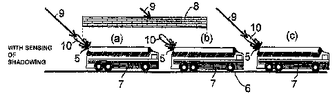
Referring now to FIGs. 5 and 6 makes the advantages
afforded by the method in accordance with the invention
clearly obvious. Each FIG. 5 and FIG. 6 depicts in three
status images in sequence (a), (b) and (c) the pointing
status of a directional antenna 5 mounted on a bus 7
moving to the right on a road 6, in passing a shadowing
zone caused by an obstacle B. In this arrangement FIG. 5
shows the status sequence of known methods with no sensing
of the shadowing whilst FIG. 6 shows the status sequence
in the method in accordance with the invention with
sensing the shadowing.
Once the satellite transmitting the signals has been
correctly sighted by the main lobe 10 of the directional
antenna 5 in accordance with the direction of incidence 9
of the satellite signal, as shown in the status images (a)
of FIG. 5 and FIG. 6, the search for the satellite signal
is initiated after a certain delay as shown in status
image (b) in FIG. 5 without sensing shadowing on loss of
CA 02473479 2004-07-12
12
the satellite signal which, however, is of little sense in
the shadowing.
Once the shadowing has passed, it is highly probable that
the directional antenna 5 is no longer pointing at the
satellite, i.e. the main lobe 10 is no longer pointing in
the direction of incidence 9 of the satellite signal,
meaning that the satellite signal first needs to be
retrieved. This erroneous pointed status is depicted in
status image (c) of FIG. 5.
When, contrary thereto, as shown in FIG. 6 the shadowing
is sensed. No satellite signal search is started during
shadowing, as indicated by status image (b) in FIG. 6 and
the satellite communications link is instantly reavailable
because of there being no change in the pointing of the
directional antenna 5 and its main lobe 10 once the
shadowing has passed. This is shown in status image (c) of
FIG. 6.
During more lengthy shadowing phases there is a
possibility, after the shadowing, of the main lobe 10 of
the directional antenna 5 pointing in the wrong direction,
in other words no longer in the direction of incidence 9
of the satellite signal, due to a change in direction of
the bus 7 and thus of the directional antenna 5 during
shadowing, e.g. in a tunnel with a bend. On sensing the
shadowing the search for the satellite signal is not
started until reception of the satellite signal is again
possible which can substantially shorten the pointing and
acquisition time.
-- --- --- -----
CA 02473479 2004-07-12
13
With no historical data at all as to the search zone, the
full reception range of the directional antenna, e.g. the
complete upper hemisphere needs to be systematically
searched for the satellite signal. It is usually the case,
however, to minimize the time needed in searching for the
signal by making use of historical data in various aspects
in focusing the search zone. Thus, knowing the momentary
position and approximate orientation of the mobile
satellite receiver, for example, furnishes information for
focusing the search zone, since this makes the elevation
and azimuth range known.
Referring now to FIG. 7 there is illustrated how by way of
a diagrammatic fisheye image of the momentary surroundings
of the mobile satellite receiver a hemispherical fisheye
image located in azimuth/elevation coordinates can be made
use of to expedite searching for the signal, by focusing
the search to zones not shadowing by obstacles. By means
of the sensor system additionally provided on the vehicle
in the form of a hemispherical fisheye image, signal
shadowing due to obstacles in the link between the
satellite and the directional antenna are sensed and
information as to the shadowing zones in the field of view
and/or motion range of the directional antenna furnished.
Because of the information obtained by the fisheye sensor
system as to the shadowing zones the pointing and
acquisition mode in the mobile satellite receiver is
disabled for the scan duration of shadowing zones after
tracking, or deactivated following the pointing and
acquisition mode, even when the reception signal has
dropped below a defined threshold for the reception signal
CA 02473479 2004-07-12
14
level which otherwise - in other words when the
directional antenna is erroneously pointed - results in
the pointing and acquisition mode being activated. Now, it
is only after shadowing of longer duration and, of course,
also whenever the pointing of the directional antenna is
sensed to be wrong that a new search for the satellite
signal is started and only in the focused zones not shaded
by obstacles.
CA 02473479 2004-07-12
5
List of Reference Numerals
1 directional antenna
2 direction of incidence of the satellite signal
10 3 main lobe
4 obstacle
5 directional antenna
6 road
7 bus, vehicle
15 8 obstacle
9 direction of incidence of the satellite signal
10 main lobe
25
35