Note: Descriptions are shown in the official language in which they were submitted.
CA 02487276 2012-01-19
1
GRAVITY SURVEYS
Technical Field
This invention concerns an aircraft equipped for conducting airborne
gravity surveys. In another aspect it concerns a process for creating airborne
gravity surveys.
Background Art
In airborne gravity surveys, and particularly in gravity gradient surveys
the major contributor to measured signal is often the topography. In such
situations, very careful modeling of the topographic gradient signal is
required in order to correctly identify that residual part of the signal which
constitutes - exclusive of other generally smaller deterministic disturbances
such as self-gradient - the effect of target anotnalius. Vital to this
correction is
access to a suitably accurate digital elevation map (DEM) which is properly
registered to the aircraft position. Such a DEN-1 rinist cover both the survey
area and a sufficient boundary beyond the survey extent. However, it is the
topography closest to the aircraft, which will have the most profound effect
on the gravity gradient signal.
Summary of the Invention
According to a first aspect of the present invention, there is provided an
aircraft for conducting airborne gravity surveys, equipped with:
an inertial platform in which sits a gravity gradiometer, and which operates
to
provide attitude measurements;
a gravity gradiometer to provide measurements of the gradient of gravity;
a laser scanner to return range and scan angle measurements from the
ground;
a global positioning system (GPS) antennae to receive GPS data from which
timing and position data can be retrieved; and
CA 02487276 2012-01-19
2
a processor to generate a digital elevation map (DEM) using the laser range,
scan angle, aircraft attitude and aircraft position data, and from which the
gradient
of gravity of the topography can be calculated.
Preferably, the invention is an aircraft for conducting airborne gravity
surveys, equipped with:
An inertial platform in which sits a gravity gradiometer, and which
operates to provide attitude measurements.
A gravity gradiometer to provide the gradient of gravity.
A laser scanner having a range of at least 200 m, a scan angle of at least
+/- 30 degrees recorded to an accuracy of at least 0.5 degrees, and a scan
rate
of at least 10 scans per second with a laser pulse rate of at least 10 kHz, to
return range and scan angle measurements from the ground.
A GPS antennae to receive GPS data from which timing and position
data can be retrieved.
A processor to generate a digital elevation map (DEMJ using the laser
range, scan angle, aircraft attitude and aircraft position data, and from
which
the gradient of gravity of the topography can be calculated.
A second ground-based GPS antenna and receiver may be provided at a
reference location for differential correction of the aircraft mounted GPS
2o receiver position.
Preferably, the ground return data obtained using the invention is across a
sufficiently wide swathe so that very adequate DEMs over the whole survey
area can be produced. As a result, the scanner DEM will be correctly
registered relative to the aircraft, especially in the region close to the
aircraft
where topographic gravity gradient effects are not inconsiderable. Also,
scanner DEM's can be composed in remote regions where existing DEMs are
inaccurate, out of date or unavailable - this enables the aircraft to collect
valid data over almost any ground. Furthermore, the scanner DEMs will
generally be more accurate than other commercially available DEMs.
CA 02487276 2012-01-19
3
A laser profilometer may be fitted adjacent to the scanner, to provide
independent data to monitor the scanner integrity throughout a survey.
In order to transform scanner range data into ground return positions, it
is necessary to combine the range data with a measure of the aircraft
attitude,
that is roll, pitch and heading available from the inertial platform, and the
aircraft position available from the GPS. To do this the raw data streams from
the laser scanner and the inertial platform are accurately time stamped with
synchronisation pulses derived from the aircraft GPS. The raw GPS data
from the aircraft and ground GPS receivers may be processed to provide sub-
meter accuracy.
According to a second aspect of the present invention, there is provided a
method for calculating a scanner digital elevation map (DEM) for use in
airborne
gravity surveys, the method using measured attitude data, laser range data and
scan swathe angle data, and aircraft position data, the method comprising the
following steps:
removing data having invalid values from the range data;
interpolating the attitude and aircraft position data onto time synchronised
range data;
vector rotating the range data about a global positioning system (GPS)
antenna to transform the range data into ground position data;
discarding single point anomalies from individual selected scans;
decimating the scans by selecting the points with the lowest ground position
in a number of evenly spaced bins across the scan swathe angle; and
manufacturing a scanner DEM as a gridded version of the scanner ground
position data set using the decimated ground return data.
Preferably, in another aspect of the invention is a process for creating
airborne
gravity surveys using measured attitude data, laser range data and scan angle
data, and aircraft position data. The process comprising the following steps:
Removing data having invalid values from the range data.
CA 02487276 2012-01-19
3a
Interpolating the attitude and aircraft position data onto the range data
time instances.
Vector rotating the range vector and if required the offset vector of the
laser scanner from the GPS antenna about the GPS antenna to transform the
range data into ground position data.
Discarding single point anomalies from individual selected scans.
Decimating the scans by selecting the points with the lowest ground
position in a number of evenly spaced bins across the scan swathe.
Manufacturing a gridded version of the scanner ground position data
set using the decimated ground return data.
Merging the gridded version with a less accurate but larger regional
DEM.
The merging process may consist of the following steps: Overlaying
the scanner DEM on a section of the regional DEM so that the regional DEM
extends at least 5 km further than the scanner DEM in every direction.
Tilting and shifting the regional DEM to match the scanner DEM at the
boundary of the scanner DEM. And allowing the regional DEM to in-fill any
internal gaps in the scanner DEM. The combined scanner and regional DEMs
are used to calculate the gravity gradients which will result from the
topography. The scanner DEM is used in the area it covers, while the
regional DEM is used outside this area. There are public domain methods for
this conversion of topography to gravity gradient.
Brief Description of the Drawings
An example of the invention will now be described with reference to
the accompanying drawings, in which:
Fig. 1 is a schematic diagram of an aircraft.
Fig.2 is a flowchart for the production of scanner DEM.
CA 02487276 2012-01-19
3b
Best Modes of the Invention
A Cessna Grand Caravan* aircraft 10 is equipped with an inertial platform 11
in which sits a gravity gradiometer 12. A Riegl* laser scanner 15 is mounted
under
the tail of the aircraft. A laser profilometer 16 is also mounted under the
tail of the
aircraft to provide a check on scanner ground return accuracy. The aircraft is
also
fitted with dual frequency Dorne-Margolin* GPS antennae 20 and NovAtel
Millennium* receivers 21. Thus equipped the aircraft is able to undertake
airborne
surveys of the local gravity field.
The inertial platform 11 provides very accurate measurements 30 of the
attitude (roll, pitch and heading) of the aircraft, at a rate of 16 Hz, for
range
position correction.
The gravity gradiometer 12 provides a signal from which the
instantaneous gradient of gravity can be derived.
* Trademark
CA 02487276 2004-11-04
WO 02/103398 PCT/AU02/00732
4
The laser scanner 15 provides ground return data 31 in the form of
range measurements and scan angle.
The GPS antennae 20 receives raw GPS data which are processed to
find aircraft position data 32.
Survey Flying
In order to maximise the gradiometer's sensitivity to target signals, a
gravity survey flight plan usually specifies nominal ground clearances of
between 80 and 120 metres, dependent upon topographic relief. These low
clearances enable the laser scanner instruments fitted to the aircraft to
provide good quality and dense ground return data. The laser range, scan
angle, aircraft attitude and aircraft position data are then used to generate
digital elevation map (DEM) position data. The DEM is used to calculate the
gravity gradient along the survey track of the gravity gradiometer so this can
be subtracted from the measured gravity gradients to reveal gravity gradient
anomalies which are not due to the topography.
The Laser Scanner
The laser scanner has a swathe of +/- 40 degrees to give close to full
coverage
at 200 m line spacing and 100 m altitude and a laser range of at least 200 m
to
allow for slant angle and increased altitude over topography. The laser pulses
at 12kHz with a 33% duty cycle and returns 276 readings per scan line at a
line rate of 20Hz to give a separation of less than 3 m along the track and
less
than 1 in across track.
The scanner's nominal specifications are given below:
Parameter Nominal
Value
Scan rate (per sec) 20
Returns per scan 276
Aircraft ground speed (m/s) 50
Scan angle limits(deg) [ +40
Ground clearance (m) 100
Scan separation along aircraft track (m) 2.5
Average scan separation across aircraft 0.60
track (m)
CA 02487276 2004-11-04
WO 02/103398 PCT/AU02/00732
Cross track scan swathe (m) 167
In practice, the scanner performance can vary, with valid scan return
density depending upon factors such as: The aircraft ground clearance
(above 200m clearance return density can be negligible). Ground coverage,
5 for instance the return density over smooth or icy bodies of water is
usually
low and can vary widely according to foliage distribution and characteristics.
Regular cleaning of the scanner window is required.
Scanner Calibration
Both the scanner and profilometer are carefully adjusted when
installed so that the profilometer and the centre of the scan are
approximately
at nadir in the survey flight aircraft attitude. That is at zero pitch and
zero
roll. Additionally, the scan rotation direction must be colinear with the
aircraft's principal axis. In practice, this perfect alignment is impossible
to
achieve, and it is necessary to perform calibration flights to determine the
actual pointing offset of each instrument.
Scanner range and aircraft attitude data are collected whilst a set of
rolling and pitching maneuvers is performed over a flat surface. A body of
flat water with small wind induced rippling is preferred. A least squares
optimisation engine is used to ascertain the best set of scanner pointing
offsets such that the deviation from flatness of the estimated lake surface is
minimised. The same approach is used to calibrate the profilometer. Pointing
offsets for the aircraft fitted with both scanner and profilometer are given
below:
Instrument [roll, pitch, heading] Calibration standard
Pointing Offset (deg) deviation from flatness of
estimated lake surface (m)
Scanner -0.2, 2.8; 2.0 0.2
Profilometer 0.6,-0.27,NA 0.2
The 0.2m standard deviation from flatness of estimated lake surface
reported for both scanner and profilometer is the best possible accuracy
achievable with these instruments, accounting for all possible error sources
from raw measurement through the geometric transformation to final ground
CA 02487276 2012-01-19
6
position. Additional errors are experienced in surveys due to inadequate
foliage penetration, built environment and horizontal position errors.
In order to transform scanner range data into ground return positions, it
is necessary to combine the range data with a measure of the aircraft
attitude,
that is roll, pitch and heading available from the inertial platform, and the
aircraft position from GPS receivers. Synchronisation of these data streams is
achieved by using timing pulses which are exchanged between the separate
instruments and are accurately timed by the GPS receiver.
Calculation Of Aircraft Position
The aircraft and ground based GPS antennae receive raw GPS data,
which are recorded at 2 Hz. Techniques which use these data to generate the
instantaneous position of the aircraft to accuracy of less than 1 m are well
known. An example is the GrafNav* software product (available from Waypoint
Consulting Inc).
Since the intrinsic accuracy of the scanner at low scan angles is very
good, accounting for a ground height error of less than 0.1m standard
deviation. Taking into account that DGPS height errors are about 0. 15m, the
resulting ground height error is estimated as 0.2m standard deviation. This
has been confirmed by an analysis of height differences in overlapping areas
2o between adjacent lines. This estimate is characteristic of a lightly
vegetated
terrain. This level of topographic error has a negligible impact on the
ability
to identify target gravity anomalies arising from geological variations.
Calculation Of Ground Position
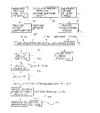
Fig. 2 illustrates the processing steps required to construct a DEM from
the measured attitude data 30, the scanner laser data range and scan angle
data 31, and the calculated aircraft position 32. This process will now be
described:
* Trademark
CA 02487276 2012-01-19
6a
Remove Invalid Range Values 35
The raw range data usually contains a number of invalid range returns,
which are recorded as values less than 20 metres. These are removed from the
data stream.
CA 02487276 2004-11-04
WO 02/103398 PCT/AU02/00732
7
Time Registration and Synchronising with Range Data 40
The lower rate attitude and aircraft position data are linearly
interpolated onto the range data time instances. Processing of scanner
calibration data has demonstrated that the interpolation of the low rate 2Hz
position data can result in ground position estimation errors of up to 0.2m
standard deviation during periods of extreme aircraft attitude change.
However, in normal survey conditions, these extremes of attitude change are
rarely encountered.
Calculate Ground Positions 41
The transformation of range data into ground position is achieved by
performing a set of vector rotations of the range vector about the GPS
antenna. These rotations account for heading, pitch and roll, compensated for
their respective pointing offsets, yaw pointing offset and scan angle as well
as
the lever arm effect associated with the rear mounting of the scanner on the
aircraft underbelly. The transformed range vector is then added to the
aircraft
position, giving the ground return position.
Range Anomalies 42 and Decimation 43
The laser scanner data has many more returns than are required to
generate a sufficiently accurate DEM. It also contains many range values
which are ranges to vegetation which may be several metres above ground
level. The decimation process both reduces the number of range values to be
used in the generation of the DEM, and eliminates the effect of the ranges to
vegetation. The characteristic of the valid ground range values which is used
to distinguish them from returns from vegetation, is that in a localised area
the ground returns will be from lower points than returns from vegetation.
The decimation process is to divide the scanner data into localised areas,
either as sections of a single scan, or combinations of such sections on
adjacent scans, making an area. The lowest height in each localised area is
selected as a true ground return to be used in the DEM generation.
Following the automated decimation process, there may remain a few
anomalous height data associated with dense vegetation or buildings for
example. A manual step 44 of removing these anomalies may then be
employed.
CA 02487276 2012-01-19
8
Creation of DEM 45
The decimated ground return data is then used to manufacture a
gridded version of the scanner ground position data set, the scanner DEM.
This is then merged with a less accurate but larger regional DEM. The
merging process consists of the following steps: Overlaying the scanner DEM
on a section of the regional DEM so that the regional DEM extends at least 5
km further than the scanner DEM in every direction. Tilting and shifting the
regional DEM to match the scanner DEM at the boundary of the scanner
DEM. And allowing the regional DEM to in-fill any internal gaps in the
lo scanner DEM. The combined scanner and regional DEMs are used to
calculate the gravity gradients which will result from the topography. The
scanner DEM is used in the area it covers, while the regional DEM is used
outside this area. There are public domain methods for this conversion of
topography to gravity gradient. This produces gradient measurements
corrected for topographic effects.
It will be appreciated by persons skilled in the art that numerous
variations and/or modifications may be made to the invention as shown in the
specific embodiments of the invention described. The present embodiments are,
therefore, to be considered in all respects as illustrative and not
restrictive, and the
20 scope of the claims should not be limited by the preferred embodiments set
forth in
the examples, but should be given the broadest interpretation consistent with
the
description as a whole.