Note: Descriptions are shown in the official language in which they were submitted.
CA 02514116 2005-07-22
WO 2004/072583 PCT/US2003/004118
HEIGHT GENERATING SATELLITE NAVIGATION SYSTEM
BACKGROUND OF THE INVENTION
1. Technical Field.
[0001] This invention relates generally to a navigation system, and more
particularly
to the generation of standard heights with a satellite navigation system.
2. Background of the Invention
[0002] The height generally. depicted on topographic maps and physical markers
is
the standard height H. The standard height H indicates the height above mean
sea level, and
is determined by geodetic leveling. The standard height system may sometimes
be referred
to as the orthometric height system or the normal height system.
[0003] The National Geodetic Survey determines heights for the standard height
system in the United States by taking physical measurements and using geodetic
leveling.
Government agencies in other countries perform similar functions, such as the
State Survey
Authority of the Federal State of Baden Wurttemberg (Landesvermessungsamt
Baden
Wurttemberg) in Germany, and the Federal Office of Topography (Bundesamt ,
fiir
Landestopographie) in Switzerland.
[0004] Heights obtained from satellite navigation systems, such as the Global
Positioning Systems (GPS) of the United States or the Global Orbiting
Navigation Satellite
System (Glonass) of the Russian Federation, utilize a different height system
than those
obtained with geodetic leveling. Satellite navigation system data is generally
processed to
obtain an ellipsoidal height h. An ellipsoidal height h is a height above or
below a simple
ellipsoid model of the Earth, such as the World Geodetic System 1984 (WGS84)
ellipsoid
model of the Earth.
1
CA 02514116 2005-07-22
WO 2004/072583 PCT/US2003/004118
[0005] Because different height systems are used, the ellipsoidal height h
indicated by
a satellite navigation system for a location may differ by as much as 50
meters from the
standard height H indicated on a printed map for the same location. This
difference may
present a problem when trying to reconcile the height provided by a printed
map with the
height provided by a satellite navigation system. Even though many vehicle
navigation
systems included digital maps, this difference in heights may be a problem
when traveling
either off road or in an area outside of the digitally mapped area.
[0006] To convert from an ellipsoidal height h to a standard height H may
require an
undulation value N. The relationship between the ellipsoidal and standard
height systems
i0 may be expressed by the equation: h = H + N. Accurate transformation
between ellipsoidal
height h and standard height H requires a high resolution undulation N model
of comparable
accuracy to the measured height data. Two examples of such models are the
GEOID96
model in the United States and the Digitale Finite Element Hohenbezugsflache
(DFHBF)
model in Germany.
[0007] It would be desirable to provide a satellite navigation system for use
in a
vehicle that indicates a standard height H for a location. It would be further
desirable to
provide a satellite navigation system for use in a vehicle that provides a
standard height H for
a section of a road. Additionally, it would be desirable to provide a
satellite navigation
system for use in a vehicle that provides a standaxd height H for a section of
a road when the
vehicle is on a road, and also provides standard height H for an off road
location when the
vehicle is not on a road.
SUMMARY
[0008] A vehicle satellite navigation system is provided for generating a
standard
height for a geographic location where a vehicle is located. The system may
include a
satellite receiver, such as a GPS receiver or a Glonass receiver, that is
capable of receiving
radio signals from navigation satellites. The satellite receiver may generate
position data for
the location. The position data may include a longitude, a latitude, and an
ellipsoidal height.
[0009] The system may also include a data storage device. The data storage
device
may store undulation values for a geographic area. The undulation values may
be stored in
an undulation grid model or in a digital map. The undulation values may be
associated with
2
CA 02514116 2005-07-22
WO 2004/072583 PCT/US2003/004118
points in the undulation grid model or with vectors representing sections of
road in the digital
map.
[0010] The system may further include a processor. The processor may be
coupled to
the satellite receiver and to the data storage device. The processor may
receive the position
data from the satellite receiver, and retrieve an undulation value associated
with the position
from the data storage device. The processor may also calculate the standard
height value for
the position. The standard height value for the position may be calculated as
a function of the
ellipsoidal height value and the undulation value.
[0011] Other systems, methods, features and advantages i f the invention will
be or
l0 will become apparent to one with skill in the art upon examination of the
following figures
and detailed description. It is intended that all such additional systems,
methods, features and
advantages be included within this description, be within the scope of the
invention, and be
protected by the accompanying claims.
BRIEF DESCRIPTION OF THE FIGURES
[0012] The invention can be better understood with reference to the following
figures.
The components in the figures are not necessarily to scale; emphasis is
instead being placed
upon illustrating the principles of the invention. Moreover, in .the figures,
like reference
numerals designate corresponding parts throughout the different views.
[0013] FIG. 1 is a functional block diagram of a vehicle satellite navigation
system.
[0014] FIG. 2 is a flow chart illustrating the operation of a processor of a
satellite
navigation system when executing the instructions of a height conversion
application.
[0015] FIG. 3 is a flow chart illustrating the operation of a processor of a
satellite
navigation system when executing the instructions of a navigation application.
[0016] FIG. 4 shows a vehicle having a vehicle satellite navigation system.
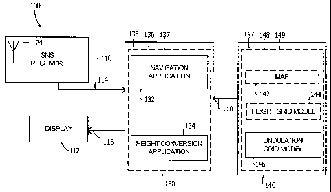
DETAILED DESCRIPTION OF THE PREFERRED EMBODIMENTS
[0017] FIG. 1 is a system level block diagram of an exemplary vehicle
satellite
3o navigation system 100. The vehicle satellite navigation system 100 may
include a satellite
receiver 110, a processor 130, a display 112, and a data storage device 140.
The satellite
3
CA 02514116 2005-07-22
WO 2004/072583 PCT/US2003/004118
receiver 110 may receive radio signals from navigation satellites and
determine a latitude x,
longitude y, and ellipsoidal height h for a position P as a function of the
radio signals. The
vehicle navigation system 100 may be adapted for use with automobiles, trucks,
buses, trains,
motorcycles, bicycles, or the like.
[0018] The position P may be represented as P(x,y,h), where x is the latitude,
y is the
longitude, and z is the height of the position P. The height h of position
P(xy,h) may be an
ellipsoidal height lz, which is a height above or below a simple ellipsoid
model of the Earth.
As an example, the satellite receiver 110 may be a GPS receiver or a Glonass
receiver.
[0019] The satellite receiver 110 may include an antenna 124. The antenna 124
may
to receive radio waves in the operating frequency range of the satellite
receiver 110. For
example, the antenna 124 may be a GPS antenna or a Glonass antenna.
[0020] The data storage device 140 may store undulation values and a digital
map
142. Alternatively, the vehicle satellite navigation system 100 may lack map
functionality, in
which case digital map 142 may be omitted. The undulation values may be stored
by the data
storage device 140 in an undulation grid model 146 and/or as part of the
digital map 142.
The data storage device 140 may include a storage medium such as a hard disk
drive, a
compact disc drive, a digital versatile disc drive, a minidisk drive, a floppy
disk drive, a smart
card drive, a memory stick drive, a memory cartridge drive, a flash memory
drive, or the like.
[0021] The undulation grid model 146 may contain a set N(X,Y) of height
undulation
2o values for positions P(~; Y) in a geographic area, where X is a set of
latitudes x in the area,
and Y is a set of longitudes y in the area. Each undulation value N(xy) may be
associated
with a unique combination of members of sets X and Y such that N(xy)
represents an
undulation value for position P(xy). The undulation values in the set N(X Y)
may contain
data derived from, for example, the GEOm96 model or the DFHBF model.
[0022] As is common in vehicle navigation systems, the digital map 142 may
include
a vector representation for a system of roads. The digital map 142 may contain
a number of
vectors ITS, where each vector VX represents a section of road Sx. The
location and height of
a section of road Sx is generally static. Therefore, rather than dynamically
calculating an
undulation value NX for a section of road SX, the undulation value N~ for the
section of road
3o SX stored in the digital map 142 may be calculated in advance, for example,
during
"preprocessing" of the digital map 142. For each section of road SX, a value
Nx may be
4
CA 02514116 2005-07-22
WO 2004/072583 PCT/US2003/004118
stored in the digital map 142 as an additional attribute of the vector YX
representing the
section of road 5,~.
[0023] The processor 130 may identify and retrieve an undulation value for a
position
P(xy) and generate a standard height for the position P(xy). The processor 130
may include
a navigation application 132 and a height conversion application 134. The
navigation
application 132 may include instructions for causing the processor 130 to
identify and
retrieve an undulation value NX from a vector YX based on a current position
P(xy). The
navigation application 132 may also include instructions for causing the
processor 130 to
generate a standard height for the position as a function of NX
[0024] The processor 130 may include a microprocessor or a microcontroller,
such as
an Intel Pentium microprocessor, a Sun SPARC microprocessor, a Motorola
microprocessor,
or the like. Although shown as separate from the data storage device 140, the
processor 130
and the data storage device 140 may alternatively be integrated into a single
unit.
[0025] The navigation application 132 and a height conversion application 134
may
be stored in a memory 135 of the processor 130. Alternatively, an article of
manufacture 136
may tangibly embody the navigation application 132 and the height conversion
application
134. The article of manufacture 136 may be a program storage device, such as a
magnetic
storage device, an optical storage device, or an electromagnetic storage
device. For example,
the article of manufacture 136 may be a compact disc, a digital versatile
disc, a Minidisc, a
floppy disk, a smart card, a memory stick, a memory cartridge, a flash memory
device, or the
like.
[0026] Alternatively, an electromagnetic signal 137 may embody the navigation
application 132 and the height conversion application 134. The electromagnetic
signal 137
may be a modulated carrier wave propagated through space, a light wave
propagated through
space or a fiber optic conductor, an electrical signal propagated through an
electrical
conductor, or the like. For example, the electromagnetic signal 137 may be a
wireless local
area network signal propagated by an access point to the vehicle satellite
navigation system
100. Additionally, the electromagnetic signal 137 may be a Bluetooth signal
propagated a
Bluetooth enabled computer or a third generation (3G) signal propagated by a
wireless
3o service provider. Furthermore, the electromagnetic signal 137 may be a
light wave emitted
by a light emitting diode or a laser of a fiber optic capable computer. The
electromagnetic
5
CA 02514116 2005-07-22
WO 2004/072583 PCT/US2003/004118
signal 137 may also be an electrical signal from a computer conforming to a
communications
standard, such as an RS-232 signal, RS-488 signal, an IEEE 802 signal, a IEEE
1394, or the
like.
[0027] The navigation application 132 and the height conversion application
134 may
be embodied as one or more programs of instructions executable by the
processor 130. The
processor 130 may execute the one or more programs of instructions directly
from the article
of manufacture 136 or the electromagnetic signal 137. Alternatively, the
processor may read
the instructions from the article of manufacture 136 or the electromagnetic
signal 137 and
store the instructions in the memory 135 prior to execution.
l0 [0028] Similarly, the undulation values stored by the data storage device
140 may be
stored in a memory 147, read from an article of manufacture 148, or read from
an
electromagnetic signal 149. For example, the data storage device 140 may
acquire the digital
map 142 and/or the undulation grid model 146 via the electromagnetic Garner
wave 149 upon
entering a geographic area. The electromagnetic carrier wave 149 may be the
electromagnetic signal 137, or an electromagnetic signal similar in nature to
those discussed
above in regards to the electromagnetic signal 137.
[0029] Additionally, the article of manufacture 148 and the article of
manufacture 136
may be the same physical device. Likewise, the electromagnetic signal 137 and
the
electromagnetic signal 149 may be the same signal. Alternatively, there may be
more than
one physical device comprising article of manufacture 148 or article of
manufacture 136.
There may also be more than one signal comprising electromagnetic signal 137
or
electromagnetic signal 149.
[0030] In operation, the satellite receiver 110 may receive radio waves
(signals) from
navigation satellites and generate a current position P(xy,h) of the vehicle
satellite navigation
system 100. The height h of the position P(x,y,h) may be an ellipsoidal height
h. The
processor 130 may convert the ellipsoidal height la of the position P(xy,la)
to a standard
height H for the position P(xy,l2).
[0031] FIG. 2 is a flow chart illustrating the operation of the processor 130
of a when
executing the instructions of the height conversion application 134. At step
202, a position
3o signal indicating the position P(x,y,h) may be received by the processor
130 from the satellite
receiver 110 via a signal path 114.
6
CA 02514116 2005-07-22
WO 2004/072583 PCT/US2003/004118
[0032] At step 204, the processor 130 may retrieve the undulation value N(x,y)
substantially corresponding to the latitude x and the longitude y of the
position P(xy,lz) from
the undulation grid model 146. At step 206, the processor 130 may convert the
ellipsoidal
height la of position P(x,y,h) to a standard height H. The processor 130 may
calculate the
standard height H by subtracting the undulation value N(xy) from the
ellipsoidal height la.
The undulation value N(xy) may be expressed as a positive or negative number,
so the term
"subtracting" as used herein may refer to adding a negative value, as well as
to subtracting a
positive value.
[0033] At step 208, the processor 130 may generate a display signal indicating
the
to standard height H for the position P(x,y,h). The processor 130 may transmit
the display
signal to the display 112 via signal path 116. In this manner, the standard
height H for the
position P(xy,h) may be communicated to the user.
[0034] FIG. 3 is a flow chart illustrating the operation of the processor 130
when
executing instructions are included in the navigation application 132. At step
302, a position
signal indicating the position P(xy,lZ) may be received by the processor 130
from the satellite
receiver 110 via a signal path 114. At step 304, the processor 130 may
determine and
retrieve a vector hX that represents a section of road SX near to the position
P(xy,h), and read
an undulation value Nx from the vector VX. During preprocessing of the map
142, any section
of road SX that exists in more than one grid square may be, divided into
multiple sections so
that each vector hX may include only one undulation value NX.
[0035] At step 306, the processor 130 may convert the ellipsoidal height la of
position
P(x,y,h) to a standard height H. The processor 130 may calculate the standard
height H by
subtracting the undulation value NX from the ellipsoidal height h. At step
308, the processor
130 may generate a display signal indicating the standard height H for the
position P(xy,la).
The processor 130 may transmit the display signal to the display 112 via
signal path 116. In
this manner, the standard height H for the position P(xy,h) may be
communicated to the user.
[0036] In operation, the processor 130 may execute the navigation application
132
when the current position P(x,y,lz) is "on road," or within very near
proximity to a road.
However, when the current position P(xy,la) is "off road," or not in near
proximity to a road,
3o the processor 130 may execute the height conversion application 134. This
allows for maps
7
CA 02514116 2005-07-22
WO 2004/072583 PCT/US2003/004118
and the like to be displayed when available, and a standard height H to be
displayed during
off road operation
[0037] FIG 4. shows an illustrative vehicle 150 having an exemplary vehicle
satellite
navigation system 100. Coupled to the vehicle 150 are the satellite receiver
110, the
processor 130, the display 112, and the data storage device 140. The display
112 is
preferably mounted in the passenger compartment in a location viewable by a
driver of the
vehicle 150, such as the dash.
[0038] The processor 130 and the data storage device 140 may be mounted, for
example, behind the dash or under seats of the vehicle 150. Alternatively,
where the data
to storage device 140 utilizes some form of removable media, such as a compact
disc, the data
storage device 140 may preferably be mounted in a location accessible by the
driver of the
vehicle 150, such as in the dash.
[0039] The satellite receiver 110 may be mounted, for example, in the trunk of
the
vehicle 150. The antenna 124 may be mounted outside the vehicle, or inside the
vehicle 150
in a location with an unobstructed radio frequency view of the sky. FIG. 4 is
merely
illustrative, and is not intended to limit the claimed invention in any way.
[0040] While various embodiments of the invention have been described, it will
be
apparent tol those of ordinary skill in the art that many more embodiments and
implementations are possible that are within the scope of this invention.
Accordingly, the
2o invention is not to be restricted except in light of the attached claims
and their equivalents.
8